
First impressions of Culver Down are usually the same: a wide chalk headland, a pub by the car park, and those sweeping views over Sandown Bay. Most visitors stretch their legs along the obvious path, snap a few photos of the Yarborough Monument and head back to the beach. Yet this eastern tip of the Isle of Wight has layer upon layer of history, wildlife and quiet corners that rarely make it into guidebooks. Spend a little longer here, step away from the main track, and Culver Down starts to tell a very different story.
A Chalk Ridge with a Hidden Personality
On a map, Culver Down looks straightforward. It is the easternmost point of the Isle of Wight, a chalk down rising to just over 100 metres, dropping on three sides to sea and lowland. In reality, it is a compact landscape where each direction feels different. To the south you look along the arc of Sandown and Shanklin, all sandy beaches and holiday frontage. To the north and east the mood changes, with sheer chalk cliffs, quieter shores and the low wetland of Brading Marshes behind you.
Most visitors drive straight up Culver Down Road from Sandown or Bembridge and park beside the Culver Haven Inn, assuming that is all there is. In fact, the National Trust manages much of the down as open access land, and a network of small chalk and grass paths allows you to circumnavigate the headland. If you follow the fence line above Whitecliff Bay, the familiar pub and monument quickly disappear from view, replaced by larks, rabbit-grazed turf and the hiss of the tide far below.
The name itself hints at a softer side many overlook. “Culver” does not refer to coves, but to doves, from Old English culfre. Historically these downs were known for pigeons and doves rather than cannon and radar. Looking for those gentler traces, from dew ponds to old field boundaries, makes a walk here feel less like ticking off a viewpoint and more like exploring a lived-in landscape.
For a fuller sense of place, approach on foot rather than by car. The Isle of Wight Coastal Path climbs steadily from Yaverland or from Bembridge Ledge, so that the view reveals itself gradually. When you arrive puffing onto the plateau and see the bay suddenly spread out beneath you, the scale of Culver Down makes a far deeper impression than if you had simply stepped from a vehicle.
Wartime Ruins Hidden in Plain Sight
Many visitors notice the concrete rings near the cliff edge and assume they are modern utility structures. In fact, they are the remains of Culver Battery, a coastal artillery site that guarded the eastern approaches to the Solent during both world wars. The battery once held large guns trained on shipping lanes, magazines carved into the chalk, and a Port War Signal Station communicating with vessels bound for Portsmouth and Southampton.
Today, the easiest way to see what is left is to follow the faint track south from the Culver Haven car park to the fenced cliff edge. You will pass over low, grassy mounds that hide underground magazines, then reach the open gun emplacements, their circular bases still visible. Standing here in a fresh southwesterly, with ferries threading the channel and training aircraft turning above Sandown airfield inland, it is easy to imagine the noise and urgency that once filled the headland.
Much of the wartime infrastructure has been deliberately softened by time. The National Trust has allowed turf and wildflowers to reclaim the concrete, so skylarks nest where soldiers once marched. A few interpretation boards appear along the main path, but many details are unlabelled. If you look closely, you can spot rusted rail fixings where narrow-gauge lines carried shells, or the remains of steps descending into what were once shell stores. This mix of semi-ruin and living grassland is part of Culver’s quiet character: history that you discover by looking twice.
Just inland, partly screened by gorse, sits Bembridge Fort, another Victorian and First World War strongpoint. It is often overlooked because it is not always open to casual drop-in visits. On days when the National Trust runs guided tours, you can explore its tunnels and ramparts and see how the fort, battery and headland operated as one defensive system. At other times you only see its outline from the outside, a squat presence above the downs that reminds you how strategic this gentle ridge once was.
Wildlife that Rewards Patience, Not Speed
Culver Down is much more than a viewpoint. The open slopes form part of a wider area of chalk grassland, one of the richest lowland habitats in Britain. Short, grazed turf supports a mosaic of plants such as cowslips in spring, harebells and small scabious in summer, and the pale yellow sprays of lady’s bedstraw. These in turn support invertebrates ranging from day-flying moths to chalkhill blue and marbled white butterflies, which spiral up from the path edges on warm days.
Visitors who hurry from car park to monument and back often miss this miniature world. To see it properly, pick a still afternoon in June or July, walk a few minutes away from the main track and simply stop. Kneel down and look at the turf at eye level. What first looked like plain grass reveals orchids tucked into rabbit scrapes, beetles negotiating bare patches of chalk and a constant shimmer of insect life. The longer you stand still, the more appears.
Above the cliffs themselves, the action shifts to the air. Culver is known as a nesting area for seabirds and for birds of prey that hunt the thermal currents around the headland. Locals keep an eye out for peregrine falcons stooping after pigeons and for ravens performing display flights along the cliff line. You do not need specialist knowledge to enjoy this. Bring a basic pair of binoculars, lean on the fence at the eastern tip and spend twenty minutes watching the tide race and the birds commute along the coast between Sandown and Bembridge.
Even underwater, the chalk geology shapes the wildlife. Erosion of the cliffs feeds chalky material into the sea that helps create offshore rock platforms and reefs. At low tide in quiet coves around Whitecliff Bay and Bembridge Ledge, rockpools hold seaweeds, anemones and small fish that depend on this hard, lime-rich substrate. You may not see the reefs themselves, but by watching what appears in the pools at your feet you are getting a glimpse of a much larger hidden ecosystem tied closely to Culver’s chalk spine.
Secret Bays, Tidal Traps and Quiet Approaches
The obvious way to enjoy Culver Down is from the top. What fewer people realise is that the headland also hides a handful of tucked-away beaches and ledges, some of which are only safe to visit with close attention to the tide. One example is Horseshoe Bay on the south-east side of the headland, a small, steep-sided inlet where the cliffs curve tightly around a shingle and rock beach. Reaching it usually involves timing your walk from Whitecliff Bay around low tide and being prepared for uneven ground and slippery boulders.
For most visitors, a safer and still underappreciated option is to use Culver as the highlight of a longer coastal walk. From Sandown you can follow the promenade north to Yaverland, then pick up the coastal path as it climbs steeply beside the dinosaur museum and the low sandstone cliffs. Within twenty to thirty minutes you emerge onto the open slope of the down, looking back over the whole curve of Sandown Bay. Coming this way early in the morning, when beach traders are just opening kiosks and the light is still soft, gives you a sense of leaving the resort behind as you gain height.
From the Bembridge side, the personality is different. Starting near the lifeboat station or Bembridge Ledge, you follow a narrower path that runs above rockier shoreline and past low scrub. As you climb towards Culver, views open over Bembridge Harbour and its patchwork of houseboats, saltmarsh and moored yachts. This approach feels more intimate and local, passing close to back gardens, small benches and informal paths used by residents walking their dogs in the evenings.
However you reach it, pay attention to the coastline below the cliffs. Parts of the shore between Yaverland, Culver and Whitecliff are remote enough that there may be no easy escape route if the tide comes in against the base of the cliffs. Every year, the coastguard has to help people who underestimate how quickly the sea can cut off these sections. The simplest rule is to enjoy the elevated path for its views and to treat any temptation to drop down to unknown coves with caution unless you have checked local advice and tide tables that day.
Stories in Stone: Monuments, Quarries and Lost Roads
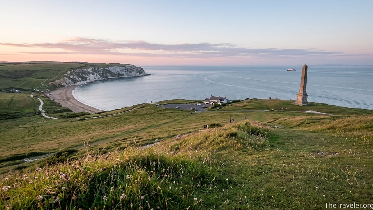
The white obelisk that dominates the skyline on Bembridge Down is not ancient, yet it carries a surprising amount of local story. The Yarborough Monument commemorates Charles Anderson-Pelham, the first Lord Yarborough and founder of the Royal Yacht Squadron. For islanders, it is also a familiar landmark seen from ferries and beaches, a fixed point that appears in childhood memories and postcard views alike. Few visitors realise that a cluster of military buildings once stood beside it, now largely erased except for subtle earthworks and foundations.
Walk a little further inland and you begin to notice other human marks. Old chalk pits bite into the hillside, now partly overgrown with scrub and wildflowers. Some supplied lime for building in Bembridge and Sandown, and in places you can see remains of trackways that once carried carts down towards the villages. A small dew pond, often overlooked in summer when it dries to a muddy circle, hints at older grazing regimes when cattle and sheep needed reliable water high on the down.
Even the access road tells its own story. Before modern surfacing and traffic barriers, older routes climbed the ridge in slightly different lines. On the Bembridge side, you can still follow short sections of what locals refer to as the old road, now used mainly by walkers and riders. These half-lost alignments add a sense of depth when you stand beside the current car park and imagine how different the approach would have felt in a pony cart or on foot a century ago.
Not all traces are obvious. During the sixteenth century, French forces attempted landings along this stretch of coast, leading to skirmishes near Sandown and defences on and around the down. Little from that period is visible above ground, but knowing that Culver’s peaceful slopes once watched hostile sails on the horizon adds another quiet layer to your walk. When the wind drops and the only sounds are sheep and surf, it is hard to picture cannon smoke, yet the headland has seen its share of tension.
Practicalities Most Guidebooks Skim Over
Because Culver Down sits between two holiday centres, many people treat it as a quick stop rather than a half-day destination. That can lead to small frustrations that are easily avoided with a little planning. Parking near the Culver Haven Inn, for example, is limited at peak times in school holidays and on sunny weekends. Arriving early in the morning or later in the afternoon not only makes it easier to find a space but also gives you softer light for photography and more chance of hearing skylarks without the constant background of car doors.
For those using public transport, it is helpful to know that regular buses run between Sandown and Bembridge, with stops near the foot of both approaches. This means you can plan a one-way walk, for example starting in Sandown, climbing over Culver and descending to Bembridge for a late lunch, then catching the bus back. Many visitors are unaware of this simple option and end up retracing their steps over the down in the heat of the day.
Weather deserves more attention here than many short-stay visitors give it. The exposed top catches wind from almost any direction, and conditions can feel several degrees cooler than down on the beach, especially outside high summer. A light shell and an extra layer make it far more pleasant to linger at viewpoints or wait for birds to appear along the cliffs. Conversely, on still summer days there is very little shade, so a hat, sunscreen and water turn a basic leg-stretch into an enjoyable, unhurried exploration.
Looking after the place is also part of travelling well on Culver. Dogs are welcome, but there are grazing cattle and ground-nesting birds in season, so leads may be requested on certain sections. The cliffs are unfenced or lightly fenced in places, and chalk can be slippery when wet, so keeping a few metres back from the edge is simply sensible rather than overcautious. Unlike manicured parks, this is a semi-wild edge between land and sea, and treating it with that respect helps keep the experience authentic for everyone.
Local Life, Quiet Corners and How Not to Rush It
Spend a few hours rather than a few minutes on Culver Down and you begin to notice how locals use it differently from day trippers. Early mornings often see dog walkers doing a regular loop from Bembridge or from the cluster of houses on the inland side of the ridge. They know where the path is driest after rain, which gate catches in the wind, and which benches face away from the prevailing breeze on cooler days. Watching their routines can give you clues about where to find your own quiet circuits.
One underappreciated way to experience Culver is to build it into the middle of your day rather than as a finale. For example, you might start with coffee in Sandown, walk up over the down to Bembridge for a simple lunch at a village cafe, then return by the inland bridleways that cross Bembridge Down and skirt the fort. This makes the headland part of a wider journey through seafront, downland and village rather than an isolated viewpoint, and you will see more gradual shifts in architecture and vegetation along the way.
Sunrise and sunset here are very different experiences, both quieter than the busy middle of the day. At sunrise, the sun emerges over the sea to the east, painting the chalk cliffs in soft pinks and the bay in subtle blues before the light hardens. In the evening, light falls across the bay from behind you, throwing long shadows from the monument and fort while the town lights of Sandown and Shanklin start to twinkle along the curve of the coast. Either moment rewards patience, a thermos and perhaps a notebook or sketchpad more than a rushed snapshot.
If you want to get a sense of Culver’s place in island life, listen as well as look. Snatches of conversation in the car park often involve everyday logistics: school pick-ups, ferry times, the state of the tide at Bembridge Ledge. This is not an isolated beauty spot, but part of a lived-in landscape where tourism, local work, conservation and recreation overlap. Recognising that helps you see why the paths are maintained the way they are, why certain fields are left rough and others closely grazed, and why some areas are signed for seasonal restrictions.
FAQ
Q1. Where exactly is Culver Down and how do I get there without a car?
Culver Down sits between Sandown and Bembridge on the eastern side of the Isle of Wight. Without a car you can take a local bus to either town and then follow the signed coastal path on foot up to the down, allowing about 45 to 60 minutes of walking from seafront level.
Q2. How long does it take to walk around Culver Down itself?
A typical circuit of the headland, starting and finishing near the Culver Haven car park and including the Yarborough Monument and the coastal edge paths, usually takes between 60 and 90 minutes at a relaxed pace, not counting extra time for photographs or birdwatching.
Q3. Is the walk suitable for children and less experienced walkers?
The main tracks are broad and gently graded, so families and less experienced walkers can enjoy them, but there are steep slopes on the approaches and unfenced cliff edges in places. Good footwear, close supervision of children and avoiding the edge in windy or wet conditions make the outing safer and more enjoyable.
Q4. Can I visit Culver Down in bad weather?
You can visit year-round, but the down is very exposed. In strong winds, heavy rain or poor visibility it is wise to shorten your walk, stay well back from the cliffs and consider lower-level paths instead. On days with coastal fog or very strong gusts, many locals simply postpone their visit.
Q5. Are there places to eat or get water on Culver Down?
Near the main car park there is a pub that serves food and drinks in season, but beyond that there are no facilities on the down itself. It is sensible to bring your own water and snacks, particularly if you plan to walk over from Sandown or Bembridge rather than drive.
Q6. What should I wear and bring for a visit?
Even in summer, conditions on the exposed ridge can be cooler and windier than on the beach, so layers and a light waterproof are useful. Sturdy shoes or walking trainers, sun protection, water and, if you enjoy wildlife, a basic pair of binoculars will help you get the most from your time on the headland.
Q7. Is Culver Down accessible for people with limited mobility?
Access directly on to the top of the down from the car park is relatively level, and some short sections of track are firm, but the terrain soon becomes uneven. Wheelchair users and those with very limited mobility may find only the immediate area around the car park comfortable, while others might prefer the gentler promenade at Sandown.
Q8. Are dogs allowed on Culver Down?
Dogs are welcome and many locals walk their dogs there daily. However, you should be prepared to use a lead near grazing animals and during the nesting season for ground-nesting birds, and always keep dogs away from the cliff edge and from any fenced conservation areas.
Q9. When is the best time of year to visit Culver Down?
Late spring and early summer bring wildflowers and butterflies, while clear autumn days often provide superb long-distance views. Winter walks can be exhilarating on calm, crisp days, but short daylight and wet chalk underfoot mean you need to be more cautious about footing and timing.
Q10. What makes Culver Down different from other viewpoints on the Isle of Wight?
Culver combines accessible, panoramic views with a concentration of history and wildlife in a relatively small area. Its wartime remains, chalk grassland, seabird cliffs and links to nearby resorts and villages give it a layered, lived-in character that feels very different from more isolated coastal viewpoints elsewhere on the island.