


Whiteoak Canyon in Shenandoah National Park is one of Virginia’s classic waterfall hikes, with six major falls, cool swimming holes, and routes that range from family-friendly wanders to all-day thigh-burners. Because there are multiple access points and the parking situation can be confusing, a little planning goes a long way. This guide breaks down exactly where to park, how the main routes differ, and what to expect on the ground so you can focus on the water, not the logistics.
Get the latest updates straight to your inbox!
Understanding the Whiteoak Canyon Area
Whiteoak Canyon sits on the eastern side of Shenandoah National Park in Virginia and is essentially a long, steep ravine carved by Whiteoak Run. Along roughly 4 miles of trail you encounter a stacked series of waterfalls and cascades, from gentle slides and pools to an upper waterfall of about 80 feet. Hikers can reach the canyon either from inside the park along Skyline Drive or from the boundary trailhead near the small community of Syria, Virginia.
Most visitors come for one of three experiences: a short out-and-back to the lower falls from the boundary parking, a moderate hike from Skyline Drive to an overlook of the upper falls, or a strenuous loop connecting Whiteoak Canyon with neighboring Cedar Run. All three use the same core trail but start in different places and gain or lose elevation in very different ways, which is why choosing where to park is such an important first step.
Another key factor is that Whiteoak Canyon is popular. On a sunny Saturday in May, boundary parking can fill by mid-morning, and Skyline Drive lots are not far behind. If you are driving out from Washington, DC or Richmond for a day trip, arriving to a full parking lot can derail your plans. Knowing your access options and a few backup strategies will help you avoid circling gravel lots while everyone else is on the trail.
Whiteoak Canyon also overlaps with access routes for Old Rag Mountain, another heavily used destination. That means certain roads, especially Weakley Hollow Road and the approaches from routes 231 and 600, can feel busy in peak season. Thinking through your driving approach, navigation apps, and timing is just as important as studying the trail map.
Parking Inside Shenandoah: Skyline Drive Access
If you want to approach Whiteoak Canyon from the top and avoid some of the steepest climbing early in your hike, parking along Skyline Drive is the most straightforward option. The primary interior access is the Whiteoak Canyon parking area around milepost 42.6 on Skyline Drive, which serves as the trailhead for hiking down to the upper falls overlook and beyond. This paved lot is signed and feels like a typical Shenandoah trailhead: vault toilets in season, trail kiosk, and clearly marked blue-blazed trail leaving from the lot.
From this Skyline Drive lot, a classic route is the Upper Whiteoak Falls hike: roughly 4.5 to 4.7 miles round trip with about 1,000 feet of elevation gain on the return. Many families treat this as a half-day outing. In practice, that means leaving your car at the lot around 9 am, hiking downhill for about an hour and a half to the rocky overlook of the upper falls, then taking two hours or so to climb back up, with photo stops and a snack break included. On summer weekends, the lot often begins to fill by mid-morning, so early arrival is wise if you prefer to park close to the trailhead rather than along the road shoulder where allowed.
Accessing this lot requires entering Shenandoah National Park, typically via one of the main entrance stations on Skyline Drive. Currently, private vehicles pay a per-vehicle entrance fee that covers seven consecutive days. If you are coming in just for the day and have a group of three or four, the fee often works out to about the price of a casual lunch per person and also gives you the flexibility to drive to nearby overlooks or trailheads like Hawksbill or Dark Hollow Falls after your Whiteoak hike.
Driving Skyline Drive itself adds time. For example, driving from Thornton Gap Entrance near Luray down to mile 42.6 on Skyline Drive can easily take 35 to 45 minutes, even though the distance looks short on a map, because the speed limit is low and there are frequent curves and scenic pullouts that tempt quick stops. Travelers coming from Northern Virginia sometimes underestimate this, assuming they can roll out of Arlington at 9 am and be on the Whiteoak Canyon trail by 10:30. In reality, early starts closer to 7 am from the metro area give you a more comfortable cushion for traffic, check-in at the entrance station, and the drive along Skyline Drive.
Boundary Parking: Whiteoak Canyon Falls Lower Trailhead
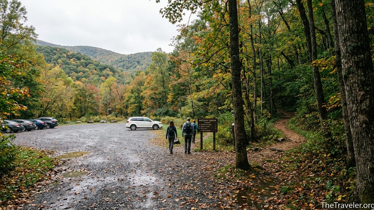
The second major access point is the boundary trailhead, often labeled “Whiteoak Canyon Falls Lower Trailhead” in guidebooks and navigation apps. This sits just outside the official park boundary near the small community of Syria and is reached via a patchwork of rural Virginia roads, typically using Route 231 and Route 600. The parking area here is a large gravel lot adjacent to a small entrance station where rangers often check passes during busier periods.
From this boundary lot, the most popular hike is a roughly 2-mile round trip to the base of the lower falls. Families with children, hikers with limited time, and visitors mainly interested in water play tend to favor this option. In practice, that looks like arriving by 9 or 10 am, hiking gently uphill along the stream for about a mile to the lower falls, spending an hour picnicking on the rocks or letting kids explore shallow pools, then returning to the car by early afternoon. Elevation gain is modest compared to the full canyon route, and the grade feels more like a steady walk than a climb for many visitors.
Despite being just outside the boundary, park rules still apply once you step onto the trail and cross into Shenandoah. That means you still need a valid park entrance pass, whether that is a seven-day vehicle pass, an annual Shenandoah pass, or a national interagency pass like America the Beautiful. At the boundary station, visitors who arrive on busy weekends often see a ranger and a small line of cars as passes are checked and sold. On quieter weekdays, especially outside leaf season, you might encounter a self-pay system with envelopes and instructions. To avoid fumbling with cash or cards in a roadside queue, many hikers purchase their pass online in advance or already hold an annual pass.
Boundary parking has its own capacity limits and quirks. On prime summer Saturdays, the main gravel lot can fill before late morning, and local landowners nearby sometimes open overflow fields or yard spaces for a modest cash fee, which might be around 10 dollars per vehicle. That can be helpful as a backup, but it does not replace the need for a park entrance pass. Practical strategies include arriving early, targeting shoulder seasons like late April or early November, or planning a midweek visit if your schedule allows.
Comparing the Main Routes: Lower Falls, Upper Falls, and Circuit Loops
Once you have a handle on where you can park, the next decision is which route to hike. The simplest is the Boundary to Lower Falls hike from the Whiteoak Canyon lower trailhead. This is usually described as about 2 miles round trip with 500 feet of elevation gain. In real terms, it feels like a gently uphill walk along the creek with a few short steeper sections near the falls. Many first-time visitors choose this option for its high reward-to-effort ratio: you get classic Shenandoah cascades, swimming holes, and towering rock walls with a relatively modest time commitment.
A step up in challenge is the Skyline Drive to Upper Whiteoak Falls hike from the interior lot at mile 42.6. This 4.5 to 4.7 mile round trip loses elevation as you hike down into the canyon and gains it back on your return. Hikers who are used to mountain terrain often find the grade moderate, but it can feel taxing if you are more accustomed to flat city walks. A common pattern on busy summer days is to see families and casual hikers spread out along the trail, with some choosing to linger at intermediate cascades rather than going all the way to the main upper falls overlook.
For experienced hikers, the Cedar Run - Whiteoak Canyon circuit is the marquee challenge in this area. This loop, often listed around 8 miles with nearly 2,800 feet of elevation gain, can begin either from Skyline Drive or from the boundary near Whiteoak. Route descriptions usually recommend strong fitness and a full day to complete it. In practice, fit parties might complete the loop in 6 to 7 hours, but slower groups with frequent breaks can take the better part of a day. Along the way, you pass several waterfalls, including the well-known natural rock slide on Cedar Run, and traverse steep, rocky sections that can be slick after rain.
There are also hybrid options that stitch together pieces of these routes. Some hikers, for example, park at the boundary lot, hike up past the lower falls and several of the middle waterfalls, then turn around whenever the grade or time limit suggests it is wise. Others will start from Skyline Drive, descend to the upper falls overlook, then continue a bit farther, sampling more of the canyon before retracing their steps. The key is to be realistic about your group’s fitness, water and food, and daylight, especially outside summer when dusk comes earlier than many visitors from urban areas expect.
Navigating to the Trailheads and Avoiding Common Pitfalls
Navigation in the Whiteoak Canyon area can trip up first-time visitors, especially those relying heavily on smartphone apps without pre-downloaded maps. Cell coverage drops out in many stretches approaching both Skyline Drive and the boundary trailhead. Travelers driving from Washington, DC often follow navigation to Sperryville, then down Route 211 and onto Route 522 and Route 231 before turning onto narrow rural roads toward Syria. Plugging “Whiteoak Canyon parking” or “Whiteoak Canyon Falls Lower Trailhead” into a navigation app before leaving a coverage area is a wise move.
A common error is confusing Whiteoak Canyon access with Old Rag access. The two share some approach roads, and searches for “Old Rag” can send drivers to older or unofficial parking locations. Shenandoah managers now emphasize using specific labels like “Old Rag Parking Ranger Station” for Old Rag access, and “Whiteoak Canyon” for the canyon hike. While this guidance mainly affects Old Rag, it illustrates how generic map searches can put you on the wrong small road or even dead-end at private property. Reading a simple paper or PDF map before you leave, and cross-checking it with your app, significantly reduces this risk.
Another pitfall is underestimating drive time on rural roads. The last several miles to the boundary trailhead involve narrow pavement where you may find slow-moving farm vehicles, school buses on weekdays, or drivers stopping unexpectedly to check their directions. Even if your navigation shows “30 minutes remaining,” it is smart to pad that estimate, particularly if you are trying to arrive early to secure parking. Visitors staying in nearby lodging, such as bed-and-breakfast inns in Madison or small cabins around Syria, often have an advantage because they can reach the trailhead very early in the day without a long interstate drive.
Once you are at the parking area, finding the trail is straightforward. At Skyline Drive, blue-blazed trail markers and metal trail signs clearly mark the Whiteoak Canyon Trail leaving the lot. At the boundary trailhead, a trail kiosk typically displays maps and safety notices, and the main path follows the creek into the canyon. If you are attempting a more complex loop like Cedar Run and Whiteoak, bringing a printed map or a fully downloaded offline map on a GPS app is essential. Junctions are marked, but in fog, heavy rain, or snow, having your own reference can prevent a wrong turn that adds unplanned miles.
Fees, Passes, and Seasonal Considerations
Whether you park on Skyline Drive or at the boundary trailhead, Shenandoah National Park expects visitors to have a valid entrance pass. The most common choice for day trippers is the seven-day vehicle pass, which is good for the vehicle and all occupants. For travelers who anticipate visiting several national parks in a year, the America the Beautiful annual pass is often a better value and can be purchased in advance. Many regular Shenandoah visitors also opt for a park-specific annual pass, which pays for itself after a few repeat trips during spring and fall hiking seasons.
Passes can be purchased at main entrance stations along Skyline Drive, at some boundary locations including the Whiteoak Canyon lower trailhead during busier times, and online in advance. In practice, this means someone driving in from Charlottesville could stop at Swift Run Gap Entrance, buy a seven-day vehicle pass with a credit card, then continue north on Skyline Drive to the Whiteoak Canyon lot at mile 42.6. Someone coming from the east and heading directly to the boundary lot might purchase a digital pass beforehand and present a confirmation on a smartphone if a ranger is checking vehicles at the boundary station.
Seasons shape both the parking situation and the character of the hike. In late spring and summer, parking lots tend to fill by mid to late morning on weekends, and people are drawn to the canyon for swimming holes and greener foliage along the creek. Mosquitoes and black flies can be noticeable near slow-moving water, and afternoon thunderstorms are a regular concern, making early starts advantageous. In autumn, the canyon becomes a foliage destination, especially in October, with views of colorful hardwoods clinging to rock walls. Parking remains tight on peak weekends, but swimming wanes and the focus shifts to photography and cool-weather hiking.
Winter hikes are quieter, and parking is generally easy, but the risks change. Ice can form on exposed rock near waterfalls and on shaded sections of trail, making trekking poles and microspikes worthwhile for experienced hikers. Some years bring partial freezes of cascades that are spectacular but treacherous if you venture too close. Visitors should also remember that Skyline Drive occasionally closes temporarily due to snow or ice, cutting off interior access to the upper trailhead. In those conditions, boundary access may be the only way to reach the canyon, assuming local roads are clear and safe to drive.
Safety, Etiquette, and Choosing the Right Plan for Your Group
Whichever parking area and route you choose, treating Whiteoak Canyon as real backcountry rather than a city park is essential. The trail involves roots, rocks, wet slabs, and multiple stream crossings, and it passes numerous tempting spots where people like to scramble down close to the water. Over the years, the park has responded to accidents by posting warnings about slippery rocks and the dangers of climbing around waterfalls. A practical rule of thumb is to stay on the established trail, avoid wet rock surfaces near cliff edges, and keep children within arm’s reach near drop-offs.
Water and time management are frequent pain points. Guides commonly suggest carrying at least a quart of water per person per hour of hiking in warm weather. A couple from Richmond who underestimate the canyon’s humidity and bring only one small bottle each for a half-day hike often find themselves turning around early, especially on strenuous routes like the Cedar Run loop. Packing a daypack with at least two liters of water per adult, snacks, a light insulating layer, and a rain shell makes the day far more pleasant, even if the forecast looks benign at the trailhead.
Parking etiquette also matters. At both the Skyline Drive and boundary lots, rangers discourage parking along narrow road shoulders or blocking emergency access. Filling spaces efficiently, avoiding double-parking, and respecting “No Parking” signs help keep the area safe and reduce friction with local residents. When overflow fields or private yards are available near the boundary, paying the requested cash fee promptly and following the landowner’s instructions is both courteous and practical. It is also wise to avoid leaving valuables visible in your vehicle; while serious issues are relatively rare, a clean, locked vehicle is less tempting for opportunistic theft.
For groups with mixed abilities, consider splitting objectives rather than forcing everyone onto the same demanding loop. For example, one family might leave two experienced adults to tackle the Cedar Run - Whiteoak circuit from Skyline Drive, while a grandparent and younger children take a shorter stroll from the boundary lot to the lower falls before meeting up later at their accommodation in Luray or Madison. Clear communication about timing, check-in plans, and contingency options if someone is late goes a long way in an area where cell coverage can be unreliable.
The Takeaway
Planning a hike in Whiteoak Canyon starts with a simple but crucial decision: where to park. Skyline Drive access at mile 42.6 offers a classic national park experience and a natural route to the upper falls, while the boundary trailhead near Syria provides quick access to the lower falls and swimming holes with a more gradual grade. Both require a valid Shenandoah pass and both can fill quickly on prime weekends, so timing and backup plans are essential.
Once you understand how the parking areas link to the main routes, it becomes easier to match the canyon to your goals. Families with limited time can opt for the short Boundary to Lower Falls hike, moderately fit hikers can enjoy the Upper Whiteoak Falls route from Skyline Drive, and experienced adventurers can test themselves on the Cedar Run - Whiteoak circuit. In every case, realistic expectations about drive times, trail difficulty, and changing seasonal conditions will make your day more rewarding.
Whiteoak Canyon rewards those who arrive prepared. A bit of pre-trip map reading, an early start, appropriate passes in hand, and respect for park rules transform logistical puzzles into a smooth, enjoyable visit. With these pieces in place, you can spend less time worrying about where to leave your car and more time listening to the sound of cascading water echoing off ancient rock walls.
FAQ
Q1. Do I have to pay a Shenandoah entrance fee if I park at the Whiteoak Canyon boundary lot?
Yes, you still need a valid park pass even if you park just outside the official boundary. The trail quickly enters Shenandoah National Park, and rangers regularly check passes at the boundary station or on the trail during busy seasons.
Q2. Which parking area is better for families with younger children?
Most families with small children prefer the boundary lot at the Whiteoak Canyon Falls Lower Trailhead. The hike to the lower falls is shorter, the grade is more gradual, and there are several shallow pools and flat rock areas where kids can explore under close supervision.
Q3. How early should I arrive to find parking on a summer weekend?
On popular summer Saturdays and Sundays, aim to be pulling into either the Skyline Drive lot or the boundary lot by 8:30 or 9 am. After mid-morning, it is common to see lots at or near capacity, especially during peak leaf season in October.
Q4. Is it easier to start from Skyline Drive or the boundary trailhead?
“Easier” depends on your route. Starting from Skyline Drive means you hike downhill first and climb on the way back, which some people find psychologically harder. The boundary approach to the lower falls has a milder grade and can feel easier for casual hikers, but longer routes from the boundary quickly become strenuous.
Q5. Can I hike the full Whiteoak Canyon without doing the Cedar Run loop?
Yes. Many hikers simply do an out-and-back on Whiteoak Canyon Trail, going as far up or down as they wish before turning around. You can start at either Skyline Drive or the boundary lot and adjust distance based on your group’s energy and available daylight.
Q6. Are there restrooms at the parking areas?
The Skyline Drive Whiteoak Canyon lot typically has basic restroom facilities in season, such as vault toilets. At the boundary lot, you may find portable toilets or simple facilities near the small entrance area, but services can vary, so it is best not to rely on full-service restrooms.
Q7. Is the Whiteoak Canyon trail suitable for dogs?
Leashed dogs are allowed on the Whiteoak Canyon trail, unlike some other Shenandoah hikes. Your dog must remain on a leash no longer than six feet, and you should be prepared for rocky footing, stream crossings, and potentially crowded sections near waterfalls.
Q8. What kind of vehicle do I need to reach the boundary trailhead?
In dry conditions, a standard passenger car is usually sufficient to reach the Whiteoak Canyon Falls Lower Trailhead via the paved rural roads. The last miles can be narrow and bumpy, but they generally do not require high clearance. In winter or after heavy storms, check conditions, as localized flooding or ice can make access more challenging.
Q9. Can I rely on my phone for navigation and emergency calls?
You should not rely solely on your phone. Signal is often weak or nonexistent both on Skyline Drive and along the boundary approach roads, and it is patchy in the canyon itself. Download maps for offline use and bring a printed map or guide as a backup. For emergencies, understand that help may take time to reach you.
Q10. Is overnight parking allowed at Whiteoak Canyon for backpacking trips?
Overnight parking is generally permitted for backpackers with proper backcountry permits, but rules can change. If you plan to leave a vehicle overnight at either the Skyline Drive lot or the boundary lot, check current Shenandoah National Park guidance in advance and clearly display any required permits or trip plans in your vehicle.