
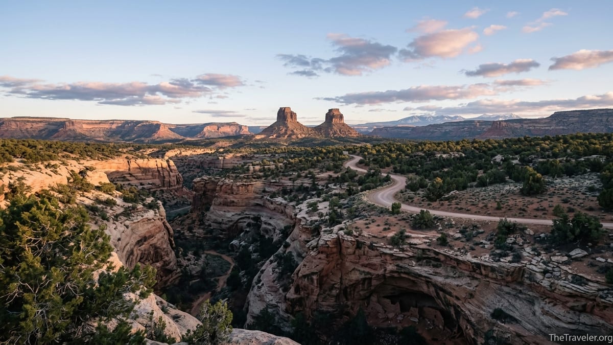
In the high desert of southeastern Utah, twin buttes rise above an expanse of sandstone mesas, piñon-juniper forests, and sinuous canyons carved deep into red rock. This is Bears Ears National Monument, a 1.36-million-acre landscape that has become a touchstone for debates over public lands, Indigenous sovereignty, conservation, and outdoor recreation in the United States. For travelers, it is a place of haunting beauty and rare quiet. For tribal nations, it is a living cultural landscape, rich with stories, ceremonial sites, medicinal plants, and ancestral homes. Understanding why Bears Ears is one of America’s most important places is the first step toward visiting it with the respect and care it deserves.
Get the latest updates straight to your inbox!
A Living Cultural Landscape, Not Just Scenic Desert
To most visitors driving in from Moab or Monument Valley, Bears Ears first appears as a striking feature on the skyline: two rounded buttes that resemble the ears of a bear. What those drivers cannot see from the highway is that the monument protects one of the densest concentrations of Indigenous cultural sites in North America. Archaeologists and tribal experts estimate that there are tens of thousands of sites within the monument’s boundaries, including cliff dwellings, kivas, petroglyph panels, ancient roadways, shrines, farming terraces, and rock art that spans millennia.
On Cedar Mesa alone, south of the buttes, canyons like Grand Gulch, Slickhorn, and Mule Canyon hold generations of Ancestral Puebloan history tucked under overhangs and in alcoves. Hikers who follow the sandy wash into Mule Canyon today can walk past the famous “House on Fire” ruins, where a small cluster of masonry rooms seems to sit under a ceiling of painted flame when the morning light reflects off the canyon wall. A few miles farther up-canyon, the lesser-known Cave Tower complex crowns a rim of slickrock, a rare above-ground tower site that hints at the complexity of life here more than 700 years ago.
For the Navajo Nation, Ute Mountain Ute Tribe, Hopi Tribe, Ute Indian Tribe of the Uintah and Ouray Reservation, and Zuni Pueblo, these are not “ruins” in the detached, museum sense. They are the homes and ceremonial spaces of ancestors whose descendants still live around the monument today. When tribal members gather plants along Comb Ridge, leave offerings at springs, or hold ceremonies near the Bears Ears buttes, they are continuing relationships that stretch back thousands of years. For travelers, recognizing Bears Ears as a living cultural landscape means understanding that each potsherd, petroglyph, and granary is part of an ongoing story rather than a souvenir or photo prop.
This deep cultural significance is precisely why the Bears Ears Inter-Tribal Coalition, representing five tribal nations, came together in 2015 to propose a national monument that would protect both the visible archaeology and the more subtle cultural threads that tie people to the land. When President Barack Obama established Bears Ears National Monument in 2016, it became the first monument in U.S. history proposed and shaped by a coalition of tribes, and the first to formally embed traditional knowledge into its vision for management.
Co-Management: A New Model for Public Lands Stewardship
Bears Ears is also one of the most important landscapes in America because of how it is being managed. After years of legal and political conflict over the monument’s size and status, President Joe Biden restored its full boundaries in October 2021. In June 2022, the U.S. government and the five tribes formalized a cooperative agreement that gives the Bears Ears Commission, made up of tribal representatives, a central role in shaping everything from trail planning to interpretation.
This agreement means that the Bureau of Land Management and the U.S. Forest Service are no longer making decisions in isolation. When land managers consider closing a fragile canyon to camping, rerouting an off-road vehicle track, or designing new visitor education materials, they work directly with tribal experts who bring generations of ecological and cultural knowledge. For example, traditional knowledge might inform when certain herb-gathering areas should be left undisturbed during ceremonial seasons, or how to protect springs that are important both as water sources and as sacred places.
For travelers, co-management has practical effects. A draft resource management plan released in 2024 lays out proposals for limiting dispersed camping in sensitive canyons, concentrating trailhead parking in hardened areas near key access roads such as Utah Highway 95 and 261, and elevating tribal voices in ranger talks and interpretive signs. Visitors may notice bilingual signage that includes Indigenous place names, or guided programs led by tribal members through nonprofit partners in nearby towns like Bluff, Blanding, and Monticello. Rather than hearing only a geologist or archaeologist’s perspective, travelers can learn directly from the people whose stories are rooted in the land.
Bears Ears has quickly become a model for other public lands discussions across the West, from Avi Kwa Ame in Nevada to tribal co-stewardship agreements around national parks and wildlife refuges. For many Indigenous leaders, the hope is that Bears Ears will demonstrate that honoring treaty rights and tribal sovereignty can go hand in hand with high-quality visitor experiences and strong local economies. When visitors choose to hike with local Indigenous guides, support tribally led cultural centers, and follow guidance about respectful behavior at sacred sites, they are helping that model succeed.
Ecological Richness in a Harsh but Fragile Environment
At first glance, Bears Ears can look like an empty desert to travelers used to the lush forests of the Pacific Northwest or New England. Spend a day exploring the canyons, though, and a more intricate picture emerges. The monument stretches from the high country of Elk Ridge, where ponderosa pines and aspen groves catch late-spring snow, down to the warmer, drier country along the San Juan and Colorado Rivers. Elevations vary from roughly 4,000 to over 8,000 feet, creating a series of ecological zones stacked atop one another.
Botanists working with tribal partners have identified well over a hundred plant species in the region that have traditional cultural uses, from food to medicine to ceremony. Piñon pines, which dot the mesas above Butler Wash and Comb Ridge, provide nuts that have sustained Indigenous communities for generations. Sage, juniper berries, wild onions, and yucca are just a few of the plants gathered for food and healing. Springs tucked into canyon walls, like those in Cottonwood Wash or Arch Canyon, create micro-oases where cottonwoods and willows shelter birds and amphibians even in the hottest months.
Wildlife adds another layer of richness. Mule deer move between high and low country with the seasons, while golden eagles and peregrine falcons ride thermals above cliffs near Valley of the Gods and Indian Creek. Desert bighorn sheep navigate seemingly sheer walls, and at night travelers camping legally on established sites may hear coyotes calling across open sage flats. Fossil beds within the monument preserve traces of an even older world, with dinosaur tracks and petrified wood testifying to ancient ecosystems that once covered this corner of Utah.
This apparent abundance is also fragile. Biological soil crusts, the dark, knobbly living skin that covers much of the open desert floor, can take decades to recover from a single footprint or tire track. Cryptobiotic crusts are vital for preventing erosion and helping rare desert plants take root. As visitation has increased, managers have seen more social trails forming along canyon rims, more tire marks cutting across slickrock, and more human waste left at remote campsites. For visitors, understanding the ecological sensitivity of Bears Ears is crucial: staying on durable surfaces, respecting seasonal closures, and packing out all waste are not optional niceties but essential practices for keeping the landscape resilient.
A Contested History of Protection and Threat
Part of what makes Bears Ears so important is the story of how hard it has been to protect. In December 2016, after years of advocacy from tribal nations, archaeologists, local businesses, and conservation groups, President Obama established Bears Ears National Monument at roughly 1.35 million acres. Just one year later, President Donald Trump issued a proclamation that reduced the monument by about 85 percent, carving it into two much smaller units and leaving large stretches of Cedar Mesa, Valley of the Gods, and other areas without national monument protections.
During the years when the monument was shrunk, conservation organizations and tribal leaders documented increases in looting, unauthorized off-road driving, and new claims for mining and drilling on lands that had previously been within the monument. Oil and gas potential in much of Bears Ears is relatively low, but uranium and vanadium deposits have attracted interest in the past, and some exploratory activities resumed once protections were rolled back. For tribal members who had spent years advocating for holistic protection of the cultural landscape, the reductions were felt as both a legal setback and a deep cultural wound.
After legal challenges and nationwide debate over the Antiquities Act, President Biden’s 2021 proclamation restored Bears Ears to slightly more than its original size, at roughly 1.36 million acres, and directed agencies to partner closely with tribes in managing it. While the restoration was celebrated by many tribal governments, conservationists, and outdoor recreation businesses, it has remained controversial among some Utah officials and private landowners who oppose large federal designations. That ongoing tension shapes everything from funding levels for rangers and archaeologists to how quickly new visitor facilities can be built in nearby gateway communities.
For travelers, this contested history matters because it underscores how quickly protections can change and how important public engagement can be. When visitors write thoughtful comments on draft management plans, support local groups that monitor cultural sites, and respect rules even when enforcement seems sparse, they help make the case that monuments like Bears Ears can successfully balance access and preservation. Conversely, a single social media trend that encourages people to scramble into fragile cliff dwellings or camp illegally in closed canyons can undo years of hard work.
Experiencing Bears Ears Respectfully on the Ground
For many travelers, Bears Ears is still a name on a map rather than a specific place they know how to visit. Unlike a traditional national park, there is no main entrance gate or large visitor center. Instead, access is spread across a web of highways and unpaved roads radiating from small towns. Many visitors start in Bluff or Blanding, where local organizations and small information centers can provide up-to-date details on road conditions, permits, and closures, along with maps that show how the monument overlaps with Bureau of Land Management and Forest Service lands.
Some of the most approachable experiences for first-time visitors involve short hikes to overlooks and well-known sites. Butler Wash Overlook, off U.S. Highway 191 south of Blanding, offers a developed parking area, toilets, and a short trail to a viewpoint where visitors can look into a cliff-side complex of ancestral dwellings without approaching or touching them. Similarly, the drive through Valley of the Gods, on a graded dirt road between U.S. 163 and Highway 261, provides wide-open views of towering red rock formations with pullouts where travelers can stop to photograph or simply absorb the quiet.
More adventurous travelers might explore sections of Cedar Mesa, such as the canyons off Utah 95. Day hikers aiming to see House on Fire in Mule Canyon, for example, currently need a day-use permit from the Bureau of Land Management and should plan on an early start to avoid summer heat. Hikers walk a relatively gentle canyon bottom for about an hour before a short scramble up slickrock to view the dwelling from a respectful distance; trip reports often mention carrying binoculars both to see architectural details and to avoid the temptation to get too close. Overnight backpackers in Grand Gulch or Slickhorn must secure overnight permits well in advance, pack out all human waste, and be prepared for remote travel where cellphone service is mostly absent.
Given the monument’s remote character, many visitors choose to stay in small motels or vacation rentals in Bluff or Blanding, or camp at established sites such as Comb Wash. Local outfitters offer guided hikes, photography workshops, and cultural tours that can deepen a visit significantly. Spending a day with a Navajo or Ute guide who can share traditional stories, point out medicinal plants, and explain the cultural meaning of specific rock art panels changes the experience from sightseeing to relationship-building. While guided trips may cost more than going alone, they channel money into local economies and reduce the chances of unintentional harm.
Balancing Recreation, Tourism, and Preservation
As word spreads about Bears Ears, visitation is rising. Photographs of House on Fire circulate widely on social media each spring, while climbers flock to Indian Creek, on the monument’s northern edge, for world-renowned sandstone crack climbing. Mountain bikers explore designated routes, and overlanders follow long dirt roads across Elk Ridge or out toward the Dark Canyon Plateau. Each of these activities brings both economic opportunity and new pressures.
Local businesses in Bluff, Blanding, and Monticello have seen increased demand for lodging, restaurants, guide services, and gear shops. For communities that historically relied on boom-and-bust resource extraction industries, tourism connected to Bears Ears offers the possibility of more stable, long-term income. New small businesses have opened to provide shuttle services to trailheads, cultural interpretation, and responsible off-road tours that stick to legal routes and avoid sensitive sites.
At the same time, tribal leaders and conservation groups have raised alarms about overcrowding at popular trailheads, vandalism of rock art, and the creation of unauthorized campsites. Even seemingly minor actions, like building fire rings in alcoves or moving pottery shards “for a better photo,” can degrade irreplaceable sites. Managers have responded by proposing stricter permit systems in certain canyons, seasonal closures in areas where wildlife is sensitive, and stronger education about basic principles like not touching rock art, not entering structures, and keeping drones grounded near cultural sites and wildlife.
Travelers who want to help tip the balance toward preservation can make a few practical choices. Visiting in shoulder seasons rather than peak holiday weekends reduces crowding. Choosing lesser-known hikes or scenic drives, instead of concentrating only on famous Instagram spots, spreads out use. Supporting Indigenous-led organizations and businesses, whether through tours, art purchases, or donations, helps ensure that those most connected to Bears Ears gain directly from its protection. Perhaps most importantly, visitors can use their own social media platforms to model good behavior, showing photos taken from respectful distances and explaining why some locations should not be geotagged at all.
The Takeaway
Bears Ears is important not only because it is beautiful, but because it embodies a different way of thinking about land, history, and responsibility. Within its boundaries, cliff dwellings perch above canyon floors where cottonwoods trace hidden water, and rock art panels look out over the same horizons they have faced for hundreds or thousands of years. Tribal members still gather plants and hold ceremonies on these mesas, just as their ancestors did long before anyone spoke of “national monuments” or “public lands.”
For the United States, Bears Ears represents a turning point: a place where Indigenous leadership, scientific research, and public access are being woven together into a new model of shared stewardship. The story is far from finished. Management plans are still being finalized, political debates continue, and the impacts of increasing tourism are only beginning to be fully understood. Yet that uncertainty is also an invitation. Every traveler who chooses to learn the history, follow guidance from tribal nations, and tread lightly on the land helps write a better future for this remarkable place.
If you go, go with humility. Expect rough roads, limited services, and more silence than you might be used to. Carry plenty of water, respect closures and permits, and take only photographs and memories. Let the stories you hear from tribal communities guide how you move through the canyons and across the mesas. In doing so, you will not just be visiting one of America’s most important cultural and natural landscapes. You will be participating in the ongoing work of honoring and protecting it.
FAQ
Q1. Where exactly is Bears Ears National Monument located?
Bears Ears National Monument is in southeastern Utah, roughly between the towns of Blanding, Bluff, and Monticello. It stretches from high forests on Elk Ridge down toward the San Juan and Colorado Rivers, encompassing canyons, mesas, and the twin Bears Ears buttes visible from many miles away.
Q2. Which tribes are involved in managing Bears Ears?
Five tribal nations form the Bears Ears Commission that works with federal agencies: the Navajo Nation, Hopi Tribe, Ute Mountain Ute Tribe, Ute Indian Tribe of the Uintah and Ouray Reservation, and the Pueblo of Zuni. They bring traditional knowledge and cultural priorities into decisions about how the monument is managed.
Q3. Is Bears Ears safe and practical for first-time visitors?
Yes, but it requires more self-sufficiency than a typical national park. Roads can be rough, services are limited, and cellphone coverage is patchy. First-time visitors often start with short hikes to overlooks like Butler Wash, scenic drives through areas such as Valley of the Gods, and visits to local information centers for current conditions and maps.
Q4. Do I need permits to hike or camp in Bears Ears?
Permits are required for some popular canyons on Cedar Mesa, such as Grand Gulch and Mule Canyon, especially for overnight trips. Other areas may not require permits for day use but can have specific rules about camping and campfires. It is important to check the latest guidance from local land management offices or visitor centers before setting out.
Q5. Can I visit archaeological sites up close?
Visitors can view many archaeological sites from designated trails and overlooks, but entering structures, touching rock art, or climbing on walls is not appropriate. In some locations, access is deliberately limited or signed to protect fragile masonry and cultural values. Binoculars and zoom lenses are excellent tools for seeing details while maintaining respectful distance.
Q6. What is the best time of year to visit Bears Ears?
Spring and fall are generally the most comfortable seasons, with milder temperatures and fewer afternoon thunderstorms than in midsummer. Summer can bring extreme heat, especially in low canyons, while winter may bring snow and mud to higher elevations. Shoulder-season visits, with flexible plans and good weather information, tend to offer the best experience.
Q7. How can I support tribal communities when I visit?
You can seek out Indigenous-owned guide services, buy art and crafts from local Native artists, and visit tribally connected cultural centers in nearby towns. Listening to and following tribal guidance about respectful behavior at sacred sites, staying out of restricted areas, and sharing accurate information with other travelers also directly supports community priorities.
Q8. Are there campgrounds and lodging near Bears Ears?
Yes. Established campgrounds exist along roads such as Comb Wash and at some highway junctions, while small motels, bed-and-breakfasts, and vacation rentals operate in Bluff, Blanding, and Monticello. Reservations are strongly recommended in peak seasons, and travelers should always arrive with extra water and fuel, since distances between services can be long.
Q9. Why is Bears Ears often described as a “living” cultural landscape?
Because the tribes connected to Bears Ears still use the land for ceremony, plant gathering, hunting, and teaching younger generations. The cliff dwellings, petroglyphs, and artifacts that visitors see are part of ongoing cultural traditions rather than relics of an extinct people. Treating the area as living rather than as a static museum helps guide more respectful behavior.
Q10. What are the most important rules to follow as a visitor?
Key principles include staying on established trails and roads, leaving artifacts and rock art undisturbed, keeping a respectful distance from structures, packing out all trash and waste, and honoring any posted closures or permit requirements. If in doubt, choose the option that causes the least impact, and remember that your actions contribute to whether Bears Ears can remain both accessible and protected for the future.