
Cedar Mesa, on the southern edge of Bears Ears National Monument in southeastern Utah, is one of the most rewarding places in the Southwest for hikers who want to combine rugged desert canyons with world-class archaeological sites. It is also a place where access is tightly managed and conditions change quickly. If you are considering a first trip to Cedar Mesa to explore its canyons and ruins, taking time to understand the hiking routes, permit system and visitor logistics will make the difference between a stressful scramble and a memorable, low-impact journey.
Get the latest updates straight to your inbox!
Understanding Cedar Mesa and Its Place in Bears Ears
Cedar Mesa is a broad, high plateau of sandstone and piñon-juniper woodland west of the town of Blanding, Utah. Most visitors first encounter it while driving Utah Highway 95 or Utah Highway 261, where views stretch over the slickrock canyons that slice into the mesa and down toward the San Juan River. Elevations on the mesa top generally hover between about 6,000 and 7,000 feet, which means cooler temperatures than the lower desert but strong sun and rapid weather changes year-round.
The area forms the southern half of Bears Ears National Monument and is co-managed by the Bureau of Land Management and partner tribes, including the Navajo Nation, Hopi Tribe, Ute Indian Tribe, Ute Mountain Ute and the Pueblo of Zuni. The canyons of Cedar Mesa hold an unusually dense concentration of ancestral Puebloan sites: cliff dwellings tucked into alcoves, granaries high above the wash, rock art panels and scattered pottery sherds. Many of these sites are unmarked, fragile and protected by federal law, which is why land managers have put strict rules and permits in place.
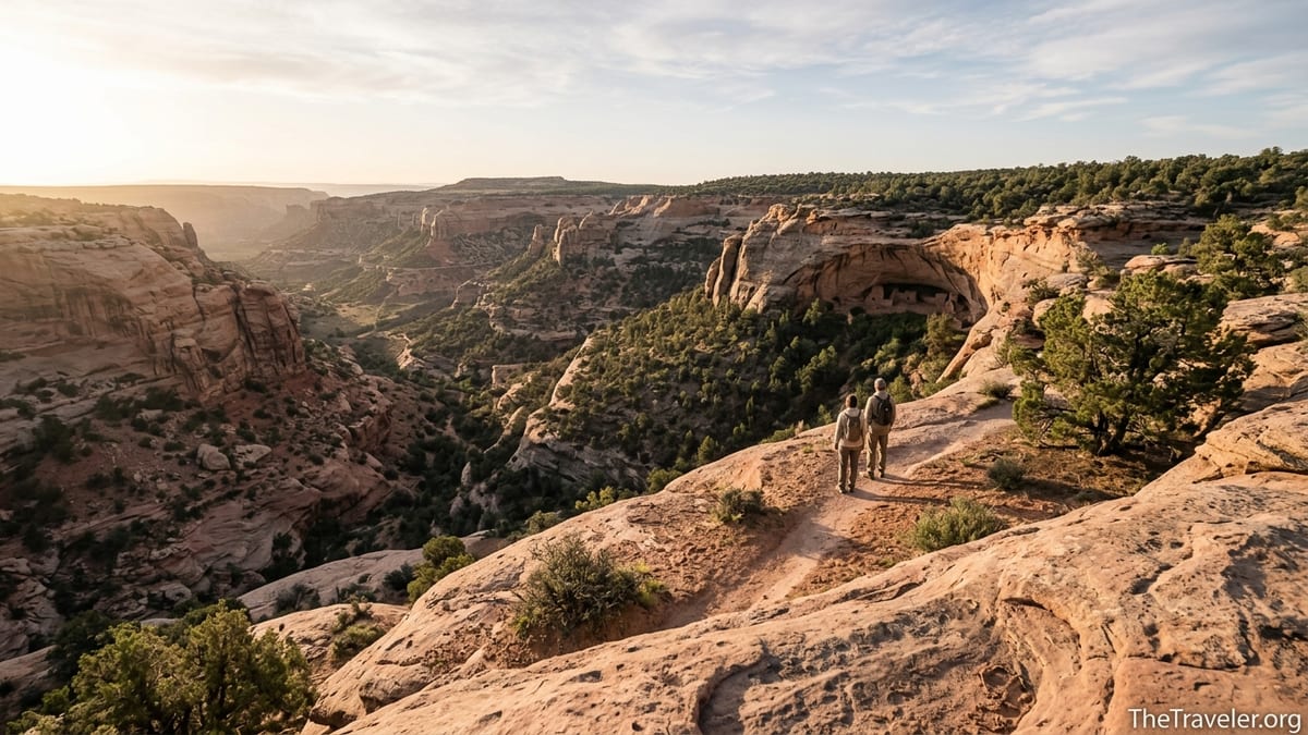
For a first-time visitor, it helps to think of Cedar Mesa as a network of deep canyons cut into a relatively flat tabletop. You park on the rim and hike down a steep, sometimes loose route into a canyon such as Grand Gulch, Slickhorn or Mule Canyon. Once there, you weave along sandy wash bottoms, across slickrock benches and under overhanging cliffs. Distances can be deceptive; a five-mile loop may involve nearly 1,000 feet of elevation change and slow travel over boulders, pools and braided social trails.
Because this is a remote, lightly developed backcountry, you should not expect the kind of infrastructure you might find in a national park. Outside of trailhead vault toilets and a seasonal ranger station at Kane Gulch, there are no services on the mesa itself. That isolation is a big part of Cedar Mesa’s appeal, but it also means you are largely on your own once you leave the pavement.
Key Hiking Routes to Iconic Ruins
Most hikers come to Cedar Mesa with a desire to see at least one well-known ruin or canyon. A good starting point is the House on Fire area in Mule Canyon, reached from a trailhead just off Utah Highway 95. The hike to the famous granaries that glow orange in reflected light when photographed mid-morning is only about 2.5 miles round trip, following a sandy and rocky wash. It is often one of the busiest routes on the mesa, so going early or visiting in shoulder seasons will give you a quieter experience.
Farther west, the canyons feeding into Grand Gulch offer classic day hikes and backpacking routes that combine ruins and remote scenery. Popular access points such as Kane Gulch, Bullet Canyon and Government Trail lead to well-known sites like Junction Ruin and Perfect Kiva. A typical overnight trip might involve dropping into Kane Gulch, camping on a bench above the wash, visiting several cliff dwellings during the day, then hiking out via Bullet Canyon, with a pre-arranged shuttle between trailheads.
Slickhorn Canyon, accessed from several forks off Cedar Mesa’s gravel roads, is known for short but steep entries and a mix of pour-offs, pools and alcoves. The First Fork of Slickhorn, for example, rewards a strenuous descent with access to Perfect Kiva, one of the few restored kivas in the region that hikers are still allowed to enter cautiously. In dry years, pools in Slickhorn can be small and stagnant, so many hikers carry most of the water they will need rather than counting on natural sources.
At the more advanced end of the spectrum is Moon House in McCloyd Canyon, a multi-room cliff dwelling reached by a short but demanding route from a rough 4WD road. The hike is only around 3 miles round trip, but it drops steeply down loose slopes and narrow ledges, and the site itself is heavily regulated with limited daily access. For strong hikers who can secure a permit, Moon House offers a close look at architecture and rock art without the need for a full backpacking trip.
Permits, Passes and How to Plan Ahead
Nearly all hikes that explore the canyons and ruins of Cedar Mesa require some form of paid access, either a day-use pass or an advance permit. Day hiking in the Cedar Mesa and Comb Ridge areas generally requires a day-use permit that you fill out and pay for at self-service fee stations at main trailheads or at kiosks near the Kane Gulch Ranger Station. As of 2026, fees for standard day use are modest and typically charged per person per day, but you should check the latest Bureau of Land Management information shortly before your trip because prices and rules can change.
Backpacking permits are more tightly controlled and must be obtained in advance through the federal online reservation system. The BLM currently caps backpacking use at many Cedar Mesa trailheads at around 20 people per trailhead per day, with a per-person fee for each multi-day trip. Permits for prime seasons, especially spring and fall weekends, can sell out within days of becoming available, so it is wise to know your dates and preferred trailheads several months ahead.
Moon House is a special case. It is the only standard day hike on Cedar Mesa that requires its own dedicated permit, separate from the general day-use system. Access is limited to about 20 people per day, and those permits are released in advance on a rolling basis. In practice, that means if you want to hike Moon House in early May, you should be online roughly three months earlier to secure a slot. When permits sell out, there is no legal way to visit the site that day, and rangers do check.
If you are unsure which canyon best matches your ability and experience, the Kane Gulch Ranger Station serves as the on-the-ground information hub during its spring and fall operating seasons. Rangers there can explain the permit rules, share recent trail and water conditions, and point you to route descriptions and maps for popular options ranging from short family-friendly walks to multi-day backpacks. Calling the Monticello Field Office before you travel is also smart if storms or road closures are in the forecast.
Visitor Logistics: Getting There, Seasons and Base Towns
Cedar Mesa lies in a remote corner of Utah, and reaching many trailheads takes time. Most visitors approach from either Blanding or Bluff along Utah Highway 95, or from Mexican Hat via Utah Highway 261. The famous Moki Dugway, a steep graded dirt section of Highway 261 that climbs the mesa’s southern rim through tight switchbacks, is a highlight for some drivers and a white-knuckle experience for others. Although passenger cars regularly make the climb in dry conditions, it is not suitable for large RVs, trailers or in heavy rain or snow.
Once you are on the mesa top, expect long stretches of graded dirt roads leading to trailheads such as Slickhorn, Moon House and several Grand Gulch access points. In dry weather these roads are usually passable in a high-clearance vehicle and sometimes in a cautious sedan. After sustained rain or spring snowmelt, however, sections can turn to deep mud or feature eroded ledges that require 4WD and careful tire placement. The BLM frequently notes in its conditions reports that some spur roads may be impassable when wet, so it is important to have a backup plan if you arrive and find your originally planned access route is not safe.
Blanding, about an hour’s drive from many Cedar Mesa trailheads, functions as the main supply town, with grocery stores, gas, basic outdoor gear and several motels. Bluff and Mexican Hat, smaller communities closer to the San Juan River, offer additional lodging, small markets and local outfitters that can provide shuttles, guided trips and current advice on road and water conditions. If you are flying in, the most common gateways are larger hubs such as Salt Lake City or Denver, followed by a road trip of several hours across rural highways.
Spring and fall are the marquee seasons. From roughly March through early June and again from September into early November, daytime highs are often comfortable for hiking, while nights can be cool or cold. In summer, temperatures on the mesa and in the canyons regularly soar into the 90s Fahrenheit or higher, and reflected heat off the sandstone can make mid-afternoon hiking dangerous; starting before sunrise and finishing early is the only realistic way to hike then. Winter can bring snow to the mesa top, icy descents into canyons and short daylight, but also solitude and crisp air for those with solid navigation and cold-weather skills.
Respecting Ruins and Tribal Perspectives
The ruins and rock art on Cedar Mesa are not simply scenic backdrops; they are the homes and ceremonial spaces of ancestors whose modern descendants still live throughout the Southwest. Tribal leaders have repeatedly asked visitors to approach these sites with humility, restraint and a willingness to leave things as they are. In practice, that means you should never enter rooms, climb on walls, touch or trace rock art, move artifacts or rearrange stones to “improve” a photograph.
Many of the best-known sites, such as House on Fire, Moon House and Perfect Kiva, have seen a surge in visitation over the last decade. Rangers and local conservation groups routinely report incidents of looting, graffiti and damage from people leaning against walls or walking on fragile midden deposits. Even something as simple as dropping a backpack on a ledge covered in ancient corn cobs can crush irreplaceable material that archaeologists use to understand the past.
Before your trip, it is worth reading about region-specific etiquette campaigns developed by local partners. These stress ideas such as visiting with respect, keeping a safe distance from walls and rock art, taking only photographs, and sharing site locations cautiously so that less-prepared visitors do not get in over their heads. When you are in the field, small choices make a big difference: stepping on bare rock instead of crusted soils, choosing a lunch spot away from ruins, and talking quietly so the canyon retains its sense of calm.
It is also important to remember that many culturally significant places on Cedar Mesa are unmarked or look like ordinary boulders or alcoves to non-experts. If you are unsure whether a scatter of stones, a faint pictograph or a depression in the ground is a site, the safest assumption is that it might be and to give it extra space. By doing so, you help ensure that future generations, including the tribes who advocated for Bears Ears, can continue to connect with these landscapes.
Safety, Water and Backcountry Realities
Hiking on Cedar Mesa is less about racking up mileage and more about moving thoughtfully through complex terrain. Trail signage is minimal, and many routes rely on cairns, faint paths and route-finding along slickrock benches. A typical day might involve weaving around pour-offs, scrambling down loose slopes and backtracking from dead-end side canyons. Because of this, carrying a detailed topographic map, a GPS device or navigation app with downloaded offline maps, and a backup power source for your phone is strongly recommended.
Water is one of the hardest aspects for newcomers to judge. Some canyons hold pools or small trickles throughout much of the year, while others can dry up completely after extended drought. Even when water is present, it may be silty, tannin-stained or contaminated by livestock or wildlife. Land managers emphasize that only water from developed, treated systems is guaranteed safe to drink, which on Cedar Mesa essentially means what you brought in your bottles. Most experienced hikers carry all the water they need for day hikes and bring filters or chemical treatment as a backup for emergencies.
Heat, exposure and flash floods are additional concerns. Long stretches of trail offer little shade, and even on mild days the combination of altitude, dry air and reflected light can lead to dehydration and heat exhaustion. In monsoon season, typically late summer into early fall, intense thunderstorms can turn dry washes into dangerous torrents within minutes, even if the storm cell is miles away. Planning your route so you are not committed to narrow slots or undercut banks when storms threaten is essential.
Wildlife encounters on Cedar Mesa tend to be subtle rather than dramatic: lizards skittering across sandstone, ravens riding thermals, the occasional mule deer or desert bighorn sheep. Mountain lions and rattlesnakes live here too, but it is uncommon to see them. More likely hazards are loose rock, cactus spines, cryptobiotic soil you might accidentally crush, or rodents that can chew through food bags left on the ground. Using rodent-resistant food storage and keeping a clean camp can prevent a minor inconvenience from turning into a ruined meal or torn backpack.
Where to Get Information, Maps and Local Support
Because online descriptions quickly become outdated, especially when storms alter roads or routes, it is wise to back up your pre-trip research with local information. The Kane Gulch Ranger Station on Utah Highway 261 is the primary on-site contact point for Cedar Mesa hikers. In spring and fall, rangers there offer maps and brochures, sell or verify permits, and often require backpackers to watch a brief orientation video that covers Leave No Trace practices and site protection. A conditions report posted at the station typically notes which roads are rough, where water has been seen recently and whether any areas are temporarily closed.
In nearby towns, visitor centers and local conservation organizations provide an additional layer of context. In Bluff, an education center focused on Bears Ears frequently hosts exhibits on local history and tribal perspectives, while outfitters in both Bluff and Blanding run guided hikes for travelers who prefer to explore with a professional. For those new to desert navigation or unfamiliar with the cultural sensitivity of the area, a guided outing can be a valuable way to learn best practices while seeing a few classic sites.
Printed maps and guidebooks remain essential planning tools. The Bureau of Land Management publishes a Cedar Mesa trip planner and detailed maps of Grand Gulch and surrounding canyons, which show trailheads, common routes, water sources that are reliable in average years and permit boundaries. Commercial guidebooks and reputable hiking websites offer route descriptions with estimated times, difficulty ratings and turn-by-turn notes, though you should treat any older publication cautiously and confirm that access rules and site protections have not changed.
If you plan a complex backpacking itinerary, such as a multi-day through-hike linking several canyons, arranging a vehicle shuttle can save you hours of dusty road walking at the end of your trip. Some local companies offer point-to-point transportation between trailheads like Kane Gulch, Bullet Canyon and Government Trail. When budgeting, expect these services to cost a meaningful but fair amount given the long drive on slow roads; calling for quotes as you plan permits will help you decide whether to build a shuttle into your trip.
The Takeaway
Cedar Mesa rewards preparation. The same remoteness and minimal infrastructure that protect its canyons and ruins also mean visitors must come ready to be self-reliant, respectful and adaptable. Hikers who arrive with accurate maps, confirmed permits, realistic expectations about water and weather, and an understanding of how fragile the cultural landscape is are far more likely to come home with the kind of stories that encourage others to care for the place.
Whether you choose a short walk to House on Fire, a day exploring the forks of Slickhorn, or a multi-day journey down Grand Gulch, what you see on Cedar Mesa will likely stay with you long after the red dust has washed from your boots. The silence in a canyon at dawn, the first glimpse of a ruin hidden in shadow, and the sense of walking through a living cultural landscape are hard to find elsewhere. Treat the mesa as a privilege rather than a playground, and it will continue to feel like a rare, hard-won discovery even as more people learn its name.
FAQ
Q1. Do I need a permit to hike on Cedar Mesa?
Yes. Most canyon hikes require at least a day-use pass, and overnight backpacking requires an advance permit with daily quotas at many trailheads.
Q2. How far in advance should I apply for Cedar Mesa backpacking permits?
Permit reservations for popular trailheads and seasons often open several months ahead and can sell out quickly, so planning three to four months in advance is wise.
Q3. Is Moon House open to all hikers with a Cedar Mesa day-use pass?
No. Moon House requires its own specific day-use permit with limited daily slots; a general Cedar Mesa day-use pass is not sufficient to access the site.
Q4. What is the best season to hike Cedar Mesa canyons?
Spring and fall, roughly March to early June and September through early November, usually offer the most comfortable temperatures and more reliable water.
Q5. Can I bring my dog on Cedar Mesa hikes?
Regulations change, but dogs are currently prohibited in some key canyons and at certain ruins; always check the latest Bureau of Land Management rules before bringing a pet.
Q6. Are there marked trails to ruins like House on Fire and Perfect Kiva?
There are established routes and social trails to many popular sites, but signage is minimal, and you should be prepared to navigate using maps or GPS.
Q7. Is it legal to camp near ruins or rock art panels?
No. Camping close to archaeological sites is prohibited. You should choose campsites well away from ruins, rock art and midden areas to protect fragile resources.
Q8. How much water should I carry for a day hike on Cedar Mesa?
Many hikers carry at least three liters per person for a moderate day hike, more in hot weather, since natural water sources may be dry or unsafe to drink.
Q9. Do I need four-wheel drive to reach Cedar Mesa trailheads?
Some major access points are reachable in dry weather with high-clearance two-wheel-drive vehicles, but many side roads become difficult or impassable when wet.
Q10. Are guided hikes available if I am new to desert backcountry travel?
Yes. Outfitters based in nearby towns such as Bluff, Blanding and Mexican Hat offer guided day hikes and backpacking trips that can be a good option for first-time visitors.