
Stand at the corner of Pearl Street and Broad Street at rush hour and you see the New York of finance headlines: hurried suits, delivery cyclists, the glow of trading screens in glass towers. But look down at the uneven cobblestones of nearby Stone Street, or up at the gabled roofline of Fraunces Tavern, and a different city comes into focus. Lower Manhattan is where New York began, and unlike many modern business districts, the past has never fully retreated. It surfaces in street patterns, in repurposed fortresses and customs houses, in memorials and museum doorways tucked between bank logos. That tension is exactly what makes this square mile feel like the part of New York where history is not just remembered but still quietly lived every day.
Get the latest updates straight to your inbox!
A Square Mile Where Centuries Stack on Top of Each Other
Lower Manhattan is New York’s original urban core, and you feel that the minute you step off the wide avenues of Midtown onto its narrow, irregular streets. The district roughly runs from City Hall down to the Battery and from the East River to West Street, and within that compact area you can walk through four centuries of urban change in an afternoon. The tight, twisting lanes in the Financial District follow outlines first laid down when this was the Dutch settlement of New Amsterdam. Unlike the straight grid that defines most of Manhattan north of Houston Street, there is no easy pattern here, only a tangle shaped by the shoreline, colonial property lines and later waves of reconstruction.
That history is literally layered. On Stone Street, one of the city’s oldest thoroughfares, today’s cobblestones sit several feet above the original 17th century paving. You might sit under string lights with an after-work drink while, beneath you, archaeologists have documented fragments of the street that Dutch merchants once paid out of their own pockets to pave. The result for travelers is a district that reads almost like a cross section in a textbook: early colonial lanes, 19th century commercial warehouses, early skyscrapers and postwar office slabs, all within a few minutes’ walk of each other.
What keeps this from being just a backdrop is that these older layers are not preserved as empty shells. The same streets where George Washington walked now house subway entrances and salad chains. Federal Hall, where he took the oath of office as the first president in 1789, stands across from the New York Stock Exchange, its classical façade facing a canyon of glass and steel. Everyday routines unfold in front of national monuments, which means visitors do not just observe history at a distance; they watch locals navigate through it on the way to work.
Streets That Refuse to Forget Their Origins
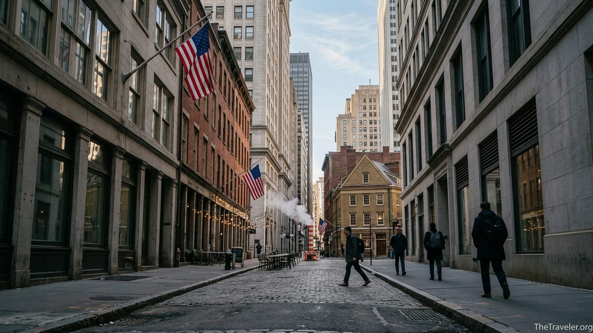
Lower Manhattan’s distinctive street plan is one of the clearest reasons it feels like the past never really left. In much of the city, you can count blocks and predict intersections using numbered streets and avenues. South of City Hall that predictability dissolves. Here, streets like Wall, Pearl, Pine and Cedar break at odd angles, double back, or simply end at the water. Many follow traces of the original coastline before land was gradually filled in, which explains why you can stand on Pearl Street, several blocks from the harbor, even though its name recalls the shell-covered shore of the 17th century.
The scale of the streets is equally telling. In the Financial District around Wall Street and Broad Street, building heights soar while the roads themselves remain only a car or two wide. It creates deep, shadowed corridors that feel more like a European medieval town than a typical American downtown. Travelers notice it immediately when they turn off Broadway into the narrower lanes around Hanover Square or William Street. These proportions are a reminder that the area developed at a time when the primary traffic was on foot or by horse, long before anyone planned for delivery trucks and Ubers.
Stone Street is perhaps the most vivid example. Recognized as the city’s first paved street, it was formally commemorated as a historic district in the 1990s, but its story stretches back to the 1600s. Today, office workers and visitors crowd communal picnic tables for happy hour, framed by restored 19th century brick buildings. Their curved stone stoops and decorative cornices stand in deliberate contrast to the glass office towers a block away. In the early evening, when the canyon-like streets of the Financial District empty out, Stone Street’s cobblestones fill with conversation, proving that a 21st century nightlife scene can coexist with a 17th century street plan.
Old Buildings With New Lives
Another reason Lower Manhattan feels steeped in history is the way its buildings have been reused rather than erased. Over the past few decades, scores of former office towers and commercial blocks have been converted into apartments and hotels, bringing residents back to a district that once emptied after the closing bell. Many of these projects happened in structures that already carried layers of history: early skyscrapers from the 1910s and 1920s, Art Deco towers from the 1930s, and midcentury bank headquarters. Instead of clearing sites for new glass towers, developers kept the ornate lobbies, stone façades and brass elevators, wrapping contemporary loft-style living around them.
Travelers experience this most directly when they check into a hotel or vacation rental housed in a building older than many entire American cities. You might sleep in a former insurance headquarters with a marble-lined lobby and period murals but enjoy rooms outfitted with modern design, Wi-Fi and in-house coffee bars. The Downtown Alliance, the neighborhood’s business improvement district, tracks dozens of these adaptive reuse projects, noting how they have turned quiet daytime blocks into streets where lights stay on and restaurants remain open late.
Some structures have traveled extraordinary journeys through time. Castle Clinton, for example, began life in the early 1800s as a fort on an artificial island off Lower Manhattan, part of the young city’s harbor defenses. In the 19th century it became a performance hall, then one of the country’s busiest immigrant processing centers, predating Ellis Island. Later still it housed the New York Aquarium. Now it functions as a National Park Service site and the departure point for Statue of Liberty and Ellis Island ferries, greeting visitors in Battery Park where the shoreline has expanded around it. Walking through its thick masonry walls before boarding a boat, you are literally moving through several chapters of New York’s story in a matter of minutes.
Where the American Story Has a Mailing Address
Lower Manhattan’s sense of living history is heightened by the concentration of sites tied directly to the formation of the United States. On a ten-minute walk, you can move from Bowling Green, one of the city’s oldest public parks, to Fraunces Tavern and Federal Hall, passing plaques and statues that mark key revolutionary moments. At Bowling Green, visitors still point out the rough stubs atop the decorative iron fence. They recall the day in 1776 when patriots tore down a statue of King George III that had stood in the park, sawing off the royal crowns from the fence posts as part of a public act of defiance.
A few blocks away, Fraunces Tavern occupies a corner of Pearl Street and Broad Street. Built as a residence in the early 18th century and converted to a tavern later that century, it gained lasting fame as the site where George Washington bade farewell to his officers at the close of the Revolutionary War. Today it functions as both a museum and a working restaurant and bar. Visitors can step through low-ceilinged rooms furnished with period pieces upstairs, then head downstairs to a crowded dining room where locals order burgers and pints. It is a rare place where a pivotal national moment coexists with the clatter of plates from weekday lunch service.
Federal Hall, sitting on the site of New York’s first city hall, is equally layered. The building that stands today is an imposing classical structure that once served as a U.S. Custom House, but the location is where the first U.S. Congress met and where Washington was inaugurated in 1789. Tourists line the steps to take photos with the bronze statue of Washington, while traders, lawyers and tourists thread through the same plaza on their way to modern offices. Across the street, the façade of the New York Stock Exchange transforms the space into a physical dialogue between the origins of American democracy and the engine of its contemporary capitalism.
Waterfronts, Seaports and the Memory of a Working Harbor
Walk east toward the East River and the outlines of New York’s maritime past emerge. The South Street Seaport district preserves a cluster of low-rise brick warehouses and cobbled lanes that once bustled with clipper ship trade. Today these buildings house small shops, food markets and restaurants, and their upper floors contain offices and apartments. Yet the docked historic ships, the smell of the river and the creak of rigging on a windy day recall the port city that powered New York’s rise. Modern additions, like contemporary food halls and seasonal rooftop bars, sit alongside preserved counting houses and former wholesalers’ lofts.
On the island’s southern tip, Battery Park folds layers of history into an unexpectedly green space, from military fortifications to immigrant arrivals. Besides Castle Clinton, the lawns and promenades hold memorials to sailors, soldiers and immigrants. Office workers eat lunch under mature trees that long ago replaced rows of cannons. Children climb on playground equipment while, just offshore, ferries shuttle visitors toward Liberty Island, Ellis Island and Staten Island. The park’s role has shifted from front-line defense to front-yard recreation, but it retains the feeling of a threshold between the city and the wider world.
Even the Staten Island Ferry and excursion boats that leave from nearby terminals participate in this continuum. While the ferries themselves are modern, their routes echo centuries of crossings that have tied Manhattan to surrounding harbors and boroughs. For visitors, that means that a simple round-trip ride can double as a lesson in geography and history, as the skyline reveals the way old stone structures and newer glass towers share the waterfront.
From Tragedy to Living Memorial
The events of September 11, 2001 added another powerful historical layer to Lower Manhattan, one that is still evolving within the city’s daily life. The National September 11 Memorial and Museum occupies the former World Trade Center site, with the twin reflecting pools tracing the footprints of the original towers. Office workers and residents pass the plaza on their way to nearby subway stations and shops, while visitors from around the world enter a space designed for reflection. Names of those who died are engraved in bronze around the pools, and on certain days you may see white roses placed by staff to mark birthdays.
Inside the museum, artifacts and exhibits explore both the human stories and the broader impact of the attacks. For travelers, it can be one of the most emotionally intense stops in the neighborhood, but it explains a defining chapter in the district’s recent history. The surrounding streets, once marked by damage and dust, are now home to new commercial towers, transit hubs and public art. Walking along Greenwich Street or through the Oculus transportation hub, you see a rebuilt district that acknowledges its loss but chooses to remain a lived-in part of the city instead of a sealed-off monument.
Smaller memorials and interpretive panels extend this sense of living remembrance beyond the main site. Plaques on nearby buildings list names of fallen firefighters and office workers. Guides from local organizations lead walking tours that interpret how the area has changed since 2001, pointing out surviving structures and explaining how new construction was shaped by improved safety standards. In this way, the story of 9/11 in Lower Manhattan is embedded not only in a museum but also in the design of sidewalks, the routing of streets and the skyline itself.
Walking Lower Manhattan: How Travelers Can Experience the Layers
For visitors, one of the best ways to feel why history lingers in Lower Manhattan is simply to walk. The Downtown Alliance, the local business improvement district, supports a variety of guided and self-guided tours that help decode the landscape, from Revolutionary War routes to tours exploring the neighborhood’s role in the Underground Railroad. Travelers who prefer exploring alone can pick up or download neighborhood maps that highlight key sites within short walking loops. In practice, this might mean starting at City Hall Park, circling through Wall Street and Stone Street, looping to Fraunces Tavern and Battery Park, then finishing at the 9/11 Memorial, all in the space of a few hours.
Experiencing the area over the course of a full day helps reveal its rhythms. Early mornings, when delivery trucks and café workers dominate the streets, feel markedly different from midday, when sidewalks near Broad Street and Wall Street can be crowded with office workers grabbing takeout lunches in the ten to fifteen dollar range from salad bars and fast-casual spots. In the evening, after many financial offices close, Stone Street’s outdoor tables fill, the South Street Seaport’s restaurants light up, and Battery Park draws joggers and sunset watchers. Staying in a nearby hotel or apartment lets travelers see these shifts instead of experiencing the area only as a midday stop on a citywide checklist.
Travelers also notice how practical details reflect the area’s layered identity. Subway lines converge here, with multiple stations named after streets whose paths predate the subway itself, such as Fulton, Wall and Broad. Modern convenience services, from bike-share docks to app-based food delivery, operate in streets originally designed for horses and handcarts. Even the free Downtown Connection bus that loops through the neighborhood feels like a contemporary overlay on a historic street grid, helping visitors move between sites that once took much longer to cross.
The Takeaway
Lower Manhattan feels like the part of New York where history never really left because the past is not walled off in a single museum or preserved district. It shapes how you navigate, where you eat and what you notice at street level. The crooked colonial-era lanes that ignore the city’s famous grid, the forts reborn as ferry terminals, the taverns that host both museum exhibits and after-work drinks, and the memorials woven into a functioning financial center all keep earlier eras in active conversation with the present.
For travelers, that means a visit downtown is less about ticking off a handful of famous stops and more about letting the neighborhood’s layers reveal themselves block by block. You might start the day contemplating Washington’s inauguration at Federal Hall and end it under twinkling lights on Stone Street, or ride a modern ferry from a 19th century fort to see a 19th century statue framed by 21st century skyscrapers. Few places in New York offer such a dense overlap of stories in such a small space. Walk slowly, look up and down as often as you look ahead, and it becomes clear why, in Lower Manhattan, history feels like a persistent neighbor rather than a distant memory.
FAQ
Q1. What exactly counts as Lower Manhattan for travelers?
Most visitors think of Lower Manhattan as everything south of City Hall, from the Financial District and Wall Street area to Battery Park and the South Street Seaport.
Q2. How long do I need to explore the main historic sites?
You can see headline landmarks like Wall Street, Federal Hall, the 9/11 Memorial and Battery Park in half a day, but a full day allows a more relaxed, immersive walk.
Q3. Is Lower Manhattan safe to walk around at night?
Yes, it is generally considered safe, with a strong office and residential presence, though streets can feel quieter after business hours, so standard city awareness is sensible.
Q4. Are there good places to eat that also feel historic?
Yes, Fraunces Tavern offers a museum upstairs and a restaurant downstairs, and Stone Street’s restored brick buildings house lively pubs and restaurants with outdoor seating.
Q5. Can I visit most of the historic locations on foot?
Almost all major sites, from the South Street Seaport to Bowling Green and the 9/11 Memorial, are within a compact area and easy to connect on a self-guided walking route.
Q6. Do I need to book guided tours in advance?
Popular themed walking tours, especially those focused on Revolutionary history or 9/11, often recommend advance reservations, while some general neighborhood tours can be booked same day.
Q7. Is Lower Manhattan a good base to stay in for a New York trip?
It can be an excellent base, with many hotels in historic buildings, quieter nights than Midtown and quick subway connections to Brooklyn, Midtown and beyond.
Q8. Are museums and historic sites here suitable for children?
Yes, many are family friendly, though the 9/11 Museum can be emotionally intense, so families often balance it with time in nearby parks or at the waterfront.
Q9. What is the best time of day to visit the Financial District streets?
Weekday mornings and lunch hours are busiest with office workers, while early evenings and weekends are calmer, making it easier to linger and take photos.
Q10. Do I need special tickets for the Statue of Liberty and Ellis Island from Lower Manhattan?
Yes, ferries depart from Battery Park and use timed tickets, so it is wise to purchase them in advance, especially during peak travel seasons.