
Stand anywhere in central Florence and it will not take long for the Arno River to appear in your line of sight. It glints between palaces, frames postcard views of Brunelleschi’s dome and carries the reflections of the city’s most famous bridge. For visitors, it can feel like a scenic backdrop. For Florence, the Arno is something far more fundamental: a working artery that has shaped the city’s history, economy, layout and even its global image for centuries.
Get the latest updates straight to your inbox!
A River That Drew Florence Onto the Map
Long before Florence became shorthand for Renaissance genius, the Arno was the reason anyone settled here at all. The city grew in a shallow valley carved by the river, on a natural crossing point between the sea and the interior of Tuscany. Roman planners chose this spot in part because the Arno offered a convenient transport route between the Tyrrhenian coast and the Apennine foothills, turning Florence into a stop on wider Mediterranean trade networks rather than just an inland town.
That geography still shapes how travelers experience the city today. The historic center spreads in a narrow band along both banks of the Arno, so many of Florence’s greatest hits are never more than a five to ten minute walk from the water. Walk from the Duomo to the Uffizi, then continue to the river, and you essentially retrace a line that merchants, bankers and diplomats followed in the 14th and 15th centuries when Florence’s wealth was built on textiles and finance.
Because the Arno cuts cleanly through the middle of the UNESCO-listed old town, it acts as a natural orientation line for visitors. Ask a hotel concierge in Santa Maria Novella which way to walk for the Oltrarno crafts quarter and the answer almost always begins with “head to the river, then cross the bridge.” Even walking tours that focus on art or gastronomy tend to pivot around the Arno, using it as a visual anchor as much as a historical one.
For first-time visitors, that straightforward geography is a quiet gift. You can arrive at Santa Maria Novella station, stroll down Via dei Fossi or Via della Scala, and as soon as the street opens onto the lungarno riverfront you feel the city’s layout click into place: north bank for the Duomo, Uffizi and Palazzo Vecchio, south bank for Palazzo Pitti, artisan workshops and the viewpoints in the hills beyond.
From Trade Route to Photogenic Waterfront
In the Middle Ages and Renaissance, the Arno was a transport highway. Flat-bottomed boats brought in timber, grain and construction materials, while mills along the riverbanks powered part of Florence’s early industry. Today you are more likely to see rowing clubs slicing through the water than cargo boats, but the river remains a working space as well as a scenic one, used daily by local sports teams and maintenance barges.
For visitors, its role has subtly shifted from commerce to atmosphere. Many travelers now “meet” the Arno for the first time through a sunset photograph: Ponte Vecchio glowing in honey tones, reflections rippling on the water, the sky behind the hills turning orange. Guides and tourism boards routinely highlight spots like Ponte Santa Trinita or the terrace at Piazzale Michelangelo as essential river viewpoints, recognizing that the Arno is what visually ties the skyline together from dome to tower to bridge.
The city has responded by gradually polishing the riverfront. Stretches of the lungarni such as Lungarno degli Acciaiuoli near Ponte Vecchio have seen wider pavements, new benches and upgraded lighting, turning what were once practical embankments into promenades for evening passeggiate. Recent flood-defense works between Ponte Vecchio and Ponte Santa Trinita added bright, modern barriers that locals debated energetically, a reminder that the Arno is at once a landscape feature and a piece of infrastructure that must be constantly managed.
For travelers, this means the river is not just something to cross on the way from museum to museum. It becomes a destination in its own right: a place to book a hotel room with river views, settle at a café on Lungarno Corsini, or join a guided boat trip at golden hour to glide beneath the bridges and see Florence from the waterline.
Bridges That Tell Florence’s Story
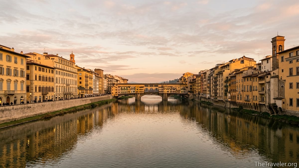
No feature makes the Arno more instantly recognizable than its bridges. The best known, Ponte Vecchio, is a medieval stone span whose row of tiny goldsmiths’ shops has become a symbol of Florence worldwide. During the Second World War it was the only bridge in the city not blown up by retreating German forces, which cemented its near-mythic status and ensured the continuity of the historic streets and buildings that frame it today.
Yet Ponte Vecchio is only one chapter in the story the river’s crossings tell. A short stroll west brings you to Ponte Santa Trinita, a graceful Renaissance bridge rebuilt after wartime destruction with its original elegant curves restored. Stand at its center in the evening and you look straight downriver at Ponte Vecchio, its yellow and ochre facades catching the last light while the Arno reflects a second, shimmering version of the scene. Photographers, including many running local workshops, now cite this precise spot as one of the city’s most rewarding compositions.
Further upstream, Ponte alle Grazie and Ponte alla Carraia offer the same Arno light with fewer crowds. Locals recommend these bridges when visitors ask for “a view like Ponte Vecchio, but quieter.” You might see a couple sharing takeaway gelato from a neighborhood shop or students sitting on the parapet sketching the skyline, using the water and bridges as their perspective lines.
Even the modern Indiano Bridge west of the center, with its striking cable-stayed design, underlines how the Arno keeps shaping Florence’s infrastructure. Drivers arriving from the coast cross here without a second thought, but the structure marks the point where the river begins to widen and shift from historic backdrop to larger Tuscan waterway, with cycling paths and parks tracing its curves out of town.
Floods, Memory and the City’s Relationship With the Water
The Arno is beautiful, but it is also unpredictable. Florence’s history is punctuated by major floods, the most devastating in living memory being the disaster of November 1966, when the river burst its banks and sent muddy water rushing into churches, libraries and homes. Today, discreet plaques around the city quietly record how high the water rose on that day, often several meters above street level. Many visitors encounter these markers without quite realizing they are looking at a gauge of the river’s power.
Those floods profoundly shaped how Florence relates to the Arno. Emergency volunteers known as the “mud angels” became part of the city’s collective memory, and enormous restoration efforts followed to rescue damaged artworks and manuscripts. At the same time, engineers and urban planners began a decades-long program of flood defenses, from upstream reservoirs to reinforced embankments and the more recent barrier projects along the central riverfront.
For travelers, these interventions are mostly invisible, but they are the reason you can sit at a café table on Lungarno Torrigiani in a heavy autumn rain without worrying that the river will suddenly reclaim the street. Occasional high-water alerts still make local headlines, and you may notice temporary metal panels or new pale-colored walls along some stretches between major bridges, added as part of modern protection measures.
This tension between risk and beauty is one of the things that makes the Arno such a defining landmark. It is not a decorative canal or ornamental lake but a real river with a temperament that has to be respected, a fact that colors everything from planning regulations on the floodplain to insurance costs for ground-floor businesses on the banks.
A Living Border Between Two Distinct Florences
The Arno is more than a geographic divider between the north bank and the Oltrarno, literally the “beyond the Arno” district. It is a cultural frontier between two complementary versions of Florence. On the north side you find the dense cluster of blockbuster sights: the Duomo, Piazza della Signoria, the Uffizi, luxury boutiques and large hotels. On the south side, especially in neighborhoods such as Santo Spirito and San Niccolò, the atmosphere softens into a more residential, artisan-oriented feel.
Crossing the river is therefore a small act of psychological travel. Walk over Ponte Vecchio from the Uffizi toward Palazzo Pitti and you move from formal facades and office windows to tiny gold shops perched over the water, then to quieter piazzas where locals linger at bars with a spritz in the late afternoon. Continue to Borgo San Jacopo or Via Santo Spirito and you are in streets lined with workshops where woodcarvers, bookbinders and contemporary designers share space in Renaissance buildings.
Travelers often describe their favorite moments in Florence as “the evening we left the crowds near the Duomo and crossed the river for dinner.” The Arno is the threshold in that story. Look at a restaurant map and you will see how trattorias with outdoor tables on the Oltrarno side cluster close to the river, eager to catch both the breeze and the casual foot traffic of people strolling between bridges at dusk.
The river also structures everyday life for Florentines. Commuters time their routes to cross particular bridges at specific hours when traffic flows better, while joggers adopt the flat, continuous riverbank paths as their de facto running track. For visitors staying more than a night or two, noticing these patterns helps you see the Arno not just as a scenic frame but as the organizing line of the city’s daily rhythms.
The Arno as Florence’s Ultimate Viewfinder
Many of the most celebrated views of Florence are fundamentally river views. Stand at Piazzale Michelangelo at sunset and you look down on a sweep of terracotta rooftops centered around the Arno, with Ponte Vecchio and other bridges slicing across it in neat intervals. That perspective shows clearly how the river stitches the historic quarters together into a single, legible composition.
Closer to the water, each bridge and riverbank corner offers its own informal “viewing platform.” The curve of Lungarno Soderini west of Ponte alla Carraia, for example, provides a long, low perspective where the Arno leads the eye toward the historic center, framed by church towers and the distant dome. Locals in photography forums frequently recommend this exact spot for blue-hour shots, when the city lights flicker on and reflect in the water.
Rooftop bars and hotel terraces trade heavily on their connection to the Arno. A drink at a roof terrace near Piazza della Repubblica becomes something different if your eye is drawn down to the strip of water between the palaces, where you can watch the last light sliding along the river toward the west. Even high-end experiences, such as private tower apertivi sold by luxury hotels, explicitly advertise “Arno views” as part of the package, knowing that the river is the element that turns a pretty skyline into a specifically Florentine one.
Even when you cannot see the Arno itself, you often feel its presence in the way views are composed. A narrow side street suddenly opens onto a balustrade, revealing not just water but the entire opposite bank, or a church corridor ends in a window cut to frame the river. Nowhere is this more literal than in the Vasari Corridor, the elevated passage built in the 16th century to link Palazzo Vecchio with Palazzo Pitti. Its reopening to visitors in recent years has once again allowed people to experience designed viewpoints where windows were carefully placed to look out over both the Arno and the bridges.
Experiencing the Arno Up Close: Walks, Boats and Seasonal Moments
For many travelers, the Arno is at its most compelling when experienced at walking pace. A simple itinerary might involve starting at Ponte alle Grazie in the late afternoon, strolling west along the north bank past the Uffizi, then crossing at Ponte Santa Trinita to return along the south side. Along the way you pass street musicians, couples sharing takeaway pizza slices on the parapet and the changing reflections of palaces and shopfronts in the water.
Some visitors choose to get even closer by taking a small-boat cruise on the river in the warmer months, typically timed for sunset. These outings are usually run in traditional low wooden boats and last about an hour, gliding under Ponte Vecchio and other central bridges. They offer a literal river-level view of Florence that you cannot get from the pavement above, and the cost, while higher than a simple walk, is comparable to a mid-range dinner for two at a central trattoria.
The Arno also structures seasonal experiences. In high summer, when daytime temperatures rise, the riverbank becomes a relative refuge in the evenings as a faint breeze moves along the water. Temporary “urban beach” setups, pop-up bars or cultural events occasionally appear on certain stretches, especially downstream from the center, capitalizing on the combination of open space and waterfront setting. In late autumn and winter, mist sometimes hangs low over the Arno in the morning, partially veiling the bridges and giving photographers a completely different, moodier set of images.
Even simple practical routines, like choosing where to stay, can revolve around the river. Many mid-range and upscale hotels highlight rooms that face the Arno at a premium, and travelers frequently mention waking up to see rowing crews cutting silently along the water at dawn as one of their most vivid memories of the city.
The Takeaway
The Arno River is not just a scenic ribbon sewn into Florence’s postcard views. It is the reason the city exists where it does, the boundary between distinct neighborhoods, a record of floods and recoveries, and the stage on which some of its most iconic images play out. When you look at Florence as a collection of monuments, the river might appear to be a backdrop. Once you start exploring with the Arno in mind, you realize it is the through-line that connects them all.
For travelers, paying attention to the Arno changes how the city feels. Routes become easier to understand, viewpoints more rewarding, and even small choices like which bridge to cross or which side of the river to stroll at dusk turn into moments of discovery. In a city overflowing with masterpieces, the Arno is the quiet constant that defines Florence every single day.
FAQ
Q1. Can you swim in the Arno River in Florence?
Swimming in the Arno within Florence is strongly discouraged and effectively prohibited for safety and water quality reasons; locals and visitors treat it as a river to walk and boat beside, not to swim in.
Q2. What is the best time of day to see the Arno River?
The most atmospheric times are early morning, when rowing crews are out and the light is soft, and sunset, when the bridges and palaces reflect warm colors on the water.
Q3. Which bridge offers the best view of Ponte Vecchio over the Arno?
Ponte Santa Trinita is widely recommended for its direct, unobstructed view of Ponte Vecchio, especially around sunset when the shops and facades catch golden light.
Q4. Are there guided boat tours on the Arno in Florence?
Yes, in the warmer months several operators offer small-boat tours that run through the historic center, usually lasting about an hour and often timed to coincide with sunset.
Q5. How long does it take to walk along the Arno through central Florence?
Walking a central stretch from roughly Ponte alle Grazie to Ponte alla Carraia on one bank takes about 20 to 30 minutes at a relaxed pace, longer if you stop for photos.
Q6. Is it worth staying in a hotel with views of the Arno?
Many travelers feel river-view rooms are worth a moderate price premium, as they offer memorable sunrises, reflections of the city lights at night and an immediate sense of place.
Q7. Does the Arno River still flood Florence today?
Serious floods are now much less frequent thanks to modern dams and embankments, but the city still monitors water levels closely and continues to invest in flood defenses.
Q8. What is the difference between the north bank and the Oltrarno side of the Arno?
The north bank concentrates most major museums and shopping streets, while the Oltrarno side has a more local feel, with artisan workshops, smaller piazzas and popular viewpoints in the nearby hills.
Q9. Are the paths along the Arno good for running or cycling?
Yes, many locals use the relatively flat lungarno embankments for jogging, and there are stretches, especially slightly outside the tight historic core, that work well for casual cycling.
Q10. Where can I find the classic panoramic view of Florence with the Arno and bridges?
Piazzale Michelangelo, on the hillside south of the river, is the classic viewpoint where you can see the Arno cutting through the city, lined with bridges and framed by the Duomo and surrounding hills.