
Rising above the Tornio River Valley in southwestern Lapland, Aavasaksa is one of Finland’s classic national landscapes and a surprisingly easy detour for travelers exploring the north. With sweeping views across Finland and Sweden, a place on the UNESCO World Heritage List through the Struve Geodetic Arc, and atmospheric summer events, this modest 242‑meter hill offers an authentic taste of Lapland without requiring backcountry skills. Here is a practical guide to its main attractions, viewpoints and visitor information, based on the latest details available.
Get the latest updates straight to your inbox!
Where Aavasaksa Is and Why It Matters
Aavasaksa is a forested hill in the municipality of Ylitornio, about 12 to 13 kilometers north of Ylitornio’s village center in Lapland. Drivers on Route 21 (the E8) between Tornio and Rovaniemi can reach the summit area via a paved side road signposted to Aavasaksa, making it one of the most accessible high viewpoints in this part of Finland. The hill stands above the broad valley of the Tornio River, which forms the border with Sweden to the west, while the smaller Tengeliönjoki River curls along its eastern and northern sides.
The site’s reputation as a viewpoint dates back at least to the 17th century, when early travelers to Lapland already climbed Aavasaksa to admire the light of the northern summer nights. In the 18th century the French scientist Pierre Louis Maupertuis used Aavasaksa during his expedition to measure the shape of the Earth, and in the 19th century surveyors of the Struve Geodetic Arc again relied on its prominence. Today, the hill is officially listed as one of Finland’s national landscapes, a symbolic group of vistas selected for their cultural and historical importance.
Aavasaksa is often described as the southernmost point in Finland where the midnight sun can be seen in practice, thanks to its height above the surrounding terrain. Even though the astronomical line for continuous daylight lies slightly farther north, the unobstructed northern horizon from the crest means that on clear evenings around the summer solstice the sun barely dips and then rises again above the landscape.
The area around the summit has been gradually developed for visitors over more than a century. The result today is a combination of wild rock outcrops, spruce and pine forest and a cluster of heritage buildings and viewing structures that make Aavasaksa an easy half‑day excursion with enough variety for families, photographers and history‑minded travelers.
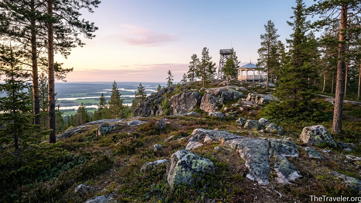
Main Viewpoints and the Observation Tower
The most obvious attraction on Aavasaksa is the observation tower, which stands near the highest point of the hill and offers a 360‑degree panorama. Recent hiking and outdoor guides describe the tower as open year round, with an internal staircase leading to an enclosed viewing level. From here, you can see the broad Tornio River winding south toward Tornio and the Gulf of Bothnia, the smaller Tengeliönjoki River flowing through forest toward the valley, and low fells and ridges stretching north into Lapland.
On clear evenings in June and early July the tower is a favored place to watch the midnight sun hover above the horizon, painting the sky in muted gold and pink. In practice, visitors doing a road trip between Rovaniemi and the coast sometimes time their drive so that they arrive at Aavasaksa late in the evening, climb the tower, take photographs of the river valley and then continue onward or stay in local accommodation in Ylitornio or at Aava Sky Village near the hill.
The tower area also holds tangible traces of Aavasaksa’s scientific heritage. Information boards explain the role of the hill as a measuring point in the Struve Geodetic Arc, the 19th century chain of survey stations stretching from Norway to the Black Sea that helped determine the size and shape of the Earth. The Aavasaksa point is one of six Finnish stations included in the UNESCO World Heritage listing, and on or near the tower you can look for a plaque that marks this status.
In addition to the tower, there are several open rock ledges and constructed viewpoints around the summit area. One especially scenic northern viewpoint looks over the Tengeliönjoki River as it flows down to join the Tornio, while western clearings give views toward the Swedish side of the valley. Paths between the parking areas, tower and viewpoints are relatively short, and for many visitors the main experience is to stroll from one viewing spot to another, taking in the changing angles on the rivers and patchwork fields below.
Imperial Lodge, Historic Buildings and Local Culture
One of the more curious sights on Aavasaksa is the so‑called Imperial Lodge, a decorative wooden pavilion built in the 19th century in an ornate style that feels closer to a villa than a wilderness hut. The building was originally planned with a visit by Emperor Alexander II of Russia in mind, although the imperial visit never took place. Today, the structure survives as an example of early tourism architecture in Lapland and gives a sense of how long Aavasaksa has served as a destination rather than simply a local hill.
The lodge and nearby buildings are part of an area historically referred to as a crown park, emphasizing that this hill was formally recognized and maintained as a scenic site. While detailed opening hours for the interior of the Imperial Lodge can change seasonally and by event, travelers in recent summers often find it open during special occasions and guided tours, particularly around Midsummer celebrations and local festivals. Even when it is closed, the exterior and its setting among pines on the crest make it a natural focal point for photographs.
Close to the main parking and lodge you will also find a small pavilion‑style café and restaurant that has been renovated from an older travel shelter into a neoclassical style building. In recent seasons it has typically operated during the core summer weeks, serving coffee, pastries, simple hot dishes and sometimes offering local souvenirs such as vintage‑style Aavasaksa travel pennants that echo the hill’s mid‑20th‑century tourism heyday. Visitors using it as a rest stop on a long drive often appreciate that prices are comparable to other rural Lapland cafés: expect to pay roughly the same for a coffee and cinnamon roll as you would in small towns elsewhere in northern Finland.
The cultural layer on Aavasaksa is deep for such a small area. Information signs and small monuments reference the Maupertuis expedition, the Struve Geodetic Arc, and the long tradition of gathering here at Midsummer. Many of the boards are bilingual or trilingual, often including Finnish, Swedish and English, which helps international visitors understand why this hill holds a special place in Finnish cultural geography.
Hiking Routes and Outdoor Activities
For many travelers, especially those with limited time, Aavasaksa can be experienced with a short walk from the upper parking lot to the observation tower and back. However, the hill and surrounding forest also offer longer and more varied hiking options. Recent route descriptions from outdoor platforms mention an easy loop of roughly 3 to 4 kilometers that starts and ends near the main summit parking and connects several viewpoints, the tower and heritage buildings. This loop follows well‑marked forest paths and gravel tracks and is suitable for most visitors with basic walking fitness.
More ambitious hikers can link Aavasaksa with longer regional routes. One example is using the hill as a highlight on a multi‑day journey that includes lakes such as Miekojärvi and Vietonen, both known for quiet forest and lake scenery in western Lapland. While such itineraries require more planning, they illustrate how Aavasaksa can serve as a scenic waypoint on a broader Lapland hiking circuit rather than just a quick photo stop.
In recent years Aavasaksa has also begun to host organized outdoor events. Among them are obstacle course style challenges that utilize the varied terrain of the hill. Participants run and climb through forest trails, rocky slopes and constructed obstacles with the wide river valley as a backdrop. For visiting athletes or active travelers, these events give an opportunity to experience the landscape in a more dynamic way, although casual visitors can enjoy the same paths at their own pace outside event days.
In winter, when snow covers the region, Aavasaksa is quieter but does not entirely shut down. The access road is typically maintained, and locals use the area for snowshoeing, winter walks and admiring low polar sunlight or starry skies. The hill’s location well north of the Arctic Circle also makes it a potential vantage point for northern lights on clear nights. However, winter visitors should be prepared for cold conditions, icy steps on the tower and limited daylight, particularly from November to January.
Midnight Sun, Midsummer and Seasonal Atmosphere
One of the main reasons travelers seek out Aavasaksa is the chance to experience the light of the northern summer. Around the summer solstice in late June, nights are luminous across Lapland, and on hills like Aavasaksa the sun can remain visible or just skim the horizon at midnight. Local tourism boards and heritage organizations emphasize that this hill has been used to observe the midnight sun for centuries, and it remains a classic place to bring visiting friends or family for their first polar day experience.
Midsummer, known as Juhannus in Finnish, is a particularly atmospheric time. Modern events on and near Aavasaksa typically include music, dancing and social gatherings under the pale night sky. In recent years, nearby Aava Sky Village and other local operators have promoted Midsummer celebrations featuring live performers, food services and viewpoints specifically chosen for the midnight sun. While exact programs change from year to year, the core idea is consistent: spend the evening outdoors on the hilltop, watch the sun glide along the horizon, and enjoy a festive but relaxed Lapland setting.
Travelers planning a visit around Midsummer should be aware that this is a major national holiday in Finland. On the Friday and Saturday closest to the summer solstice, shops and many services across the country operate on reduced hours or close altogether, while roads toward lakes, the coast and countryside can be busy as locals travel to summer cottages. On the practical level, this means that if you want to combine Aavasaksa with grocery shopping or other errands, it is wise to handle those earlier in the day in Ylitornio or in larger towns such as Tornio or Rovaniemi before heading up the hill.
Outside the brief peak of Midsummer, Aavasaksa offers a quieter but equally impressive light show throughout the light weeks of June and early July. Photographers often favor slightly overcast evenings with broken cloud, when the low sun paints bands of color over the valley and reflections ripple on the rivers. Even in August, when nights begin to darken again, the viewpoints remain excellent for sunsets and soft evening light.
Practical Visitor Information and How to Get There
Reaching Aavasaksa is straightforward by car. From the village of Ylitornio, drivers follow signs toward Aavasaksa, turning off the main Route 21 onto Aavasaksanvaarantie, which climbs through forest to the summit area. Official tourist information references this road and gives the address Aavasaksanvaarantie 279 for navigation devices. The drive from central Ylitornio takes around 15 to 20 minutes, while those coming from Tornio should allow roughly an hour depending on conditions.
Near the top of the hill there are parking areas that serve the observation tower, Imperial Lodge and main viewpoints. In summer, these can become busy in the late evening if the weather is good and a strong midnight sun is expected, but the turnover of visitors is high and patience usually secures a space. From the upper parking lot, paths to the tower and viewpoints involve some short but sometimes steep sections, so sturdy shoes are recommended even for casual visitors.
Public transport options directly to the summit are limited. Long‑distance buses running along Route 21 generally stop in or near Ylitornio’s center rather than ascending to Aavasaksa itself. Travelers relying on public transport can combine a bus journey with a local taxi ride from Ylitornio to the summit, or in summer arrangement, a bicycle rental followed by an uphill ride. Because schedules and services in Lapland can change from season to season, it is sensible to check current bus times and taxi availability shortly before traveling.
Basic facilities at the summit include outdoor toilets, picnic spots and fire sites, though open fire use is always subject to current forest fire warnings issued by Finnish authorities. In high summer the seasonal café near the pavilion typically offers drinks and light meals, but outside the core weeks you should assume there are no food services on the hill and bring your own snacks and water. Mobile coverage is generally good enough for navigation and simple online use, but as in much of rural Lapland it can vary with operator and exact location.
Nearby Services and Suggested Itineraries
Although Aavasaksa feels quite remote on the crest, services in and around Ylitornio complement a visit well. Down in the valley, Ylitornio provides grocery stores, fuel stations, cafés and accommodations ranging from basic guesthouses to modern cabins and apartments. For those who want to stay as close as possible to the hill, holiday villages and cabin complexes in the immediate vicinity cater to visitors looking to watch the midnight sun or northern lights without long late‑night drives.
A practical itinerary for road trippers might involve starting from Tornio or Haparanda on the Finnish–Swedish border, driving north along the Torne Valley, stopping in Ylitornio for supplies, then continuing up to Aavasaksa in the late afternoon. After walking the summit loop, visiting the tower and Imperial Lodge exterior, and having dinner at the summit café if open, travelers can stay to watch the midnight sun before descending to an overnight stay in Ylitornio or nearby lakeside cabins.
Another option is to fold Aavasaksa into a larger Lapland circuit between the coast and inland capital of Rovaniemi. Drivers coming from Rovaniemi can follow Route 4 south for part of the journey and then connect westward, or travel via side roads through small villages and forest sections, arriving at Aavasaksa from the east. In this case, the hill serves as a scenic high point at roughly the midpoint of a day’s drive, offering a chance to stretch legs, picnic and take panoramic photos before continuing.
Because the Tornio River Valley is a border region, it is easy to combine Aavasaksa with short trips into Sweden. After descending from the hill, travelers can follow the river north or south and cross at local bridges, experiencing how Finnish and Swedish villages share a continuous cultural landscape along the river. This cross‑border character, combined with the hill’s own UNESCO‑linked history, makes Aavasaksa feel connected to a wider northern story despite its modest size.
The Takeaway
Aavasaksa is not the highest hill in Lapland, nor the most remote, but it condenses a remarkable amount of history, scenery and atmosphere into a small and accessible area. From the observation tower and open rock ledges you can scan long river valleys, glimpse Swedish forests across the border and, in the height of summer, watch the midnight sun brush the horizon. The Imperial Lodge and summit café recall more than a century of tourism, while the discreet UNESCO plaque ties this quiet hilltop to a multinational scientific project that mapped the planet.
For travelers driving through northern Finland, Aavasaksa works equally well as a short scenic detour, a sunset or midnight sun destination, or the focal point of a leisurely day that combines hiking, café stops and cultural exploration. It rewards those who linger long enough to watch the light change and to read the storylines on its information boards. With realistic planning for limited public transport and seasonal services, it is straightforward to fit into almost any Lapland itinerary.
Above all, Aavasaksa offers a human‑scale introduction to Lapland’s big skies and quiet forests. Whether your goal is a single photograph from the tower, a family picnic, or an evening spent following in the footsteps of early explorers and surveyors, this hilltop national landscape delivers an experience that feels both grounded in local life and open to the endless northern horizon.
FAQ
Q1. Where exactly is Aavasaksa located?
Aavasaksa is a hill in the municipality of Ylitornio in southwestern Lapland, Finland, rising above the Tornio River Valley a short drive north of Ylitornio’s center.
Q2. How do I get to the Aavasaksa viewpoints without a car?
Long distance buses typically reach Ylitornio, from where you can take a local taxi or cycle up the summit road. There is no regular public bus service directly to the top, so planning onward transport from the village is essential.
Q3. Is there an entrance fee to visit Aavasaksa or the observation tower?
The hill, viewpoints and observation tower are generally free to access. Special events or guided tours may charge a separate fee, but casual visitors can usually walk the area without paying an entrance charge.
Q4. When is the best time to see the midnight sun from Aavasaksa?
The best period is around the summer solstice in late June, extending roughly from mid June to early July, when nights are brightest and the sun can hover near the horizon at midnight in clear weather.
Q5. Are the paths and tower suitable for children and less experienced walkers?
Yes, most visitors with basic mobility can manage the short walks between parking areas, viewpoints and the tower, though there are some steeper sections and steps. Sturdy footwear is advisable, and young children should be supervised near rock edges.
Q6. What services are available at the top of Aavasaksa?
In summer you can usually find parking, outdoor toilets, picnic spots and a seasonal café near the historic pavilion. Outside the main season, services may be limited to parking and basic facilities, so carrying your own food and water is wise.
Q7. Can I visit Aavasaksa in winter, and is it worth it then?
Yes, the access road is typically maintained and locals visit year round. In winter you will not see the midnight sun, but you can experience snow covered forests, low polar light and, on clear nights, potential northern lights views from the hill.
Q8. What is the connection between Aavasaksa and UNESCO?
Aavasaksa hosts one of the Finnish station points of the Struve Geodetic Arc, a 19th century chain of survey points that is inscribed on the UNESCO World Heritage List, and this heritage is explained on plaques near the tower.
Q9. Are there accommodation options close to Aavasaksa?
Yes, Ylitornio and the surrounding valley offer guesthouses, cabins and small hotels, and there are holiday villages and cabin complexes in the immediate vicinity of the hill. Booking in advance for peak summer dates is recommended.
Q10. Do I need special equipment to hike around Aavasaksa?
For typical summer visits, comfortable walking shoes, layered clothing and basic rain protection are sufficient. In shoulder seasons or winter, warmer clothing, traction aids for icy paths and possibly snowshoes make exploring the area safer and more comfortable.