
Utsjoki, tucked into the far north of Finnish Lapland on the border with Norway, feels like the end of the road and the beginning of something wild. This is the only municipality in Finland where the majority of residents are Sámi, and it offers a rare blend of quiet Arctic villages, deep river valleys and strict nature reserves that still feel genuinely remote. If you are looking for clear maps, reliable visitor information and concrete ideas for what to see and how to get around, this guide brings together the essentials you need before heading to the very top of mainland Europe.
Get the latest updates straight to your inbox!
Orientation: Where Utsjoki Is and How It Is Laid Out
Utsjoki sits in the northernmost corner of Finland, in Lapland, just across the river from Norway. The municipality stretches along the Teno (Tana) River valley, with small villages scattered over a very large area. For trip planning, it helps to know that when people say “Utsjoki,” they often mean both the municipality and the compact village center where you will find basic services and the main visitor information point.
The village of Utsjoki lies by the E75 highway, a north–south road that runs all the way from Rovaniemi up to the Norwegian border and beyond. The Teno River marks the border between Finland and Norway, with the Finnish village of Utsjoki on one side and Norwegian Tana Bru within easy driving distance on the other. Further north within the municipality are smaller settlements like Nuorgam, which is Finland’s and the European Union’s northernmost village, while the Kevo Strict Nature Reserve occupies a vast inland area of fells and deep ravines.
Because distances are long and public transport is limited, understanding the geography before you arrive is important. As a rough guide, Utsjoki village is around 170 kilometers north of Ivalo by road, and the drive from Rovaniemi is roughly 450 kilometers, usually taking 6 to 7 hours with normal winter conditions. Travelers often combine Utsjoki with a wider Lapland itinerary that includes Rovaniemi, Inari or Ivalo, and sometimes cross into Norway to visit the Arctic Ocean coast.
For a mental map, picture the E75 as your main spine: Utsjoki village and the iconic Sámi Bridge sit roughly in the middle of the municipality, Kevo Strict Nature Reserve lies to the southwest along inland roads and marked trailheads, while Nuorgam and the northern reaches of the Teno valley stretch toward the Barents Sea. Most of the attractions described later in this guide are signposted from this main road network, though trailheads in the fells still require careful navigation and attention to local maps.
Visitor Information, Tourist Offices and Local Maps
The most useful starting point for on-the-ground information is the local tourist information service in Utsjoki village. At the time of writing, visitor information is coordinated through a village house that doubles as a community hub. Here you can usually pick up free paper maps of the Utsjoki area, including village maps that show accommodation, shops, fuel stations and riverside walking routes, as well as broader maps that cover Kevo Strict Nature Reserve and other hiking areas.
Maps provided locally tend to highlight driving distances between villages, rest stops along the E75 and important safety information such as reindeer herding areas and winter driving advice. You can also expect staff to explain how access to Kevo works in practice, which trails are open for the current season, what kind of footwear or river-crossing gear you might need, and whether there are any fire warnings or restrictions affecting campfire sites. In high season, it is worth asking about current trail conditions, as late spring and early summer often mean lingering snow patches and swollen rivers on the fells.
For more detailed route planning, many hikers rely on topographic maps produced for outdoor use, which are sold in outdoor shops in Rovaniemi, Ivalo and sometimes locally in Utsjoki. These show contour lines, marked hiking routes, wilderness huts and bridges. They are especially useful for planning multiday treks in Kevo or exploring lesser-known fell areas where waymarking may be sparse. Smartphone mapping apps with offline maps are widely used, but mobile coverage in the deeper parts of the fells and canyons can be patchy, so a paper backup is strongly recommended.
In addition to traditional maps, there are official online map and trail portals that cover Kevo and other protected areas. Many of these allow you to download PDF maps or GPX tracks for your GPS device before you travel. Because rules on camping, fires and access in strict nature reserves can change, using these official sources shortly before departure is a good way to confirm the latest boundaries, open seasons and any temporary closures affecting bridges or sections of trail.
Getting To and Around Utsjoki
Reaching Utsjoki typically involves a combination of train, bus and car. The nearest Finnish long-distance train station is in Rovaniemi, where overnight and daytime trains link to southern cities such as Helsinki. From Rovaniemi, there are long-distance buses heading north toward Ivalo and Inari. From Ivalo, another bus continues to Utsjoki and on toward the Norwegian border. Typical travel time from Rovaniemi to Utsjoki by bus, with the connection through Ivalo, is in the region of 8 hours, including transfer time, and fares can add up to roughly 80 to 100 euros one way if bought at standard prices. Buying in advance and traveling outside peak periods may reduce the cost slightly.
Bus schedules in Lapland can vary by season, with more departures around ski holidays and Christmas, and fewer in shoulder seasons. Connections are rarely hourly; you might find only one through connection per day, so it is important to check departure times close to your travel date and plan your route carefully. When possible, allow buffer time in Ivalo in case of delays, especially in winter when road conditions can slow traffic. Larger bus companies typically sell tickets online and via national ticketing platforms, and timetables are often aggregated in national journey planner sites that cover most long-distance buses.
Many visitors choose to rent a car in Rovaniemi or Ivalo to gain flexibility in such a sparsely populated area. Car rentals are usually available at Rovaniemi and Ivalo airports and in town centers, with typical winter-ready vehicles costing from around 70 to 120 euros per day depending on size, season and how early you book. A car makes it easier to reach remote trailheads for Kevo, small riverside fishing spots, or viewpoints along minor roads where buses do not stop. However, winter driving in Lapland demands caution: roads can be icy from October to April, visibility can drop suddenly in snowstorms, and reindeer frequently wander on the highways.
Within Utsjoki municipality itself, local public transport is minimal, aside from school buses or occasional regional services that may not be designed for tourists. Taxis and local transfer companies fill some gaps, for example by offering pre-booked rides between trailheads, accommodation, and bus stops or airports in Ivalo and beyond. Expect taxi rates to be substantially higher than in southern Finland because of the long distances involved; for instance, a private transfer from Ivalo to Utsjoki can cost several hundred euros one way, especially at night or in winter. Sharing transfers with other hikers or booking through your accommodation can sometimes keep prices more manageable.
Kevo Strict Nature Reserve: Trails, Access and Practicalities
Kevo Strict Nature Reserve is one of the headline attractions of Utsjoki. It covers more than 700 square kilometers of protected fells and deep canyons, with the spectacular Kevo Canyon cutting across the reserve for roughly 40 kilometers. This canyon, up to around 80 meters deep in places, shelters the Kevojoki River, which tumbles through narrow sections and waterfalls before eventually meeting the larger Utsjoki and Teno rivers. Because Kevo is a strict nature reserve, access is regulated more tightly than in ordinary national parks.
Hiking in Kevo is only permitted along marked routes during the snow-free season. Two main backpacking routes are commonly used: the Kevo Trail, roughly 60 kilometers long and often completed in 3 to 4 days, and the longer Guivi Trail, around 80 kilometers, which includes more fell terrain. These are demanding routes, involving repeated steep descents to the canyon floor and climbs back up to the open fells. There are also several unbridged river crossings where hikers may need to wade, depending on water levels. The trail season is typically restricted, with the main Kevo route usually open from mid-June to mid-October and the Guivi route from early May to mid-October in typical years, though exact dates can vary depending on snow conditions.
Managing logistics for a Kevo trek requires careful use of maps and visitor information. Trailheads are reached by road from Utsjoki or Inari, and hikers often use two cars or arrange paid transfers so they can walk one way without backtracking. There are basic wilderness huts and designated campfire sites along the route, but wild camping is generally limited to specific areas within the reserve because of its strict protection status. Firewood is usually provided at marked fireplaces, though in high season supplies can temporarily run low, so bringing a camping stove is strongly recommended. Visitors should check current rules on campfires, as any regional forest fire warnings can override normal permissions.
For safety, a detailed topographic map that covers the whole reserve is essential, along with a compass or GPS and the skills to use them. Weather in the fells can change suddenly even in July, with cold winds, fog and sleet not uncommon. Mobile coverage is patchy in the canyons. Before setting out, it is wise to leave your route plan with your accommodation or a friend and to check the latest information from official park management channels, which may announce temporary bridge repairs, rerouted sections or sensitive wildlife areas where extra care is needed.
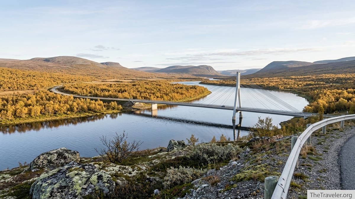
Other Key Attractions: Sámi Bridge, Churches and River Scenery
While Kevo draws serious hikers, many visitors experience Utsjoki through its rivers, villages and smaller-scale walks. One of the most striking man-made landmarks is the Sámi Bridge, a cable-stayed steel bridge completed in the early 1990s. It carries the E75 over the Teno River between Finland and Norway and has a main span of more than 150 meters. The bridge’s sweeping pylons and cables are visible from afar, especially in winter when snow and river ice accentuate its silhouette. Several lay-bys and small parking areas along the approach roads allow you to stop for photographs without blocking traffic.
On the Finnish side of the river, close to the village center, stands Utsjoki Church. Built of stone in the mid-19th century, it is one of the northernmost churches in Finland and forms part of a traditional church village with old log buildings. Historically, Sámi families would travel long distances with their reindeer to attend services and markets here several times a year. Today, the church is still in use and may open to visitors at scheduled times or during special events. Ask locally about opening hours, as they can vary with the liturgical calendar and community activities.
Further along the Teno valley and toward Nuorgam, you will find numerous small rest spots, riverside shelters and official fishing areas. In summer, the Teno has been renowned as one of the most important Atlantic salmon rivers in Europe. In recent years, however, salmon fishing regulations have tightened significantly in response to conservation concerns, and in some seasons fishing for salmon has been heavily restricted or stopped. If angling is central to your visit, always check the latest regulations on both the Finnish and Norwegian sides, as well as any permit requirements related to invasive species control, gear disinfection and species-specific quotas.
Even without fishing, the river landscape itself is a major attraction. In late summer and early autumn, birch forests along the valley turn vivid yellow against the blue river, while in winter the scene turns monochrome with snow-covered banks, frozen shallows and the occasional plume of mist rising from open leads. Short, well-trodden paths often lead from lay-bys down to the water, but in unmarked areas remember that river banks can be steep and slippery, especially in thaw periods when ice may be unstable.
Seasons, Weather and When to Visit Utsjoki
Utsjoki’s subarctic climate shapes almost every aspect of a visit. Winters are long, cold and dark, while summers bring the midnight sun and relatively mild temperatures. Roughly from early December to early January, the sun does not rise above the horizon at all, although daylight still lingers for a few hours each day as a deep blue twilight. From around late May to late July, the opposite occurs, with the sun staying above the horizon 24 hours a day and the sky glowing around the clock.
For many travelers, the prime hiking season runs from late June through September. By late June, most of the snow on the fells has melted, river levels have usually dropped to more manageable levels and trails in Kevo and other areas tend to be fully open. July can be surprisingly warm, with daytime temperatures occasionally climbing above 20 degrees Celsius, but it can also be wet, and mosquitoes can be intense in low-lying areas. By September, nights are cooler, insect numbers drop and autumn colors spread across the fells, making it a favorite time for photographers and long-distance hikers.
Winter draws visitors seeking snow, Northern Lights and quiet riverside cabins. From roughly September to April, the Northern Lights can appear on clear, dark nights, with the peak viewing period usually from late autumn through March. In midwinter, temperatures can fall below minus 20 degrees Celsius, and strong winds on exposed fells can make conditions dangerous for poorly equipped hikers. Many winter visitors focus on short activities such as snowshoe walks, cross-country skiing on local tracks or simply enjoying the polar night atmosphere near their accommodation rather than attempting multiday treks deep into the fells.
Spring and late autumn are shoulder seasons that require extra flexibility. In May, snowmelt can make smaller roads muddy and some hiking routes impassable because of swollen streams. In late October and November, there may be ice and darkness but not yet a reliable snowpack for winter activities. For these in-between months, it is important to check local information on trail conditions, road accessibility and whether seasonal services such as guided tours or accommodation are open or closed.
Culture, Sámi Heritage and Responsible Travel
Utsjoki is unique in Finland in that Sámi people form a majority of the local population. The main local language alongside Finnish is Northern Sámi, and you will see bilingual signs throughout the municipality. Visiting here offers an opportunity to learn about Sámi culture, crafts and contemporary life, but it is important to do so respectfully, recognizing that this is not an open-air museum but a living community. Where possible, choose tours, experiences and accommodation run by Sámi businesses, which helps support local livelihoods and ensures that cultural presentations reflect local perspectives.
Some small enterprises in and around Utsjoki offer cultural programs that may include traditional handicrafts, storytelling, joik singing or visits to reindeer herders. These experiences often need to be booked in advance, particularly outside the busiest winter weeks. When participating, ask permission before taking close-up photos of people, children or reindeer, and avoid sharing sensitive information such as the precise locations of reindeer calving grounds or private family gatherings on social media.
Respecting the environment is equally important. Large parts of Utsjoki are protected, and even outside formal reserves the land forms part of active reindeer herding districts. Following marked trails, keeping dogs on a leash and closing any gates you pass through all help to prevent disturbance to animals. In summer, walking off-trail across fragile lichen and tundra vegetation can leave scars that take years to heal. In winter, snowmobile and ski tracks are sometimes used by herders; if you join a snowmobile tour, riding only on approved routes and following guide instructions reduces the risk of disrupting herds.
When photographing the Northern Lights or night skies, be mindful of light pollution. Bright torches, headlamps and flash photography can disturb wildlife and other visitors seeking a dark, quiet experience. Many accommodations in Utsjoki are already careful about exterior lighting, using low, warm lights that minimize skyglow, so consider following their lead by shielding your own lights and using them sparingly.
The Takeaway
Planning a visit to Utsjoki involves more than just tracing a line on the map to Finland’s northern tip. Distances are long, weather is changeable and services are sparse compared with better-known Lapland destinations. But with good maps, up-to-date visitor information and realistic expectations about travel times and conditions, the rewards are significant: quiet river valleys, deep canyons, Sámi culture and some of the clearest Arctic light in Europe.
Start your trip planning by understanding the geography of Utsjoki, the structure of its villages and the limitations of local public transport. Use official sources for maps and regulations, especially if you aim to tackle the Kevo trails or fish along the Teno. Consider the season carefully, whether you want the midnight sun, autumn colors or polar night, and prepare equipment that matches the conditions rather than the calendar.
Above all, approach Utsjoki on its own terms. This is not a heavily packaged resort, but a sparsely populated borderland where nature, culture and everyday life intermingle. By traveling thoughtfully, supporting local Sámi-owned businesses and respecting both people and landscapes, you can make your journey to the far north memorable for the right reasons.
FAQ
Q1. How do I get to Utsjoki from Helsinki without a car?
Most travelers take an overnight or daytime train from Helsinki to Rovaniemi, then a long-distance bus to Ivalo and a connecting bus onward to Utsjoki. Because there is usually only about one suitable connection per day, check current timetables and buy your bus tickets in advance when possible.
Q2. Do I need a car to explore Utsjoki and Kevo Strict Nature Reserve?
A car is not essential but it makes trip planning much easier. Kevo trailheads and many viewpoints are not directly served by regular buses, and local taxis or transfers can be expensive over long distances. If you do not wish to drive, consider joining guided hikes or package tours that include transport.
Q3. When is the best time of year to hike in Kevo Strict Nature Reserve?
The main hiking season generally runs from mid-June to mid-October, with the most popular months being July, August and early September. In early summer, river crossings can still be challenging because of snowmelt, while in late September nights are colder but autumn colors are at their best.
Q4. Are there easy walking routes in Utsjoki for beginners?
Yes. While the multi-day Kevo and Guivi trails are demanding, there are shorter and easier walks near Utsjoki village and along the Teno River valley, including gentle riverside paths and low fells with marked viewpoints. Local tourist information can suggest routes suitable for your fitness level and the current conditions.
Q5. Can I see the Northern Lights in Utsjoki?
Utsjoki is well placed for Northern Lights viewing from roughly September to April, thanks to its northern latitude and relatively low light pollution. Clear, dark nights are key, so plan to stay several days if possible and be prepared for late-night or early-morning sky watching.
Q6. What kind of maps should I bring for hiking in the Utsjoki area?
For village walks and short excursions, simple local maps from the tourist office are usually enough. For longer hikes, especially in Kevo Strict Nature Reserve, bring a detailed topographic hiking map that shows trails, contour lines, huts and river crossings, and consider downloading official GPX tracks for use offline.
Q7. Are there shops and fuel stations in Utsjoki?
Utsjoki village has at least one grocery store and a fuel station, and there are additional services in nearby Norwegian settlements such as Tana Bru. However, options are limited compared with southern Finland, so fill your tank when you can and stock up on food before heading into remote areas or onto long hiking routes.
Q8. Is it possible to fish in Utsjoki as a visitor?
Yes, but regulations are strict and have changed in recent years, especially for salmon in the Teno River. Depending on the season, some species or areas may be off-limits or heavily restricted. Always check current rules and permit requirements on both the Finnish and Norwegian sides before planning any fishing.
Q9. What should I pack for a summer trip to Utsjoki?
Even in July and August you should pack layered clothing, a waterproof shell, hat and gloves, sturdy hiking boots, insect repellent and a sleep mask for the midnight sun. If you plan to hike in Kevo, bring a good backpack, trekking poles, a reliable map and navigation tools, and a tent and stove if you intend to camp.
Q10. How can I travel responsibly and support local Sámi communities?
Choose locally owned accommodations and tours, especially those run by Sámi entrepreneurs, follow local guidance on reindeer and land use, ask permission before photographing people, and stay on marked trails in protected areas. Spending money in local shops and buying authentic Sámi handicrafts from trusted sellers also helps sustain community livelihoods.