
If you are planning a trip to Bryce Canyon National Park, chances are you have already seen photos of the Queen’s Garden Trail: creamy orange hoodoos, narrow passageways and a path that seems to weave straight into a stone fairytale. This is the park’s classic “first hike” below the rim, but its popularity also means questions about maps, current trail conditions, parking, and how hard the climb back up really feels at 8,000 feet. This guide pulls together the latest official information and real-world examples so you can step onto Queen’s Garden prepared rather than guessing at the trailhead sign.
Get the latest updates straight to your inbox!
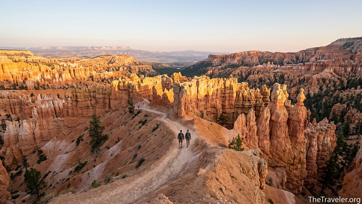
Where the Queen’s Garden Trail Is and What to Expect
Queen’s Garden is one of the main front-country trails in Bryce Canyon National Park in southern Utah, about a four-hour drive from Las Vegas or Salt Lake City. The trail starts at Sunrise Point on the rim and descends into the Bryce Amphitheater, the dense cluster of hoodoos visitors see in most postcards of the park. The route is considered the least strenuous of the six main trails that drop below the rim, but it is still a moderately challenging 1.8 mile out and back with about 450 feet of elevation gain on the return climb, according to the National Park Service. In practice that means most reasonably fit hikers take 1 to 2 hours to complete it at a comfortable pace.
From the rim, the path winds down a narrow ridge between fins of rock, passing through short tunnels and beneath walls of orange, peach and pink stone. At the lower end, a short spur leads to the Queen Victoria hoodoo, a rock formation locals love to point out as resembling a robed queen looking over a “garden” of smaller hoodoos. Many visitors treat this viewpoint as their turnaround point before re-ascending to Sunrise Point.
Because Bryce Canyon sits around 7,600 to 8,000 feet above sea level by the trailhead, the same 450-foot climb that might feel easy at sea level can feel surprisingly intense here. In early summer you will often see people who cruised down the descent now stopping every few switchbacks to catch their breath on the way back up. Plan your timing and expectations around this altitude effect, particularly if you are arriving straight from low elevation.
In busy seasons such as June and July, Queen’s Garden is often one of the most crowded trails in the park, with a steady flow of people starting soon after sunrise. That popularity is a double-edged sword: you have constant company and a well-trodden route that is easy to follow, but those hoping for solitude will need to time their hike carefully, often just after sunrise or late in the afternoon.
Maps, Signage and How to Navigate the Route
The good news for anyone worried about getting lost is that Queen’s Garden is one of the best signed and most straightforward hikes in Bryce Canyon. At Sunrise Point, a large National Park Service wayside display offers a top-down trail map and an elevation profile, along with accessibility information such as typical grade and width. Similar information appears in the park’s official 2024 visitor guide map, which marks Queen’s Garden as a 1.8 mile round trip from Sunrise Point, with its junctions to the Navajo Loop and Peekaboo Loop clearly indicated.
On the trail itself, brown post markers and junction signs make navigation intuitive. Shortly after you begin descending from Sunrise Point, you will pass small junction signs indicating connections to the Navajo Loop and the Figure 8 combination with Peekaboo. At the bottom, a spur sign points the way to the Queen Victoria hoodoo. In most conditions, visibility is excellent and the path is a beaten corridor of pale, dusty sediment wide enough for people to pass in both directions.
Despite the clear signage, carrying a map is still wise. The park newspaper and visitor guide, available free at the entrance station and visitor center, include a basic amphitheater map sufficient for day hikers. Travelers who want added detail often bring a Trails Illustrated Bryce Canyon map or print a topographic map that covers the Sunrise Point, Queen’s Garden, Navajo Loop and Peekaboo area. An offline-capable app on your phone can be useful, but treat it as a backup, since the steep walls can interfere with GPS and batteries drain faster in cold or very hot weather.
First-time visitors are sometimes surprised that Queen’s Garden is not a loop by itself. The pure out and back route simply goes from Sunrise Point down to Queen Victoria and then back up. The popular “loop” versions that many guidebooks describe, such as the 2.9 mile Queen’s Garden and Navajo combination or the longer Figure 8 that adds Peekaboo, all rely on junctions clearly shown on the maps. If you are following a specific loop described in a guidebook or on a hiking website, study how those junctions connect before you leave the rim so you recognize them when you see the signs.
Trail Conditions, Seasonal Closures and When to Go
Conditions on Queen’s Garden change with the seasons, and checking them just before you arrive is essential. The National Park Service maintains a current conditions page for Bryce Canyon and updates its trail status regularly, especially in winter and spring when freeze-thaw cycles and snowmelt can make slopes unstable. As of spring 2026, the park continues to treat Queen’s Garden as a year-round trail, but sections can close temporarily after storms or when icy conditions make the steep grades hazardous.
From late spring through early fall, the trail surface is usually dry, dusty and firm, with loose gravel on corners and switchbacks. In June, for example, you might leave Las Vegas at 90 degrees Fahrenheit and arrive at Bryce midday to find the amphitheater in the mid-70s, with high UV exposure. The dirt here is a pale orange that reflects light, so sunglasses and sun protection are as important as sturdy footwear. Afternoon thunderstorms are common in July and August; lightning risk is higher on the exposed rim than down in the hoodoos, so rangers will often suggest finishing rim viewpoints before storms build and starting hikes like Queen’s Garden early in the day.
In winter and early spring, snow and ice are the biggest factors. Even when main roads and parking areas are plowed, the trail can be covered in packed snow and refrozen meltwater, especially on shaded switchbacks. It is common for local outfitters and rangers to recommend traction devices such as microspikes for your boots during these months. Visitors arriving in February often underestimate this; more than one hiker has started down in regular running shoes, slid on the first icy turn and decided to turn back. In the worst freeze-thaw conditions, specific segments or adjoining routes such as the steep Wall Street side of Navajo Loop may close, which affects how you can combine Queen’s Garden with other trails.
Shoulder seasons like late May or late September usually offer the best combination of conditions and crowd levels. Daytime highs are often in the 60s or low 70s Fahrenheit, snow is largely gone from the trail, and the most intense summer crowds have not yet arrived or are tapering off. In these windows, hikers report being able to find parking at Sunrise Point mid-morning and sharing the trail with others without feeling like they are in a line.
Access, Parking, Shuttles and Fees
Reaching Queen’s Garden starts with getting to Bryce Canyon National Park itself. The park charges a per-vehicle entrance fee that is valid for seven days, with slightly lower per-person fees if you arrive on foot, bicycle or motorcycle. Many frequent park visitors instead purchase an America the Beautiful annual pass, which covers entrance to Bryce and most other major national parks for one year. Once inside Bryce, follow the main park road to the signed turnoff for Sunrise Point, which is just beyond the lodge and a short drive from the visitor center.
Parking at Sunrise Point is limited, and in peak months it commonly fills by mid-morning. The park’s seasonal shuttle system, operating roughly from spring through fall, is often the easiest way to reach the trailhead in busy periods. Shuttles stop at the visitor center, major lodges and viewpoints including Sunrise and Sunset Points. The ride from the visitor center to Sunrise Point typically takes less than 15 minutes, and many visitors simply leave their car at their hotel in Bryce Canyon City and board a shuttle directly.
For example, a family staying at a motel just outside the park might board a morning shuttle around 8:30, get off at Sunrise Point ten minutes later, hike Queen’s Garden and the connecting Navajo Loop in two and a half hours, then catch another shuttle to Inspiration Point before returning to their car in the afternoon. By relying on the shuttle, they avoid circling parking lots and can adjust their plans easily if one trail or viewpoint seems crowded.
Oversized vehicles such as large RVs can face restrictions at Sunrise Point when the shuttle is in operation, so those drivers should check seasonal rules before arrival and strongly consider using the shuttle instead of trying to park at the rim. Regardless of vehicle type, it is wise to arrive early in the day, both for parking and to take advantage of cooler temperatures and calmer weather conditions.
Difficulty, Safety and What to Pack
On paper, Queen’s Garden looks like a moderate, manageable hike, and for many people it is. Yet the combination of altitude, sun exposure and a steady climb back to the rim can still surprise visitors who are not used to hiking, especially those arriving from lower elevations. The trail’s average grade is around 11 percent, with short stretches as steep as 25 percent; going down, that can feel deceptively easy. Coming back up, it becomes a lung-burner for anyone not paced properly.
To stay safe and comfortable, treat the hike as you would a longer mountain trail. Carry at least one liter of water per person on cool days and more in summer, along with salty snacks to keep your energy up. Rangers frequently see visitors start late in the morning with only a small bottle of water and no hat; by early afternoon, some of those hikers are overheated and flagging badly on the final switchbacks. Even in May, UV exposure at 8,000 feet can be intense, so sunblock, a brimmed hat and sunglasses are basic essentials.
Footwear should have a solid tread and closed toes. The surface is a mix of packed dirt and loose grit, and it is common to see people slip slightly on ball-bearing-like pebbles if they are wearing smooth-bottomed sneakers or sandals. In winter or early spring, simple slip-on traction spikes over your shoes can make the difference between a cautious but comfortable descent and a nerve-wracking slide. Hiking poles are optional but helpful, especially for anyone with knee issues or concerns about balance on the descent.
Finally, be realistic about medical conditions and group abilities. People with heart or lung issues, or those not acclimated to altitude, should start slowly and be willing to turn around earlier than planned. Families with young children often find that the novelty of the hoodoos keeps kids engaged on the way down, but those same children can become tired and cranky on the uphill return. Building in time for frequent breaks, especially in shaded pockets along the trail, makes the experience more enjoyable for everyone.
Combining Queen’s Garden with Other Bryce Canyon Trails
One of the best features of Queen’s Garden is how easily it links with other classic Bryce Canyon routes. The most popular combination is the Queen’s Garden and Navajo Loop, a roughly 2.9 mile trek that descends from Sunrise Point on Queen’s Garden, traverses the canyon floor, then climbs back up to Sunset Point via the Navajo Trail. A short, mostly flat walk along the rim between Sunrise and Sunset then completes the loop. For most visitors of average fitness, this combination takes around 2 to 3 hours with photo stops.
Within the Navajo Loop, there are two main branches: the Wall Street side and the Two Bridges side. Park managers sometimes close the steep, narrow Wall Street segment in winter or early spring due to ice and rockfall risk, while leaving Two Bridges open. In such cases, hikers can still do a partial “lollipop” loop by going down Queen’s Garden, crossing the floor of the amphitheater, ascending via Two Bridges, and walking the rim back to Sunrise. Rangers at the visitor center will usually highlight on a map which segments are open on any given day.
For more experienced hikers, Queen’s Garden can also be part of the longer Figure 8 combination, which adds the Peekaboo Loop to create a roughly 6.4 mile route with substantial elevation changes. This option typically takes 4 to 5 hours and offers extended time close to classic formations such as the Wall of Windows and the Cathedral. Local guides often describe the Figure 8 as the best single-day sampler of Bryce’s main amphitheater for fit, prepared visitors.
If you have only half a day in Bryce, combining Queen’s Garden with Navajo Loop is usually the most efficient use of your time. It offers close-up hoodoos, shaded slot-like sections and wide amphitheater views, all within a reasonably short distance. Travelers with a full day or multiple days can then layer on other hikes such as the Rim Trail between Sunrise and Inspiration Points, the Fairyland Loop, or shorter strolls like the Bristlecone Loop at the far end of the park road.
Practical Tips from Real Visitor Experiences
Visitor reports and ranger observations offer a few consistent, practical lessons that do not always make it into glossy brochures. One common theme is the value of an early start. Hikers who begin Queen’s Garden around sunrise often describe a quiet trail with soft, angled light catching the hoodoos and a much cooler climb out. By contrast, those who start late morning in July often find themselves in a continuous stream of people and direct overhead sun, which washes out colors in photos and raises the effort level.
Another recurring piece of feedback is that the uphill feels longer than expected. Even active travelers who regularly jog at sea level note that they need more breaks on the final third of the climb than they would on a similar trail back home. This is not a sign that you are out of shape so much as a reminder of Bryce’s altitude. Building an extra 15 to 20 minutes into your schedule for the return leg helps reduce stress if you are trying to make a shuttle or a timed reservation elsewhere later in the day.
Families also highlight how important it is to manage expectations with children. Many parents find success by making a game of spotting shapes in the hoodoos, such as castles, animals or faces, to keep kids engaged. Several report turning around even before the official Queen Victoria spur when they notice energy levels dipping, choosing a shady alcove for a snack and then heading back up while everyone is still in good spirits instead of pushing to the absolute end of the trail.
Finally, weather flexibility is essential. Visitors who adjust their plans based on the daily forecast tend to have better experiences. For example, if afternoon thunderstorms are predicted, it often makes sense to hike Queen’s Garden early, spend midday exploring the visitor center and scenic overlooks by car or shuttle, and then return to the rim for sunset when storms have passed. Conversely, if a cold front brings ice to the trail surface, swapping a below-the-rim hike for a shorter, safer rim walk until conditions improve can prevent a vacation-ending injury.
The Takeaway
Queen’s Garden Trail is popular for good reason. It offers an accessible yet adventurous way to step down among Bryce Canyon’s signature hoodoos without committing to an all-day trek. With clear maps, well-marked junctions and reliable shuttle access, it is an ideal first hike in the park for many visitors, provided they respect the altitude, weather and steepness of the climb back to the rim.
Preparing for the trail means more than just glancing at a social media photo. Checking up-to-date conditions through official park channels, picking up a current visitor guide map, planning your timing around parking and shuttles, and packing water, sun protection and appropriate footwear can transform the experience from a rushed box-checking exercise into a highlight of your trip. Combined thoughtfully with neighboring routes such as Navajo Loop, Queen’s Garden can anchor a memorable day exploring the Bryce Amphitheater.
Whether you are road tripping southern Utah’s “Mighty Five” parks or making a dedicated visit to Bryce Canyon, setting aside a few hours for Queen’s Garden is a choice few travelers regret. Approach it with realistic expectations, a flexible plan and a sense of curiosity, and the garden of stone queens and castles below Sunrise Point will reward you with some of the most distinctive vistas in the American Southwest.
FAQ
Q1. Where does the Queen’s Garden Trail start?
The trail begins at Sunrise Point in Bryce Canyon National Park. A large wayside sign at the overlook provides a map, description and basic safety information.
Q2. How long does it take to hike Queen’s Garden?
Most visitors complete the 1.8 mile out and back in 1 to 2 hours, depending on fitness, altitude adjustment, photo stops and whether they continue onto connecting trails.
Q3. Is Queen’s Garden suitable for beginners?
Yes, for many people it is a good first hike below the rim, but it is still moderately strenuous. The main challenge is the steady 450-foot climb back up to the rim at high elevation.
Q4. Can I hike Queen’s Garden in winter?
Often yes, but conditions vary. Snow and ice are common on the trail, and traction devices may be necessary. Parts of nearby routes like the Wall Street section of Navajo Loop may close seasonally.
Q5. Are there maps available at the trailhead?
Yes. The Sunrise Point wayside shows a detailed schematic of the Queen’s Garden route and its junctions. The park visitor guide also includes a current amphitheater map you can carry.
Q6. Do I need a reservation or permit to hike Queen’s Garden?
No advance hiking permit is required for this trail. You only need to pay the standard Bryce Canyon entrance fee or hold a valid interagency pass.
Q7. Is the Queen’s Garden and Navajo Loop combination much harder?
It is longer and adds more elevation change, but many reasonably fit visitors complete the 2.9 mile combination in 2 to 3 hours. The climb out via Navajo can feel steeper than returning the same way on Queen’s Garden.
Q8. Is the trail appropriate for young children?
Many families hike Queen’s Garden with children, but parents should supervise closely near drop-offs and be prepared for kids to tire on the uphill. Turning around early is always an option.
Q9. Are pets allowed on Queen’s Garden?
No. Pets are not permitted on this trail. Service animals that meet the legal definition are allowed in national parks, but regular pets must stay on designated pet areas.
Q10. What is the best time of day to hike Queen’s Garden?
Early morning or late afternoon usually offer cooler temperatures, softer light and slightly smaller crowds. Midday can be hot and bright, especially in summer.