
Comb Ridge rises in a dramatic sandstone wave above the desert between Bluff and Blanding in southeastern Utah, its canyons sheltering thousand-year-old dwellings, rock art panels and seasonal springs. For hikers, it offers a mix of short, family-friendly walks to signed overlooks and more adventurous, off-trail scrambles into quiet side canyons. For the region’s Native communities, it is a living cultural landscape. If you are planning a trip focused on hiking routes, ancient ruins and petroglyphs, you will need more than a map. You will also need a solid grasp of permits, access roads and etiquette so that your visit helps protect a fragile place that is seeing steadily increasing use.
Get the latest updates straight to your inbox!
Understanding Comb Ridge and Its Setting
Comb Ridge is a long sandstone monocline running roughly north to south for about 80 miles across the high desert of southeastern Utah and into northeastern Arizona. From the air it looks like a serrated backbone, with tilted layers of Navajo and Wingate sandstone forming a steep western face and gentler eastern slopes drained by Butler Wash. Drivers on U.S. Highway 163 west of Bluff see the ridge as a jagged wall on the horizon; Highway 95 later crosses it again between Blanding and Natural Bridges National Monument.
The section most hikers explore lies inside Bears Ears National Monument, in the Shash Jáa unit, where short canyons cut into the east side of the ridge. Here, shallow alcoves and ledges hide granaries, cliff dwellings and rock art left by ancestral Puebloan peoples. Many of the better-known sites sit just a few miles west of dirt roads like Butler Wash Road, often reached by short routes across slickrock and sandy benches. The landscape feels wild, but it is not remote in the way of deeper Cedar Mesa canyons. Day hikers can base themselves in Bluff or Blanding and reach most trailheads in 30 to 60 minutes of driving.
Management is shared between the Bureau of Land Management and the U.S. Forest Service through Bears Ears National Monument, with Comb Ridge itself primarily on BLM land. That means use rules, fees and camping regulations are defined not by a single national park style entrance gate but by a patchwork of monument-wide policies. Before you lace up your boots, it is worth taking a few minutes to understand how access, permits and cultural protections work here today.
Access, Permits and Current Regulations
Day hiking in the Cedar Mesa and Comb Ridge portions of Bears Ears National Monument now requires a day hiking pass, which you can typically obtain through recreation permit systems managed by the Bureau of Land Management or at on-the-ground outlets in Bluff and Blanding. As of mid 2026, fees for these passes are modest on a per-person basis, but structures have evolved in recent years as visitation has climbed. It is safest to check current prices and purchase options just before your trip, as updates are issued periodically, especially at the start of spring and fall hiking seasons.
The fee area has expanded over time to include Butler Wash and Comb Ridge in the Shash Jáa unit, which means that even shorter walks to petroglyph panels or alcove ruins off Butler Wash Road are usually subject to the same permit rules as longer canyon hikes on Cedar Mesa. In practice, this means that a family heading out for a half-day hike to a site like Procession Panel should expect to have passes sorted in advance, either printed or available digitally, and to carry them on the trail in case of ranger contact.
Camping regulations distinguish between designated campgrounds and dispersed sites. Comb Wash and Sand Island campgrounds, both near the southern end of the monument, are commonly used bases for exploring Comb Ridge. They generally offer vault toilets and basic picnic setups but no hookups or showers, and sites operate on a first-come, first-served basis much of the year. Dispersed camping is allowed along many dirt roads, including parts of Butler Wash and Comb Wash, provided you stick to previously disturbed clearings and comply with current fire restrictions. However, managers have been studying ways to concentrate camping in fewer, hardened locations to protect cultural resources, so expect rules to continue evolving.
Pets are allowed in many parts of Bears Ears, but some nearby canyons in the Cedar Mesa area have specific dog restrictions. Around Comb Ridge itself you can usually hike with a leashed dog on established approaches, but you should always confirm your exact route against the latest BLM guidance. Regardless of formal rules, it is critical to keep pets away from ruins and rock art and to pack out pet waste along with your own trash.
Getting There: Roads, Trailheads and Conditions
The main access corridor for the eastern side of Comb Ridge is Butler Wash Road, a mostly graded dirt track that parallels the ridge from just west of Bluff on U.S. Highway 163 north to State Route 95 west of Blanding. In dry conditions, a standard clearance passenger car can usually handle the road, although shallow wash crossings can be rutted and rough. After heavy rain or snow, clay sections quickly turn slick and may become impassable, so a high-clearance or four-wheel-drive vehicle gives you a wider margin of safety.
Most hiking routes to ruins and rock art start from unsigned or minimally signed pullouts along Butler Wash Road. For example, the trail to Procession Panel leaves from a small parking area on the west side of the road, then crosses open slickrock toward the base of the ridge. Other popular routes, like those to Monarch Cave or Double Stack Ruin, similarly begin from rough side tracks or simple dirt clearings. This patchwork of informal access means that a reliable, up-to-date map or offline navigation app is essential. Many hikers use BLM-produced trip planner PDFs in combination with commercial mapping apps that mark known trailheads and canyon mouths.
If you plan to explore the western side of Comb Ridge, where Comb Wash cuts along the base of the cliffs, access is via a different set of dirt roads branching off Highway 95 or Highway 163. Conditions here vary significantly by season, with crossings occasionally flooded in spring or after monsoon storms. Some primitive roadside campsites under cottonwoods near Arch Canyon or along Comb Wash give early risers a head start into nearby drainages. Always check the weather forecast before committing to low-lying roads, and be prepared to turn around if wash crossings look deeper or swifter than expected.
Cell coverage is limited across most of the ridge. In practical terms, that means downloading maps ahead of time, sharing your route plan with someone back home and carrying basic emergency gear. You will pass through the small towns of Bluff or Blanding on your way in; use these as last-chance stops for fuel, drinking water and groceries since there are no services along Butler Wash or in Comb Wash.
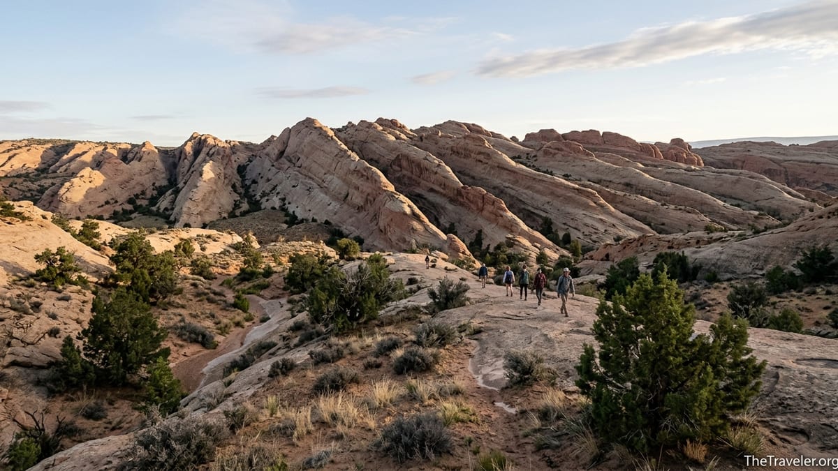
Signature Comb Ridge Hikes and Ruin-Focused Routes
Although guidebooks and online trip reports list dozens of individual hikes along Comb Ridge, most visiting hikers focus on a handful of classic routes on the east side. One of the best known is the hike to Procession Panel, a long petroglyph frieze showing rows of small human figures that many interpret as a ceremonial or migratory procession. From the Butler Wash trailhead, the route follows faint paths across sandstone, weaving through juniper and slickrock for roughly a couple of miles one way. The final approach involves traversing a sloping bench beneath the cliff band to reach the panel, which sits high on a vertical face with expansive views back toward the wash.
Another standout is Monarch Cave, an alcove ruin set at the head of a short canyon that cuts into the ridge. The trail begins from Butler Wash Road and follows the sandy wash bottom before climbing slickrock slabs into the canyon. Hikers encounter pottery sherds and rock art along the way, along with a small pool or seep at the head of the drainage during wetter periods. The ruin itself occupies a deep, shaded recess, with masonry rooms built against the back wall and a talus slope leading up from the canyon floor. Exploring here requires careful footing and strict adherence to “look but do not touch” ethics.
Other frequently visited destinations include Double Stack Ruin, Fishmouth Cave and various cliff dwellings collectively referred to as the Butler Wash ruins. Trail lengths vary from less than a mile round trip for simple overlooks to half-day explorations that link multiple sites in a single outing. Many routes are not formally signed, and social paths sometimes braid across open rock. That makes route-finding part of the challenge and the appeal. It also increases the importance of having clear turnaround times, extra water and enough daylight to correct for a wrong turn without pressure.
On the western side of Comb Ridge, off Comb Wash Road, hikers can access different sets of ruins tucked into alcoves overlooking seasonal streams and cottonwood groves. These drainages are less documented in mainstream guidebooks, and many visitors choose to hire a local guide or join a small-group tour to explore them, both for navigation support and for deeper cultural context. Whether you go independently or with a guide, remember that scrambling up slopes to reach ruins is often discouraged or prohibited, especially where climbing gear would be required. Many of the most sensitive alcoves are meant to be viewed from a respectful distance on the canyon floor.
Rock Art, Ancient Dwellings and Visiting with Respect
Comb Ridge is particularly rich in rock art. In addition to Procession Panel, hikers encounter petroglyphs near Butler Wash ruins, along the San Juan River corridor and in smaller alcoves scattered under the cliffs. Panels may include geometric shapes, spirals, animals and human forms, pecked or incised into the varnished sandstone. These images can be over a thousand years old, and they continue to hold cultural and spiritual significance for contemporary Native communities tied to this landscape.
Cliff dwellings here often date from the late ancestral Puebloan period, with masonry rooms tucked under overhangs and granaries perched on ledges just above the canyon floor. Typical features include stacked sandstone blocks bonded with mud mortar, small doorways, smoke-blackened ceilings and storage nooks sealed with flat stones. In some places you may see corn cobs, tool fragments or pottery sherds lying on the surface. The most important rule is simple: take only photographs, and leave everything you find exactly where it lies. Even picking up a pot sherd to examine it and setting it back down in a different spot can disturb the site’s story and accelerate erosion.
In recent years, land managers have emphasized a “visit with respect” message. That means staying on durable surfaces, never entering rooms or climbing onto walls, and giving rock art panels a wide berth. Oils from your fingertips can damage the natural patina that makes the art visible, and etching new names, chalking images or making rubbings are all considered vandalism and federal crimes. Many panels now show modern scratches and bullet damage alongside ancient motifs, a sobering reminder that individual actions have long-term consequences in such a fragile environment.
For many visitors, the most meaningful experiences at Comb Ridge come from slowing down. Instead of trying to tick through every named ruin in a single day, pick one canyon and sit quietly under the cottonwoods or in the shade of a cliff. Listen for ravens, watch how the light shifts on the sandstone and remember that people lived here, farmed here and raised children here centuries before the modern highway network made day trips possible. Approaching each site with humility and curiosity transforms the hike from a treasure hunt into a more thoughtful encounter with deep time.
Seasonal Considerations, Safety and Logistics
The most comfortable hiking seasons on Comb Ridge are spring and fall, roughly March through early May and late September through October, depending on snowmelt and the onset of winter storms. Daytime highs then are generally mild, and nights are cool but not bitterly cold. Summer is hot, often with intense sun reflecting off pale slickrock, and afternoon monsoon storms in July and August can raise flash-flood risk in narrow drainages. Winter can bring snow and ice on north-facing slopes and make clay roads treacherous, though crisp, clear days in December or January can still reward prepared hikers with solitude.
Water availability is highly variable. A few canyons hold seeps or pools well into the dry season, especially near spring-fed alcoves, but hikers should never count on finding drinkable water along the trail. Carrying at least three to four liters per person for a half-day outing is common practice in hotter months, along with high-calorie snacks and sun protection. A wide-brimmed hat, long-sleeved sun shirt and lip balm are as important as boots and trekking poles for many visitors.
Navigation deserves special attention. While some approaches follow obvious sandy washes, others traverse featureless slickrock benches where cairns may be sparse or misleading. A combination of paper map and GPS track usually works best. Many hikers load GPX files from reputable guide sources into devices or smartphone apps, then cross-check them against topographic maps. Because many cultural sites are not individually signed and some are intentionally omitted from public maps, you should expect a bit of uncertainty. If you find yourself cliffed out or facing a scramble that feels beyond your comfort level, turn around and search for a safer route rather than forcing the line.
Finally, remember that this is still remote canyon country. Even on popular weekends, you might not see another group on a given trail. Simple precautions like carrying a basic first-aid kit, an emergency bivy sack, extra layers and a headlamp can turn an inconvenience into a non-event if a hike takes longer than expected. Before you leave Bluff or Blanding, check in with local visitor centers or guide services for the latest word on road washouts, fire restrictions and permit updates. Conditions in desert landscapes can change quickly, and on-the-ground advice is often more current than any printed guidebook.
Where to Stay and How to Structure Your Comb Ridge Trip
Most visitors exploring Comb Ridge base themselves in one of three places: Bluff, Blanding or primitive campsites along Comb Wash and Butler Wash. Bluff, a small community along the San Juan River, offers a handful of locally owned motels, small inns and casitas along with a couple of sit-down restaurants and cafes. It is especially convenient for exploring the southern trailheads along Butler Wash Road and for combining hikes with visits to Sand Island’s rock art or San Juan River viewpoints.
Blanding is larger and sits roughly 25 to 40 minutes north of many Comb Ridge access points. It has more options for chain motels, grocery shopping and fuel, making it a practical base for multi-day trips that mix Comb Ridge hikes with visits to Natural Bridges National Monument, Mule Canyon ruins or the broader Cedar Mesa region. From Blanding, Highway 95 quickly delivers you to the northern segment of Butler Wash Road or across the ridge into Comb Wash.
For those who prefer to sleep under the stars, designated campgrounds at Comb Wash and Sand Island provide simple sites with vault toilets near the heart of the action. Dispersed roadside camping along Butler Wash and other dirt tracks is still available in many areas, though you should be prepared for evolving restrictions as managers respond to vegetation damage and cultural site impacts. In practice, that means choosing sites that are obviously previously used, avoiding camping within sight of ruins or rock art and using portable toilets or human waste bags when soil conditions make cat holes inappropriate.
A practical itinerary for a three-day visit might start with a warm-up hike to a moderately known alcove ruin from Butler Wash Road on day one, followed by an early-morning trip to Procession Panel on day two to beat the heat and crowds. Day three could be reserved for a more exploratory outing on the west side of the ridge or a day trip north to Cedar Mesa trailheads. Many travelers also weave Comb Ridge into a broader “Trail of the Ancients” style road trip that includes Hovenweep National Monument, Monument Valley Navajo Tribal Park and the scenic drive across Cedar Mesa, creating a week-long circuit of ancestral sites and desert landscapes.
The Takeaway
Comb Ridge is one of the most accessible places in southeastern Utah to walk among cliff dwellings, granaries and rock art while still feeling the quiet of the high desert. Its network of short canyons off Butler Wash Road and Comb Wash offers something for many hiking styles, from casual strolls to longer cross-country days linking multiple drainages. Yet this same accessibility, combined with growing visibility for Bears Ears National Monument, has put pressure on fragile sites that endured for centuries before modern visitation.
If you treat permits and regulations as part of the experience rather than an inconvenience, plan thoughtfully around season and weather, and approach each ruin and panel as a place of living significance rather than a backdrop for social media, you can help ensure that Comb Ridge remains a place of discovery for future travelers. Book lodging or secure camping early during peak seasons, carry more water and navigation tools than you think you will need and leave each site looking exactly as you found it. In doing so, you join a longer story of people moving carefully through these canyons, leaving only faint footprints in the sand beneath the sandstone spine of the ridge.
FAQ
Q1: Do I need a permit to hike at Comb Ridge?
Yes. Day hiking in the Comb Ridge and Cedar Mesa areas of Bears Ears National Monument generally requires a day hiking pass issued through the Bureau of Land Management permit system, so you should confirm current rules and obtain passes before heading to the trailhead.
Q2: What is the best time of year to visit Comb Ridge for hiking?
Spring and fall are typically best, with more comfortable daytime temperatures and fewer thunderstorms. Summer can be very hot with strong sun, while winter brings cold nights, possible snow and muddy roads that can limit access.
Q3: Can I visit ruins and rock art on my own, or do I need a guide?
You can visit many Comb Ridge sites independently as long as you have the appropriate permits and navigation tools, but hiring a local guide can add cultural context, improve safety and help ensure your visit follows best practices for visiting sensitive archaeological areas.
Q4: Are dogs allowed on Comb Ridge hikes?
Leashed dogs are allowed in many parts of Bears Ears, including some routes near Comb Ridge, but specific nearby canyons have pet restrictions. Always check the latest BLM guidance for your chosen trail and keep dogs away from ruins, rock art and cryptobiotic soil.
Q5: What kind of vehicle do I need for Butler Wash Road?
In dry conditions, much of Butler Wash Road is passable in a standard-clearance vehicle, though wash crossings may be rutted. After rain or snow, clay sections can become very slick, so high-clearance or four-wheel drive is recommended if conditions are uncertain.
Q6: How long are typical hikes to major sites like Procession Panel or Monarch Cave?
Many classic hikes on the east side of Comb Ridge, such as Procession Panel or Monarch Cave, are half-day outings for most hikers, often a few miles round trip. Distances and difficulty vary, so consult recent route descriptions and plan conservatively if you are new to desert hiking.
Q7: Is there drinking water available on the trails?
Water sources in Comb Ridge canyons are unreliable and often seasonal. You should plan to carry all of the drinking water you need for the day, typically several liters per person, and treat any natural sources as a backup rather than a guarantee.
Q8: Can I camp near ruins or rock art panels?
No. Camping close to archaeological sites is strongly discouraged and may be restricted. Choose previously used campsites well away from ruins and panels, use established campgrounds where provided and follow current dispersed camping guidelines.
Q9: How can I help protect archaeological sites while visiting?
Stay on durable surfaces, avoid entering rooms or climbing on walls, never touch rock art, leave artifacts exactly where you find them and pack out all trash and waste. Following these simple steps greatly reduces your impact on fragile sites.
Q10: Are there services or facilities at Comb Ridge trailheads?
Most Comb Ridge trailheads along Butler Wash and Comb Wash have minimal or no facilities. You should not expect water, restrooms or trash cans at most access points, so plan to use services in Bluff or Blanding and to be fully self-sufficient once you leave pavement.