
Rim views, quiet canyons and classic Bryce Canyon hoodoos make the Fairyland Loop Trail one of the park’s most rewarding full-day hikes. At roughly 8 miles with close to 1,700 feet of elevation change, it is a strenuous but achievable adventure for prepared hikers, and it helps you escape the crowds around the main amphitheater. This guide brings together the latest information on maps, current conditions and visitor logistics so you can plan a safe and memorable day on the Fairyland Loop.
Get the latest updates straight to your inbox!
Fairyland Loop Trail at a Glance
The Fairyland Loop is a roughly 8 mile loop hike in Bryce Canyon National Park that combines stretches along the Rim Trail with long descents and climbs through Fairyland and Campbell Canyons. Official National Park Service descriptions list the loop at about 8.0 miles with around 1,700 to 1,900 feet of cumulative elevation gain, depending on where you start and which map you consult. In practice, most hikers report 7.8 to 8.5 miles recorded on GPS watches.
This is considered a strenuous hike because of both length and elevation. Bryce Canyon’s rim sits around 8,000 feet above sea level, and much of the climbing happens on the way back out of the canyon. Even fit hikers who are used to sea level trails notice the thinner air. Plan on 4 to 5 hours of hiking time if you are moving steadily with short photo stops, and closer to 6 hours if you like to linger at viewpoints.
The loop can be started from two main access points: Fairyland Point at the north end of the main scenic drive, and the Tower Bridge trailhead just north of Sunrise Point along the Rim Trail. Either direction is possible, but rangers and many recent trip reports tend to recommend hiking counterclockwise from Fairyland Point or Sunrise Point because the climbs feel a bit more gradual and views of Boat Mesa and the hoodoos unfold more dramatically.
Unlike the park’s shorter routes such as Queen’s Garden or the Navajo Loop, the Fairyland Loop stays relatively quiet even at busy times of year. That solitude is a major part of its appeal, especially in 2026 while portions of the Navajo Loop have periodic closures after mudslides and rockfall. Hikers looking for a serious day hike with fewer crowds will often choose Fairyland Loop as their centerpiece experience in Bryce Canyon.
Finding and Using Reliable Maps
For a first-time visit, start with official maps produced by Bryce Canyon National Park. The free paper park newspaper handed out at the entrance station and visitor center includes a simplified hiking map with the Fairyland Loop clearly marked, elevation information and approximate hiking times. The National Park Service website also offers an online map that highlights the loop, Rim Trail and connections at Fairyland Point and Sunrise Point.
Because cell service around Fairyland Point and in the canyon is patchy, it is wise to carry at least one offline-capable map as a backup. Many visitors download the area inside a mapping app before arrival. Common choices include Gaia GPS, AllTrails and similar platforms, which offer topographic base layers and user-recorded GPX tracks for the Fairyland Loop. For example, a recent GPX track in popular hiking apps shows the loop at about 8.2 miles starting and ending at Sunrise Point, with the lowest point around 7,100 feet.
If you prefer paper maps with more detail than the free handout, look for the waterproof topographic maps sold at the Bryce Canyon Visitor Center bookstore or the general store near Sunrise Point. These maps, typically in the range of 15 to 20 dollars, cover the entire park trail network, including contour lines for Fairyland Canyon, Campbell Canyon and the rim. They are especially useful if you are combining Fairyland Loop with other rim hikes or planning backcountry excursions elsewhere in the region.
On the ground, the Fairyland Loop is generally well signed at major junctions, but it is not as intensively marked as the busiest amphitheater trails. Junction posts indicate directions to Fairyland Loop, Rim Trail, Tower Bridge, Sunrise Point and Fairyland Point. In dry, clear weather, experienced hikers rarely have trouble following the path. After fresh snow or heavy rain, however, sections can become indistinct, which is another reason a physical or offline digital map is worth carrying even on a straightforward loop.
Trail Conditions in 2026
As of mid 2026, the National Park Service continues to classify the Fairyland Loop as a strenuous front-country hike that can be affected seasonally by snow, ice, and monsoon storms. Bryce Canyon typically sees significant snowfall in winter, and official guidance notes that Fairyland Point road is not plowed during the snowiest months. In many winters this road is instead groomed for cross-country skiing, and access to the Fairyland Loop from that end may be closed to regular vehicle traffic until late spring.
During late spring, summer and early fall, the loop is usually snow free but can be affected by thunderstorms, especially in the July through early September monsoon period. Short but intense afternoon storms can bring heavy rain, hail and lightning. Rangers frequently advise hikers to start earlier in the morning so that they are back on higher, more exposed rim sections before typical storm times after lunchtime. After very wet periods, some clay-rich segments of the trail can become slick and muddy, and there may be temporary advisories for washouts or minor rockfall.
Recent seasons have also brought intermittent closures or restrictions on other Bryce Canyon trails, such as the Navajo Loop, due to mudslides and rockfall events. That has nudged more hikers onto alternative routes including Fairyland Loop. While the loop remains open and in good condition most days, you may notice slightly higher use than historical averages on peak weekends and holidays. Even then, many visitors still report long stretches of hiking with only a few other groups in view, especially in the farther reaches of Campbell Canyon.
Before setting out, check the latest conditions at the Bryce Canyon Visitor Center, which opens daily and posts current updates on trail status, closures and weather. Conditions can change quickly at this high elevation, and an open trail in the morning could see temporary warnings after an afternoon storm system. Ask rangers specifically about Fairyland Loop snow and mud conditions if you are visiting in shoulder seasons such as late April or late October.
Access, Parking and Shuttle Logistics
One of the most important planning details for the Fairyland Loop is access to your chosen trailhead. Fairyland Point lies at the northern end of the main park road, just beyond the fee stations and the Visitor Center. A short side road leads to a parking area positioned right on the rim. This lot is relatively small and fills quickly on busy summer days, especially given that oversized vehicles are often allowed here when other lots are restricted. There is no park shuttle service to Fairyland Point, so you must drive or walk there from elsewhere in the park.
The other common starting point is near Sunrise Point. During the shuttle season, typically running from spring through fall, park shuttles stop at the Visitor Center, Sunrise Point and other amphitheater viewpoints. While they do not go directly to Fairyland Point, many hikers ride the shuttle to Sunrise Point, access the Tower Bridge trailhead just north along the Rim Trail, then hike the loop and return to Sunrise Point or the nearby general store and lodge area at the end of the day. This option is especially convenient if you are staying at Bryce Canyon Lodge or the North Campground, as you can often leave your car parked and rely on the shuttle.
A common practical itinerary for 2026 might look like this: you park at the main shuttle station in Bryce Canyon City outside the park entrance around 7:30 in the morning, ride the first or second shuttle to the Visitor Center, transfer to a shuttle heading to Sunrise Point, and start hiking Fairyland Loop counterclockwise by about 8:15. After about 5 hours on the trail, including a long snack break near the midpoint, you return to Sunrise Point mid afternoon and catch a shuttle back to your car or lodging. This approach helps avoid parking stress at Fairyland Point and takes advantage of the free shuttle system that is designed to reduce congestion.
Whichever starting point you choose, remember that there is no water or restroom at Fairyland Point itself. The nearest seasonal water fill stations and restrooms are by the general store near Sunrise Point and at the Visitor Center. Many hikers fill up 2 to 3 liters of water per person before leaving that area and then drive to Fairyland Point or walk the rim to the Tower Bridge trailhead. Factoring these logistics into your morning routine helps you avoid discovering an empty water bottle at the trailhead.
What to Expect on the Trail
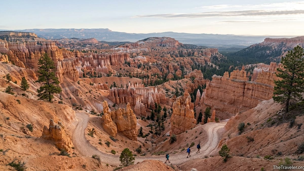
Hiking the Fairyland Loop counterclockwise from Fairyland Point, the trail immediately begins descending from the rim into Fairyland Canyon. Within the first mile, you are surrounded by classic Bryce hoodoos and formations with whimsical nicknames, including features often referred to as the Chinese Wall and various castles and towers. The descent is steady but not as steep or heavily switchbacked as the main Navajo trail; instead you wind gradually down the north side of Boat Mesa to the canyon floor.
Near the low point of the hike, around 7,100 to 7,200 feet, the trail traverses the bottom of Fairyland Canyon and then enters the more open terrain of Campbell Canyon. Here you trade tight clusters of hoodoos for more spaced-out formations, scattered ponderosa pines and sweeping views back to the rim. Many hikers note that this middle section can feel surprisingly quiet even on days when the amphitheater viewpoints above are packed with tour buses and crowding around railings.
As you proceed, the loop bends back toward the main Bryce Amphitheater, gaining and losing smaller amounts of elevation before a more sustained climb returns you to the rim near Sunrise Point or Fairyland Point, depending on your chosen route. The total ascent from canyon bottom to rim is on the order of 1,700 feet, but broken into segments so that you are alternating between moderate climbs and gentler traverses. In bright midday sun, this final stretch can feel challenging, especially for those not acclimated to the altitude.
Time estimates vary depending on fitness and photo habits. Active hikers who are comfortable with elevation often complete the loop in around 4.5 hours with short breaks. Families with teens or adults who like to stop frequently for photography and views commonly report 5 to 6 hours. Allowing a full half day in your itinerary avoids the pressure of racing the last climbs in late afternoon light or running short on water.
Safety, Gear and Seasonal Planning
Despite being a front-country hike, the Fairyland Loop demands respect. The combination of high elevation, significant ascent, and exposure to sun and weather means that underestimating the route can lead to dehydration or exhaustion. Each person should carry enough water for a 4 to 6 hour hike, which typically means at least 2 liters per person in cooler shoulder-season weather, and 3 liters or more in midsummer. Electrolyte tablets or powders are a good addition, particularly for visitors flying in from lower elevations such as Los Angeles or New York.
Footwear is another key consideration. The trail is generally well maintained but includes sections of loose gravel, packed dirt and the occasional rocky step. Sturdy hiking shoes or lightweight boots with good traction handle these surfaces far better than casual sneakers or sandals. Many hikers also find that collapsible trekking poles make the long descents and climbs noticeably easier on knees and ankles, especially when fatigue sets in late in the hike.
Seasonal gear choices matter as well. In summer, daytime highs on the rim can reach the 70s or 80s Fahrenheit, but the sun at 8,000 feet is intense. A wide-brimmed hat, sunglasses and broad-spectrum sunscreen are essential. In shoulder seasons, mornings can start near freezing even when afternoons are comfortable. Layering with a light insulated jacket or fleece, a windproof shell and moisture-wicking base layers allows you to adjust as temperatures swing during the day. In late fall or early spring, microspikes or traction devices may be useful if packed snow or icy patches remain in shaded areas.
Weather awareness is critical in all seasons. The exposed rim sections are vulnerable to lightning during storms, and the canyons can channel runoff from sudden downpours. Before leaving the trailhead, check the day’s detailed forecast at the visitor center or a reliable weather service. If dark clouds build and thunder is audible, the safest move is to shorten your loop by returning to the rim at the nearest junction rather than committing to another few miles deep in the canyon.
Combining Fairyland Loop with Other Bryce Experiences
For many travelers, the Fairyland Loop serves as the anchor activity in a one or two day stay at Bryce Canyon. Because it typically occupies about half a day, you can often combine the hike with scenic overlooks, a ranger program or a short stroll on another trail. A practical example: hike Fairyland Loop in the morning, have a late lunch near Sunrise Point, then drive the main park road in the late afternoon, stopping at viewpoints like Inspiration Point and Bryce Point for wide amphitheater vistas in softer light.
If you have two full days, consider a contrasting second-day hike such as the Queen’s Garden and Peekaboo Loop combination, often called the Figure Eight when Navajo segments are fully open. When parts of Navajo Loop are temporarily closed, rangers can suggest modified routes that still provide dramatic hoodoo scenery without duplicating the Fairyland experience. This allows you to experience both the quieter northern section of the park and the iconic central amphitheater below Sunset and Sunrise Points.
Travelers based in nearby Zion National Park often wonder whether they can fit Fairyland Loop into a day trip. It is technically possible, but demanding. For instance, a common plan might involve leaving Springdale around 6 in the morning, arriving at Bryce between 8:30 and 9, hiking Fairyland Loop for 5 to 6 hours, catching a sunset viewpoint, then driving back to Zion the same evening. That makes for a long day with significant driving and hiking, and it is best attempted only by well-prepared, energetic groups comfortable with high elevation exertion.
Families or more relaxed travelers may prefer to stay one night in or near the park. Lodging options include Bryce Canyon Lodge within the park, motels and cabins in Bryce Canyon City, and smaller inns along Highway 12. Staying closer reduces burnout and allows you to time the Fairyland Loop for the coolest part of the day, often starting between 7 and 8 in the morning in summer months.
The Takeaway
The Fairyland Loop Trail offers one of the most immersive and varied day hikes in Bryce Canyon National Park, with a blend of rim panoramas and quiet canyon solitude that many visitors rank alongside the park’s classic routes. At around 8 miles and nearly 1,700 feet of elevation change, it requires more commitment than the shorter amphitheater loops, but rewards that effort with fewer crowds and a sense of stepping into the wilder edges of Bryce’s hoodoo landscape.
Successful trips on the Fairyland Loop share a few common threads: hikers start early, carry adequate water and layers, rely on up to date maps and conditions from the National Park Service, and build enough time into their day to enjoy the formations without rushing. Whether you start at Fairyland Point or Sunrise Point, walk clockwise or counterclockwise, the loop showcases Bryce Canyon’s geology and high-country atmosphere in a way that feels both challenging and approachable.
With thoughtful planning around trail conditions, shuttle logistics and seasonal weather, the Fairyland Loop can be a highlight of a broader trip through Utah’s high plateau country. For many travelers, it becomes the hike they remember long after the trip ends: a half day spent winding among hoodoos, watching light shift across Boat Mesa and returning tired but satisfied to the rim.
FAQ
Q1. How long does it take to hike the Fairyland Loop Trail?
Most hikers take about 4 to 5 hours to complete the roughly 8 mile Fairyland Loop, though those who stop frequently for photos or breaks may spend closer to 6 hours on the trail.
Q2. What is the best direction to hike the Fairyland Loop?
Many hikers and rangers recommend hiking counterclockwise, either starting at Fairyland Point and descending into Fairyland Canyon or beginning at Sunrise Point and heading along the rim first, because the climbs feel more gradual and views unfold more dramatically.
Q3. Do I need a special permit to hike the Fairyland Loop?
No separate hiking permit is required for the Fairyland Loop. You only need to pay the standard Bryce Canyon National Park entrance fee, which can be covered by a day pass or an America the Beautiful annual pass.
Q4. Is the Fairyland Loop suitable for beginners?
The loop is considered strenuous due to its length, elevation change and high altitude. Fit beginners who are comfortable walking several miles and who pace themselves, carry sufficient water and start early can complete it, but those new to hiking may be better off starting with shorter trails first.
Q5. Can I hike the Fairyland Loop in winter?
Winter hiking is sometimes possible but highly variable. Snow and ice often cover the trail, the road to Fairyland Point may be closed to regular vehicles, and traction devices plus winter gear are essential. Always check with rangers for current winter conditions before attempting the loop.
Q6. Are dogs allowed on the Fairyland Loop Trail?
Dogs are not allowed on the Fairyland Loop or most backcountry-style trails in Bryce Canyon National Park. Pets are generally restricted to paved viewpoints, campgrounds and a few developed areas, so plan pet care before committing to this hike.
Q7. How much water should I carry for the hike?
There is no water available on the Fairyland Loop, so most rangers advise carrying at least 2 liters per person in cool weather and 3 liters or more per person in the hotter months, along with electrolytes if you are not used to high elevation exertion.
Q8. Is the trail well marked and easy to follow?
The main route is generally well defined and key junctions have signs pointing toward Fairyland Loop, Rim Trail, Sunrise Point and Fairyland Point. However, after heavy rain or snow, sections can be less distinct, so carrying a park map or offline GPS map is strongly recommended.
Q9. What kind of footwear is recommended?
Sturdy hiking shoes or lightweight boots with good tread are ideal. The trail includes loose dirt, occasional rocks and long descents and climbs, so supportive footwear with decent grip is much more comfortable and safer than casual sneakers or sandals.
Q10. Can I combine Fairyland Loop with other Bryce Canyon hikes in one day?
Very fit and experienced hikers sometimes pair Fairyland Loop with shorter rim walks or a partial amphitheater trail in one long day, but for most visitors it works best as a stand-alone half-day hike, with scenic drives or short viewpoint strolls filling the rest of the schedule.