
Comb Ridge rises out of the desert of southeast Utah like the spine of a sleeping dragon, an 80-mile wall of tilted sandstone that hides thousand-year-old cliff dwellings, rock art panels and surprisingly lush canyons. Visiting this remote corner of Bears Ears National Monument can feel like stepping into an open-air museum and a desert playground at the same time, but it also demands careful planning and a high degree of respect. Here is how to experience Comb Ridge’s archaeological sites, scenic views and outdoor adventures in a way that is safe, rewarding and responsible.
Get the latest updates straight to your inbox!
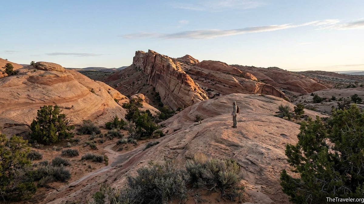
Understanding Comb Ridge and Why It Matters
Comb Ridge is a north-to-south monocline that stretches roughly 80 miles from near the Abajo Mountains in Utah to just past Kayenta, Arizona. Its tilted Wingate and Navajo sandstone layers form a rugged escarpment on the west and a maze of domes, canyons and alcoves on the east. Drivers on Utah State Route 95 catch one brief, spectacular crossing of the ridge, but the real rewards lie off the pavement where side roads and hiking routes reach canyons carved into the flanks of the formation.
The ridge sits within Bears Ears National Monument, a landscape that tribal nations consider living homeland, not just scenery. Archaeologists estimate there are thousands of cultural sites scattered across the drainages of Butler Wash, Comb Wash and adjacent mesas, including Ancestral Puebloan dwellings, storage granaries, kivas, rock art panels and field houses. Most sites are unmarked and unpublicized to protect them, but a small number, such as Butler Wash Ruins, have basic visitor facilities and signed access.
For modern travelers, Comb Ridge offers a rare combination of world-class archaeology, big desert vistas and genuine solitude. Yet that same remoteness means few services, variable road conditions and sometimes confusing land management boundaries. Planning ahead, carrying detailed maps and understanding how to behave around cultural resources are essential parts of any Comb Ridge itinerary.
Getting There, Seasons and Practical Logistics
Comb Ridge lies between the small towns of Blanding and Bluff in southeast Utah. Most visitors approach on Utah State Route 95, also known as the Bicentennial Highway, which crosses the ridge about 14 miles west of Blanding. From Salt Lake City, the drive is roughly 5.5 to 6 hours via US 6 and US 191 through Moab and Monticello. From Durango, Colorado, expect about 3 hours via US 160 and US 191. Rental cars are available in Moab, Cortez, and Durango; Bluff and Blanding are smaller and typically do not have national-brand agencies.
For first-time visitors interested in archaeological overlooks and moderate hiking, a standard passenger car is usually sufficient in dry weather. Butler Wash Ruins, one of the best-known sites on the east side of Comb Ridge, is reached by a paved pullout and signed trailhead on Highway 95 with a pit toilet and marked path. In contrast, exploring deeper into Butler Wash or driving the dirt road along Comb Wash on the west side often requires high clearance, and after storms these roads can become muddy or briefly impassable. Many local outfitters in Bluff and Blanding can provide current information on whether conditions are suitable for 2WD vehicles.
Spring and fall are the most comfortable seasons to visit. Daytime highs in April, May, late September and October are often in the 60s to 80s Fahrenheit, which is ideal for hiking exposed slickrock. Summer temperatures routinely climb above 90 or 100 degrees with almost no shade, turning mid-day hikes into hazardous endeavors. Winter can be cold with occasional snow or ice on shaded slickrock slopes; that can make some approaches, especially to alcove sites, surprisingly slippery. Whenever you visit, plan to carry far more water than you think you need, as there are no potable water sources at trailheads, and springs in side canyons are unreliable and should be treated if used.
Key Archaeological Stops You Can Visit Responsibly
One of the most accessible archaeological viewpoints in the Comb Ridge area is the Butler Wash Ruins overlook. The Bureau of Land Management maintains a signed pullout with a pit toilet and parking lot on Highway 95 near mile marker 111. From the lot, a well-marked trail of about 0.5 miles one way crosses open slickrock to an overlook opposite a large Ancestral Puebloan cliff dwelling. The round trip takes 30 to 45 minutes for most hikers. At the overlook, informational signs describe the site, which includes habitation rooms, storage structures and several kivas tucked under a sweeping alcove. Visitors are asked to stay on the developed viewpoint side and not descend into the canyon to the ruin itself, both for safety and to protect fragile masonry.
Farther south near Bluff, side roads along Butler Wash provide access to additional, mostly unsigned canyons where experienced hikers may encounter smaller dwellings, granaries and rock art high on the walls. The rock art panels along sections of Butler Wash and the central part of Comb Ridge include deer, bighorn sheep, human figures and more abstract symbols, some likely dating back many centuries. Because of increasing visitation, local organizations and the BLM have been cautious about widely publishing exact locations. Instead, it is common for visitors to stop at the Bears Ears Education Center in Bluff or a BLM office in Monticello to ask which canyons are recommended for day hikes and how best to minimize impact.
Comb Wash on the west side of the ridge provides access to another set of canyons, some with impressive alcove sites and granaries. A graded dirt road runs for roughly 18 miles between Highway 95 and US 163, paralleling the base of the ridge. In dry weather, high-clearance vehicles often travel this route to reach trailheads into canyons like Mule Canyon, which features well-known ruins such as the House on Fire site on nearby Cedar Mesa. Although Mule Canyon itself is technically on Cedar Mesa rather than the main ridgeline, many travelers combine these stops into a single trip, treating Comb Ridge as the scenic anchor of a wider archaeological loop.
Scenic Drives, Viewpoints and Landscape Photography
You do not have to be a hard-core hiker to appreciate Comb Ridge. The crossing on Highway 95 is a scenic highlight in its own right, especially in the late afternoon when warm light rakes across the tilted sandstone fins. Many road trippers driving the Trail of the Ancients Scenic Byway pause at informal pullouts on either side of the ridge to photograph the sweeping views across Comb Wash to the west and the domes and canyons of Butler Wash to the east.
For a more immersive scenic drive, experienced desert drivers with high-clearance vehicles often travel the Comb Wash road between Highway 95 and US 163 near the San Juan River. This 18-mile route runs beneath the western escarpment of the ridge, with the spine rising dramatically above cottonwood-lined washes. In dry conditions, the road surface is usually a mix of dirt, sand and embedded rock. After thunderstorms, however, low spots can accumulate deep mud or standing water. It is common for local guides or campground hosts in Bluff to advise visitors to check the forecast carefully and avoid the route for a day or two after major storms.
Photographers will find the ridge especially appealing during the “golden hours” shortly after sunrise and before sunset. From the east, morning light can be beautiful on the high spine, while evening light tends to illuminate the canyons and terraces on the west. Wide-angle lenses around 24 millimeters on a full-frame camera capture the scale of the monocline and the textured slickrock foreground. Tripods are useful, but many visitors are content with handheld shots from viewpoint pullouts and short walks from the car. Respect private land and signed closures, and avoid walking over fragile biological soil crusts just to line up a shot.
Outdoor Adventures: Hiking, Scrambling and Camping
Comb Ridge is essentially an open invitation to explore side canyons and slickrock domes, but the terrain can be more complex than it appears from the highway. Many of the best outings start from informal parking spots along Butler Wash and Comb Wash, where faint paths or game trails lead into narrow drainages. Day hikes might involve several miles of walking on slickrock benches, crossing sandy washes and occasionally scrambling up short, steep sections to reach alcoves or viewpoints.
For example, a typical moderate hike from a Butler Wash side road might involve following a sandy wash for 30 minutes, then using cairns to climb onto a slickrock bench that offers views of sculpted sandstone domes and the main comb of the ridge. Along the way you might pass under a small seep-fed hanging garden, where maidenhair ferns and monkeyflower cling to seeps that run intermittently through the spring and after storms. In many canyons, an informal social trail leads toward a cliff dwelling or rock art panel; in these cases, staying on the already-disturbed path helps concentrate impact.
Backcountry camping is possible on some public lands near Comb Ridge, especially in dispersed sites along Comb Wash and on nearby mesas, but regulations can be intricate. Certain parts of Cedar Mesa and nearby canyons require overnight permits and limit the number of groups to protect cultural resources. While some portions of the Comb Ridge area currently allow dispersed car camping in already-established clearings, rules evolve as visitation grows. Before planning to camp on pullouts or down dirt roads, visitors should check the latest guidance from the Bears Ears National Monument managers or local ranger stations, and always camp at least 200 feet from archaeological sites and water sources.
Those who prefer amenities will find small, privately operated campgrounds and simple motels in Bluff and Blanding. In high season, especially around spring break and autumn weekends, it is common for the few lodges in Bluff to fill up weeks in advance. Prices for basic motel rooms in these towns often fall somewhere in the modest range compared with larger tourist hubs like Moab, but they reflect the remoteness and limited supply of beds in the region.
Respecting Tribal Heritage and Protecting Fragile Sites
Comb Ridge lies within a landscape that is deeply significant to several Native American nations, including the Navajo Nation, Hopi Tribe, Ute Mountain Ute Tribe, Ute Indian Tribe and the Pueblo of Zuni. Many of the canyons, springs and rock formations visitors admire are tied to origin stories, ceremonial histories and ongoing cultural practices. Modern visitation exists alongside this living connection, so thoughtful behavior from travelers is not just courteous; it is a central part of responsible tourism.
When visiting cliff dwellings and rock art, perhaps the most important rule is to look, not touch. The oils on human skin can permanently darken petroglyphs and pictographs. Even brushing against the edges of thousand-year-old masonry can loosen stones or mortar. Travelers should stay on established paths, avoid entering rooms or kivas, and never sit or lean on walls. If you find pottery sherds or other artifacts on the ground, admire them, photograph them, but leave them exactly where they are.
Another often-overlooked courtesy is to keep noise levels low near cultural sites. Many of these alcoves and canyons offer natural amplification; loud conversations or music can carry surprising distances. For tribes that still visit these areas for traditional purposes, encountering noisy crowds at ancestral homes can be jarring. Small groups, soft voices and a willingness to step aside if others are quietly reflecting all help maintain a respectful atmosphere.
Finally, responsible visitation includes recognizing that most site locations are intentionally not signed or promoted. Posting exact GPS coordinates of sensitive sites on social media can quickly overwhelm them, leading to trampling, graffiti or looting. Many experienced desert travelers now share photos of rock art or ruins without geotags, describe routes in general terms and encourage others to learn from local education centers about which places are appropriate to visit.
Safety, Permits and Staying Within the Rules
Although Comb Ridge is not as famously rugged as nearby canyon systems like Grand Gulch, it still poses real risks to the unprepared. Temperatures can swing dramatically between day and night. In summer, hikers frequently underestimate how quickly water needs rise in dry air, leading to heat exhaustion or heat stroke. A realistic starting point is to carry at least 3 liters of water per person for a half-day hike and more if you plan to be out longer, along with salty snacks, sun-protective clothing and a wide-brim hat.
Navigation can also be surprisingly challenging. Many routes are unofficial and follow cairns across open rock rather than distinct dirt paths. A printed topographic map, an offline-capable navigation app and a basic understanding of how to orient yourself using landmarks are all helpful. Cell service is spotty to nonexistent in most canyons. Local search and rescue teams respond to calls from visitors who miss turnoffs on slickrock benches or underestimate how long it will take to return to the vehicle, especially in the evening when light fades and temperatures drop.
Regulations in the broader Bears Ears region are complex and evolving. Day hiking to sites like Butler Wash Ruins generally does not require a permit at present, while many overnight trips on Cedar Mesa and in certain canyons do. Wood fires may be restricted or prohibited at times due to wildfire risk. Dogs may be required to stay on leash or may be discouraged entirely near sensitive archaeological areas to prevent digging or disturbance. Before a trip, travelers should plan to stop at a local ranger station or visitor information center to ask what rules apply at the specific canyon or wash they plan to visit that day.
Driving regulations deserve attention as well. Side roads posted as closed to motorized travel should be strictly avoided, even if tire tracks suggest others have recently ignored the closure. Cutting across open desert to create informal campsites or bypass muddy sections of road damages cryptobiotic soil and vegetation that may take decades to recover. Sticking to existing routes and pullouts, respecting gate closures and turning around when conditions deteriorate are all part of traveling responsibly in this fragile landscape.
The Takeaway
Comb Ridge rewards those who come prepared: prepared to hike under an intense desert sun, to navigate unmarked slickrock benches, and to engage with the cultural depth of the place with humility and care. In return, visitors gain access to a ridge line that defines the horizon for miles, alcoves that have sheltered people for a thousand years and quiet canyons where the sound of wind over cottonwood leaves can feel like the loudest noise for hours.
Whether your priority is photographing sandstone fins at sunset, peering across a canyon at a well-preserved cliff dwelling or tracing the faint lines of ancient petroglyphs from a respectful distance, Comb Ridge offers a spectrum of experiences shaped by how much effort and thought you invest. Pair short, accessible stops like the Butler Wash Ruins overlook with a more adventurous side-canyon hike, and allow time to learn from local tribal-led or BLM education centers.
As visitation grows, the future of Comb Ridge will depend on how today’s travelers behave. By staying on durable surfaces, leaving artifacts in place, minimizing noise and choosing when and where to share your experiences publicly, you help ensure that the ridge’s archaeological sites and desert ecosystems remain intact for the next generation of explorers and for the descendant communities whose stories are written across these canyon walls.
FAQ
Q1. Where is Comb Ridge and what towns make the best base?
Blanding and Bluff in southeast Utah are the primary base towns for visiting Comb Ridge. The ridge lies between them, with easy access from Utah State Route 95 and additional approaches from US 163 near the San Juan River.
Q2. Do I need a four-wheel-drive vehicle to visit Comb Ridge?
No for basic sightseeing; a standard passenger car is usually sufficient in dry weather for paved access points such as the Butler Wash Ruins overlook. High-clearance or four-wheel drive is strongly recommended if you plan to drive the dirt roads along Comb Wash or deeper side roads in Butler Wash, especially after rain.
Q3. Are permits required to hike to sites along Comb Ridge?
Day hikes to a few developed overlooks typically do not require permits, but overnight trips and certain nearby canyons on Cedar Mesa do. Because rules change as visitation increases, travelers should confirm current permit requirements with local land managers before setting out.
Q4. When is the best time of year to visit Comb Ridge?
Spring and fall are generally the best times, with more moderate temperatures that make hiking and exploring safer and more pleasant. Summer heat can be extreme, and winter visits may involve cold conditions and occasional snow or ice on shaded slickrock.
Q5. Can I camp near Comb Ridge?
Some dispersed camping is allowed on public lands near Comb Ridge in already-established sites, and there are small campgrounds and motels in Bluff and Blanding. Because regulations vary by location and are updated as conditions change, check current guidance for camping and fire restrictions before your trip.
Q6. How should I behave around archaeological sites?
Look but do not touch, and never enter rooms, sit on walls or handle artifacts. Stay on existing paths, keep noise low, avoid posting exact locations of sensitive sites online and pack out all trash. These simple practices help preserve fragile cultural resources.
Q7. Is Comb Ridge suitable for families with children?
Yes, with caution and route selection. Short walks like the Butler Wash Ruins overlook can work well for families, but parents should closely supervise children near cliff edges, keep them off ancient walls and ensure everyone stays hydrated and protected from the sun.
Q8. Will I have cell service in the Comb Ridge area?
Coverage is intermittent to nonexistent in most canyons and along many dirt roads. Visitors should not rely on mobile phones for navigation or emergency contact and are wise to let someone know their plans and expected return time before heading out.
Q9. Are guided tours available for Comb Ridge?
Yes. Several small outfitters based in Bluff, Blanding and nearby communities offer guided day hikes and cultural tours in the broader Bears Ears region, including canyons around Comb Ridge. Guides can help interpret archaeology, manage navigation and ensure that visits follow local regulations and best practices.
Q10. What gear is essential for a day hike at Comb Ridge?
At a minimum, bring sturdy footwear with good traction, ample water, sun protection, a map or GPS with offline maps, snacks, basic first-aid supplies and layers for changing temperatures. Many visitors also carry trekking poles for stability on slickrock and a small flashlight or headlamp in case hikes take longer than expected.