
Hawksbill Mountain is the highest peak in Shenandoah National Park, topping out at just over 4,050 feet and delivering some of the best views in Virginia’s Blue Ridge. Because it is both accessible and spectacular, it is one of the park’s most popular half-day hikes. This guide brings together everything you need to know to plan a smooth visit, from choosing the right trail and navigating parking to timing your hike for the best light at the summit overlooks.
Get the latest updates straight to your inbox!
Where Hawksbill Mountain Is and Why It Matters
Hawksbill Mountain rises along Skyline Drive in the Central District of Shenandoah National Park, straddling the border of Madison and Page counties in Virginia. The summit is the highest point in the entire park, as well as the high point for both counties, which is part of what makes it such a draw for hikers working through state or national high point lists. On a clear day, the summit platform offers sweeping views across the Shenandoah Valley to the Allegheny Mountains, and east toward the rolling Virginia Piedmont.
Practically, this means Hawksbill is easy to combine with other classic Skyline Drive stops. It sits roughly between the Thornton Gap entrance station to the north and the Swift Run Gap entrance to the south. Many travelers pair a hike here with a picnic at Big Meadows or additional short hikes like Dark Hollow Falls and Stony Man on the same day, taking advantage of the park’s scenic overlooks and facilities concentrated in this central section.
Because Skyline Drive is a mountain road that can close for ice and snow, access to Hawksbill is seasonal in practice even though the summit trails are technically open year-round. In winter, especially from December through March, you may find gates closed at lower elevations after storms, turning what is normally a quick 1 to 2 hour outing into a much longer walk on the drive itself. In late spring, summer and fall, when the road is generally fully open, the main planning challenges are crowding at trailheads and rapidly changing mountain weather.
For many visitors, especially first-timers to Shenandoah, Hawksbill is a perfect introduction to Blue Ridge hiking: short mileage, quickly gained elevation, and a stone observation deck at the top that makes lingering with a camera or picnic feel easy and safe. Understanding the trail and parking options will help you avoid some of the congestion that comes with that popularity.
Choosing the Right Trail: Upper, Lower & Loop Options
There are three main ways most hikers tackle Hawksbill: the Upper Hawksbill Trail, the Lower Hawksbill Trail, and a longer loop that links several paths including the Appalachian Trail. All end at or near the same summit area but differ in distance, steepness and feel, which makes it relatively simple to match a route to your fitness and schedule.
The Upper Hawksbill Trail begins from the Upper Hawksbill parking area around mile 46.7 on Skyline Drive. The National Park Service and multiple hiking resources describe this as an out-and-back hike of roughly 2 to 2.2 miles round trip with about 520 feet of elevation gain. The grade is steady rather than punishing, following an old fire road through mixed hardwood forest to the Byrds Nest 2 shelter and then on to the stone observation platform. For families with school-age kids or travelers who are fit but not avid hikers, this is generally considered the most forgiving option.
The Lower Hawksbill Trail starts from Hawksbill Gap parking at about mile 45.5. This is the most direct and steepest route to the top. The park service lists it at about 1.7 miles round trip with around 690 feet of elevation gain. The trail climbs briskly through the woods and reaches the summit area faster than Upper Hawksbill, but the grade can feel taxing for beginners, particularly on humid summer days. It is a strong choice for hikers who like a short, efficient workout with a big payoff and are comfortable with sustained uphill walking.
For those looking for a bit of variety, the Hawksbill loop options combine parts of the Lower Hawksbill Trail, the Salamander Trail and the Appalachian Trail into a roughly 2.7 to 3 mile circuit. One common version starts at Hawksbill Gap, ascends via Lower Hawksbill or Salamander, follows the ridge-top to the summit and observation deck, then returns on a different leg. This style of hike takes a little more navigation and time but rewards you with changing scenery, including boulder fields and additional viewpoints along the AT, and avoids retracing your exact steps.
Trailhead Access, Parking & Practical Logistics
Hawksbill’s popularity means that parking and timing matter almost as much as which trail you choose. Both primary trailheads sit directly on Skyline Drive, the park’s main north-south scenic road. Access requires paying the Shenandoah National Park entrance fee at one of the entrance stations or using a valid federal interagency pass. As of mid-2026, a private vehicle entry typically costs in the region of 30 to 35 US dollars for a pass valid several days, while the annual Shenandoah-specific pass and America the Beautiful passes are options for frequent visitors or those continuing on to other national parks.
The Upper Hawksbill parking lot near mile 46.7 is relatively small, with space for roughly 15 to 20 vehicles, and it fills quickly on peak fall foliage weekends and fair-weather summer Saturdays. The Hawksbill Gap parking area at around mile 45.5 has a bit more turnover because it serves multiple trail options, but it too can reach capacity by mid-morning. On a busy October Saturday, it is common to see cars circling or waiting for departing hikers to free up spots. Arriving before 9 am or targeting late afternoon after 3 pm greatly increases your chances of an easy parking experience.
There is no overflow lot in the immediate area, and roadside parking is constrained by guardrails and drop-offs, so it is wise not to count on simply pulling onto the shoulder. Rangers periodically enforce no-parking zones to keep Skyline Drive passable for emergency vehicles. If both trailhead lots are full, an alternative is to continue a few miles to Big Meadows, park there, and enjoy a different hike or scenic overlook, then try Hawksbill later in the day as traffic thins.
Facilities at the trailheads themselves are minimal. You will not find water taps at Upper Hawksbill or Lower Hawksbill. Restrooms are not located directly at the parking lots but can be found at nearby developed areas such as Big Meadows Wayside and the Byrd Visitor Center, roughly a 10 to 15 minute drive away. This means practical steps like filling water bottles, using restrooms and checking weather radar are best handled before you turn into the small Hawksbill parking entrances, not after you arrive and find a hard-won space.
On the Trail: What to Expect Underfoot and Overhead
Most of Hawksbill’s standard routes are well-defined and maintained, appropriate for regular hiking shoes or lightweight boots rather than full mountaineering gear. On the Upper Hawksbill Trail, expect a wide path with compacted dirt and scattered rocks, shaded by oaks and other hardwoods. The elevation gain is spread over the distance, so you will feel a gradual uphill rather than sharp, calf-burning pitches. In wet weather, the dirt can become slick, but roots and embedded stones give decent traction if you watch your foot placement.
The Lower Hawksbill Trail is narrower and steeper in places, with some short, rocky segments that demand more attention on the descent. It is still well within the comfort zone of most fit day hikers, including older kids, but trekking poles can help with balance and knee strain on the way down. Many people report taking around 35 to 45 minutes to climb from Hawksbill Gap to the summit via this route, with a similar or slightly shorter time to return, assuming brief photo stops along the way.
Weather changes quickly at Hawksbill’s elevation, even in summer. A July afternoon can start warm and humid at the trailhead and turn breezy and markedly cooler at the top. In late October and November, hikers sometimes step from sunshine into cloud as they climb through a layer of fog, finding the summit deck socked in one minute and suddenly clear the next. Light insulating layers and a wind-resistant jacket, even in warmer seasons, make it much more comfortable to linger at the viewpoints.
For safety, standard Blue Ridge precautions apply. Black bears live throughout Shenandoah, though encounters on Hawksbill’s well-used trails are relatively uncommon and typically brief. Keep any snacks sealed, give wildlife plenty of space, and follow posted guidelines about food storage and observation distances. Cell service on the mountain can be patchy, especially with some carriers, so do not plan on relying on a live map or messaging. Download an offline map in advance and let someone know your general plans and return time, even if you only expect a short, straightforward hike.
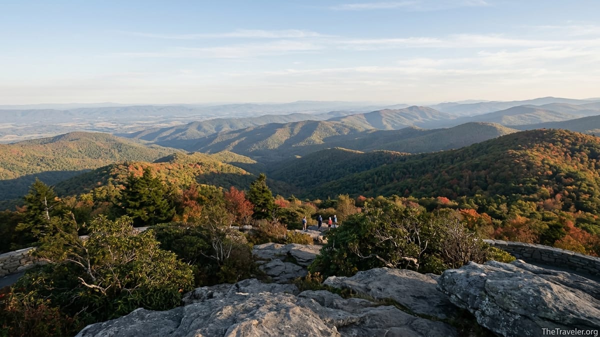
Summit Experience, Scenic Overlooks & Photography Tips
At the top of Hawksbill you will find a mix of built and natural viewpoints. The most obvious feature is the stone observation platform perched near the crest, which offers near 360-degree views. On a clear day, you can pick out the patchwork of farms in the Shenandoah Valley to the west, the sinuous line of Massanutten Mountain, and layers of blue ridges fading south toward peaks like Old Rag and Bearfence. To the east, the landscape softens into rolling foothills that eventually give way to the Virginia Piedmont.
Just below the platform stands the Byrds Nest 2 shelter, a stone hut with picnic tables that provides some wind protection and a convenient place to regroup or snack before or after stepping out to the open rock. Around the summit, social paths lead onto rock outcrops. Visitors are encouraged to stay on hardened surfaces and marked overlooks both for safety and to protect fragile plants that grow in the thin summit soil. The National Park Service has in recent years limited access to some outcrops to reduce erosion, so expect to see signs directing traffic and respect any small closure areas you encounter.
For photographers, timing is everything. Sunrise from Hawksbill can be ethereal, with low fog pooling in the valley below while the first light touches the ridges. This requires a pre-dawn start in the dark, so a headlamp, warm layers and familiarity with the route are essential. Many casual visitors instead aim for golden-hour evening light, starting the hike 60 to 90 minutes before sunset so they can reach the top, enjoy the soft side-light on the surrounding peaks, and then descend before it is fully dark. Midday visits provide the widest window of time but also the harshest lighting and greatest crowds.
Tripods are welcome but can be awkward on narrow platform edges during peak times. A practical compromise is to bring a compact travel tripod or rely on high-ISO handheld shooting. Because the views span such a wide arc, a standard zoom lens equivalent around 24–70 mm works well. Even smartphone cameras capture excellent panoramas from the platform. Remember that the summit can be windy: secure hats, strap cameras firmly and avoid stepping too close to exposed edges where sudden gusts can throw off your balance.
Seasons, Crowds & Suggested Itineraries
Hawksbill is technically a year-round destination, but the feel of the hike changes dramatically with the seasons. Spring, typically April through early June, brings wildflowers and fresh green leaves along the trails, along with variable temperatures and occasional lingering snow or ice in shaded spots. Summer delivers lush foliage and more stable access but also hazier vistas and afternoon thunderstorms that can roll through quickly. Fall, especially from late September into late October, is the busiest period, as leaf-peepers flock to Skyline Drive and every overlook and trailhead, Hawksbill included, sees surging visitation.
In practical terms, travelers visiting on peak fall weekends should expect full parking lots by late morning and congestion on the summit platform. A workable strategy is to turn Hawksbill into an early or late anchor to the day. For example, you might enter the park at Thornton Gap just after sunrise, drive the 30 to 40 minutes south to Hawksbill Gap, complete the Lower Hawksbill out-and-back while crowds are still light, then continue south to Big Meadows for lunch and a leisurely afternoon. Alternatively, you can spend the midday hours at less trafficked overlooks or on a picnic, then tackle the Upper Hawksbill route for late-afternoon light when some of the day trippers have started to depart.
Winter outings are quieter and reward those comfortable with cold-weather hiking. If Skyline Drive is open to the trailheads, you can often have long stretches of the Upper or Lower Hawksbill trails nearly to yourself, with frost or snow dusting the rocks at the summit. However, conditions can change overnight. The park’s official channels often announce temporary closures of segments of Skyline Drive after storms, so checking the latest status on the morning of your hike avoids long detours. Microspikes or traction devices are useful if packed snow lingers on the steep sections of the Lower Hawksbill route.
For first-time visitors with a full day in the park, a classic itinerary might combine Hawksbill with a waterfall hike such as Dark Hollow Falls and a stop at Big Meadows Wayside for a casual meal. Those staying overnight at the Big Meadows Lodge or campground can treat Hawksbill as a flexible sunrise or sunset hike, adjusting based on weather. Families with younger children or mixed fitness levels often find the Upper Hawksbill trail’s moderate grade and longer distance more pleasant than forcing a fast push up the steeper Lower Hawksbill, especially in summer heat.
Responsible Hiking, Safety & What to Bring
Although Hawksbill is not a long or technical hike by mountain standards, minor preparation and respect for the environment go a long way toward keeping the experience enjoyable for everyone. At a minimum, each hiker should carry water, a small snack, and a basic layer for warmth. For planning purposes, many visitors bring about one liter of water per person for the Upper Hawksbill route and at least that much for the steeper Lower Hawksbill, adjusting for season and personal needs. Light trail shoes or hiking boots with good tread, along with sun protection and a hat, are appropriate most of the year.
Shenandoah National Park encourages Leave No Trace principles throughout its trail network. On Hawksbill, this translates into staying on established paths, packing out all trash (including fruit peels and tissue), avoiding loud music at the summit, and yielding politely on narrower trail sections. Dogs are allowed on both main routes but must remain leashed on a six-foot or shorter leash. In practice, this makes it easier to manage encounters with other hikers, especially children, and with local wildlife.
Storms can develop rapidly over the Blue Ridge, especially on humid summer afternoons. If you hear thunder or see dark clouds stacking up to the west, consider turning back early rather than pushing on to the exposed summit. Lightning is a serious hazard on open rock and at observation decks. Carrying a light rain jacket or poncho, even when the forecast looks fair, can turn an unexpected passing shower from a miserable experience into a minor inconvenience.
Finally, give yourself more time than the raw mileage might suggest. While fit hikers often complete the Lower Hawksbill out-and-back in about an hour and the Upper Hawksbill in around 90 minutes, most visitors happily stretch those numbers with photo stops, rest breaks and summit lingering. Building an extra half hour or more into your schedule reduces the temptation to rush, which in turn lowers the risk of slips and rolled ankles on the descent, particularly near the end of a long day exploring Skyline Drive.
FAQ
Q1. How long does it take to hike Hawksbill Mountain?
Most visitors spend about 1 to 1.5 hours on the Lower Hawksbill out-and-back and 1.5 to 2 hours on the Upper Hawksbill route, including time at the summit.
Q2. Which trail to Hawksbill summit is easiest?
The Upper Hawksbill Trail from the parking area near mile 46.7 on Skyline Drive is generally considered the easiest, with a moderate grade spread over roughly 2 miles round trip.
Q3. Is Hawksbill Mountain suitable for beginners or kids?
Yes, many beginners and families hike Hawksbill every year. The Upper Hawksbill route is often best for active kids and newer hikers, while the steeper Lower Hawksbill suits those comfortable with sustained uphill walking.
Q4. Do I need special permits to hike Hawksbill?
No special hiking permit is required, but you do need to pay the standard Shenandoah National Park entrance fee or hold a valid federal pass to drive Skyline Drive to the trailheads.
Q5. When is the best time of day to visit Hawksbill for views?
Early morning and late afternoon typically offer the best light and fewer crowds. Sunrise and sunset can be spectacular but require hiking in low light with proper headlamps and warm layers.
Q6. Is there parking at the Hawksbill trailheads?
Yes, there are small lots at both the Upper Hawksbill and Hawksbill Gap trailheads, but they often fill on busy weekends. Arriving early or later in the afternoon improves your chances of finding a space.
Q7. Are dogs allowed on Hawksbill Mountain trails?
Dogs are allowed on both main Hawksbill routes as long as they are kept on a leash no longer than six feet and owners pack out pet waste.
Q8. What should I bring for a Hawksbill hike?
Comfortable hiking shoes, about a liter of water per person, a light snack, weather-appropriate layers, sun protection and a small first-aid kit are usually sufficient for most visitors.
Q9. Can I hike Hawksbill Mountain in winter?
Yes, you can hike Hawksbill in winter when Skyline Drive is open, but you should be prepared for cold, wind, possible ice or snow on the trail, and sudden weather changes.
Q10. Is Hawksbill Mountain a good place for photography?
Absolutely. The stone observation platform and nearby rock outcrops offer far-reaching views that work well for everything from smartphone panoramas to more advanced landscape photography setups.