


Dettifoss is one of Iceland’s most powerful and dramatic waterfalls, thundering over the edge of the Jökulsá á Fjöllum glacial river in Northeast Iceland. Set within the Jökulsárgljúfur section of Vatnajökull National Park, it sits in a wild canyon landscape alongside its near neighbours Selfoss upstream and Hafragilsfoss downstream. For many travelers driving the Ring Road or exploring the Diamond Circle route, Dettifoss is the raw, untamed counterpart to more easily reached waterfalls elsewhere in the country, and a highlight worth planning carefully around.
Get the latest updates straight to your inbox!
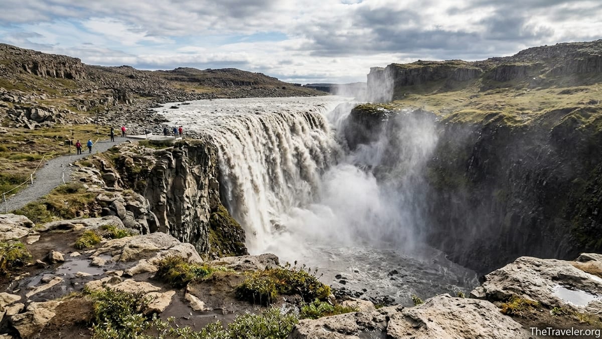
What and where is Dettifoss?
Dettifoss lies in North Iceland, roughly between Lake Mývatn and Ásbyrgi canyon, in the deep gorge carved by the Jökulsá á Fjöllum river. This river drains the northern part of Vatnajökull, Europe’s largest ice cap, and brings a heavy load of glacial silt that gives the water its characteristic grey-brown colour. The waterfall itself is about 100 meters wide and drops around 44 meters into a narrow canyon, with a continuous roar and spray that can often be felt before the falls are even in sight.
The falls sit inside the Jökulsárgljúfur area of Vatnajökull National Park, a protected landscape of steep canyon walls, rock formations and smaller side gorges. Dettifoss is not an isolated attraction but one feature in this wider system, which also includes marked hiking routes, smaller viewpoints and picnic areas. Understanding this context helps visitors appreciate that a stop here can be either a quick photo break or part of a much longer day exploring the canyon.
Just upstream from Dettifoss lies Selfoss, a lower but very wide horseshoe-shaped waterfall reached by a short walk along the same clifftop path. Downstream is Hafragilsfoss, framed by some of the most impressive canyon scenery in the region and accessed from separate parking areas on both sides of the river. Many travelers visit all three in a single outing, using Dettifoss as the main anchor. Together they offer different perspectives on the same river system and show how glacial floods have shaped the landscape over thousands of years.
In Iceland and across Europe, Dettifoss is frequently described as one of the continent’s most powerful waterfalls in terms of water volume and force. Exact rankings vary between studies and seasons, so it is safest to think of it as a major waterfall rather than fixate on superlatives. The experience on the ground matches that reputation: even in lower flow conditions the combination of canyon, noise and spray feels notably more intense than at many other Icelandic falls.
Why Dettifoss is special without the hype
Dettifoss stands out less for height or elegance and more for a sense of raw energy. The glacial water charges over a rough lip of basalt and plummets into a confined gorge, generating mist that often rises high above the canyon. On still days, rainbows can form in the spray when sunlight hits at the right angle. On windier days, that same spray can drift across viewpoints and leave clothes and camera gear damp within minutes.
The surrounding Jökulsárgljúfur canyon adds to the impact. Unlike some Icelandic waterfalls that sit close to farms or roads, Dettifoss feels set apart in a semi-desert of gravel plains and low vegetation. Approaching along the clifftop paths, visitors look down into a steep, rugged gorge with little manmade development in sight. This makes it easy to combine waterfall viewing with short or longer walks along the canyon rim and to nearby viewpoints.
The falls also sit near the midpoint of the Diamond Circle, a promoted touring loop in North Iceland that links Goðafoss, Lake Mývatn, Dettifoss, Ásbyrgi canyon and the harbour town of Húsavík. For travelers already heading through North Iceland, Dettifoss is the wildest-feeling stop on that circuit and a natural way to add contrast to the geothermal and coastal experiences elsewhere on the route. It is not necessarily a reason on its own to fly north from Reykjavík, but as part of a broader North Iceland or Ring Road trip it is a compelling highlight.
Compared with other well-known waterfalls like Skógafoss or Seljalandsfoss in South Iceland, Dettifoss is more remote, less developed and typically a little less crowded, especially outside peak summer. Those differences are part of its appeal, but they also mean visitors must pay more attention to road conditions, walking surfaces and basic safety near canyon edges. For travelers who value wild scenery and do not mind a bit of exposure to the elements, the extra planning is usually rewarded.
How Dettifoss fits into North Iceland and Ring Road itineraries
Most visitors reach Dettifoss either as a detour from the Ring Road during a full circuit of Iceland, or as one element in a focused North Iceland trip using Akureyri or the Mývatn area as a base. North Iceland tourism and car-rental guides published in 2025 and 2026 generally describe the Diamond Circle driving loop from Akureyri as about 250 to 300 kilometers, with at least 3 to 5 hours of pure driving, depending on the exact variant. That does not include time for stops, photos, food or hikes, so practical itineraries usually devote a full day or, preferably, two days to the route.
From the Mývatn area, including the small village of Reykjahlíð, the turnoff to Dettifoss on the paved Route 862 is around 45 to 60 minutes’ drive in normal summer conditions, depending on the specific accommodation. Visitor maps from North Iceland tourism offices typically indicate about 1.5 hours from Akureyri to Dettifoss and roughly 1 hour from Húsavík, under good weather and road conditions and without heavy traffic. Travelers planning trips for future seasons should verify these drive time estimates using current mapping tools and official Icelandic road distance tables for their specific route at the time of travel.
Dettifoss can also be reached from Egilsstaðir in East Iceland as part of a Ring Road leg. Driving guides aimed at Ring Road travelers often suggest around 2.5 to 3 hours from Egilsstaðir to the Mývatn area, with the additional detour to Dettifoss via Route 862 adding at least one more hour of driving plus time on foot at the falls. This makes Dettifoss a realistic but relatively long same-day addition when traveling between East and North Iceland, especially in summer when daylight is abundant.
On-site, visitors who want to see Dettifoss only from one main viewpoint on the west side can technically do so in about an hour, including the short walk from the parking area. However, many travelers underestimate how much time they will want to spend watching the falls, taking photographs, and walking to Selfoss or down the canyon edge for alternative angles. As a planning guideline, allowing at least two hours at Dettifoss and Selfoss together is realistic, and three hours feels comfortable if you like to move at a slower pace or continue to Hafragilsfoss by car.
Access and orientation: west side vs east side
Dettifoss can be viewed from both banks of the Jökulsá á Fjöllum river. The west side, reached via Route 862, is the main access point today. Regional tourism information and recent driving guides note that this side now has a paved approach road from the south, a larger formal parking area, marked paths, viewing platforms and toilet facilities in season. For most first-time visitors, this is the most straightforward and commonly recommended side because of its infrastructure and typically easier driving conditions.
The east side is reached by gravel Route 864 and offers a more side-on perspective of the falls, with different compositions for photography and another sense of the canyon’s scale. However, Route 864 is generally rougher, can be potholed, and has more limited seasonal accessibility. Road information services in Iceland regularly report that Route 864 is often closed by snow or thaw damage for significant parts of winter and spring. Travelers should treat access here as genuinely conditional and should not assume it will be open at the same time as Route 862.
In all seasons, visitors should check the latest road conditions and seasonal opening status for Routes 862 and 864 on the official Icelandic Road and Coastal Administration channels and any park-specific updates. For an article intended to be current at publication, the writer should verify typical opening and closing patterns and record a check date, for example “Road access and seasonal passability last checked with Icelandic road authorities in May 2026.” That information should be revisited periodically, since road improvements, maintenance and climate patterns can alter the details over time.
At the falls themselves, viewing is from clifftop paths and platforms rather than boardwalks directly at the brink. On the west side, constructed viewpoints sit close to the canyon edge but are set back from the true lip of the waterfall, with roped or fenced sections and clear gravel or stone paths in between. On the east side, paths are more informal with a mix of marked routes and rocky ground. Any article should confirm the exact layout of current viewing platforms, recent path closures or rerouting with up-to-date park information at the time of writing, and again before the intended season of reader travel.
How to visit: self drive, tours and different travel styles
For independent travelers with a rental car, Dettifoss is typically visited as part of a self-drive Ring Road itinerary or as a segment of a dedicated Diamond Circle loop. From the south, most drivers leave the Ring Road at the signed junction for Route 862 north toward Dettifoss, follow the paved road across barren highland terrain and reach the main west-side parking area after roughly 25 to 30 kilometers. From the north, those who have visited Ásbyrgi or Húsavík often follow Route 85 and then Route 862 southwards along the canyon rim, reaching a smaller north approach to the same waterfall region. Parking areas are clearly signed, but travelers should follow current roadside signs and any closures rather than relying solely on older guidebooks.
Day tours are widely offered from Akureyri and from the Mývatn area in summer, usually bundled with Lake Mývatn geothermal stops or Ásbyrgi as part of a Diamond Circle style itinerary. These tours typically involve several hours of bus or minibus driving and 60 to 90 minutes on foot around Dettifoss and Selfoss, depending on conditions and group pace. For travelers who prefer not to drive, such tours remove the stress of watching road and weather forecasts and usually include commentary on geology and local history. When assessing options, pay attention to whether the tour visits the west side, east side or both, and whether winter departures use specialized vehicles.
In winter and early spring, several operators run super jeep or modified 4x4 tours to Dettifoss from Akureyri or Mývatn when conditions allow. These trips rely on vehicles equipped for deep snow and rough surfaces and often adjust the exact route based on daily weather and avalanche guidance. Because winter access can change quickly, a responsible article should instruct readers to confirm operating seasons, minimum group sizes and contingency plans directly with current operators before booking, especially for travel between November and April.
Some visitors treat Dettifoss as a quick photo stop, walking directly from the west-side parking area to the main viewpoint, taking photographs and returning to their vehicle within an hour. Others prefer a slower pace, looping to Selfoss on foot and then driving to Hafragilsfoss for a broader canyon panorama. The short walks from the main west-side parking to the viewpoints for Dettifoss and to Selfoss are usually counted in hundreds of meters rather than kilometers in official park descriptions, but the exact waymarking and distances should be checked against the latest Vatnajökull National Park material and noted with a verification date.
Seasonality, weather and safety considerations
North Iceland experiences significant seasonal contrasts that strongly affect Dettifoss access and the on-site experience. In high summer, long daylight hours allow flexible timing, and both Routes 1 and 862 are usually clear of snow and ice. Even then, the spray from Dettifoss can make nearby rocks damp and slippery, and strong winds can carry mist across paths. In the shoulder seasons of late spring and early autumn, there may be a mix of bare ground, lingering snow patches and icy sections on both roads and trails.
In winter, snow, ice and limited daylight are defining factors. National road information services frequently report full or partial closures of Route 864 for extended winter periods, and temporary closures or difficult conditions on parts of Route 862. Ice ridges, blown snow and reduced visibility are common. Any planning guide should clearly state that access to Dettifoss in winter is not guaranteed, especially for standard rental cars, and that visitors must check live road condition updates on the morning of travel, monitor weather forecasts and be prepared to change plans if conditions deteriorate.
On-site safety deserves particular attention, because much of the viewing is near steep canyon edges. Park guidance typically urges visitors to stay on marked paths, avoid stepping over ropes or barriers, and keep a firm hold of children in exposed sections. Rocks can be wet, uneven and in places undercut by erosion that is not immediately visible from above. Good footwear with strong grip is advisable year-round, and in winter or icy shoulder-season conditions, traction aids such as microspikes can be valuable. An updated article should check for any current safety advisories or official campaign messages from Vatnajökull National Park or the national environment agency and summarize these with a clearly stated check date.
Weather patterns in North Iceland are variable and can change quickly. Summers are often cool with a mix of sun, cloud and showers, and strong winds are possible at any time of year. Autumn and spring bring more frequent frontal systems, with low cloud and rain or sleet that can reduce visibility in the canyon. Winter cold spells can be interrupted by milder, stormy periods that create heavy wet snow and difficult driving conditions. Rather than relying on assumed temperatures, travelers should check forecasts from the Icelandic meteorological service in the days before their visit and be ready for conditions that feel several degrees colder near the spray and in exposed winds than in nearby towns.
What to combine with Dettifoss on the Diamond Circle
Dettifoss slots naturally into a larger exploration of North Iceland. Immediately nearby, most visitors add Selfoss and Hafragilsfoss, either on foot from the Dettifoss parking area or by short additional drives to dedicated viewpoints. Together, these three waterfalls provide a varied sequence of perspectives on the Jökulsá á Fjöllum canyon and can comfortably fill half a day if you enjoy photography and short walks.
Continuing north on Route 862 brings travelers toward Ásbyrgi, a distinctive horseshoe-shaped canyon with forested walking paths and a calm pond at its base. From there, the Diamond Circle can be followed west toward the coastal town of Húsavík, known for whale watching and sea baths, and then back toward Akureyri along Route 85 and the Ring Road. In the other direction, south of Dettifoss, the route swings back toward Lake Mývatn, an area of geothermal fields, pseudocraters, lava formations and bathing pools that can easily justify an overnight stop on its own.
For those driving the full Ring Road, Dettifoss is often paired with Mývatn and Goðafoss in a single North Iceland day, especially in summer when daylight hours are long. A common pattern, described in multiple North Iceland road trip guides, is to travel from Egilsstaðir to Mývatn with a detour to Dettifoss, then stay overnight near the lake and continue the next day to Goðafoss and Akureyri, possibly adding Húsavík as a side trip. This splits driving more evenly and leaves enough time to appreciate each major stop instead of rushing between them.
Travelers with two days for the Diamond Circle can slow the pace further. One day might focus on Goðafoss, Mývatn and nearby geothermal sites, with an evening soak in a local nature bath. The second day can then focus on Dettifoss, Selfoss, Hafragilsfoss and Ásbyrgi before looping to Húsavík for a harbor walk or late whale watching tour and returning to Akureyri or another base. The exact order depends on accommodation and forecast wind direction, which can influence whether spray at Dettifoss blows toward or away from the viewing points.
On-the-ground practicalities and current information to verify
Facilities at Dettifoss are modest but important to understand before you arrive. The west-side parking area accessed via Route 862 has marked parking bays for cars and larger vehicles, information boards, and toilet facilities in the main visitor season. Official park and tourism sources in recent years have generally described these toilets as seasonal, opening roughly in late spring and closing again in autumn, with no permanent visitor center or café on-site. The east side has significantly fewer facilities, typically just a smaller parking area and basic information signs when the road is open.
Parking and access policies for national park sites in Iceland evolve over time, and any accurate travel guide must confirm the current status of parking fees or entrance charges before publication. As of recent seasons, many Jökulsárgljúfur sites have remained free to visit, but some national park areas elsewhere in Iceland have introduced paid parking. Writers should therefore check the latest Vatnajökull National Park and Visit North Iceland information for Dettifoss specifically and state a verification date, for example “Parking and toilet use at the Dettifoss west-side lot remained free of charge as of June 2026.” If fees are introduced, these should be described in approximate terms, acknowledging that amounts may change.
Accessibility for visitors with reduced mobility is limited. The approach paths from the west-side parking area to the main viewpoints are relatively short but include uneven stone steps, gravel surfaces, small inclines and sections exposed to wind and spray. There are no enclosed viewing shelters, and reaching the very closest viewpoints to the canyon edge typically requires negotiating rough ground. Articles aimed at all audiences should clearly note these constraints and refer readers who need precise, up-to-date accessibility details to official park descriptions or visitor information services.
There are no fuel stations or food outlets directly at Dettifoss, so travelers should plan to refuel and eat in larger settlements such as Reykjahlíð on Lake Mývatn, Húsavík, or Akureyri before or after their visit. Rest areas with picnic tables exist at some points along the Diamond Circle, but services are sparse between major towns. Carrying water, snacks and suitable clothing layers is advisable at any time of year, both for comfort and in case weather delays extend your time on the road.
Is Dettifoss worth the detour and which side to prioritize?
For travelers already planning to spend time in North Iceland, Dettifoss is usually worth the additional driving required to reach it. It offers a qualitatively different experience from many other waterfalls in the country, with a strong sense of power, a dramatic canyon setting and the ability to combine it with Selfoss, Hafragilsfoss and wider Jökulsárgljúfur hikes. Those who are primarily interested in gentle roadside viewpoints and developed facilities may find other sites more convenient, but anyone with an interest in wild landscapes or geology is likely to consider Dettifoss a highlight of their trip.
In terms of timing, Dettifoss is most rewarding from late spring through early autumn, when road access is more reliable, paths are largely free of snow and ice, and daylight hours allow for flexible itineraries. Winter visits can be spectacular under the right conditions, especially with low angled light and snow-covered canyon walls, but they are also inherently more uncertain and may require specialist tours and equipment. Shoulder seasons can be an appealing compromise when the waterfall is still powerful, crowds are thinner and accommodation prices may be more forgiving.
For a first visit, most travelers are best served by prioritizing the west side via Route 862. It offers easier driving on a paved road, more structured parking, waymarked paths and at least basic facilities such as toilets in season. The perspectives of the main viewing platforms are excellent for appreciating the scale and force of the falls. Those who have more time, a taste for rougher roads and a strong weather and conditions check habit can consider adding the east side via Route 864 for additional angles, but this is not essential to have a satisfying Dettifoss experience.
Ultimately, Dettifoss suits travelers who are comfortable with some walking on uneven ground, prepared to adapt plans to weather and road reports, and interested in seeing one of Europe’s most forceful glacial rivers at close quarters. With realistic expectations, up-to-date information on access and safety, and thoughtful integration into a broader North Iceland itinerary, a visit to Dettifoss can anchor a memorable day or two in one of the country’s most dramatic regions.