
If you only have one day to explore the Smokies, the Sugarlands area near Gatlinburg is one of the best possible bases. Within a short drive of the Sugarlands Visitor Center you can walk an accessible forest loop, follow a rushing river toward town, slip into a historic cabin hollow, and climb by car to panoramic overlooks on Newfound Gap Road. With a bit of planning, you can see the valley’s highlights in a single, unforgettable visit without feeling rushed.
Get the latest updates straight to your inbox!
Getting Oriented at Sugarlands Visitor Center
Most visits to the Sugarlands area start at Sugarlands Visitor Center, just inside the park boundary south of Gatlinburg on Newfound Gap Road. It functions as a small hub for the north side of Great Smoky Mountains National Park, with rangers, exhibits, restrooms, and several trailheads fanning out from its parking lots. Arriving early, typically before mid-morning in summer and fall, gives you a better chance at parking and a quieter look at the exhibits.
Inside, the “Discover Life in the Smokies” museum-style displays introduce the region’s wildlife and plant communities, from high-elevation spruce fir to lowland cove hardwood forests. You can see preserved examples of species like black bear, salamanders, and common songbirds alongside labeled tree trunks and wildflower dioramas. A short park film plays on a regular schedule, giving first-time visitors a concise overview of the landscape and its history before they hit the trails.
Rangers at the information desk are especially valuable if you are trying to fit everything into one day. They can flag any temporary closures affecting nearby highlights like the Gatlinburg Trail, Newfound Gap Road pullouts, or Roaring Fork, and help match trails to your group’s abilities. It is worth taking a few minutes to buy a paper trail map or brochure, since cell service drops quickly once you drive deeper into the park.
Just outside the building you will find restrooms, picnic tables in the grass, and signage for short paths such as the Fighting Creek Nature Trail. If you are traveling with kids, this is a convenient place to repack daypacks, apply sunscreen and insect repellent, and fill water bottles from the fountains before you venture farther from facilities.
Easy Walks: Sugarlands Valley Nature Trail and Fighting Creek
For many visitors, the defining experience of Sugarlands is a quiet, easy stroll through its recovering farm valley. The Sugarlands Valley Nature Trail, a paved loop of about half a mile, starts just down Newfound Gap Road from the visitor center. It is one of the park’s most accessible paths, designed for wheelchairs, scooters, and strollers on a gentle grade through shady woods and along a lively stream. Benches placed at intervals let you pause to listen to the water and birds, and interpretive signs tell the story of the families who once farmed this valley.
Because the loop is short and paved, it is ideal for multi-generational groups, visitors using mobility aids, or anyone arriving after a long drive who wants to stretch their legs without committing to a strenuous hike. You will see old stone walls, remnants of chimneys, and tumbled rock piles that once bordered fields and homes. In spring and early summer, wildflowers often line the path, and in autumn the canopy turns shades of gold and orange reflected in the creek.
Directly behind Sugarlands Visitor Center, another mellow option is the Fighting Creek Nature Trail. This unpaved but well-graded loop provides a bit more of a traditional forest-hiking feel while remaining fairly short. Along the way, side paths and signage describe the natural and cultural history of the area, and one spur leads to the historic John Ownby Cabin, a single-pen log cabin dating from the late 19th century. Stepping inside its rough-hewn doorway helps you picture life in the Sugarlands before the park was established.
If you are visiting during a popular season, an effective plan is to walk Sugarlands Valley Nature Trail in the cooler morning hours, when wildlife is more active and parking is easier, then loop back to the visitor center for a break before heading out again. This spacing keeps the day relaxed and leaves time for the longer Gatlinburg Trail or a drive to Newfound Gap.
Following the River: The Gatlinburg Trail
One of the few trails in the park that allows dogs on leash, the Gatlinburg Trail runs from Sugarlands Visitor Center to the outskirts of Gatlinburg for about two miles one way. The path follows the West Prong of the Little Pigeon River, with frequent river views, footbridges, and side access points where children often clamber down to throw stones in calmer pools. Its comparatively gentle grade and wide, packed-dirt tread make it a favorite for runners, families, and visitors easing into mountain hiking.
If you are staying in town, you can walk directly from Gatlinburg to Sugarlands on this path, avoiding parking entirely. Many visitors, however, opt for an out-and-back stroll from the visitor center side, turning around whenever time or energy suggest. Expect to pass remnants of old foundations and rock walls that hint at the days when farms lined this corridor before the river and forest reclaimed them.
Because the trail is lower in elevation and hugged by the river, it stays relatively temperate in shoulder seasons. In summer, tree shade keeps the path noticeably cooler than Gatlinburg’s sidewalks, and in winter it is often one of the first routes near Sugarlands to clear of ice and snow, though shaded patches can still be slick. If water levels are moderate, you may see anglers working the river’s runs and pools with fly rods, particularly near accessible pullouts and bridges.
From a planning perspective, allow two to three hours if you intend to walk the full four-mile round trip at a relaxed pace with stops for photos and river breaks. Pack water and a simple snack even for this easier outing, especially if you are combining it with other walks the same day. The combination of Gatlinburg Trail plus Sugarlands Valley Nature Trail gives most visitors a satisfying sampler of riverside and forest scenery without committing to steeper climbs.
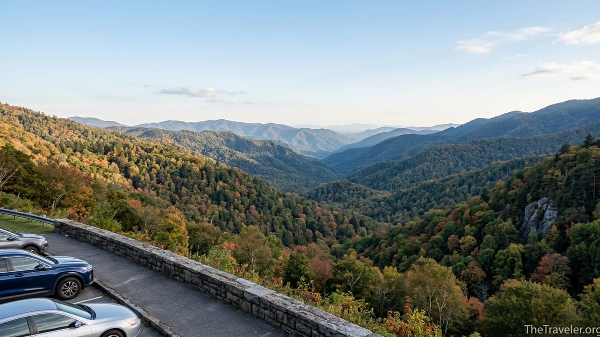
Scenic Driving: Newfound Gap Road and Overlooks
No one-day visit to Sugarlands feels complete without at least a short drive up Newfound Gap Road, the park’s main spine between Gatlinburg and Cherokee. Climbing from the Sugarlands area toward the high country, the road gains several thousand feet in elevation, with multiple signed overlooks and pullouts along the way. Many travelers choose a half-day loop: driving south from Sugarlands to Newfound Gap itself, stopping at a few viewpoints, then returning the same way.
Within the first several miles you will find broad roadside vistas into the Sugarlands valley and across to Mount Le Conte. Pullouts often fill fast in mid-day during peak leaf season, but patient circling or an earlier start usually nets a spot. From these overlooks you can see the patchwork of hardwood forests, steep ridges, and the thread of the highway curling up the slope below, which helps orient everything you have walked earlier in the day.
Newfound Gap, perched at over 5,000 feet, sits roughly at the state line between Tennessee and North Carolina. A large parking area, stone overlook walls, and interpretive signs describe the history of the pass and the establishment of the park. Even on warm days in Sugarlands, temperatures at the gap can feel significantly cooler, especially when fog and wind sweep across the ridge. If time permits, short excursions on the Appalachian Trail in either direction from the parking area offer quick forays into spruce fir forest before you return to your car.
Weather and seasonal closures can affect visibility and driving times, so before heading up it is wise to check conditions that morning with rangers at Sugarlands. Low clouds can obscure views for hours, while winter storms at higher elevations may briefly close stretches of the road to traffic. When conditions are clear, though, this drive gives you a dramatic sense of the Smokies’ vertical range in a relatively compact outing from your base in Sugarlands.
Historic Cabins and Quiet Corners Near Sugarlands
One of the understated pleasures of the Sugarlands area is how quickly you can step from the bustle of the visitor center or Gatlinburg Trail into quiet corners dotted with historic buildings. The short side trip to the John Ownby Cabin on the Fighting Creek Nature Trail is a prime example. Built in the late 1800s, the chestnut-log structure sits in a small clearing with a backdrop of mixed hardwoods, offering a tangible link to the subsistence farmers who shaped this valley’s early landscape.
Elsewhere near Sugarlands, you will notice long, low rock walls and occasional stone piles in the forest. These are not random; they are the remnants of old field boundaries and cleared plots, stacked by hand as farmers removed rocks from their land. Spending a few minutes reading interpretive signs and then looking carefully into the woods as you walk lends texture to your visit, turning what might appear to be undisturbed forest into a layered cultural landscape.
For those with time and energy for a longer hike, the Sugarland Mountain Trail begins not far from the Sugarlands area and climbs the spine of Sugarland Mountain toward higher country. Most day visitors sample only the lower portion before turning back, treating it as a quieter alternative to more crowded routes. The trail’s initial segments pass through rich forest with occasional filtered views back toward Gatlinburg and the valley, a reminder of how close the developed edge of the park sits to substantial wildness.
Between trailheads and pullouts, small roadside picnic spots along Newfound Gap Road make good bases for a simple lunch. While Sugarlands does not have a large, dedicated picnic area like some other parts of the park, spreading a blanket on the grass near the visitor center or claiming a table near the edge of the parking area can work well. Just be sure to store food promptly and dispose of trash in bear-resistant bins, both for your safety and to protect wildlife.
Connecting Sugarlands to Roaring Fork and Gatlinburg
Although the heart of Sugarlands lies within the national park boundary, its practical base is Gatlinburg only a short drive away. After you have explored the Sugarlands trails and perhaps driven up to Newfound Gap, consider extending your loop to include the Roaring Fork Motor Nature Trail on the eastern side of town. This one-way, seasonal road threads into a narrow, forested valley packed with historic buildings, stream views, and trailheads for popular hikes like Grotto Falls.
In a single afternoon, you might leave Sugarlands Visitor Center, stop for viewpoints on Newfound Gap Road, descend back toward Gatlinburg, drive across town, and enter Roaring Fork’s shaded corridor. The contrast is striking: where Sugarlands offers wide river valleys and quick access, Roaring Fork feels more enclosed and intimate, with the sound of the stream echoing between close hillsides. Old cabins, barns, and a grist mill appear at intervals beside the lane, each with parking pullouts and short paths for closer exploration.
Back in Gatlinburg, you will find the services that Sugarlands itself lacks: restaurants, coffee shops, gear stores, and lodging from simple motels to cabin rentals on the hillsides. Many visitors finish their day of hiking and driving with an early dinner in town before returning to their hotel or cabin. If you prefer to stay as close as possible to the park, choosing accommodations near the entrance or along River Road makes it easy to walk back into the park via the Gatlinburg Trail the next morning.
When planning your logistics, remember that peak seasons like midsummer and October weekends bring heavy traffic to both Gatlinburg and the park entrances. Building in extra time between Sugarlands and Roaring Fork, or considering an early-morning or late-afternoon foray rather than mid-day, can help keep the day enjoyable. Even on crowded days, the deeper you step onto footpaths like Sugarlands Valley Nature Trail or Fighting Creek, the faster the noise of traffic fades into birdsong and river sounds.
Planning a One-Day Sugarlands Itinerary
Because the Sugarlands area concentrates so many experiences within a compact radius, you can structure a satisfying one-day itinerary without a long drive or major elevation gain. A practical plan for a first visit might start with arriving at Sugarlands Visitor Center shortly after it opens, taking 30 to 45 minutes to see the exhibits, speak with a ranger, and use facilities. From there, you could walk the Fighting Creek Nature Trail loop with the detour to John Ownby Cabin, allowing about an hour at an easy, photo-friendly pace.
Late morning is a natural time to drive the short distance to the Sugarlands Valley Nature Trailhead and walk its half-mile accessible loop. With pauses to read signs, rest on benches, and appreciate the stream, many visitors spend 45 minutes to an hour here. Returning to the visitor center for a picnic lunch or snack lets you regroup and decide how ambitious you feel for the afternoon, factoring in weather and energy.
For the second half of the day, one option is to focus close to Sugarlands and walk an out-and-back along the Gatlinburg Trail, turning around after an hour or when you reach the edge of town. Another is to prioritize higher views and drive Newfound Gap Road, stopping at several pullouts and the gap itself before returning in time for an early evening meal in Gatlinburg. Ambitious travelers sometimes fit in both a partial Gatlinburg Trail walk and a shorter version of the Newfound Gap drive, but keeping a bit of margin in your schedule tends to make the day feel richer rather than rushed.
Practical details matter too. Sugarlands does not have fuel, so arrive with plenty of gas in your vehicle, especially if you intend to drive up to Newfound Gap or connect to other areas of the park. Bring rain layers even on sunny mornings, as mountain weather can change quickly; a compact umbrella or lightweight jacket can turn an unexpected shower on Sugarlands Valley Nature Trail into a pleasant, misty walk instead of a retreat to the car. With a modest daypack, comfortable walking shoes, and a flexible plan, you can experience a representative slice of the Smokies centered entirely around Sugarlands.
The Takeaway
For travelers with limited time, the Sugarlands area delivers a concentrated Smokies experience. Within a few miles of Sugarlands Visitor Center you can explore accessible forest paths, riverside walks, historic cabins, and high-elevation viewpoints on Newfound Gap Road. You never stray far from restrooms, ranger advice, or the services of Gatlinburg, yet the sense of being in real mountain country arrives quickly once you step onto the trails.
Whether you are pushing a stroller along the paved Sugarlands Valley Nature Trail, pausing at rock walls that once edged farmland, or watching clouds drift across ridgelines from Newfound Gap, the day feels full without being overwhelming. With one thoughtful visit built around Sugarlands, you gain not only pretty photographs but also a clearer feel for how people and landscape intertwine in this corner of the Great Smoky Mountains.
FAQ
Q1. Where exactly is the Sugarlands area located?
It sits just inside the northern boundary of Great Smoky Mountains National Park, immediately south of Gatlinburg, Tennessee, centered on Sugarlands Visitor Center and the nearby valley.
Q2. How much time do I need to see the main Sugarlands highlights?
A full day is ideal to visit Sugarlands Visitor Center, walk Sugarlands Valley Nature Trail and Fighting Creek, and either explore part of the Gatlinburg Trail or drive to Newfound Gap.
Q3. Is the Sugarlands Valley Nature Trail wheelchair accessible?
Yes, the loop is paved, relatively flat, and designed to be accessible for wheelchairs, mobility scooters, and strollers, with benches and interpretive signs along the way.
Q4. Can I bring my dog on the trails around Sugarlands?
Dogs on leash are allowed on the Gatlinburg Trail and in developed areas like parking lots and picnic spots, but they are not permitted on most other park trails, including Fighting Creek.
Q5. Do I need a reservation or permit to visit Sugarlands?
Day visitors do not need entry reservations, but vehicles stopping in the park longer than a brief pass-through typically need a valid parking pass, which can be purchased before or during your visit.
Q6. What is the best season to visit Sugarlands in one day?
Spring and fall offer cooler temperatures and vivid scenery, from wildflowers to fall colors. Summer is lush but busier, while winter can be quiet yet occasionally affected by snow and ice at higher elevations.
Q7. Are there food and lodging options right at Sugarlands Visitor Center?
No, the visitor center has restrooms, exhibits, and limited retail but no restaurant or lodging. For meals and overnight stays you will rely on nearby Gatlinburg or other communities outside the park.
Q8. Can I fit both Sugarlands and Roaring Fork into one visit?
Yes, many travelers tour Sugarlands and nearby trails during the morning and early afternoon, then drive the Roaring Fork Motor Nature Trail later in the day, especially in longer summer daylight.
Q9. What should I wear and bring for a one-day Sugarlands itinerary?
Wear comfortable walking shoes, layered clothing for changing mountain weather, and bring water, snacks, sun protection, rain gear, and a small daypack for maps, camera, and extra layers.
Q10. Is Newfound Gap Road always open from Sugarlands?
It is generally open year-round but can close temporarily in winter or during severe weather. Check current conditions with park staff at Sugarlands Visitor Center before driving to higher elevations.