
For many visitors, Sugarlands Visitor Center is simply a quick stop to grab a map, use the restroom, and continue to Newfound Gap or Cades Cove. Yet within a few miles of this busy hub in Great Smoky Mountains National Park lie some of the easiest to reach, least appreciated corners of the Smokies. From shaded “quiet walkways” that most drivers speed past, to little-known historic cabins and kid friendly riverside strolls, the Sugarlands area rewards anyone willing to linger. These are the hidden gems around Sugarlands that many travelers overlook.
Get the latest updates straight to your inbox!
Cataract Falls: A Short Stroll to a Pocket Waterfall
Just behind Sugarlands Visitor Center, a flat, family friendly path leads to one of the most accessible waterfalls in the park. The walk to Cataract Falls is roughly 0.7 to 1 mile round trip depending on where you start near the visitor center, with only gentle elevation changes and a hard packed surface that works for most strollers. You begin on a short sidewalk behind the building, then follow the shaded Fighting Creek Nature Trail through tulip poplar and hemlock forest until a signed spur leads to the falls.
What makes Cataract Falls a hidden gem is not that it is unknown, but that many people assume anything this close to the visitor center will feel crowded and underwhelming. In reality, if you start early in the morning or later in the afternoon, you may share the trail with just a handful of other visitors. The falls themselves are modest by Smokies standards, typically cascading about 20 feet over dark rock ledges, but the setting is intimate and photogenic. In spring, wildflowers cluster along the creek, and in midsummer the cool ravine can feel several degrees cooler than the parking lot.
From a practical standpoint, Cataract Falls is a perfect “arrival day” walk. If you have just driven in from Knoxville or farther afield and only have an hour before dinner in Gatlinburg, you can park at Sugarlands, stretch your legs, and be back at your car in 30 to 45 minutes. Because the trail starts right by the visitor center, you can also combine it easily with a stop at the bookshop or the small natural history museum inside, making this one of the easiest low effort, high reward excursions in the entire park.
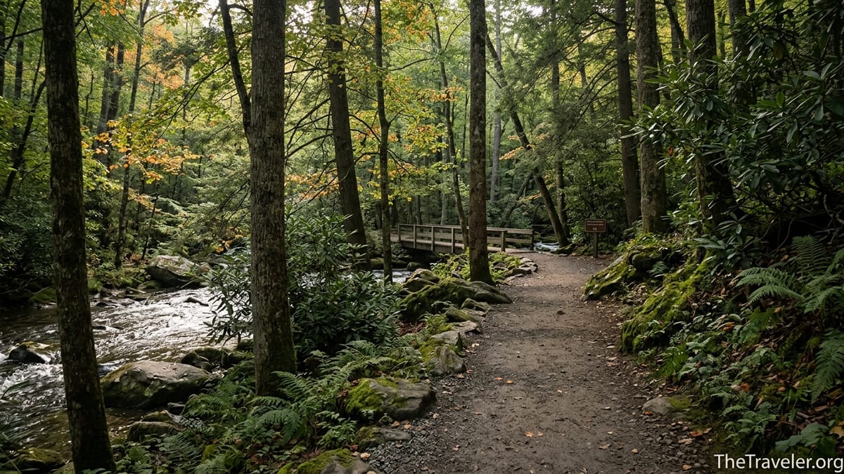
Fighting Creek Nature Trail and the John Ownby Cabin
Most people heading toward Cataract Falls walk only a short fragment of the Fighting Creek Nature Trail and never realize it forms a gentle loop with one of the park’s most evocative historic structures. The full loop is roughly a mile and begins from the same paved walkway behind the visitor center, but instead of peeling off to Cataract Falls you continue along the numbered posts of the self guided nature trail. Within minutes, the path passes under dense rhododendron tunnels and crosses a wooden footbridge over Fighting Creek.
About halfway around the loop, a short side path brings you to the John Ownby Cabin, a single pen log house dating from the late 1800s. Built by a member of one of the Sugarlands valley’s early farming families, the cabin stands today as a quiet reminder of the communities that existed long before the national park. Many visitors drive to larger historic areas like Cades Cove or Roaring Fork, yet this cabin sits less than 10 minutes’ walk from Sugarlands and is often completely empty even on busy weekends.
The trail’s interpretive signs explain how the surrounding forest has reclaimed old fields, point out tree species like black cherry and hemlock, and describe past land use. If you pick up a nature trail booklet at the visitor center desk for a few dollars, you can match each numbered post with a description for a more in depth experience. For families, the loop offers just enough variety to feel like a real Smokies hike without the commitment of a longer climb, and it is usually much quieter than well known destinations like Laurel Falls a few miles up the road.
The Gatlinburg Trail: A Riverside Ramble Few Walk End to End
Another overlooked option steps off right at Sugarlands but rarely gets more than a passing mention. The Gatlinburg Trail runs approximately 1.9 miles one way between Sugarlands Visitor Center and the edge of Gatlinburg, following the West Prong of the Little Pigeon River. Many travelers park in town and walk a short distance out and back, but treating this as a full point to point route reveals one of the gentlest and most scenic lower elevation walks in the park.
The path is relatively flat, wide, and partly hard packed gravel, making it approachable for novice hikers and children. It crosses a long footbridge with views up and down the river, and traces the remnants of old homesteads including stone walls and chimneys half hidden in the woods. Unusually for Great Smoky Mountains National Park, this is one of just two trails on the Tennessee side where dogs are allowed on leash, so it is especially valuable for travelers visiting with pets who still want a genuine park experience.
In practical terms, you can customize the Gatlinburg Trail to the time you have. A simple option is to park at Sugarlands, stroll a mile along the river, then return the same way for a relaxed two mile outing. If you have two vehicles, you might leave one in a Gatlinburg city lot near the park boundary and walk the full 1.9 miles one way in an hour or so. Even in peak seasons when the main park roads feel congested, sections of this riverside trail can remain surprisingly peaceful, particularly on weekday mornings or during shoulder months like late April and early November.
Quiet Walkways and Old Sugarlands Ruins Along Newfound Gap Road
Most drivers leaving Sugarlands quickly head up Newfound Gap Road toward the high country overlooks, rarely stopping for the small brown signs labeled “Quiet Walkway.” These pullouts hide some of the easiest access to the park’s old roadbeds, stone walls, and former farm sites. Within a mile or two of the visitor center, quiet walkways lead down to the West Fork of the Little Pigeon River and into the remnants of the old Sugarlands community, once home to dozens of families before the park was established.
These paths are intentionally short, typically under half a mile one way, and are not listed on many casual visitor maps. One common pattern is that traffic backs up at the Newfound Gap overlook and at Clingmans Dome, while these little parking areas sit nearly empty. On a summer afternoon when the main overlooks resemble theme park queues, you can pull off at a quiet walkway, step into cool shade, and in five minutes be standing beside moss covered foundations or listening to the river far from the noise of the road.
Because quiet walkways vary in condition and length, the best approach is to treat them as exploratory detours rather than major objectives. Pull off at one that has space, take note of your starting time, and walk until the path naturally ends at a riverbank or loop point. Many visitors find that even 20 minutes on one of these old lanes, with birdsong and the rush of water as the only soundtrack, offers a deeper sense of the Smokies than crowded marquee destinations. For photographers, low angle afternoon light filtering through the canopy along these walkways can yield rich, textured images without another person in the frame.
Historic Valley Sites: Noah “Bud” Ogle Farm and the Overlooked Sugarlands Past
Although technically just beyond the immediate Sugarlands crossroads, the historic farmsteads on Cherokee Orchard Road connect directly with the Sugarlands story. The Noah “Bud” Ogle Place, a short drive from the visitor center up a spur road from Gatlinburg, showcases a preserved late nineteenth century mountain farm with a log cabin, barn, and the remnants of an ingenious wooden “tub mill” on LeConte Creek. Many travelers rush past in search of the Rainbow Falls trailhead deeper up the road, leaving the farmstead relatively uncrowded outside of peak midday hours.
A self guided loop of roughly three quarters of a mile circles the Ogle homestead, passing split rail fences and a shaded stream valley that feels far removed from the bustle of downtown Gatlinburg only a few minutes away. Interpreted exhibits describe how farmers in the Sugarlands and neighboring valleys cultivated corn, maintained small livestock herds, and navigated the transition when the national park was created. Because the loop is short and only mildly uneven, it works well for families and anyone interested in local history but not up for a strenuous hike.
Back at Sugarlands, the small museum inside the visitor center expands on this history with artifacts, photographs, and seasonal ranger talks about the former communities in the valley. Travelers often bypass the exhibits on their way to the restrooms or the back door trail, but spending 20 to 30 minutes inside can enrich every walk you take in the surrounding forest. Suddenly those low mossy walls you see along a quiet walkway are not just scenic, but the last traces of someone’s yard or field.
Short Scenic Drives and Overlooks Few People Pause For
While major scenic routes like the Newfound Gap Road and the Roaring Fork Motor Nature Trail draw predictable crowds, there are smaller scenic pauses near Sugarlands that most visitors ignore. Just beyond the visitor center heading west toward the Townsend Wye, several pullouts overlook the Little River and its sparkling riffles. Many drivers use these only as quick photo stops, but with a folding camp chair or a picnic blanket you can turn them into a lingering break, listening to the water and watching for the occasional belted kingfisher or merganser.
Another underappreciated option begins just a short distance from Sugarlands where the Gatlinburg Bypass branches off toward town. The bypass itself is designed to route traffic around downtown, yet it offers a developed overlook with a sweeping view over Gatlinburg, Mount LeConte, and the Sugarlands valley. Because many travelers stay on the main park road, this overlook can be notably less crowded than Newfound Gap, especially early and late in the day. It is an easy add on before or after a visit to Sugarlands, requiring only a brief detour and a short walk from your parked car.
For visitors willing to drive a bit farther, continuing west from Sugarlands on Little River Road reveals additional bends in the river, roadside cascades, and pullouts that tend to be quieter than the more publicized Laurel Falls parking area. You can craft a relaxed half day itinerary by visiting Sugarlands early, enjoying a short trail such as Cataract Falls, then slowly following Little River Road toward Metcalf Bottoms, stopping wherever a pullout catches your eye.
Seasonal Surprises: Wildflowers, Fall Color and Winter Quiet
The Sugarlands area changes dramatically with the seasons, which means certain lesser known spots shine at specific times of year. In April and early May, the woods behind the visitor center host carpets of wildflowers, from trillium and spring beauty to showy stands of fringed phacelia near streams. A small but carefully planted pollinator garden near Sugarlands, laid out with native species like scarlet beebalm and New England aster, offers an easy wildflower fix for those with limited mobility or time.
By late October, while crowds cluster at the high overlooks around Newfound Gap and Clingmans Dome, mid elevation forests around Sugarlands are often near peak color. The mix of sugar maple, hickory and birch along trails like Fighting Creek and the Gatlinburg Trail can rival better known vistas, yet allow you to experience the leaves at eye level. On cool, clear afternoons, you might walk through golden tunnels of foliage with only the sound of your footsteps and the river nearby.
Winter is the ultimate hidden season in this area. Although Sugarlands Visitor Center remains a key access point even in colder months, many casual visitors stay closer to town, assuming trails will be icy or closed. In reality, lower elevation paths like the Gatlinburg Trail and many quiet walkways often remain passable with only occasional patches of snow or frost. With leaves off the trees, old stone walls and cabin sites become easier to spot, and the views through the forest open up, giving a different sense of scale to the surrounding ridges.
Planning Tips for Enjoying Sugarlands’ Quieter Corners
To make the most of these hidden gems, timing and expectations matter more than secret spots. Arriving at Sugarlands Visitor Center close to opening time often means easier parking and more relaxed walks on nearby trails. In peak summer, midday hours tend to be warm and busy, so consider structuring your day with an early hike near Sugarlands, a midday break back in Gatlinburg or Pigeon Forge, and a return in late afternoon for a quiet walkway or riverside stroll.
Weather is another key consideration. Sudden storms can swell creeks quickly, making some low riverbank paths muddy or temporarily unsafe, while fog can obscure long range views but create beautifully atmospheric conditions in the forest. A waterproof jacket, light layers, and shoes with decent traction are usually sufficient for the short trails around Sugarlands, though hiking poles can be useful on rooty sections of the Gatlinburg Trail or when exploring lesser maintained quiet walkways.
Parking near Sugarlands can fill on popular weekends and holidays, particularly during peak fall color and wildflower seasons. If the main lot is crowded, patience pays off; visitors are constantly coming and going, and spaces usually open within 10 to 15 minutes. Alternatively, you can sometimes park in Gatlinburg and walk into the park on the Gatlinburg Trail, turning the parking challenge into part of the adventure. Whatever your approach, treating the Sugarlands area as a place to linger, not just to pass through, reveals layers of landscape and history that many road based travelers never notice.
The Takeaway
The Sugarlands area of Great Smoky Mountains National Park is often overshadowed by headline destinations deeper inside the park. Yet within a couple of miles of the visitor center, you can reach a pocket waterfall, wander past an historic log cabin, follow an easy riverside path with your dog, and step into quiet forest lanes that once served a thriving mountain community. None of these outings require advanced hiking skills or a full day’s time commitment, only a willingness to slow down and step away from the main flow of traffic.
Whether you are visiting the Smokies for the first time or returning for the tenth, rethinking Sugarlands as more than a brief stop can transform your trip. Start your day with a lap around the Fighting Creek Nature Trail, pause to study the exhibits inside the visitor center, wander a quiet walkway along the West Fork of the Little Pigeon River, then watch the evening light from a pullout on the Gatlinburg Bypass. In doing so, you will discover that some of the park’s richest experiences often begin right where most visitors think their journey is just getting started.
FAQ
Q1. How far is Cataract Falls from Sugarlands Visitor Center and how long does it take?
The walk to Cataract Falls from Sugarlands Visitor Center is roughly 0.7 to 1 mile round trip depending on your exact starting point and usually takes 30 to 45 minutes at a leisurely pace.
Q2. Is the Gatlinburg Trail suitable for beginners and families with children?
Yes. The Gatlinburg Trail is relatively flat, about 1.9 miles one way, and follows the river on a wide path, making it a good choice for novice hikers and families with school age children.
Q3. Are dogs allowed on any of the trails near Sugarlands?
Dogs on leash are allowed on the Gatlinburg Trail between Gatlinburg and Sugarlands Visitor Center. Most other trails in this part of the park, including Fighting Creek Nature Trail and Cataract Falls, do not permit pets.
Q4. What is a “quiet walkway” and where can I find one near Sugarlands?
A quiet walkway is a short, signed path designed for peaceful forest walks away from heavy traffic. Several begin from small pullouts along Newfound Gap Road within a few miles of Sugarlands Visitor Center, often leading to old home sites or the river.
Q5. Is there an easy historic site to visit close to Sugarlands?
Yes. The John Ownby Cabin sits on a short spur off the Fighting Creek Nature Trail just behind Sugarlands Visitor Center, and the Noah “Bud” Ogle farmstead is a short drive away on Cherokee Orchard Road with its own easy walking loop.
Q6. When is the best time of day to explore the trails around Sugarlands?
Early morning and late afternoon generally offer cooler temperatures, softer light and fewer people. Midday can be busier and warmer, especially in summer and on fall weekends.
Q7. Do I need special hiking gear for these shorter Sugarlands area trails?
For most visitors, comfortable walking shoes, a light daypack, water and weather appropriate layers are sufficient. Trekking poles can be helpful but are not essential for the relatively gentle terrain around Sugarlands.
Q8. Can I see good fall colors without driving far from Sugarlands?
Yes. Trails like Fighting Creek Nature Trail and the Gatlinburg Trail, as well as nearby quiet walkways, pass through mixed hardwood forests that show excellent fall color, often peaking in late October around this elevation.
Q9. Is Sugarlands Visitor Center a good first stop for Smokies first timers?
It is one of the best starting points, with restrooms, a small museum, park maps, ranger staffed information desks and several short trails beginning right outside the doors, making orientation easy even for first time visitors.
Q10. What is a realistic half day itinerary that focuses on hidden gems near Sugarlands?
A practical half day plan is to arrive at Sugarlands early, walk the Fighting Creek Nature Trail loop with the John Ownby Cabin, continue to Cataract Falls, spend some time in the visitor center museum, then drive a short distance to explore one or two quiet walkways along Newfound Gap Road or enjoy the view from the Gatlinburg Bypass overlook.