
Every day in peak season, carloads of visitors stream through Sugarlands Visitor Center on their way to Newfound Gap, Clingmans Dome, and Gatlinburg’s neon glow. They dash inside for a map, a restroom stop, maybe a quick question at the information desk, then merge back into the traffic on Newfound Gap Road. What many of them never realize is that within a short walk of that crowded parking lot lie quiet forests, hidden waterfalls, and traces of the mountain communities that stood here long before Great Smoky Mountains National Park was created.
Get the latest updates straight to your inbox!
Why Sugarlands Is More Than Just a Quick Pit Stop
Sugarlands Visitor Center sits just inside the park boundary near Gatlinburg, Tennessee, and serves as one of the main gateways to Great Smoky Mountains National Park. It offers park maps, exhibits, a small bookstore, restrooms, and a short orientation film about the Smokies. For road trippers arriving from Interstate 40 or families staying in Gatlinburg, this is the natural first stop, and the large parking lot can feel more like a highway rest area than a wilderness trailhead.
Because of that highway atmosphere, many travelers treat Sugarlands purely as a logistical stop. They pick up a paper map, ask a ranger how to reach Laurel Falls or Clingmans Dome, and leave within 20 minutes. Tour buses cycle in and out. Drivers keep engines idling while passengers stretch their legs. It is easy to assume that the real park only begins miles deeper in the mountains.
The reality is very different. Within a half-mile of Sugarlands Visitor Center, several trails fan out into cove hardwood forest, along streambanks, and past the remains of homes, mills, and stone walls from the former Sugarlands community. Short loops like Cataract Falls and Fighting Creek Nature Trail start almost from the front door. Longer hikes such as the Gatlinburg Trail and Old Sugarlands Trail begin nearby and can keep you exploring all day without ever moving your car. Those who blow past the visitor center miss a chance to discover the Smokies at a slower, quieter pace.
If you plan carefully, you can turn Sugarlands itself into a half- or full-day mini-itinerary. Start with the exhibits, walk to a waterfall, explore a historic cabin, and still be back in Gatlinburg in time for dinner. For first-time visitors with limited time, this compact cluster of trails provides a surprisingly rich introduction to what makes the Smokies special.
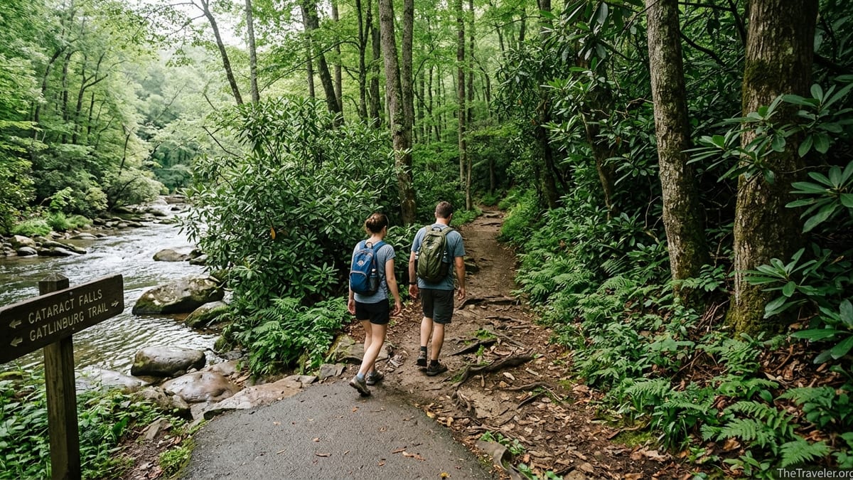
Stepping Off the Pavement: Cataract Falls and Fighting Creek
The most overlooked experience at Sugarlands may also be the easiest to reach. Walk out the front doors of the visitor center, follow the signs toward the nature trails, and in a few minutes you are under a shaded canopy of tulip poplars, hemlocks, and rhododendrons. The 0.7-mile walk to Cataract Falls follows Fighting Creek on a mostly level path that feels far removed from the busy parking lot even on a Saturday in July.
Cataract Falls itself is a slender, roughly 40-foot cascade spilling through a mossy rock cleft, often framed by overhanging branches. After heavy rain it becomes a lively, photogenic sheet of water; in late summer it can shrink to a delicate veil. Either way, it is an excellent introduction to Smokies waterfalls for families with young children or visitors who cannot tackle steeper terrain. Many people will wait in line for parking at Laurel Falls later in the day without realizing they passed a quieter waterfall within a five-minute walk of Sugarlands.
Branching from the same area, the self-guided Fighting Creek Nature Trail forms a modest loop through the forest. Numbered posts correspond to a brochure available at the visitor center, explaining how the forest is regenerating after logging and farming, and identifying plants such as doghobble, galax, and rhododendron in plain language. This is a gentle, real-world classroom: you might pause to read about cove hardwood ecology while listening to wood thrushes or spotting salamanders near damp logs.
Along the loop stands the historic John Ownby Cabin, a hand-hewn log home dating from the late 19th century that was once part of a small mountain farm. Walking through its doorway and peering at the single large room helps visitors imagine life here before the national park existed. For many travelers, this is their first close-up encounter with the human history of the Smokies, and it happens just a short stroll from the visitor center lobby.
The Accessible Gem: Sugarlands Valley Nature Trail
A few minutes by car from Sugarlands Visitor Center along Newfound Gap Road is another underappreciated stop: the Sugarlands Valley Nature Trail. This half-mile paved loop meanders through a cove forest beside the West Prong of the Little Pigeon River and is specifically designed to be accessible. It is flat, wheelchair-friendly, and often used by visitors with mobility challenges or families pushing strollers.
Despite its modest length, the trail passes stone walls, remnants of chimneys, and low rock foundations that hint at the farms and homesteads that once occupied this valley. Interpretive signs describe how families raised corn, tended orchards, and built water-powered mills long before the land was incorporated into the national park. Standing beside a moss-covered chimney while hearing the river tumble nearby can be just as powerful as gazing out from a high overlook.
The National Park Service has assessed this loop to ensure it meets specific accessibility standards, and specialized all-terrain wheelchairs, such as GRIT Freedom Chairs, are sometimes available from the park for visitors who reserve them in advance. That level of planning reflects how seriously the park takes the goal of opening Smokies scenery to a broader range of people. The Sugarlands Valley Nature Trail is an ideal place for multi-generational families where some members may be hiking Alum Cave while others prefer a peaceful, level walk.
In practical terms, this is also a welcome break from crowded parking areas elsewhere in the park. While trailheads such as Laurel Falls often overflow with cars late in the morning, Sugarlands Valley frequently has open spaces and a quieter feel. Adding this loop to a morning that starts at Sugarlands Visitor Center allows travelers to experience river sounds, filtered light, and a sense of the former community without committing to a strenuous hike.
Following the River to Town: The Gatlinburg Trail
From just behind Sugarlands Visitor Center, the Gatlinburg Trail heads roughly two miles along the West Prong of the Little Pigeon River toward the city. This relatively flat path is one of only two trails in Great Smoky Mountains National Park where dogs are allowed on leash, which makes it especially popular with visitors staying in pet-friendly cabins or hotels in Gatlinburg. It also serves as a practical, scenic walking route between town and the park.
Early in the morning, you might see local runners using the trail for a workout, couples carrying coffee cups from their Gatlinburg lodgings, or photographers setting up tripods by the riverside. The path crosses footbridges, passes stone walls and the remains of old homesteads, and offers frequent access points where children can carefully reach the water’s edge under adult supervision. In autumn, fallen leaves collect in quiet backwaters, creating reflections of orange and gold.
For many families, walking from downtown Gatlinburg to Sugarlands Visitor Center on the Gatlinburg Trail and then adding the short Cataract Falls or Fighting Creek loop creates a full morning of easy hiking. You can explore exhibits at the visitor center, talk with a ranger about wildlife sightings, and then wander back to town on foot, avoiding the hassles of re-parking during busy times. This kind of low-stress itinerary is exactly what many rushed visitors overlook when they drive straight past the trailhead on their way up Newfound Gap Road.
The trail also provides a valuable safety valve during peak season. When popular destinations such as the Alum Cave trailhead are full by mid-morning, travelers who are flexible can pivot to the Gatlinburg Trail and still enjoy a satisfying river walk without spending an hour circling for parking. In a park where congestion is increasingly common, understanding options that start right at Sugarlands can transform an otherwise frustrating day.
Into Quieter Country: Old Sugarlands Trail and Beyond
For hikers looking for more solitude without a long drive, the Old Sugarlands Trail is perhaps the most surprising discovery near Sugarlands. Despite starting near one of the busiest visitor centers in the national park, this former roadbed sees far fewer people than marquee hikes deeper in the park. It connects the Sugarlands area with Cherokee Orchard Road, passing through second-growth forest and past subtle traces of the pre-park community.
The trail is generally wider and less steep than many mountain paths, making it accessible for intermediate hikers who are comfortable with a longer distance but prefer a moderate grade. Along the way, you may spot remnants such as stone foundations, old road cuts, and abandoned drainage ditches that hint at how this route once carried wagons and early automobiles. In spring and early summer, wildflowers and rhododendron blooms add color to the forest floor.
Because Old Sugarlands receives less attention in guidebooks than famous routes like Chimney Tops or Alum Cave, it often provides relative quiet even on busy weekends. Local hiking clubs sometimes use it as part of loops that combine Old Sugarlands with trails such as Twin Creeks or the Gatlinburg Trail, creating all-day adventures that begin and end at Sugarlands Visitor Center. For visiting hikers who ask rangers at the desk for “something less crowded but still convenient,” this is often one of the first suggestions.
Old Sugarlands also connects conceptually to longer backcountry routes radiating from the Sugarlands area, including the Sugarland Mountain Trail and the Cove Mountain Trail system. Ambitious backpackers can string together multi-day trips that begin within sight of the visitor center parking lot and end far across the park at locations like Deep Creek near Bryson City. While that is far beyond what most casual visitors will attempt, it underscores how Sugarlands can be both a front-country hub and a gateway to deep wilderness.
Reading the Landscape: Hidden History in the Forest
One of the most compelling reasons to slow down at Sugarlands is the chance to read the human story written across the surrounding hillsides. Before the establishment of Great Smoky Mountains National Park in the 1930s, this valley was home to a small but active farming community. Residents built homes, churches, schools, and mills; they grew corn, cut hay, and kept livestock on cleared slopes that today appear as unbroken forest.
Many visitors drive through the area assuming the forest has always looked this way. By walking trails such as Fighting Creek or the Sugarlands Valley Nature Trail, you begin to notice clues that tell a different story. A seemingly random line of stacked stones reveals the edge of a former field. A patch of non-native daffodils blooming in early spring marks the site of a long-vanished front yard. A flat terrace above the creek, now shaded by maples and poplars, was once a small pasture or garden.
The exhibits inside Sugarlands Visitor Center expand on these hints with photographs and artifacts. You might see a hand-forged plowshare or black-and-white family portrait, then step outside to view the same ridgeline in the background, now softened by decades of regrowth. The short films and displays explaining how land was acquired for the park help visitors develop a more nuanced understanding of both the sacrifices and the benefits involved in creating a protected landscape of this scale.
Spending even an hour connecting those indoor exhibits to real-world locations on nearby trails can change how you experience the rest of the park. Suddenly Cades Cove, Elkmont, and Cataloochee are not just scenic valleys but places where communities once debated the same choices as residents of Sugarlands. Travelers who never move beyond the parking lot rarely gain that deeper context.
Planning a Sugarlands-Based Half-Day Itinerary
Making the most of Sugarlands does not require complex planning. A realistic half-day itinerary might start with arriving at the visitor center around opening time, when the parking lot is less crowded. After a quick stop at the information desk to confirm current trail conditions and any temporary closures, you can spend 20 to 30 minutes exploring the nature exhibits and browsing the bookstore for a simple field guide or historic map.
From there, head directly to the Cataract Falls and Fighting Creek loop. Allow about an hour to walk at a relaxed pace, stop for photos at the falls, and linger at the John Ownby Cabin. Families with small children may want extra time for creekside play in safe spots near the trail, always supervising closely and watching water levels after recent rain. Upon returning to the visitor center, take a brief break at the picnic tables or in your car for snacks.
Next, drive a short distance to the Sugarlands Valley Nature Trail parking area along Newfound Gap Road for another 30 to 45 minutes of easy strolling. This loop gives everyone in the group, regardless of mobility level, a chance to experience the sound of the river and glimpse remnants of the old community. On the way back toward Gatlinburg, you can decide whether to stop at a roadside overlook or continue into town for lunch.
Alternatively, visitors staying in Gatlinburg might reverse the order. Start in town, walk the Gatlinburg Trail to Sugarlands, explore the exhibits and Cataract Falls, then return on foot. This approach eliminates the need to find parking at the visitor center on a crowded afternoon and turns transportation into part of the day’s scenic experience. In all of these scenarios, you are building a meaningful Smokies visit primarily around Sugarlands instead of treating it as a brief detour.
The Takeaway
Sugarlands Visitor Center may look like just another waystation on the road into Great Smoky Mountains National Park, but the surrounding trails and historic sites offer far more than a quick restroom break. Within a mile of the parking lot you can stand at the base of a waterfall, step into a 19th-century log cabin, follow a river toward town, or trace stone walls that once bordered family farms. These experiences require only modest time and effort, yet they reveal the layered natural and cultural history that defines the Smokies.
Most travelers pass through Sugarlands focused on distant destinations with famous names. They might still have a memorable trip, but they miss the chance to let the park introduce itself gently right at the gateway. By slowing down, stepping off the pavement onto nearby paths, and treating Sugarlands as a destination in its own right, you can turn a standard park orientation stop into one of the most rewarding parts of your visit.
FAQ
Q1. Where exactly is Sugarlands Visitor Center located?
It sits just inside Great Smoky Mountains National Park near Gatlinburg, Tennessee, at the northern end of Newfound Gap Road, making it a primary entry point for visitors coming from the Gatlinburg area.
Q2. How much time should I plan to spend at Sugarlands if I want to see more than the exhibits?
Plan at least two to four hours if you want to explore the exhibits, walk to Cataract Falls or along Fighting Creek, and add either the Sugarlands Valley Nature Trail or part of the Gatlinburg Trail.
Q3. Are the trails near Sugarlands suitable for young children and beginners?
Yes. Cataract Falls, Fighting Creek Nature Trail, and the Sugarlands Valley Nature Trail are short, mostly gentle routes that work well for families, first-time hikers, and visitors who prefer easy terrain.
Q4. Is there an accessible trail near Sugarlands for visitors with limited mobility?
The Sugarlands Valley Nature Trail, a half-mile paved loop near the visitor center, is designed to be wheelchair-friendly and provides river views, forest scenery, and glimpses of historic remains.
Q5. Can I bring my dog on the trails by Sugarlands?
Dogs on leash are allowed on the Gatlinburg Trail, which begins near the visitor center and runs toward town. Other nearby trails such as Cataract Falls, Fighting Creek, and Old Sugarlands do not allow pets.
Q6. What is a good less-crowded hike that starts close to Sugarlands?
Old Sugarlands Trail offers a quieter, moderate outing. It follows an old roadbed through forest and past subtle historic sites, connecting the Sugarlands area with Cherokee Orchard Road.
Q7. Do I need any permits or passes to park at Sugarlands?
Great Smoky Mountains National Park now requires a parking tag for vehicles parked more than a brief period, and Sugarlands Visitor Center is one of the places where visitors typically display those tags while they explore.
Q8. Is Sugarlands a good place to start if I only have one day in the Smokies?
Yes. Starting at Sugarlands lets you get current information from rangers, watch a short orientation film, and access several easy-to-moderate hikes without spending time driving deeper into the park.
Q9. What should I ask rangers at Sugarlands to make the most of my visit?
Ask about current trail conditions, any temporary closures, recent wildlife activity, and suggestions for less-crowded hikes that match your group’s abilities and the time you have available.
Q10. Can I use public transportation or shuttles to reach Sugarlands from Gatlinburg?
Options change over time, but many visitors either drive themselves or walk the Gatlinburg Trail from town. Before your trip, check with Gatlinburg visitor information or local operators for any current shuttle services.