
It was only when I crossed Plaça de Catalunya on foot, at an unhurried late-morning pace, that Barcelona’s geography finally clicked. The square felt less like a sightseeing stop and more like the operating system of the city. Metro lines pulsed underneath, airport buses unloaded new arrivals, and a web of streets radiated toward beaches, hills, and medieval alleys. By the time I had circled its fountains and statues, I could suddenly visualize how the Gothic Quarter, Eixample, Passeig de Gràcia, and La Rambla all locked into place.
Get the latest updates straight to your inbox!
The Square Where Old Barcelona Meets the New
Plaça de Catalunya sits exactly where Barcelona’s medieval core ends and its 19th century expansion begins. Stand on the southern edge of the plaza and you are looking into the narrow streets of the Gothic Quarter and El Raval. Turn north, and the strict grid of the Eixample district stretches away in long straight lines. City planners could not have drawn a clearer border if they had tried, and you can feel this change under your feet as you walk from shaded, irregular alleys into broad, sunlit avenues.
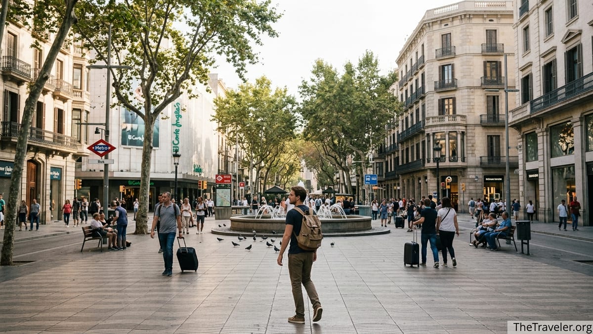
The square itself is large, roughly five hectares of open space marked by fountains, statues, and flocks of pigeons. Around its edges rise department stores like El Corte Inglés and triangle-shaped commercial buildings that point toward the great boulevards. Several of Barcelona’s main arteries converge here, including La Rambla, Passeig de Gràcia, Rambla de Catalunya, and Portal de l’Àngel. Simply by standing at one of the central fountains and turning a slow circle, you can see the main directions in which the city flows.
Plaça de Catalunya’s role as the city’s core is not just symbolic. Local tourism authorities describe it as the meeting point between Ciutat Vella, the Old City, and the Eixample. For a first-time visitor, that description is more helpful than any abstract map. If you tell yourself that everything south and east of the square tends to be older, denser, and more medieval, and everything north and west is newer, wider, and more rationally planned, you suddenly have a mental filter for nearly every walk you take.
The square’s history reinforces this hinge role. Before the 19th century it was an open esplanade outside the city walls. When those walls came down and the Eixample was built in a rigid grid, planners turned this space into a formal plaza. Walking across it today, you are literally crossing the seam between two urban eras.
Reading Barcelona’s Map With Your Feet
Paper maps and apps show Barcelona as a collage of neighborhoods, but Plaça de Catalunya lets you understand it as a set of axes. One axis runs roughly north to south, from the hills to the sea, along Passeig de Gràcia, La Rambla, and the continuation of that line down to the Columbus Monument. Another runs west to east, from the broad boulevards of Eixample toward the Gothic Quarter and on toward the waterfront. When you walk across the square, you physically feel those two main directions intersect.
Take, for example, the short walk from the plaza’s central fountains to the mouth of La Rambla on the southwest corner. It is only a couple of minutes, but emotionally it feels like a gateway. One moment you are in open space, surrounded by traffic circles and office towers. The next, you are pulled into the tree-lined, tourist-heavy promenade that slopes gently toward the sea. Glance left and you see the side streets of El Raval; glance right and you catch a glimpse of the Gothic Quarter. This is the southern flow of the city compressed into a single turn.
Now cross to the northeast corner and step toward Passeig de Gràcia. The mood shifts again. Instead of street performers and flower stalls, there are luxury boutiques, wide sidewalks, and stately facades. Look up and you will spot the tops of modernist buildings, including the direction where Casa Batlló and La Pedrera lie further north. In a walk of less than five minutes, you have moved from the medieval past (Gothic Quarter), through the civic present (Plaça de Catalunya), to the bourgeois modernity of Eixample.
Repeat this walk at different times of day and the city’s patterns become even clearer. Morning commuters streaming out of metro entrances make it obvious that this is a transport hub. In the late afternoon, shoppers dominate the Portal de l’Àngel side, heading toward mid-range fashion chains and small side-street boutiques. After dark, streams of people flow from the plaza into El Raval and the Gothic Quarter in search of tapas bars and late-night plazas. By keeping Plaça de Catalunya as your anchor, all these movements make sense.
What Lies Beneath: Metro Lines, Trains, and Airport Links
Much of Plaça de Catalunya’s power lies underground. The square is one of Barcelona’s busiest transit interchanges, with metro, suburban trains, regional lines, and airport buses layered beneath the surface. Understanding this tangle is far less intimidating if you visualize it while standing on the paving stones above.
Directly underneath the plaza is Catalunya station, where the red metro line L1 and the green line L3 intersect with FGC-operated lines L6 and L7, as well as commuter trains on the R lines. Train maps confirm that this is one of the network’s core transfer points, with lines faning out toward suburbs like Terrassa and Sabadell in one direction and toward waterfront districts and other central hubs in the other. In practical terms, this means you can step off a suburban train from the Vallès region, walk a few meters inside the station, and be on the metro to the Gothic Quarter or Sants in minutes.
To feel how this shapes the city, watch the flow at the Aerobus stop on the southeast side of the square. This blue airport bus line runs frequently throughout the day, connecting both terminals of Barcelona–El Prat Airport with Plaça de Catalunya and several intermediate stops such as Plaça Espanya and Plaça Universitat. Recent route information notes that Plaça de Catalunya remains the key city-center terminus, even when temporary relocations are required during construction works elsewhere. For travelers, this makes the plaza not just a symbolic center but a literal arrival point. Many first steps in Barcelona are taken here, suitcase wheels rattling on the pavement.
Average transit prices reinforce the hub concept. A standard integrated ticket for the central fare zone typically covers metro, city buses, and some commuter rail for about the cost of a coffee and pastry, while airport bus tickets cost a bit more for the dedicated service. Because multiple systems intersect at Plaça de Catalunya, you can use that single card or mobile ticket to transfer from, say, a metro ride from Sagrada Família to a bus heading toward the beach, with the plaza as your pivot point.
This concentration of connections explains why local residents often suggest meeting “at Catalunya” when heading out together, even if no one plans to linger in the square itself. From here, friends can fan out in any direction on foot or by metro, choosing between dinner in Gràcia, drinks in El Born, or a concert further up in the Eixample grid.
North to the Grid: Eixample and Passeig de Gràcia
Walking north from Plaça de Catalunya across Ronda de Sant Pere, the streets reorganize themselves into the iconic Eixample grid. You feel the change immediately. The corners are chamfered, buildings rise in more uniform heights, and straight streets stretch away until they vanish at the horizon. This is the 19th century plan that turned Barcelona into a modern city, and you can treat the plaza as square zero of this grid.
Follow Passeig de Gràcia north for just ten minutes and you reach Casa Batlló and, further along, Casa Milà (La Pedrera), two of Gaudí’s most famous works. On the way, you pass flagship boutiques and office buildings that line the wide sidewalks. The distance is walkable even with a coffee in hand, and because you began at Plaça de Catalunya, you always know that turning back south will return you to the city’s effective center.
On either side of Passeig de Gràcia, the Eixample grid offers a more local scale of discovery. Streets like Carrer de Pau Claris or Rambla de Catalunya run roughly parallel to Passeig de Gràcia but feel quieter and more residential. As you walk these, it helps to remember that their numbering and layout all refer back to the grid’s origin near Plaça de Catalunya. If you ever get disoriented, walking downhill and toward the sea will usually bring you back within a few blocks of the plaza.
The metro reinforces this northward understanding. From Catalunya station, L3 runs under parts of Passeig de Gràcia toward Sants and further, while L1 cuts across the grid east to west. FGC lines L6 and L7 begin here and run toward neighborhoods such as Sarrià and Avinguda Tibidabo. Stand at the northern edge of Plaça de Catalunya during rush hour and you will see this system in motion: business travelers heading toward office districts in Eixample, students aiming for universities up the hill, and tourists making for Gaudí’s masterpieces.
South to the Sea: La Rambla, the Gothic Quarter, and El Raval
If Eixample is the rational face of Barcelona, the neighborhoods south of Plaça de Catalunya are its tangle of memory. Step from the plaza into La Rambla, and you are entering a gentle slope toward the Mediterranean. Even if you never make it all the way to the Columbus Monument, the direction is obvious. This axis explains why so many walking itineraries start at Plaça de Catalunya before descending toward the sea through the city’s oldest streets.
Turn slightly southeast at the base of the square and you reach Portal de l’Àngel, a busy shopping street that dives directly into the Gothic Quarter. A simple ten or fifteen minute walk from the plaza can bring you to Barcelona Cathedral, Plaça del Rei, or Plaça Sant Jaume. Travelers who walk this route rather than taking the metro often remark that it suddenly makes sense how close the medieval core lies to the modern center. From a map, those twisting alleys can look remote. From Plaça de Catalunya’s paving stones, they are just around the corner.
On the southwest side, beyond La Rambla, lies El Raval, long known as a working-class and immigrant neighborhood. From the plaza, you can reach the top of this district in under ten minutes on foot, arriving at cultural landmarks like the MACBA contemporary art museum or the CCCB cultural center. Here, again, the plaza functions as a reference: you know that crossing La Rambla westward pushes you deeper into Raval, while keeping La Rambla on your right while walking south keeps you closer to the Gothic Quarter.
For many visitors, this mental map proves most useful late in the evening, when narrow streets and busy tapas bars can make orientation tricky. Remembering that Plaça de Catalunya sits at the uphill, inland end of the main corridor to the sea allows you to navigate by feel. If you find yourself among Gothic church spires or in a crowded plaza near La Rambla, walking uphill and following the subtle increase in slope usually brings you back to the square within twenty to thirty minutes.
Distances, Timing, and How Walkable the Center Really Is
Spending a day with Plaça de Catalunya as your anchor quickly reveals just how compact central Barcelona is. Many key sights sit within a one to two kilometer radius, which translates to roughly fifteen to thirty minutes on foot for most travelers. From the plaza, for instance, reaching Casa Batlló on Passeig de Gràcia typically takes around ten minutes walking at a relaxed pace. Continuing to La Pedrera adds only another seven or eight minutes.
In the opposite direction, walking from Plaça de Catalunya down La Rambla to the Columbus Monument tends to take about twenty minutes without extended stops. Detouring into the Gothic Quarter to visit the cathedral or Plaça del Rei adds only a few minutes more. These distances explain why many seasoned visitors recommend exploring the historic core largely on foot, using the metro only for jumps between more distant areas like Sagrada Família, Montjuïc, or the beaches.
The plaza’s centrality also simplifies multi-stop days. You might spend a morning in the Gothic Quarter, return to Plaça de Catalunya for lunch in a nearby Eixample cafe or at the food counters inside a department store, then head north along Passeig de Gràcia in the afternoon to tour Gaudí’s houses. Because each leg begins or ends at the same square, it becomes easier to estimate your energy and decide when to switch from walking to public transport.
Of course, walkability also depends on surfaces and slopes. The areas immediately north and south of Plaça de Catalunya are mostly flat, with wide sidewalks and frequent crossings. This makes the square a comfortable starting point even for travelers with moderate mobility limitations. Hills become more pronounced as you move farther north toward Gràcia or west toward Montjuïc, but within the inner ring around the plaza, gradients are gentle and distances manageable.
How Locals Use Plaça de Catalunya (and How Travelers Can Too)
For Barcelonans, Plaça de Catalunya is less a place to linger than a place to pass through. Office workers cut across it on their way from Eixample apartments to jobs in the Gothic Quarter. Students hop off suburban FGC trains and change to the metro lines toward university campuses. Friends agree to meet “under the clock” near one of the department store entrances before heading elsewhere for dinner or drinks. Observing these patterns helps visitors adopt the same efficient habits.
Travelers arriving from the airport often emerge from the Aerobus or train at Plaça de Catalunya and immediately head to other neighborhoods. With a small bag, you might walk straight from the square to your Gothic Quarter hotel, following Portal de l’Àngel and diving into the medieval grid. Others wheel suitcases up toward Passeig de Gràcia, where many mid-range and high-end hotels cluster along or near the boulevard. The plaza thus becomes both a first impression and a practical junction.
You can also use Plaça de Catalunya as a low-effort orientation exercise. Spend half an hour there on your first afternoon in the city, walking slow loops from one corner to another. On one circuit, focus on identifying the start of La Rambla and the direction of the sea. On another, trace the line of Passeig de Gràcia and notice the change in architecture as you approach its first blocks. On a third loop, find the entrances to the metro and FGC stations and note which lines run where. This simple practice walk does more to demystify Barcelona’s layout than many hours scrolling through maps.
Finally, the plaza serves as a psychological safety net. Knowing that nearly every major metro or bus line connects here, and that many central streets converge on the square, reduces the anxiety of getting lost. If you wander deep into El Born or Eixample and lose your bearings, you can usually find a way back by following signs for metro L1 or L3 to Catalunya, or by asking a local for directions to the plaza. For solo travelers or those visiting Barcelona for the first time, that sense of an always-accessible anchor point can be reassuring.
The Takeaway
Walking through Plaça de Catalunya does more than check a central square off your itinerary. It reveals how Barcelona is stitched together, from medieval lanes and seafront promenades to gridded boulevards and suburban rail lines. The plaza is where La Rambla, Passeig de Gràcia, the Gothic Quarter, and Eixample all declare their presence at once, and where metro lines and airport buses quietly confirm the city’s structure below ground.
By treating Plaça de Catalunya as your mental compass, you turn a potentially confusing city map into a simple, intuitive layout. North means the grid and modernist facades, south means the sea and the old town, and the square in between acts as a hinge. Spend time crossing it in different directions, at different times of day, and Barcelona will start to feel less like a puzzle and more like a story unfolding from a single, memorable point.
FAQ
Q1. Is Plaça de Catalunya a good place to stay in Barcelona?
Yes. Staying within a few minutes’ walk of Plaça de Catalunya gives you easy access to metro lines, the airport bus, and short walks to the Gothic Quarter, La Rambla, and Passeig de Gràcia.
Q2. How long does it take to walk from Plaça de Catalunya to the Gothic Quarter?
It usually takes about 10 to 15 minutes to reach central Gothic Quarter sights such as Barcelona Cathedral, depending on your pace and photo stops.
Q3. Which metro lines serve Plaça de Catalunya?
The Catalunya station connects metro lines L1 and L3 with FGC-operated lines such as L6 and L7, along with several suburban commuter trains, making it one of the city’s main interchanges.
Q4. How do I get from Barcelona Airport to Plaça de Catalunya?
You can take the dedicated Aerobus service, which runs frequently between both airport terminals and Plaça de Catalunya, or use a combination of train and metro with a transfer in the city.
Q5. Is Plaça de Catalunya safe at night?
The area is generally busy and feels reasonably safe, with plenty of people and police presence, though you should still watch your belongings and avoid isolated corners late at night.
Q6. How far is Plaça de Catalunya from Passeig de Gràcia and Gaudí’s houses?
Plaça de Catalunya sits at the southern end of Passeig de Gràcia. Casa Batlló is about a 10 minute walk north, and La Pedrera roughly 15 to 20 minutes on foot.
Q7. Can I walk from Plaça de Catalunya to the beach?
Yes. Walking to Barceloneta Beach usually takes around 30 to 40 minutes through the Gothic Quarter and El Born, though many people prefer combining a short metro ride with a shorter walk.
Q8. What is the best time of day to visit Plaça de Catalunya?
Late morning and late afternoon are ideal for observing the city’s rhythm. Early evening offers pleasant light and cooler temperatures, though crowds can be heavier in peak season.
Q9. Are there good viewpoints near Plaça de Catalunya?
Several nearby department stores and rooftops have upper floor cafes and terraces that offer broad views over the square, the Eixample grid, and the distant sea and hills.
Q10. Is Plaça de Catalunya very touristy, or do locals use it too?
Both. The square attracts many visitors, but locals rely on it heavily as a transport hub, shopping area, and common meeting point for heading into different parts of the city.