


The classic Truso Valley hike from the Kazbegi region is often described as an easy walk along a gentle track. In reality, the full out and back to Zakagori Fortress can approach 20 to 22 kilometers, and the high‑altitude setting, rough access road and sensitive border location make this a more serious day than its modest elevation gain suggests. Planning carefully around transport, weather and regulations is essential for a safe and rewarding trip.
Get the latest updates straight to your inbox!
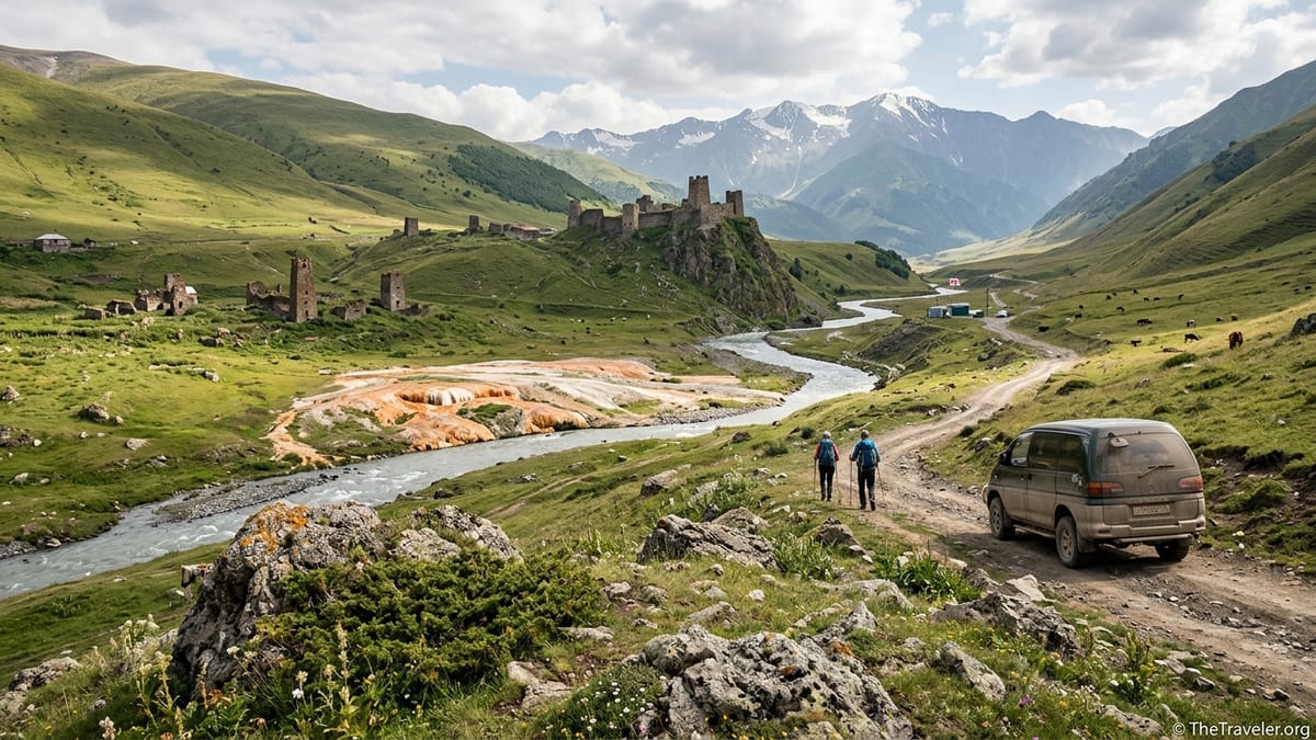
Understanding the Truso Valley Route from Kazbegi
Truso Valley lies west of the village of Kobi on the Georgian Military Highway, roughly 20 to 25 kilometers by road from Stepantsminda (Kazbegi). The walk itself follows a mostly unpaved vehicle track that climbs gradually along the upper Terek River through meadows, abandoned hamlets and travertine formations. Although the gradient is gentle, the combination of distance, altitude around 2000 to 2200 meters and lack of shade makes the full hike more demanding than many visitors anticipate.
Most recent route descriptions put the standard Kobi to Zakagori Fortress return at around 20 to 22 kilometers with roughly 250 to 350 meters of total ascent, depending on the exact drop‑off point in the valley. Several Georgian hiking resources and recent trip reports describe similar figures, while the official Kazbegi Protected Areas leaflet lists a longer variant of up to about 25 kilometers that continues further west beyond the usual tourist turnaround. This article focuses on the common route to the fortress and back, which fits most hikers into a full but manageable day.
Despite marketing that calls Truso an “easy valley walk,” you should think of this as a long, mostly exposed high‑altitude track rather than a short stroll. Many people underestimate the return distance, particularly if their driver drops them near the Kobi junction and they end up adding several kilometers of road walking in and out. For a safe and enjoyable trip from Stepantsminda, it is wise to treat Truso as a full‑day excursion that requires early start times, realistic turnaround points and attention to changing weather.
Getting to the Trailhead: Kobi and the Rough Valley Road
The usual access to Truso Valley begins near Kobi village on the Georgian Military Highway. Stepantsminda to Kobi is around 20 kilometers by paved road and is easily reached by private car or taxi. The complication starts where a narrow dirt road branches south and then west into the valley. Local drivers and recent visitors consistently describe this track as rough, rutted and sometimes muddy, with shallow river crossings and sections that can deteriorate quickly after rain.
Ordinary city taxis and low‑clearance rental cars can usually reach the first parking area near a small cluster of houses and a bridge over the Terek, especially in dry summer conditions. From Stepantsminda, recent traveler reports in 2026 mention paying around 80 to 120 GEL return for a standard taxi to this first parking area, usually with an agreed pickup time in the afternoon. However, several drivers are cautious about continuing farther into the valley with a regular sedan, particularly in May, June and after heavy storms, when ruts, rocks and standing water are more pronounced.
To travel deeper along the valley road by vehicle you generally need a 4x4 with high clearance, most commonly a Mitsubishi Delica style van. Local drivers based in Stepantsminda offer dedicated Truso Valley trips, charging approximately 250 to 400 GEL per vehicle for a full 4x4 excursion that can go close to Zakagori Fortress in good conditions, often combining photo stops and short walks. For budget travelers, sharing a taxi or Delica between four or more people can bring the per‑person price down to around 40 to 80 GEL for straightforward round‑trip transfers, provided you negotiate clearly before departure.
Scheduled shared shuttles from Stepantsminda once ran daily in high season, but services have changed in the last couple of years. Some agencies have suspended regular buses or require a minimum number of passengers, making it unreliable to count on walk‑up seats. As of autumn 2026, travelers report that arranging transport on the main square in Stepantsminda on the morning of the hike is still practical, but you should confirm prices, route (to first parking or deeper), and pickup times in person rather than relying on older online information.
Route Breakdown: Key Stops, Distances and Turnaround Options
Most hikers start their walk from the main parking area near the first bridge inside the valley, a short drive past Kobi. From here to Zakagori Fortress and back is roughly 18 to 20 kilometers on a broad track, with only small undulations. If your driver prefers to stop closer to the highway or if you begin at Kobi village itself, you can easily add 2 to 4 kilometers to the total distance.
Within the first hour of walking, you pass colorful mineral springs and travertine terraces near Keterisi and the Truso Travertines Natural Monument. These bright orange and white formations lie at around 2090 meters above sea level and are one of the most striking features of the valley. The section from the parking area to the travertines is about 3 to 4 kilometers each way, making it a logical short outing for visitors who want scenery without committing to the full distance.
Continuing west, the track passes the Abano area, where hot mineral springs bubble from the ground near ruined stone houses, and then approaches the semi‑abandoned village of Ketrisi with its old tower houses and chapels. This middle section from the travertines through Abano to Ketrisi adds another 3 to 4 kilometers one way. A turnaround at Ketrisi or the nearby bridge creates a walk of roughly 12 to 14 kilometers return, suitable for moderately fit hikers who want a full half‑day experience without pushing all the way to the border zone.
Beyond Ketrisi the valley narrows slightly and the track climbs gently towards Zakagori Fortress, perched on a rocky spur overlooking the administrative boundary with the occupied Tskhinvali region (South Ossetia). From Ketrisi to the fortress is roughly 3 kilometers one way, with the last few hundred meters sometimes on a footpath rather than a vehicle track. Reaching the base of the fortress and the nearby border police post usually brings your total distance for the day close to the 20 to 22 kilometer mark if starting from the main parking area. Only very fit and well‑prepared walkers should attempt to add extra distance beyond these points.
Border‑Zone Rules and Safety Near Zakagori
The upper end of Truso Valley sits close to the administrative boundary line with the Russian‑occupied Tskhinvali region, part of the wider South Ossetia conflict area. Georgian law treats these territories as occupied and strictly regulates access. Entry into the occupied region itself is only legal through designated directions with special permits that serve state or humanitarian purposes. For tourists, crossing the boundary in Truso Valley is both illegal under Georgian law and risky due to the presence of Russian and de facto security forces on the other side.
Near Zakagori Fortress, Georgian border police maintain a visible presence and operate checkpoints or observation posts, managed under the Land Border Protection Department. Their role is to protect the border, enforce regulations and keep visitors away from the boundary line. As of late 2026, normal hikers who stay on the standard track to the fortress do not usually require advance permits, and foreign visitors can access the valley using their regular passports or ID documents. However, border officers may check identification near the end of the route and may instruct hikers to turn around at specific points depending on the current security situation.
It is important to understand that some older blog posts mention walking beyond Zakagori up the valley floor or attempting to approach abandoned settlements closer to the boundary line. Such behavior is no longer considered acceptable or safe. There have been documented cases in past years of tourists who wandered across the line in fog or curiosity and were detained by Russian border guards, then released only after paying fines. You should never try to cross any fence, ditch, sign or informal barrier beyond the Georgian positions, and you must respect any verbal instructions from border police on where to stop or turn back.
If you have any doubt about current rules, ask at your Stepantsminda guesthouse, a reputable local tour agency or directly at the Kazbegi tourist information point before your hike. For activities beyond the standard route, such as research work or documentary filming close to the boundary, you must coordinate in advance with the relevant Georgian authorities and obtain formal permits. This article does not encourage or describe any route that goes beyond the controlled hiking area near Zakagori.
Seasonal Conditions, Weather Hazards and Livestock
Although Truso Valley is accessible for much of the year, the practical hiking season for most visitors runs from roughly late May to early October. In April and early May, snow can linger on shaded slopes and higher sections of the valley, melting during the day and refreezing at night. This spring snowmelt feeds fast‑flowing side streams that cut across the track, turning shallow fords into knee‑deep channels and creating muddy sections where vehicles and hikers may struggle. Landslide and rockfall risk is also slightly higher in late spring when slopes are saturated.
From June to September, daytime temperatures in the valley can be comfortable but the sun is strong at 2000 meters and there is little natural shade. Afternoon thunderstorms are common, particularly in July and August, bringing sudden heavy rain, wind and temperature drops. Even a short storm can turn dry dust into slippery mud and swell small streams enough to make crossings unpleasant or temporarily unsafe. Visibility may also drop quickly, making it harder to judge where the border line lies near Zakagori and increasing the importance of turning around in time.
Another practical consideration is livestock and guardian dogs. Truso’s meadows are used as summer pasture for cattle and sometimes sheep. Large, protective sheepdogs are occasionally encountered near flocks. These dogs are working animals and can react aggressively to perceived threats. Hikers should give wide berth to herds, avoid walking directly through the middle of animals, keep trekking poles low, and avoid sudden movements toward lambs or calves. Local herders are usually nearby and may call the dogs away, but if a dog approaches, it is safer to stand still, avoid eye contact and speak calmly rather than run.
The valley has no shops, cafes or reliable sources of supplies once you leave Kobi, and mobile coverage can be intermittent or absent in the deeper sections. Several recent hikers note that messaging apps only reconnect once they return toward the main highway. You should therefore plan to be self‑sufficient for water, food, sun and rain protection, and basic first aid for the entire day.
Navigation, Equipment and Emergency Planning
The main Truso Valley route follows a clear unpaved vehicle track that is easy to follow in good weather. However, side tracks, animal paths and occasional snow patches early or late in the season can cause confusion, especially in poor visibility. Carrying an offline map on a smartphone app and a power bank is highly recommended. Common tools that work well in Georgia include dedicated hiking apps and satellite‑based maps that show the track as a valley road between Kobi and Zakagori.
At a minimum, day hikers should bring sturdy walking shoes or light boots with good grip, a waterproof jacket, warm layer, sun hat, sunglasses and high‑SPF sunscreen. Trekking poles are helpful on muddy sections and stream crossings. Because water quality from local springs can be uncertain, especially near grazing areas, carrying at least 1.5 to 2 liters per person and a lightweight filter or purification tablets is wise. Many visitors underestimate how much they will drink on an exposed high‑valley track, particularly on sunny July or August days.
Emergency procedures in Truso require more self‑reliance than a town‑side hike. There is no on‑site rescue station. In case of injury or sudden illness, the realistic options are to contact Georgian emergency services by phone where coverage exists, to send one member of the group back toward Kobi to call for help, or to flag down one of the 4x4 tour vehicles that regularly drive the valley in high season. For solo travelers, the risk calculus is different. If you hike alone, inform your guesthouse of your plan, expected turnaround time and latest return, and consider sticking to the shorter options such as the travertines and Ketrisi rather than pushing to Zakagori.
Language is another consideration. Many drivers and herders in the area speak limited English or other foreign languages. Learning a few simple Georgian phrases related to directions, timing and prices can smooth communication and help in minor difficulties, but serious emergencies still require a clear plan to reach police or medical services in Stepantsminda.
Costs, Transport Choices and a Realistic Day Itinerary
For a couple staying in Stepantsminda, a realistic independent Truso day might include a round‑trip taxi to the main valley parking, snacks and water bought the day before, and a simple guesthouse room. Recent examples from autumn 2026 suggest that a negotiated taxi price of about 100 to 150 GEL return for the car is common, which comes to roughly 50 to 75 GEL per person for two people if the ride includes waiting time and a pickup agreed at a fixed hour.
For small groups of three to six, hiring a 4x4 Delica with driver for a deeper valley drop‑off can cost around 250 to 400 GEL for the vehicle, depending on season and bargaining. Split between four people, that comes to approximately 60 to 100 GEL per person, including a flexible pickup arrangement. Guided 4x4 tours sold through agencies in Tbilisi or Stepantsminda can be more expensive, but they often include commentary, photo stops and sometimes a simple picnic, pushing the per‑person cost well above 150 GEL in peak season.
A sample full‑day independent itinerary from Stepantsminda might look like this. At 07:30, have breakfast and double‑check the weather forecast. By 08:00, negotiate a taxi or 4x4 in the town center and depart. Reaching the Kobi junction takes about 30 minutes, with another 10 to 20 minutes along the dirt road to the main valley parking, depending on conditions. Starting the hike by 09:00 gives you long daylight margins. Allow around 2 hours to reach Ketrisi with short photo breaks, then another 45 to 60 minutes to reach the area below Zakagori Fortress. After a rest, snacks and exploration within the limits set by border police, you can begin the return around 13:30 or 14:00 and be back at the parking area by 17:00 at a moderate pace.
This schedule builds in time for slower walkers and weather delays, as well as a safety buffer if you want to wait for your driver or flag down another vehicle. In Stepantsminda you can be back at your guesthouse by around 18:00 or 18:30. If afternoon storms are forecast or if you are hiking in September and daylight is shorter, consider an earlier start or a planned turnaround at Ketrisi to ensure you return to the road before dark. Couples on a mid‑range budget might expect to spend roughly 250 to 350 GEL in total for the day, including transport, picnic food, and basic guesthouse accommodation, while groups sharing a vehicle can reduce their per‑person costs significantly.
Lower‑Effort Alternatives and Who Should Attempt the Full Hike
Not every visitor to Kazbegi needs to attempt the full Truso Valley return to Zakagori. A popular lower‑effort option is to ask a driver to take you to the main valley parking and then walk only as far as the travertine terraces and mineral springs, spending time exploring the formations and nearby chapels before returning the same way. This creates a scenic 6 to 8 kilometer outing with minimal ascent, comfortable for families with older children, casual walkers and those coming from sea level who are still adjusting to altitude.
Another gentler choice is to walk from the parking area through Keterisi and the Abano section, then turn back before the last stretch to the border zone. At around 12 to 14 kilometers total, this variation provides a strong sense of Truso’s wide valley landscape, ruined towers and mineral springs without committing you to the full distance or the last border‑policed segment. Some 4x4 tours also offer the option of driving deeper into the valley and dropping passengers for a mostly downhill or flat walk back toward Ketrisi, reducing physical effort while still spending several hours on foot.
The full hike to Zakagori and back suits hikers with solid fitness, experience walking 18 to 22 kilometers in a day, and comfort with remote, exposed terrain. It is a better choice for people who already completed another local hike, such as the Gergeti Trinity to glacier viewpoint or the Gveleti waterfalls, and found those distances manageable. Those with heart or respiratory issues, very limited hiking experience, or strong anxiety about border zones will likely enjoy a shorter Truso excursion more.
In all cases, the key to enjoying Truso Valley is honest self‑assessment. The landscape is striking from almost the first kilometer, so there is no need to push on purely to “collect” Zakagori if fatigue, approaching storms or nervousness about the border make you uneasy. Turning around at the travertines, Abano or Ketrisi still delivers a memorable day in one of Georgia’s most atmospheric high valleys.