
More news on this day
New York is bracing for what forecasts describe as its most significant snowfall in two years, with a developing winter storm expected to snarl air travel across the Northeast and trigger widespread flight delays and cancellations at some of the nation’s busiest airports.
Get the latest news straight to your inbox!
Storm Setup Points to Major Snow for New York
Forecast discussions from the National Weather Service and regional meteorologists indicate that a strong coastal low is expected to track up the Eastern Seaboard, drawing in Atlantic moisture over a dome of entrenched cold air. That combination is projected to produce a broad swath of heavy, wet snow from the Mid-Atlantic into New England, with New York City, its northern suburbs and parts of upstate New York in line for some of the highest totals.
Early outlooks describe this system as the largest snow event to affect much of New York state since the high-impact winter storms of early 2024, with some local coverage labeling it the biggest snow in at least two years for portions of the Capital Region and downstate corridors. Snowfall projections remain subject to change, but several forecast models are signaling the potential for more than 8 to 12 inches in parts of the New York City metro area and inland locations if the storm’s track remains close to the coast.
The broader Northeast corridor from Philadelphia to Boston is also expected to see substantial accumulation. Publicly available outlooks for the region highlight the potential for a classic nor’easter setup, including strengthening low pressure offshore and tightening pressure gradients that could enhance snowfall rates at the height of the storm.
Timing: When the Heaviest Snow Is Expected
Based on current guidance, snow is projected to overspread the New York City area and much of downstate New York from the south and west, arriving as light precipitation before intensifying during the core of the event. Forecasters suggest that the most disruptive period is likely to coincide with high travel times, particularly from Sunday evening into Monday, when the heaviest banding of snow could set up along the Interstate 95 corridor.
In interior sections of New York and across higher elevations, temperatures are expected to remain cold enough for predominantly snow throughout the storm, increasing the likelihood of deeper totals. Closer to the immediate coast and eastern Long Island, a brief mix with sleet or rain cannot be ruled out, which could slightly limit accumulations but increase the risk of slick, icy surfaces.
Travel conditions on roadways are expected to deteriorate quickly once snowfall rates increase. Past storms of similar structure have produced snowfall rates of 1 to 2 inches per hour at times, rapidly covering treated surfaces and making it difficult for plows to keep pace. Motorists planning trips during the storm window are being advised by public forecasts and municipal advisories to monitor updates closely and adjust plans where possible.
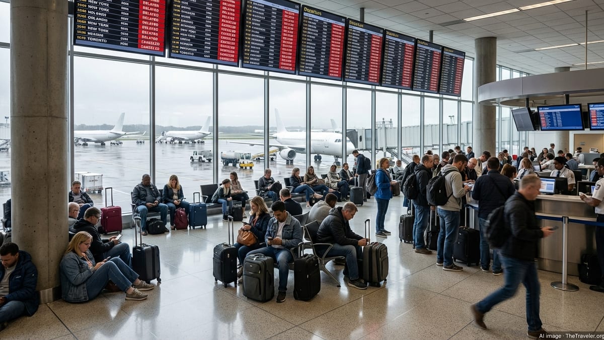
Air Travel Disruptions Across the Northeast
The looming snow event arrives in the wake of a winter season that has already produced several high-impact storms, including a late January system that led to some of the highest flight cancellation totals since the pandemic era, according to travel and aviation reports. That storm brought heavy snow to New York’s LaGuardia and John F. Kennedy airports and contributed to thousands of cancellations as airlines struggled with runway conditions and aircraft de-icing.
With the new system expected to again target the densely traveled Northeast corridor, major hubs including New York, Newark, Boston and Philadelphia are preparing for another round of significant disruption. Data from previous storms this winter show that large-scale events can quickly cascade into nationwide impacts, as grounded aircraft and crew misalignment ripple through airline networks for several days after the last flakes fall.
Flight tracking services and aviation industry coverage indicate that carriers have increasingly moved toward proactive schedule reductions in advance of major winter storms, trimming flights before conditions deteriorate in order to limit day-of chaos. Travelers booked through the Northeast over the coming days are being urged in public advisories and airline notices to check their flight status frequently and to watch for the issuance of flexible rebooking waivers.
What Travelers Should Expect and How to Prepare
For passengers flying into or out of New York and other Northeast gateways, the most immediate impact is likely to be extended delays, followed by waves of cancellations if snowfall rates and visibility drop below operational thresholds. Even airports less directly affected by heavy snow may experience knock-on effects as aircraft that were scheduled to arrive from New York, Boston or Philadelphia fail to reach their next destinations on time.
Published guidance from travel experts and consumer advocates emphasizes several key steps for those with upcoming trips. These include signing up for airline text or app alerts, traveling with carry-on baggage when possible to retain flexibility if flights are retimed, and considering voluntary rebooking to earlier or later flights outside the storm’s peak window if airlines allow changes without additional fees.
Rail and road options may provide alternatives for some travelers, but those modes are also subject to disruption. During previous Northeast winter storms this season, Amtrak and regional rail operators reduced schedules or imposed speed restrictions, while state and local transportation departments reported hazardous driving conditions and, in some cases, temporary travel advisories or restrictions on major highways.
Regional Impacts Beyond the Airports
Beyond the aviation sector, the storm’s expected snowfall and strong, gusty winds could affect daily life across a wide swath of the Northeast. Recent nor’easters have produced scattered power outages, localized coastal flooding and the closure of schools and government offices from New Jersey to New England, and a similar pattern is possible if this system intensifies as projected.
Energy and infrastructure assessments from previous events this winter note that heavy, wet snow tends to pose a greater threat to power lines and tree limbs than powdery, low-moisture snow, increasing the potential for service interruptions even when total accumulation is moderate. With forecasts hinting at a marginal temperature profile near the coast, utilities in New York and neighboring states are likely to watch for signs of heavier, denser snow bands developing.
For residents and visitors alike, publicly available emergency preparedness materials recommend stocking basic supplies, allowing extra time for commutes, and taking advantage of remote work or learning options where available. As with earlier storms this season, the ultimate severity of the event will depend on the exact track of the low and the position of the sharpest snow bands, which may shift east or west as updated model runs are released.