
More news on this day
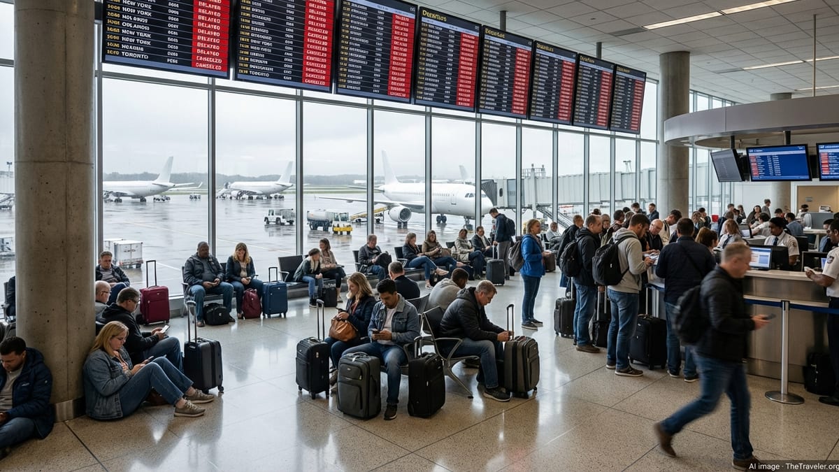
Severe thunderstorms over Central Florida are disrupting operations at Orlando International Airport on June 20, with some departures temporarily grounded and airlines warning of significant knock-on delays across busy afternoon and evening travel periods.
Get the latest news straight to your inbox!
Stormy Skies Create Sudden Capacity Crunch
Weather radar and aviation tracking platforms show strong storm cells building over the Orlando area, bringing heavy rain, lightning and low cloud ceilings that reduce the number of aircraft air traffic controllers can safely move in and out of the region at once. When conditions deteriorate quickly, flight volumes must be cut back, triggering delays that ripple throughout the schedule.
Publicly available flight tracking data indicates that aircraft arriving into Orlando have been placed in extended holding patterns or redirected to alternate airports when storm cells move directly over the field. At the same time, departures already on the taxiways face longer queues or brief returns to the gate when lightning activity intensifies or visibility drops below set thresholds.
Operational planners describe this as a sudden capacity crunch, where Orlando’s normally high throughput is sharply constrained by weather. Even short ground stops lasting 30 to 60 minutes can leave dozens of flights out of position, affecting later departures from Orlando and connecting flights downline at other hubs.
The timing of the storms further complicates the picture. Afternoon and early evening are among the busiest periods for both leisure and connecting traffic at Orlando International Airport, so any weather-related slowdown during these hours tends to have outsized effects on the traveling public.
Ground Stops, Diversions and Rolling Delays
According to published coverage of current aviation conditions, Orlando is experiencing a mix of departure holds, rolling ground stops and sporadic diversions as storm cells pulse across Central Florida. Ground stops temporarily halt takeoffs or arrivals for safety, while traffic management programs meter departures more slowly than usual, often assigning specific controlled departure times to each flight.
Travelers in the terminal are seeing these measures play out as successions of short but repeated delays, with departure times pushed back in increments as airlines and controllers wait for safe weather windows. In some cases, aircraft that left the gate on schedule have remained on taxiways for extended periods before returning to gates when lightning re-intensified over the airfield.
Reports from aviation tracking communities indicate that several inbound flights have diverted to nearby airports when thunderstorms parked over Orlando for longer than forecast. These diversions keep passengers and crews safe but create further schedule challenges, as aircraft must refuel and reposition before reentering the Orlando system once weather improves.
The result is a fragmented operational picture in which some flights are able to depart close to schedule between storm bands, while others experience lengthy waits. Passengers are encouraged to treat all departure times as subject to change throughout the day.
Broader Weather Pattern Strains Florida Air Travel
Meteorological analysis over recent days points to an unsettled pattern across the Southeast, with deep tropical moisture, high instability and daily rounds of strong to severe thunderstorms. Forecast discussions highlight the risk of intense downpours, frequent lightning and gusty winds around Central Florida, conditions that routinely slow or temporarily halt air traffic.
Weather outlets tracking the broader national picture describe a highly active pattern, with multiple regions facing severe weather hazards and heat. For Florida, that has meant not only lightning and heavy rain but also reduced visibility at times due to humidity and, in other parts of the state, wildfire smoke. These overlapping hazards add complexity for airlines, which must plan around both convective storms and lower-level visibility restrictions.
Published accounts of recent operations across the Southeast show that Orlando is not alone. Other major hubs have also reported thunderstorm-driven ground delays in recent days, illustrating how fast-building summer storms can disrupt even well-prepared airline schedules. When these events coincide with peak travel periods, they tend to produce full gate areas, crowded concourses and stressed passenger flows.
In this context, the disruptions at Orlando International Airport fit into a wider pattern of weather-related challenges that airlines and airports across the region have been working to manage through tactical schedule adjustments, reroutes and revised crew planning.
What Travelers Flying Through Orlando Should Expect
For passengers headed to or from Orlando today, publicly available information suggests a high likelihood of schedule changes, even for flights that ultimately operate. Travelers should prepare for extended time at the airport, possible gate changes and longer boarding windows as airlines adjust operations in real time to match breaks in the storm activity.
Airlines are updating flight status tools, mobile apps and push notifications as new departure slots are assigned and weather bands evolve. These digital channels often receive schedule changes before they are displayed on terminal boards, so keeping devices charged and notifications enabled can provide the earliest insight into revised timings.
Given the possibility of diversions or prolonged ground holds, passengers with tight connections at other airports are particularly vulnerable to missed onward flights. Industry guidance typically recommends building extra buffer into itineraries during periods of active thunderstorms, especially in summer, when localized storms are both frequent and intense.
Travelers who have not yet departed for the airport may wish to check their flight status multiple times and allow additional travel time, as storm-related traffic and heavy rain can also slow road access to the terminals. For those already in the terminal, staying close to the gate area and monitoring announcements can help reduce the risk of missing newly assigned boarding windows when weather briefly improves.
Operational Outlook for the Rest of the Day
Short-range forecasts indicate that thunderstorms around Orlando are likely to remain a factor through the late afternoon and evening, though intensity may fluctuate. Experience from similar patterns suggests that operations may recover somewhat between storm pulses, only to slow again when new cells form over or near the airport.
Aviation planning resources point out that the lingering effects of today’s disruptions could stretch into late-night and early-morning operations, as airlines work through aircraft and crew imbalances. Overnight recovery flights, repositioning operations and modified morning schedules are common tools carriers use to restore normal patterns after a day of significant weather.
For Orlando, where passenger volumes are driven heavily by leisure travel and theme park visitors, this means some travelers may arrive later than planned, while others could see their departures shifted into late-night windows. Hotel stays, rental car pickups and ground transport may need to be adjusted at short notice.
While conditions will ultimately improve as the storm system weakens or moves away, the combination of severe weather, high seasonal demand and tightly scheduled aircraft rotations means that Orlando International Airport is likely to experience residual delays even after the most intense storms have passed.