


Suva Planina rises sharply above Niš and Niška Banja, offering everything from gentle forest walks to one of the most demanding marked ridge traverses in southern Serbia. The different starting points, variable trail conditions and exposed limestone terrain mean that a casual visitor who simply “heads for Trem” can easily underestimate the mountain. This guide unpacks how Suva Planina is structured, how to reach its main trailheads, which routes are realistic for beginners, and why the complete Suva Trail circuit is officially graded very difficult rather than a normal scenic day hike.
Get the latest updates straight to your inbox!
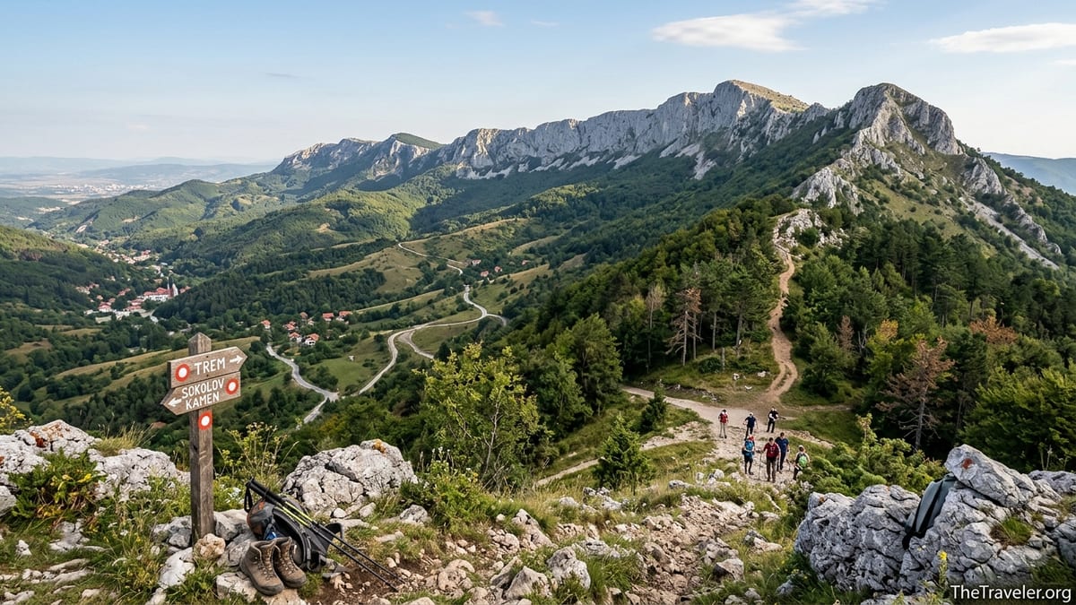
Understanding Suva Planina’s Geography and Access from Niš
Niš is the main urban base for Suva Planina. The city lies roughly 20 to 25 kilometers northwest of the mountain ridge, connected by regional roads to the spa town of Niška Banja and to villages such as Gornja Studena and Donji Dušnik that sit closer to the high slopes. The limestone wall of Suva Planina runs roughly east to west, with Trem at 1,810 meters and Sokolov Kamen at about 1,523 meters among its highest points. From the center of Niš, you typically need 30 to 45 minutes by car to reach practical trailheads on the northern side of the massif.
Niška Banja, a small spa settlement about 10 kilometers southeast of Niš, is often the first place visiting hikers hear about. Local city buses run regularly between Niš and Niška Banja, which can give the impression that the spa is the natural gateway to every route on Suva Planina. In practice, the classic approach roads to Bojanine Vode and to the high trailheads above Gornja Studena or Donji Dušnik branch off several kilometers beyond the town, where public transport is limited or absent. This gap matters for planning because walking long asphalt sections up steep valley roads at the start or end of a mountain day can add two or more hours to an already serious hike.
Bojanine Vode, at around 860 meters on the northern slopes, is a key launch point for the Trem and Sokolov Kamen routes. It is reached along a mountain road that starts near Gornja Studena and climbs through the forest. There is a mountain lodge and car parking at Bojanine Vode, but no scheduled bus service. Hikers without a vehicle usually rely on taxi transfers from Niš or Niška Banja, or they join an organized mountaineering club trip that provides group transport.
The village of Koritnik lies on the lower slopes above Niška Banja and connects via paths to the ridge around Crni Kamen and Devojački Grob. Local paths from Niška Banja to Koritnik, and onward toward Crni Kamen, do exist and are used for training and shorter outings. However, they are significantly longer and lower than the higher trailheads at Bojanine Vode or Gornji Dušnik, and they do not provide an easy shortcut to the most popular summit line from Bojanine Vode to Trem.
The Official Suva Trail Circuit and Why It Is Classified as Very Difficult
The Serbian Mountaineering Association maintains an official database of marked routes, including a demanding circuit called the Suva Trail. This route begins in the center of Niška Banja at about 258 meters and follows the “health path” toward Koritnik before climbing to the ridge of Suva Planina. From there it continues along the crest over Sokolov Kamen, Devojački Grob and onward to Trem, before looping back to Niška Banja. The full circuit is recorded at around 43.5 kilometers in length with cumulative ascent and descent of roughly 2,400 meters in each direction according to the Association’s listing.
In the official grading system this Suva Trail circuit is explicitly marked as very difficult. That rating reflects not only the distance but also the combination of steep forest climbs, long high-altitude sections on exposed limestone and the commitment required once you are far from any road. On a dry spring or autumn day, fast local trail runners might complete the circuit, but most normal hikers would require far more than a comfortable day and would face serious fatigue and navigation risk after dark.
Because of this, the full Suva Trail should not be marketed as a normal beginner hike or an easy “spa-to-summit” outing for guests staying in Niška Banja. It is closer in character to an alpine ultramarathon route than to a family footpath. Even experienced hikers who are new to Suva Planina usually break their visit into shorter day hikes based from Bojanine Vode, Niška Banja or nearby villages rather than attempting the entire circuit in one push.
Shorter official routes also exist in the same database, including variants that start at higher points like Bojanine Vode and connect either to Trem or to intermediate viewpoints. These routes share some segments with the Suva Trail but involve much less distance and ascent. Understanding which segments you intend to follow, and how they relate to the demanding 43.5 kilometer circuit, is essential before you start walking.
Comparing Key Day Hikes: Koritnik, Crni Kamen, Bojanine Vode, Sokolov Kamen and Trem
For visitors who want a manageable introduction to Suva Planina, the lower slopes above Niška Banja and Koritnik offer shorter options. Paths from Niška Banja climb through mixed forest and orchards toward the village, gaining several hundred meters and leading to viewpoints around Crni Kamen. These routes are often chosen by local walkers because they can be reached using city buses and require no special logistics. Typical out and back distances range roughly from 8 to 15 kilometers with total ascent of 400 to 700 meters, well within the capabilities of moderately fit beginners.
The classic mountain day for fit hikers remains the route from Bojanine Vode to Trem. Mountaineering clubs describe this as approximately 15 kilometers total, generally planned as an out and back via Devojački Grob, which sits near a key junction on the ridge. Elevation gain from Bojanine Vode to Trem is in the range of 900 to 1,000 meters. Most organized groups allow around 6 to 8 hours for the return trip depending on fitness and weather, including breaks at Devojački Grob and on the summit.
A demanding variant follows a ridge loop from Bojanine Vode over Mosor and Sokolov Kamen to Devojački Grob and then Trem. This line is spectacular but considerably more strenuous and time consuming because it stays on the exposed crest for long stretches. The exposed limestone blocks, rocky steps and occasional narrow sections require good balance and confidence with heights. Even local hikers advise that this route is not suitable as a first mountain walk and that beginners who want to reach Trem should take the more direct forested path via Devojački Grob and return the same way.
Approaches from the south, such as from Donji Dušnik over Pasarelo or from the Bela Palanka side, add further options but usually involve longer driving times and even fewer public transport choices. Reports from hikers who have used these southern routes emphasize that the trails are well marked but that they lack water and are very exposed once out of the forest. For most visitors staying in Niš or Niška Banja, the northern access via Bojanine Vode or the lower paths above the spa town remain the most practical choices.
Trail Markings, Water Sources and Seasonal Hazards
Suva Planina’s main hiking lines are generally well marked with standard red and white circles on trees and rocks. Hikers consistently report that the path from Bojanine Vode to Devojački Grob, and onward to Trem, is easy to follow in clear weather. Markings are also strong on the ridge sections used by the Suva Trail, including toward Sokolov Kamen. However, the open limestone terrain can be confusing in fog or snow, when markers on rocks may be hidden. In such conditions, navigation skills and a GPS track are very important.
Reliable drinking water is a critical issue on Suva Planina. Bojanine Vode itself is known for springs and gives the area its name. There is a mountain lodge at Bojanine Vode with water sources, and hikers mention at least two drinkable springs near the lodge and below the slopes of Sokolov Kamen. Another recorded spring lies at Koritnik, closer to the lower routes above Niška Banja. Outside these points, the high ridge is largely dry, which is consistent with the mountain’s name meaning Dry Mountain. Hikers should carry several liters of water per person for any outing that goes above the tree line and confirm locally whether the springs are flowing in late summer.
Climate and terrain hazards on Suva Planina are significant. The bare limestone amplifies summer heat, particularly on the ridge between Sokolov Kamen and Trem, where there is almost no shade. In strong sun, there is a real risk of dehydration and heat stress, so early starts, wide brimmed hats and high factor sunscreen are essential in July and August. In autumn and winter, cold winds funnel over the ridge and can make conditions feel far colder than the temperature suggests. Hikers who have climbed Trem in winter report being hit by strong winds as soon as they leave the forest, making warm layers and windproof shell jackets vital.
Fog is another recurrent hazard. Because Suva Planina rises steeply from the plains around Niš, cloud often forms quickly along the crest. In thick fog, the open karst above Devojački Grob can feel featureless and disorienting. Losing the marked route in such conditions is not difficult, which is one reason why the Mountaineering Association and the Serbian Mountain Rescue Service regularly stress the need for proper planning, maps and the willingness to turn back if visibility collapses.
Transport, Road Conditions, Costs and Facilities on the Mountain
From Niš, regular city buses connect the center with Niška Banja, which functions as a public transport gateway. Tickets for city buses are inexpensive, typically under a few hundred dinars for a one way ride. From Niška Banja to Koritnik, most hikers walk or arrange private transport, since there is no frequent scheduled service up the mountain roads. The road itself is narrow and climbs steeply through villages, but local walkers use it as a practical link to the network of footpaths.
Reaching Bojanine Vode is more complex without a car. The access road branches from the direction of Gornja Studena and climbs through forest to the mountain lodge and former ski area. Local hikers describe the road as paved or partially paved but with potholes and rough sections. Most standard cars use it carefully in good weather, although snow and ice in winter can make it problematic. There is informal parking near the lodge and around the end of the road. Taxi rides from central Niš to Bojanine Vode are often arranged through local companies, with recent anecdotal reports suggesting one way prices on the order of a few thousand dinars, varying with fuel costs and negotiation. It is advisable to confirm the fare and a return time in advance.
Facilities on the mountain itself are limited. The mountain lodge at Bojanine Vode, sometimes referred to as Planinarski dom Studenac, offers simple dorm style beds and basic meals when it is open for groups or organized events. Availability fluctuates by season and by arrangement with mountaineering clubs, so independent hikers should contact local organizations in Niš ahead of time if they hope to stay overnight. There are no staffed huts on the high ridge between Sokolov Kamen and Trem, and no commercial cafés or restaurants on the trails. Hikers must be completely self sufficient in food and water once they leave the valley.
For supplies, Niš has large supermarkets and outdoor shops where visitors can buy snacks, gas canisters and basic gear such as trekking poles and rain jackets. Niška Banja offers small grocery stores and bakery options suitable for picking up fresh bread and pastries early in the morning. Many hikers combine a pre dawn bakery stop in Niš with a taxi ride to Bojanine Vode or Gornja Studena, ensuring they start walking with enough calories for a full day on the mountain.
Safety, Rescue, Seasonal Advice and Equipment
The Serbian Mountain Rescue Service, known as Gorska služba spasavanja, operates across the country and works closely with the Mountaineering Association. Public information from recent interviews and safety campaigns emphasizes that they receive hundreds of calls each year, many from hikers who underestimated conditions or overestimated their abilities. The rescue service highlights the importance of preparing a simple communication plan, informing someone of your intended route and estimated return time, and carrying a fully charged phone plus a spare power bank.
The widely publicized emergency number for the Mountain Rescue Service is a mobile line that begins with 062 followed by 464646. Hikers can also dial the general European emergency number 112, which will connect to the national system and, if necessary, to mountain rescue teams. In southern Serbia, including the Suva Planina area, there is a core of trained rescuers who cooperate with the Ministry of Interior’s emergency units. Mobile coverage is generally present on exposed parts of the ridge but can be weak or intermittent in some forested gullies, so it is unwise to rely solely on data based navigation without offline maps.
Rescue experts and mountaineering clubs repeatedly recommend that even for non winter hikes on Suva Planina, visitors wear proper hiking boots with a good grip, carry weatherproof clothing including a windproof layer, bring headlamps with spare batteries, and pack at least a basic first aid kit. In winter, Trem is considered a serious objective requiring crampons, an ice axe and experience with movement on snow and ice. Local clubs organize large winter ascent events, but they do so with strict equipment lists and experienced leaders, underscoring that this is not a casual snow walk.
Apart from equipment, realistic timing is part of safety. Clubs typically schedule Bojanine Vode to Trem and back within 8 to 9 hours, starting early in the morning to avoid finishing after dark. Hikers are advised to turn around time based rather than summit based, for example deciding to head back after a set number of hours if progress is slow or the weather is worsening. This mindset is particularly important for independent travelers who do not have local guides to enforce conservative decisions.
Sample Itineraries, Weather Alternatives and Budgeting
A practical half day introductory hike for visitors staying in Niš or Niška Banja is a loop or out and back from Niška Banja toward Koritnik and the lower viewpoints. For example, taking an early city bus to Niška Banja, walking through the spa park and following marked paths toward Koritnik can produce a 10 to 12 kilometer outing with 400 to 500 meters of ascent and several viewpoints back toward Niš. With breaks, this can be completed in 4 to 5 hours and allows time to enjoy spa facilities or cafés afterward.
A full day summit itinerary for fit hikers with some mountain experience could be the Bojanine Vode to Trem out and back. Starting from Niš before sunrise, a taxi or pre arranged transfer reaches Bojanine Vode by around 7 or 8 in the morning. From there, the marked trail climbs through forest to Devojački Grob, where hikers can rest and assess conditions on the ridge. If weather and energy levels are good, they continue along the crest to Trem, enjoy the panoramic views that stretch south to Šar Planina and north to Rtanj on clear days, and then return the same way to Bojanine Vode. This plan necessitates carrying food for the entire day and at least 2 to 3 liters of water per person.
In bad weather, or for days when legs need a rest, Niška Banja itself offers a viable alternative. The spa town has thermal baths, wellness centers in several hotels, forested health paths above the settlement and easy access to Niš by bus for cultural visits to the fortress, old bazaars and museums. A rainy day plan might include a morning walk on the lower paths above Niška Banja, followed by a thermal bath session and dinner in one of the local restaurants serving grilled meat, river fish or traditional dishes such as prebranac beans.
Travel and food budgets in Serbia remain relatively moderate compared with many European destinations, although prices have risen in recent years. As a planning reference, a simple meal in a local restaurant in Niš or Niška Banja often costs on the order of 800 to 1,500 dinars, while a coffee and pastry in a bakery might total 200 to 400 dinars. Taxi rides from Niš center to Niška Banja are usually priced roughly in the low thousands of dinars round trip, with trips to Bojanine Vode higher due to distance and rougher roads. Accommodation spans hostels and guesthouses starting from the low thousands of dinars per night per person to mid range hotels charging several thousand dinars for a double room. Exact figures change with inflation and season, so visitors should confirm current prices shortly before traveling.
Where to Stay and Who Suva Planina Is Really For
Accommodation choices strongly influence how you hike Suva Planina. Staying in Niš gives access to the widest range of options from budget hostels to business hotels, plus good food and nightlife. It also simplifies arrival and departure because Niš Bus Station and Niš Constantine the Great Airport sit close to the city. From central Niš, day trips to Suva Planina are easy to organize with early taxi departures and evening returns.
Niška Banja offers a quieter base oriented toward wellness and relaxation. Several spa hotels and private rooms cluster around the thermal complex, and staying here reduces commuting time to lower trailheads around Koritnik while still keeping Niš within easy bus reach. This can work well for travelers who want to combine gentle walking, spa time and perhaps one more serious guided hike to Trem.
On or close to the mountain itself, options narrow to mountain lodges and a handful of rural guesthouses in villages like Gornja Studena or Paljina. The lodge at Bojanine Vode is the classic choice for hikers who want to wake up already high on the slopes, but it often requires advance coordination with local mountaineering clubs regarding opening dates and capacity. Nearby rural campsites and farm stays provide an alternative for those traveling by car or bicycle who prefer to stay closer to nature.
Taking all of this together, it is important to reach a realistic verdict on Trem. The highest summit of Suva Planina is not technically alpine climbing, but it is a serious mountain objective. For travelers without a car or previous mountain experience, attempting Trem independently, especially via routes that include long ridge sections or parts of the full Suva Trail circuit, is not advisable. A more responsible approach is to start with lower hikes around Niška Banja and Koritnik, then, if the desire to climb Trem remains, join an organized trip with a Serbian mountaineering club or hire a licensed mountain guide who can manage transport, pacing and safety decisions. Suva Planina will still be there for a future visit, and enjoying it safely is far preferable to turning an ambitious hike into an avoidable rescue call.