
More news on this day
New Zealand’s lower South Island is bracing for hours of life‑threatening weather as a rare red heavy rain warning remains in place, with forecasters highlighting a dangerous combination of flooding, snow and severe gales across Otago, Southland and parts of the West Coast.
Get the latest news straight to your inbox!
Rare red warning focuses on coastal Otago and Clutha
MetService has issued a red heavy rain warning for coastal Dunedin and Clutha, signalling one of the highest levels of concern in New Zealand’s weather alert system. According to published coverage, the warning covers low‑lying coastal communities and hills inland, where intense bursts of rain are expected to fall on already saturated ground.
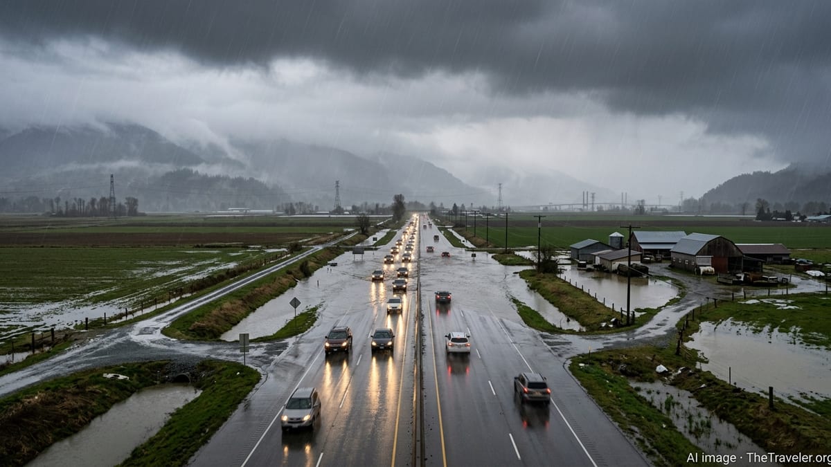
Forecasts indicate that the heaviest rain will continue through Sunday night into Monday morning, with accumulations high enough to trigger rapid rises on rivers and streams. The national forecaster’s guidance, cited in local media reports, points to a risk of surface flooding in urban areas such as South Dunedin, where drainage systems have struggled in previous events.
Regional emergency updates describe the red alert as signalling a threat to life from dangerous river conditions, significant flooding and slips. The Otago Civil Defence and Emergency Management Group notes that a strong, cold southeast flow is locking in over the lower South Island, helping to focus rain along the coast while colder air brings snow to inland districts.
Publicly available information from the Otago Regional Council shows that additional orange heavy rain warnings extend north into coastal North Otago, where totals are expected to be lower but still capable of causing local disruption. Communities between Ōamaru and Dunedin are being urged through public advisories to monitor local updates and be prepared for rapid changes in road and river conditions.
Flooding risk mounts as rivers rise and drains struggle
Reports from Dunedin and surrounding areas describe contractors clearing stormwater grates and checking known flood‑prone locations ahead of the worst of the deluge. Local coverage notes particular concern for South Dunedin, where much of the suburb sits barely above sea level and is highly sensitive to heavy rain and high groundwater.
Hydrology updates referenced by regional authorities indicate that catchments draining to Otago’s east coast are likely to respond quickly to the intense rainfall. Smaller rivers and streams may overtop stopbanks or inundate adjacent farmland well before larger mainstems reach peak flow, increasing the risk of rapidly changing conditions for rural roads and low‑lying properties.
Inland, on the slopes between Dunedin and Central Otago, heavy rain on steep terrain is expected to bring a heightened risk of slips. Previous South Island storms documented by national agencies have shown how saturated hillsides can suddenly collapse, cutting roads and isolating communities even where major rivers remain within their channels.
Council and civil defence messaging, as reported by New Zealand media, is emphasising that people should be prepared for potential self‑evacuation if they see rapidly rising water near homes or access routes. The guidance reflects lessons from earlier severe weather events in which roads were cut faster than formal evacuation orders could be issued or acted upon.
Heavy snow and hazardous highways across Otago and Southland
While coastal districts contend with flooding, much of inland Otago and Southland faces heavy snow. An orange heavy snow warning is in effect for northern Southland and inland Otago, excluding coastal strips, with forecasters pointing to snow levels lowering to around 200 metres in some areas as the cold southeast flow intensifies.
MetService outlooks, summarised by national broadcasters, indicate that snow may become heavy about higher passes and ranges through Sunday night and Monday. Road snowfall warnings cover several key alpine routes, raising the prospect of travel disruptions for freight movements and winter tourists.
New Zealand Transport Agency updates carried in local news bulletins anticipate possible closures or chain restrictions on South Island highways, especially where snow accumulates on shaded sections and strong winds create drifting. Even at lower elevations, slushy conditions and patches of black ice are expected to make driving hazardous.
Travel advisories urge motorists to avoid non‑essential journeys, carry chains where required and check the latest road information before setting out. Reports from recent storms across the island show that vehicles becoming stuck on snowy passes can quickly consume emergency resources and delay snow‑clearing operations.
Strong gales increase coastal and alpine dangers
Alongside flooding and snow, severe southeast gales are forecast for parts of Fiordland and the West Coast, adding another layer of risk. Guidance published by Otago civil defence planners describes the system as a strong, cold flow capable of producing damaging gusts in exposed locations and through gaps in the terrain.
In coastal Otago and Southland, squally winds combined with heavy rain are expected to bring down tree branches, damage unsecured structures and increase the likelihood of power outages. Power network operators, in statements reported by regional news outlets, typically warn that saturated soil makes trees more vulnerable to uprooting when gale‑force gusts arrive.
On alpine roads and high country tracks, strong crosswinds and low visibility from blowing snow are likely to create treacherous conditions. Previous events documented by transport agencies show that even experienced drivers can struggle to maintain control in such conditions, particularly when combined with ice and sudden gusts funnelled through saddles.
Marine forecasts indicate rough seas and dangerous conditions for small vessels along the southeast coast of the South Island. Boating and coastal safety organisations regularly advise that red and orange terrestrial weather alerts are often accompanied by rapidly deteriorating conditions offshore, with steep waves and confused seas near river mouths where floodwaters are surging out to sea.
Communities and visitors urged to prepare and stay informed
Local councils across Otago and Southland have been using public channels to remind residents and visitors to secure outdoor items, check emergency kits and keep mobile devices charged. Community notices highlighted by regional media recommend that people have plans in place for alternative accommodation, particularly in low‑lying or isolated areas.
Tourism operators are also monitoring the situation as ski fields and winter attractions straddle the boundary between beneficial snowfall and disruptive blizzards. Industry updates note that while fresh snow is welcome for the season, access roads and avalanche risk must be carefully managed during and immediately after severe weather events of this scale.
Publicly available information from national emergency management guidance stresses that red warnings are reserved for the most impactful weather situations, when immediate action is needed to protect people, animals and property. The ongoing alert for coastal Otago and Clutha fits within a broader pattern of more frequent high‑end warnings across New Zealand in recent years, as successive storms test community resilience.
Residents, travellers and businesses across the lower South Island are being encouraged in official advisories and media coverage to keep up to date with the latest forecasts and local updates over the coming 24 to 48 hours. With flooding, snow and gales expected to peak at different times and locations, the evolving situation may challenge even well‑prepared communities as this winter storm system continues to track across the region.