


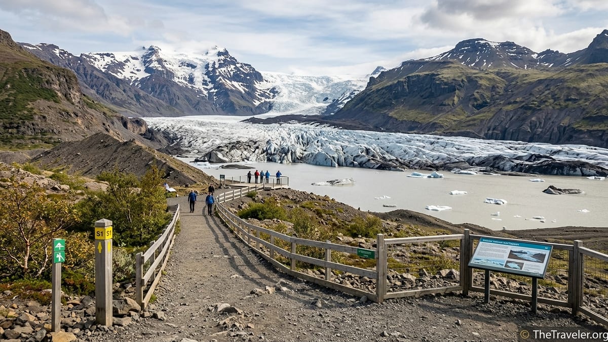
The Skaftafellsjökull Glacier Trail, marked S1 / Jökulslóð in Vatnajökull National Park, is the simplest way to walk from Skaftafell’s visitor area to a close, safe viewpoint over the Skaftafellsjökull glacier tongue and its proglacial lagoon. The national park currently lists this as an easy, waymarked loop of about 4.1 kilometres with roughly 80 metres of ascent, typically taking around 1 to 1.5 hours at a relaxed pace. It follows broad paths across glacial foreland to several fenced viewpoints, giving an accessible introduction to Iceland’s outlet glaciers without stepping onto the ice.
Get the latest updates straight to your inbox!
Trail facts and official classification
Vatnajökull National Park refers to this route as the Skaftafellsjökull Glacier Trail, Jökulslóð, trail S1. On the latest park maps and information boards at Skaftafellsstofa, it is shown as a circular walking route starting and finishing at the main Skaftafell visitor area. The signed distance at present is approximately 4.1 kilometres, with a modest elevation gain of about 80 metres spread along the loop, and the park classifies the trail in its easiest hiking category.
Waymarking uses the park’s standard colour system for easy day walks, with clear S1 symbols at junctions. The first section from Skaftafellsstofa is partly on a hardened or paved surface, before giving way to compacted gravel and moraine paths closer to the glacier. Directional posts and occasional small maps at junctions help you stay on the official route even in overcast weather, although low cloud can still limit distant views.
The park emphasises that S1 is a visitor trail to viewpoints only. It does not provide access onto the glacier surface, nor to the steep, unstable slopes and shoreline of the lagoon. Any travel on the glacier or down to the ice edge requires a booked tour with a certified glacier guide and specialist equipment, and current national park notices reinforce this separation between self guided walking and technical glacier activities.
Before setting out, it is sensible to confirm the latest distance, grade and any partial closures on the information boards inside Skaftafellsstofa or on the park’s current paper map. Minor changes to the routing or viewpoint positions are sometimes made in response to erosion, rockfall risk or the retreat of the glacier front.
Finding the trailhead at Skaftafell
The S1 trail begins next to Skaftafellsstofa, the main visitor centre at Skaftafell, which lies a short signed detour from Iceland’s Ring Road. From the central parking area, follow signs toward the visitor centre building. Toilets, water points and an information desk are located here, along with detailed maps of the local trail network.
To reach S1 specifically, stand facing the main entrance to Skaftafellsstofa and look to the right, or east, where an obvious wide path and signs indicate routes towards Skaftafellsjökull. The initial metres are on a broad, firm track suitable for the large numbers of day visitors who use this walk. You quickly leave the cluster of buildings, campsite and trees behind and step out towards the open plain that lies between the visitor area and the glacier tongue.
Parking at Skaftafell operates on a paid, camera monitored system that records your licence plate on entry. As of late 2026 the basic day fee is typically a little over 1,000 Icelandic krónur for a standard car, paid via machines or a mobile app, and applies whether you are here for the S1 trail, other hikes or guided tours. Visitors are advised to pay before driving away and to check local notices in case tariffs or procedures have changed.
Once you have confirmed payment and oriented yourself with the trail map, you are ready to start the walk. For most people, allowing two hours from leaving the car to returning is comfortable, leaving time for photographs and reading interpretive panels along the way.
Stage by stage: from visitor centre to glacier viewpoints
The first stage of S1 leads from the visitor centre across low, gently undulating ground that was once beneath the ice. The path here is wide and well compacted, with intermittent low vegetation and dwarf birch on either side. In clear weather, look back for views towards the coast and forward for the growing outline of Skaftafellsjökull framed by the higher ice cap of Vatnajökull above.
After a short distance the broad track divides where the loop section begins. Current park signage allows you to walk the circuit in either direction, but many visitors choose to follow the more obvious right hand branch first, continuing closer to the moraine ridges and lagoon before returning on the slightly higher, more inland leg. Either way, route markers confirm you have remained on S1 rather than accidentally joining steeper trails that climb towards Skaftafellsheiði or Svartifoss.
As you draw nearer to the glacier, the character of the landscape shifts. Low shrubs give way to rougher glacial foreland studded with boulders, gravel and occasional shallow meltwater channels, though the official trail keeps you on the safest line between them. The faint rumble of ice cracking and distant trickles from meltwater streams can sometimes be heard, especially on warm or windy days when visitor numbers are lower.
The route then climbs gently onto or alongside former moraine ridges. From these slightly raised banks, the first clear views of the glacier tongue, its debris streaked surface and the milky grey lagoon at its snout open up. Fenced viewpoints and signed outlooks direct you to safe vantage points where you can look across open water to the ice without approaching unstable ground at the water’s edge.
Experiencing the main viewpoints
The main S1 viewpoints give a striking cross section of the glacier environment. From the closest official outlook, you see the front of Skaftafellsjökull rising behind the proglacial lagoon, often with small icebergs or loose blocks of ice drifting on the surface. Striated bands of darker debris run through the ice where rock from valley walls has been carried and folded into the glacier as it flows.
Information panels in this area, where present, typically explain the rapid retreat of Skaftafellsjökull over recent decades, pointing out how far the ice front once extended and how the lagoon has grown in response. By comparing dated photographs or diagrams on these boards with the current view, you gain a direct sense of the speed of change in this part of Vatnajökull National Park.
Beyond the glacier itself, the views take in other outlets and surrounding peaks, including glimpses toward the higher ice domes of Öræfajökull on a clear day. The combination of blue and white ice, dark volcanic rock and bands of green vegetation lower down makes this short trail especially rewarding for photographers, who will often want extra time here to work different compositions from the viewpoints and moraine ridges.
From the main outlook area the path loops back inland, staying safely above the lagoon and its steep banks. Additional, slightly more elevated viewpoints along this return leg offer wider panoramas of the glacier tongue in its valley and the braided rivers that eventually carry its meltwater toward the coast.
Terrain, difficulty and safety considerations
Although the Skaftafellsjökull Glacier Trail is officially graded easy, it remains a natural mountain environment. Underfoot conditions are generally straightforward: wide tracks, compacted gravel and gently sloping moraine with relatively few steep sections. However, the surface can be uneven, with scattered rocks and occasional muddy or wet patches after rain, so it is not suitable for wheelchairs or very lightweight city footwear.
Wind exposure increases as you leave the shelter of the trees near the visitor centre. On typical south coast days you should expect strong gusts across the open foreland and cooler temperatures closer to the ice. In winter and the shoulder seasons, sections of the trail may be covered with snow or compacted ice, which can conceal stones and ruts and significantly increase slip risk. At those times, the park sometimes posts notices advising extra caution or even recommending traction devices for shoes.
The lagoon and slopes between the viewpoints and the glacier front are among the main hazards. Banks of loose moraine, undercut by meltwater, can collapse without warning, and icebergs in the lagoon can roll or break apart suddenly. Visitors are instructed to stay behind fences and obey any “no access” signs around the lagoon edge and on unstable ground. Swimming, walking onto floating ice or attempting to climb on the glacier without a professional guide is strongly discouraged by the park due to the number of hidden crevasses and falling ice.
Before you set out, check the most recent safety notices at Skaftafellsstofa or on park information panels near the car park. In some seasons, rangers may adjust viewpoint locations or recommend a greater stand off distance from the glacier and lagoon if new cracks, rockfall zones or undercut slopes are identified. Obeying these temporary measures is essential for your own safety and helps the park manage the quickly changing glacial landscape.
Practical logistics, gear and timing
At the trailhead in Skaftafell you have access to toilets, drinking water, a small shop or café depending on the season, and staff who can answer questions about trail conditions. These facilities make S1 a convenient short outing even on a driving day between other south coast sights. However, once you leave the visitor area there are no shelters or services on the loop itself, so you should carry any snacks, water and extra layers you might need.
Sturdy walking shoes or light hiking boots with a grippy sole are recommended throughout the year, as the gravel and small rocks can feel unstable in smooth soled trainers. Waterproof or wind resistant outer layers are advisable even in summer due to the frequent changes in weather and the cooling effect of standing near the glacier. In colder months, warm hat and gloves are essential, and microspike style traction devices can add security on frozen sections, although they are not a substitute for full glacier equipment.
Hiking poles are not essential for most people on S1, but many walkers find a single lightweight pole helpful on the slightly rougher moraine sections and on any short, loose descents near the viewpoints. Photographers carrying heavy equipment may also appreciate the extra balance assistance when moving between viewpoints.
The official estimated walking time of 1 to 1.5 hours assumes a steady but unhurried pace. Families with younger children, older visitors who prefer to move more slowly, or photographers who plan to linger at the outlooks should consider allowing 2 to 2.5 hours in total. This buffer reduces pressure if the weather turns or if sections are muddier or snowier than expected.
Seasonal conditions and daylight planning
The character of the Skaftafellsjökull Glacier Trail changes significantly with the seasons. In the long days of late spring and summer, you can often walk the loop in comfortable temperatures with abundant daylight before and after your planned slot. Vegetation on the glacial foreland is at its most colourful, and the low evening or morning sun can produce dramatic light on the ice and surrounding peaks.
In autumn and winter, colder air and shorter days demand more careful planning. Around the darkest weeks of late December, Skaftafell can see only a few hours of usable daylight. If you visit between roughly November and February, you should check sunrise and sunset times for your specific date and aim to start S1 early enough that you are back at the visitor centre well before dusk. Carrying a small headtorch or flashlight is wise in case cloud or snow reduces visibility faster than expected.
Snow cover can make the trail feel more remote despite its short length. Even when waymarking posts remain visible, drifting snow may obscure the exact line of the path and hide icy patches underneath. In these conditions, the park may issue additional advisories, and in rare cases sections of the foreland can be temporarily closed for safety or to protect fragile winter habitats. Always respect any seasonal detours or partial closures shown on the latest park map.
Weather on Iceland’s south coast can shift quickly at any time of year. Checking a same day regional forecast before you arrive at Skaftafell and reassessing conditions at the visitor centre is a key part of preparing for this walk. If strong gales, heavy rain or persistent low cloud are forecast, you may wish to shorten the outing or delay departure.
Shortening the walk and linking to other trails
While the full S1 loop offers the most varied perspectives on Skaftafellsjökull, some visitors prefer a shorter outing. The current trail layout makes this straightforward. From the visitor centre you can follow the main outbound section of S1 to the first substantial glacier viewpoint, enjoy the outlook from the safe, fenced area, then retrace your steps the same way. This out and back option reduces both distance and time while still providing a strong experience of the glacier and lagoon.
Walkers who feel comfortable with the easy S1 terrain sometimes choose to combine it with other marked routes that leave from the same trailhead. Paths signed towards Sjónarsker, Skaftafellsheiði or Svartifoss branch away from the S1 loop at clearly indicated junctions on the lower slopes above the visitor area. These routes are graded more demanding, with greater elevation gain and rougher ground, and they require additional time, fitness and suitable gear.
If you are considering such combinations, consult the current national park map at Skaftafellsstofa and realistically assess your available daylight and energy. It is often better to complete S1 first, return to the visitor facilities, then decide whether to embark on a second, separate hike, rather than committing to an extended linked circuit from the outset.
Those whose main goal is to step onto the ice or visit an ice cave should be aware that S1 does not lead to any unguided access point. Instead, look for commercially operated glacier hikes and ice cave tours which typically meet at Skaftafell but drive to separate glacier tongues outside the S1 loop. These activities involve specialised equipment and guiding, and should be booked in advance, especially in peak season.
Who the Skaftafellsjökull Glacier Trail suits
Given its easy grade, modest distance and ready access from a well equipped visitor centre, the Skaftafellsjökull Glacier Trail is well suited to a wide range of travellers. Families with reasonably active school age children, older visitors who can handle several kilometres on uneven but not steep ground, and photographers seeking flexible time at viewpoints all find this loop a rewarding way to experience Vatnajökull’s outlet glaciers.
Visitors who are unused to walking on natural surfaces, have significant mobility limitations, or feel uncertain on uneven gravel may find parts of the route challenging despite its easy classification. For them, the first, partly hardened section of the path from the visitor centre, turning back before the rougher moraine begins, may be a more comfortable option. Those who want more ascent and longer distances will likely prefer one of Skaftafell’s higher circuits, such as trails towards Sjónarsker or Skaftafellsheiði, provided they are prepared for steeper and more sustained climbs.
Travellers whose main ambition is to walk on glacier ice, explore crevasses or visit an ice cave should treat S1 as a scenic warm up rather than a substitute for a guided glacier excursion. The viewpoints give a vivid appreciation of the scale and power of Skaftafellsjökull from a safe distance, which in turn underscores why professional guiding and proper gear are essential when moving beyond the maintained path.
For many south coast itineraries, the Skaftafellsjökull Glacier Trail offers an ideal balance: a short, accessible walk that immerses you in a dynamic glacial landscape, framed by clear waymarking, up to date safety management and the convenience of Skaftafell’s facilities at the start and finish.