
Urho Kekkonen National Park in Finnish Lapland is a vast subarctic wilderness of rounded fells, open tundra and slow meandering rivers. It is also surprisingly easy to reach, with well marked day trails starting right from Saariselkä and Kiilopää, plus a dense network of wilderness huts for longer treks. This guide brings together the essential map resources, trail overviews and visitor information you need to plan a safe and rewarding visit, whether you are coming for a two hour stroll under the midnight sun or a week of winter ski touring.
Get the latest updates straight to your inbox!
Getting Oriented: The Park and Its Main Gateways
Urho Kekkonen National Park covers about 2,550 square kilometers in Finnish Lapland, making it one of the largest protected areas in the country. The western edge touches the resort village of Saariselkä and the Kiilopää fell center, while the park stretches eastward toward the Russian border into almost roadless wilderness. For most visitors, the practical park experience is concentrated around a few accessible gateways and trailheads rather than the entire remote interior.
The two most popular starting points are Saariselkä village and the Kiilopää area, both located just off main road E75 between Ivalo and Rovaniemi. From Saariselkä, you can literally walk a few minutes from hotels and cabins to the main gate of the national park, where signboards mark the beginning of short loop trails and longer “Out onto the Fell” routes. Kiilopää, about 15 minutes by car or bus to the south, is built around the Suomen Latu Kiilopää outdoor center and the visitor centre of Metsähallitus, which acts as the on the ground information hub for the park.
Further south, Tankavaara serves as another western entry point, especially for summer hikers using the local loop trails and for those connecting to longer routes deeper into the fells. On the eastern side, access points like Aittajärvi or Kemihaara are used mainly by experienced backpackers heading on multi day treks or ski tours. For first time visitors interested in clearly marked trails and reliable facilities, basing yourself in Saariselkä or Kiilopää is usually the most straightforward choice.
When you are looking at any Urho Kekkonen map, notice how the trail density drops quickly as you move east. The western belt near Saariselkä, Kiilopää and Tankavaara has numerous marked routes, open wilderness huts and day shelter huts at regular spacing. Farther into the interior the routes are fewer, markings thinner, and navigation depends more on your map and compass skills or GPS.
Finding the Right Maps: Digital, Paper and On the Ground
Because Urho Kekkonen National Park spans such a large area, it helps to think of your map needs in layers. Most visitors combine official park maps from Metsähallitus, a topographic trail map for their specific area and a digital backup on a phone or GPS device. For casual day hikes on popular loops, you can rely largely on the trailhead maps and simple printable route maps. For anything longer or off the main tracks, you should add a detailed 1:50,000 scale map or similar.
Metsähallitus, the state forest agency that manages the park, publishes a free overview map leaflet in English that shows the main trail network, huts, campfire sites and zones across the entire Urho Kekkonen area. Current editions are available from the Metsähallitus visitor centre in Kiilopää and often at Saariselkä accommodation receptions. The leaflet is good for planning and big picture navigation, but the scale is too small to follow subtle terrain, so pair it with a more detailed product if you are leaving the closest fell loops.
For higher resolution coverage, Finnish map publishers produce hiking and outdoor maps that include Urho Kekkonen and the neighbouring Hammastunturi wilderness area. In practice, you can look for an outdoor map branded as covering Saariselkä–Kiilopää–Urho Kekkonen, usually printed on weather resistant plastic paper at around 1:50,000 scale. These are commonly sold in Saariselkä supermarkets, outdoor shops and the Kiilopää visitor centre at prices that are typically around 15 to 20 euros. If you are arriving by bus with no time to shop, it is worth ordering in advance from a Finnish online retailer so you can study the routes at home.
Digital maps are a useful backup but should not be your only tool, especially in winter when phones can fail in sub zero temperatures. Popular navigation apps commonly used by visitors show Urho Kekkonen trails and huts based on official open data, and outdoor oriented services often include GPX downloads for named routes such as the Rumakuru Trail or the Aurorapolku (Aurora) Trail near Saariselkä. Many hikers save offline map tiles for the entire area before leaving a reliable Wi Fi connection, then keep the phone in an inner pocket to preserve battery life.
Understanding the Trail System: Fell Loops vs Wilderness Routes
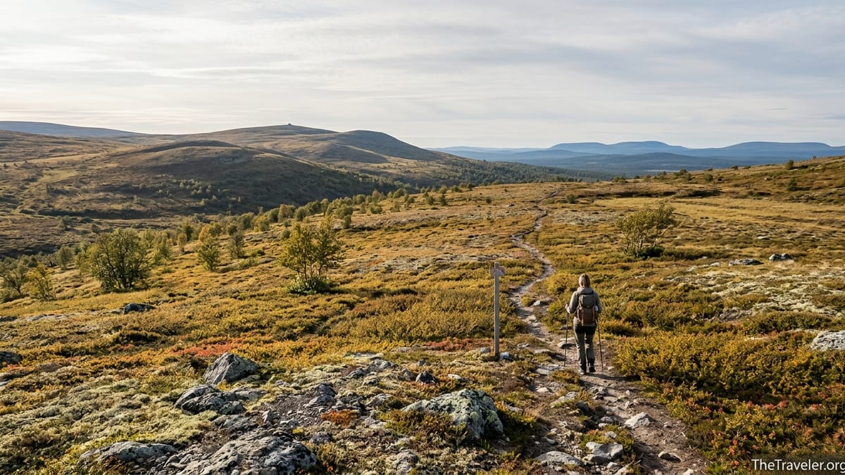
The hiking routes in Urho Kekkonen are typically divided into two categories that reflect both their character and their intended users. Around Saariselkä, Kiilopää and Tankavaara you will find a network of shorter “Out onto the Fell” day trails that are clearly waymarked, signposted and maintained to a standard most independent travelers will recognize from other Nordic parks. Beyond these lies the “Out into the Wilderness” zone of unmarked or sparsely marked routes across open fells and marshes, where travelers are expected to have solid outdoor skills.
Examples of the fell loop category include the Aurorapolku Trail, a roughly 1.2 kilometer loop that begins near Saariselkä and climbs gently onto an open vantage point ideal for viewing the northern sky, and the Rumakuru Trail, a 12 to 14 kilometer route that winds across open fell tops and through a rocky gorge before returning to its starting point. These loops are ideal for visitors with limited time or for those who want to experience fells without committing to overnight trips. Signposts at junctions and color coded symbols painted on poles or rocks make it possible to follow the trail with minimal map checking in good weather.
The wilderness routes, by contrast, are not usually marked continuously on the ground even if they appear as dotted lines on maps. A classic example is the multi day route to Lake Luirojärvi, often described as one of the pearls of the park. From trailheads such as Kiilopää or Aittajärvi, hikers cross open fell plateaus and wide river valleys with only occasional cairns or stakes to hint at the suggested direction. On such routes, you must be able to read contour lines, use a compass or GPS, and judge river crossings independently. They are not suitable for those who have only walked in well manicured Central European national park paths.
For winter, the same division applies in broad terms. Machine groomed ski tracks radiate from Saariselkä and Kiilopää into the park, signed with distances and hut names. Beyond them lie more remote ski touring lines where you travel in unbroken snow using your own judgment about avalanche free slopes and safe lake ice. Before committing to any trip in March or April, it is a good practice to discuss current snow and ice conditions with the staff at the visitor centre who see many parties coming and going each day.
Highlighted Trails and What to Expect on Each
Even though Urho Kekkonen National Park can feel limitless, a handful of trails come up again and again in visitor reports because they combine beautiful scenery with relatively straightforward logistics. The Aurorapolku Trail near Saariselkä is the easiest gateway walk, taking most people less than an hour. It briefly enters the park from the edge of the village and leads to a simple viewing area away from street lights. In summer it is a family friendly stroll on a clear path, while in winter it becomes a compact snowshoe outing for visitors hoping to watch the aurora borealis.
A step up in length and variety is the Rumakuru Trail, which in summer is around 14 kilometers and in winter about 12.5 kilometers due to slightly different routings. The trail typically starts from the Saariselkä area, climbs through birch forest onto more open fell country and then drops into the Rumakuru ravine before looping back via another fell. Facilities along or near the route usually include at least one day hut or lean to shelter and marked campfire spots, so many walkers carry a simple packed lunch and plan to rest at these mid trail. Good waterproof footwear is important in early summer when meltwater turns some sections muddy.
For those ready to go beyond day hikes, the Luirojärvi Lake route is the park’s flagship multiday trek. Distances and exact itineraries vary, but a common plan is four to six days of hiking between trailheads such as Kiilopää, Aittajärvi and Raja Jooseppi. Hikers aim to camp or stay at open wilderness huts that dot the route, spending a night at or near Luirojärvi where a small sauna and lakeshore views provide a memorable midpoint reward. Terrain alternates between rounded fells with wide views and lower valleys where dwarf birch and willow grow, and river crossings can be ankle to knee deep in early summer.
In winter, many visitors do not think in terms of named trails but of day loops from ski centers and hut to hut ski tours. A typical beginner friendly day might be a 15 to 20 kilometer cross country ski from Kiilopää along groomed tracks to a hut like Niilanpää or Rautulampi, where you can warm up by a stove before returning along another loop. More advanced groups with experience in winter camping may link huts across the interior for a week, pulling pulks and staying wherever they arrive by late afternoon. Maps of the groomed winter trail network are published each season and available locally, and should be checked carefully because the routes are not always identical to summer paths.
Visitor Centres, Huts and Other Key Facilities
Even though the bulk of Urho Kekkonen’s area is wilderness, visitor facing services are well organized by Scandinavian standards. The main official visitor centre for the park is located in the Kiilopää area, operated by Metsähallitus in cooperation with the Suomen Latu outdoor association. Here you can obtain the latest printed maps and route leaflets, ask about current trail conditions, check hut usage rules and watch a short exhibition about the nature and Sámi culture of the region. Staff often speak English and can provide practical advice such as which bridges are out, where reindeer herders are working and which huts have been particularly busy.
Saariselkä village does not have a full independent national park visitor centre, but tourist information points and many hotels maintain up to date trail maps and basic park brochures in their lobbies. Outdoor shops in the village rent equipment like snowshoes, cross country skis and camping gear, and staff are usually familiar with which trails suit different fitness levels. For example, a family staying at a mid range hotel can easily rent snowshoes for a day, receive a photocopy of the Aurorapolku and nearby loops, and head straight into the park without a car.
Inside the park, one of the defining features is the dense network of wilderness huts and day shelters. These vary from simple open huts with wooden sleeping platforms and a stove, which are free to use on a first come basis, to reservable huts where you must book a bed in advance and pay a nightly fee. In the western fell area, distances between huts are often around 10 to 20 kilometers, making it possible to plan multi day routes even in winter short daylight. Each hut is marked on official maps with distinct symbols showing whether it is open, reservable or a day use shelter, so study the legend carefully while planning.
Camping is allowed in most parts of the park under Finland’s everyman’s rights and specific national park rules, but near huts there are usually designated tent spots to reduce impact. Firewood is supplied to many huts and designated campfire sites, but you should not assume it will always be plentiful. Rangers and visitor centre staff encourage visitors to use gas stoves for routine cooking, saving firewood for warmth and emergencies, especially in colder months when helicopter or snowmobile delivery is limited.
Seasonal Conditions: When to Visit and How to Prepare
Urho Kekkonen National Park is open year round, but the experience differs dramatically by season. From June to September, the park is primarily a hiking destination with snow free fells, unfrozen rivers and long daylight hours. In midsummer around late June and early July, the sun barely sets and you can walk late into the night with only a dim twilight. This is also when mosquitoes are at their worst in the low valleys, so many hikers time their trips for late August or early September when autumn colors are at their peak and the bugs have largely disappeared.
Winter usually dominates from November into April. Deep snow covers the fells, and daylight is extremely short around the winter solstice. However, from February onward, both the light and snow conditions align for prime ski touring and snowshoeing. In March, trail reports commonly mention groomed tracks in excellent condition and solid lake ice. Temperatures can still fall below minus 20 degrees Celsius, so proper winter clothing, insulated boots and layered gloves are essential. Many visitors use heated cabins or hotels in Saariselkä and Kiilopää as comfortable bases rather than camping.
Shoulder seasons bring their own challenges. In late May and early June, snowmelt swells streams and makes some routes boggy or temporarily unsafe to cross. Bridges are placed only at select points, so melting ice and high water may force detours. Similarly, in October and early November, there can be early snow and ice but not enough to support skis or snowshoes, while daylight shrinks rapidly. If your itinerary falls in these transition months, keep it flexible and rely on up to date information from local sources rather than fixed expectations based on guidebooks written in ideal conditions.
Regardless of season, the park’s northern latitude means weather can change quickly. On a July day you might start in sunshine wearing a light base layer, then find yourself in wind driven rain by afternoon at higher elevation. Even when hiking only short fell loops, carry a waterproof shell, a warm midlayer, hat and gloves, plus enough food and water to be comfortable if you move more slowly than planned. For winter visits, many experienced travelers also pack a lightweight emergency bivouac bag or small insulating pad, even when only planning day trips on groomed tracks.
Getting There, Getting Around and Practical Logistics
From an international visitor perspective, one of Urho Kekkonen’s advantages is how simple it is to reach the western gateways without a private car. Most travelers fly to Ivalo Airport, which has regular connections from Helsinki and, in peak winter seasons, additional charter or seasonal flights from other European cities. From Ivalo Airport, shuttle buses and scheduled services typically run to Saariselkä in around 30 minutes, stopping at major hotels and apartment clusters along the way. Tickets are commonly purchased online in advance or directly from the driver using card payments.
Once in Saariselkä, many visitors happily spend several days hiking or skiing without ever hiring a car. The village is compact, with accommodation, supermarkets, gear rental shops and restaurants all within walking distance. The edge of Urho Kekkonen National Park is usually less than a 15 minute walk from most lodging clusters, with a clear gate structure and large map board marking the transition from village to park. For reaching Kiilopää or Tankavaara from Saariselkä, regional buses and occasional ski buses operate on published timetables, though frequencies may be limited outside holiday peaks.
If you are planning a multi day trek that starts and ends at different trailheads, consider using local taxi services to connect points like Aittajärvi, Kemihaara or Raja Jooseppi. These remote roadheads are not connected by regular buses, so hikers often budget for at least one taxi transfer at the beginning or end of a route. Splitting the cost among a small group can make this manageable, especially compared to renting a car that sits unused for days. When you discuss your plan with the driver, show your map and clearly identify which parking area or bridge you mean, since there can be multiple similar names along the same river.
In terms of daily logistics, expect prices in line with other remote parts of Finland. A sit down restaurant meal in Saariselkä typically costs the equivalent of a mid range European city, while self catering with groceries from the local supermarket is more economical. Gas canisters, freeze dried meals and common outdoor supplies are usually available from village sports shops, and rental prices for cross country skis or snowshoes are comparable to other Nordic resorts. If you are on a tight budget, it is sensible to bring specialized gear from home and only rely on local rentals for bulky items like skis that are impractical to fly with.
The Takeaway
Planning a visit to Urho Kekkonen National Park starts with getting the right maps and trail information, but the real reward lies in how easy it is to step from organized ski resort comfort into genuine arctic wilderness. By basing yourself in Saariselkä or Kiilopää, you can spend one day on a gentle fell loop like Aurorapolku, the next tackling a longer route to Rumakuru gorge, and perhaps later in your trip headed out with a full pack toward remote huts and lakes like Luirojärvi. The infrastructure is there to support both casual visitors and serious trekkers as long as you match your route choice to your skills.
Before you go, think through season, clothing and navigation. Obtain an up to date overview map from Metsähallitus, add a detailed topographic map for your chosen area, and store offline digital maps as backup. Check in with the visitor centre staff about current conditions, be conservative about your daily distances in subarctic terrain, and remember that the weather can shift quickly even in the height of summer.
With those preparations in place, Urho Kekkonen rewards you with big skies, quiet valleys and a sense of space that is increasingly rare in Europe. Trails begin almost at your doorstep in Saariselkä, yet a couple of days’ steady travel carry you far from any road noise. Whether your goal is to ski from hut to hut under the winter stars or to watch autumn colors ripple across the fells from a lakeside sauna, this national park offers a vast, well mapped canvas for your own Lapland adventure.
FAQ
Q1. Do I need a guide to hike in Urho Kekkonen National Park?
In the well marked western fell areas near Saariselkä, Kiilopää and Tankavaara, experienced hikers usually manage independently using official maps and signposted routes. For longer wilderness trips toward places like Luirojärvi or Raja Jooseppi, a guide is not mandatory but can be very helpful if you lack experience in subarctic navigation, river crossings or winter camping.
Q2. Where can I get official trail maps when I arrive?
The most reliable sources are the Metsähallitus visitor centre in the Kiilopää area and tourist information points or outdoor shops in Saariselkä. They usually stock free overview leaflets showing the whole park and sell durable 1:50,000 scale hiking maps that cover the main trail networks and hut locations.
Q3. Are there easy family friendly trails in the park?
Yes. Short loops like the Aurorapolku Trail near Saariselkä or local fell circuits starting from Kiilopää offer gentle gradients and clear markings suitable for families. Many families also choose out and back walks to nearby shelters or viewpoints that can be adapted to the children’s energy levels on the day.
Q4. Can I camp anywhere inside Urho Kekkonen?
In general, camping is allowed in most parts of the park, but there are specific rules near huts, fire sensitive areas and research zones. Around popular huts and shelters, designated tent sites are provided to reduce impact. It is good practice to confirm detailed regulations with the visitor centre and to use existing tent spots whenever possible.
Q5. How cold does it get in winter and what should I pack?
Winter temperatures can drop below minus 20 degrees Celsius, especially in January and February, with wind on the fells making it feel even colder. Pack layered clothing including a moisture wicking base layer, insulating midlayers, a wind and waterproof shell, insulated boots, warm gloves or mittens, a hat that covers ears and spare dry socks and gloves in case your first pair gets wet.
Q6. Is public transport enough for a hiking trip without a rental car?
For day hikes and short stays based in Saariselkä or Kiilopää, public transport is usually adequate. You can fly to Ivalo, take a bus to your accommodation and walk directly into the park from the village. For linear multi day routes that start and end at distant trailheads, you may need to budget for at least one taxi transfer to connect remote parking areas.
Q7. Are wilderness huts free to use and do I need to book?
Open wilderness huts are generally free and operate on a first come, first served basis, intended for short stays of one or two nights. Reservable huts require advance booking and a fee, which guarantees a sleeping place. Both types are marked differently on official maps, so be sure you understand which huts on your planned route are open and which require reservations.
Q8. What kind of wildlife might I see on the trails?
Common wildlife sightings include reindeer, which are semi domesticated and herded throughout the region, as well as birds such as willow grouse and Siberian jay. More elusive species like wolverine and golden eagle inhabit the park but are rarely seen. It is important not to feed wildlife and to keep a respectful distance from all animals you encounter.
Q9. When is the best time to see the Northern Lights in the park?
The Northern Lights are visible on dark, clear nights roughly from late August to early April, with higher chances during the darkest months. In practice, many visitors plan trips between September and March, combining daytime hiking or skiing with evening excursions to open fell viewpoints such as those reached by the Aurorapolku Trail.
Q10. Do mobile phones work inside Urho Kekkonen National Park?
Mobile coverage is generally good around Saariselkä, Kiilopää and the nearby fell tops but becomes patchy or absent deeper into the wilderness, especially in low valleys. You should not rely on a phone as your sole navigation or safety tool. Carry paper maps, a compass and, for longer or winter trips, consider renting a satellite messenger or emergency beacon if you are traveling far from the main routes.