
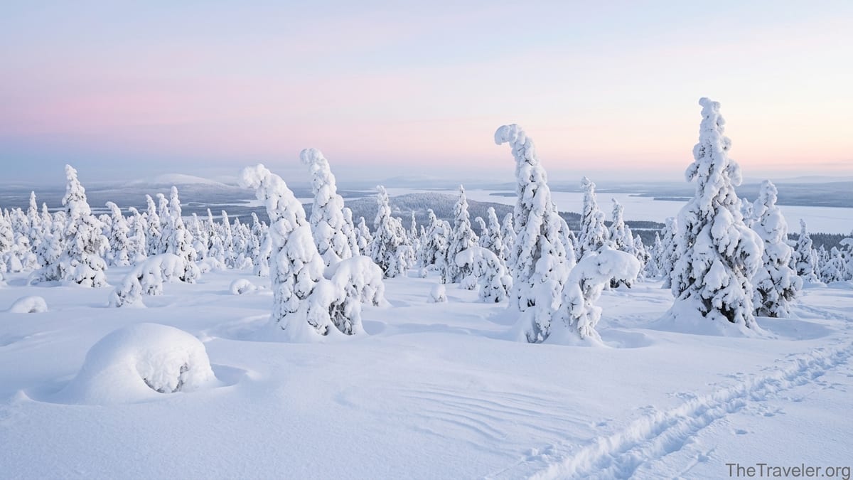
On a clear winter day at Riisitunturi National Park, the spruce trees turn into snow ghosts and the horizon glows pink over the Kitka lakes. In summer, the same fells are carpeted with cloudberries and soft tundra moss. Whether you are coming for dreamy winter photographs or a quiet summer hike, having reliable trail maps and solid visitor information will make the difference between a magical day out and a frustrating one.
Get the latest updates straight to your inbox!
Where Riisitunturi Is and Why It Feels So Remote
Riisitunturi National Park sits in southern Finnish Lapland, in the municipality of Posio, north of the large Yli-Kitka lake and roughly between the towns of Rovaniemi and Kuusamo. Driving from Rovaniemi you follow the main road toward Kuusamo for a little over two hours in good conditions, while from the Ruka / Kuusamo ski area the journey is closer to 40 minutes. That relative remoteness is part of Riisitunturi’s charm: it feels wilder and quieter than many of Finland’s more famous parks, but is still reachable in a day trip if you plan ahead.
The park protects a landscape of rounded fells, old spruce forests and open bogs typical of this part of Lapland. The main Riisitunturi fell rises modestly by Alpine standards, but the views east over the Kitka lakes and west toward Posio are expansive. For visitors, this means most trails include a steady climb at the start and a rewarding panorama at or near the top. The terrain is not technical, but snow, ice and winter darkness can make even an easy path feel serious if you are not prepared.
Metsähallitus, the Finnish state body that manages national parks, keeps Riisitunturi deliberately simple: there is no big visitor center at the trailhead, no hotel inside the park, and only a few basic buildings such as wilderness huts and lean-to shelters. That simplicity underlines how important it is to arrive with your own maps, clothing and snacks, because once you step away from the car park, you are largely on your own.
Getting Oriented: Official Maps and Reliable Trail Information
The most reliable starting point for maps and trail descriptions is the official Metsähallitus hiking portal for Riisitunturi and its downloadable brochures. The park’s winter trail leaflet, updated in late 2025, includes a clear overview map of the snowshoe and winter routes, key elevation points and emergency information. It is worth printing this at home or saving an offline copy to your phone before you travel, because mobile coverage around the fells can be patchy.
At the main Riisitunturi parking area, information boards in Finnish and English show an overview of the park with color coded trails. These boards are useful for last minute checks, but they are not a substitute for a proper map on the trail. For a more detailed topographic view, many hikers use Finnish mapping apps that draw on the national terrain database, which shows contour lines, marshes and marked routes. However, winter visitors should always compare any digital route with the current official winter trail map, as snow conditions and maintained paths change from year to year.
If you prefer a traditional paper map, outdoor stores in Rovaniemi, Kuusamo and Ruka usually stock 1:50,000 scale maps that cover Posio and Riisitunturi. These are designed for general hiking and include nearby attractions like Korouoma canyon and Oulanka National Park, making them a good choice if Riisitunturi is only one stop on a wider Lapland trip. Even with a GPS-equipped phone, having a paper backup that works without batteries is strongly recommended in midwinter.
Main Summer Trails: From Easy Loops to Full-Day Hikes
In snow free months, Riisitunturi offers a small but satisfying network of marked hiking trails that all start from existing parking areas. The classic choice for first-time visitors is a loop that climbs from the main parking area along a gravel path toward the fell top before circling back through spruce forest and open mires. Families with school-age children often pick this trail because it delivers the famous views and photogenic deadwood trees without requiring specialist gear or long days on the move.
More experienced hikers can connect routes toward Kirintövaara, a fell near Posio with its own parking area and small resort. The Riisitunturi Trail, a long-distance route around 26 kilometers between the Riisitunturi parking area and Kirintövaara, is usually tackled as a one-way day hike with a car shuttle, or as an overnight trip using lean-to shelters along the way. For example, a common pattern is to leave one car in Kirintövaara, drive the other to Riisitunturi in the morning, then walk the full trail over 8 to 10 hours, enjoying lunch at a shelter and finishing with dinner back in Posio.
For walkers staying in the Ruka ski area, Riisitunturi can be combined with nearby Oulanka National Park and the Karhunkierros Trail to create a multi-day Lapland hiking holiday. One realistic itinerary is to spend two days based in Ruka hiking sections of Karhunkierros, then rent a car for a day to explore Riisitunturi and end with a relaxed evening in Posio or back in Ruka. Because distances in Lapland can be deceptive, it pays to look at a proper map and factor in the drive between these trail systems.
Winter Routes: Snowshoe and Ski Trails in Deep Snow
Riisitunturi is especially famous in winter when heavy rime ice covers the spruce trees and turns the fell into a surreal landscape. To handle deep snow safely, Metsähallitus maintains specific winter routes that often differ from the summer paths. The most popular is a marked snowshoe loop often referred to as Riisin rääpäsy, roughly four to five kilometers long and usually recommended to be walked clockwise. Guided tours from Ruka or Posio bring guests here almost daily in high season because the trail offers a relatively short but intense experience of snow ghosts and wide views.
On this loop, guides typically allow two to three hours for the walk, including stops for photographs and a break at one of the lean-to shelters. Independent visitors should budget similar time, especially if they are new to snowshoes or are traveling with children. A typical rental snowshoe package in Ruka or Posio costs the equivalent of 20 to 30 euros for a day, often including poles. Many local tour companies also rent winter clothing sets, which is vital in midwinter when temperatures can fall well below minus 20 degrees Celsius and wind on the fell makes it feel even colder.
In addition to snowshoe routes, there is usually a maintained ski track from the village of Tolva toward Riisitunturi in midwinter, running for about seven kilometers to a wilderness hut near the fell. This track tends to operate from around mid January to late April, depending on snow and grooming resources. It provides an appealing point to point ski for intermediate skiers who want a quieter alternative to the busy tracks around major ski resorts. As always, you should confirm current grooming status with local tourism offices or online trail reports before committing to a long ski.
Access, Parking and Public Transport: How to Actually Get There
Although Riisitunturi feels remote, getting there is straightforward by car. The main Riisitunturi parking area sits at the end of a side road off Patoniementie near the tiny settlement of Tolva. Official guidance highlights that navigation apps sometimes propose unreliable shortcuts, so it is better to follow the signposted junction around Patoniementie 180 in Posio and then drive about three kilometers along a gravel road to the car park. The parking area holds roughly 200 vehicles and is plowed in winter, but it can still fill up during Christmas, New Year and peak February weeks, so arriving early in the day is wise.
A second access point is the Kirintövaara parking area near the Kirikeskus accommodation complex just outside Posio. In summer this serves as a starting point for local trails and the long Riisitunturi Trail toward the national park. Staying a night at Kirintövaara can be practical if you want to walk one way between the fell and Riisitunturi without dealing with a long end-of-day drive. During shoulder seasons, always check whether local roads to these trailheads are open; spring thaw in late April and early May often leads to soft, rutted gravel that authorities may temporarily close to protect the surface.
For visitors without a car, Riisitunturi is harder to reach. There is a regular long-distance bus service between Rovaniemi and Kuusamo via Posio, which allows you to reach the town itself, but there is no scheduled public transport from Posio to the Riisitunturi trailheads. In practice, travelers either join a commercial tour that includes transport from Rovaniemi, Ruka or Posio, or arrange a local taxi from Posio, which may cost in the range of 40 to 80 euros one way depending on season and time of day. Because taxi availability in small Lapland towns can be limited, advance booking is essential, especially for return trips after dark.
Facilities, Services and Safety on the Trails
Riisitunturi is managed as a low infrastructure park, which means facilities are limited but well maintained. At or near the main parking area you can expect a dry toilet, information boards, and in winter sometimes a small kiosk or service van run by local entrepreneurs on the busiest days. On the trails themselves there are a handful of lean-to shelters and campfire spots equipped with fire rings and a basic firewood supply maintained by Metsähallitus. These shelters are free to use, but visitors should be prepared for simple conditions: no reservations, no staff and no covered seating beyond the shelter itself.
Potable water is not provided at trailheads or along most routes. In summer, many locals boil or filter stream water, but for international visitors it is safest to bring all drinking water with you, especially for shorter day hikes. In winter, melting snow is possible if you have a stove and fuel, yet this is time consuming and better suited to experienced backcountry travelers. As a practical example, a family of four doing the popular winter snowshoe loop will comfortably drink two to three liters of hot tea and water over the course of three hours, so carrying a couple of insulated flasks is a simple way to stay warm and hydrated.
Mobile coverage in the park is generally reasonable but not guaranteed in every hollow or forested area, particularly for foreign SIM cards roaming on local networks. Carrying a fully charged phone with an offline map app is still worthwhile because it lets you check your position against the marked trail if clouds or snow blur landmarks. Finnish authorities also encourage hikers to note the national emergency number, 112, and to be ready to describe their location in simple terms such as the name of the trail, nearest shelter and approximate distance from the parking area.
Best Seasons to Visit and What to Expect
The most photogenic period in Riisitunturi is typically midwinter, from late December through February, when snow depth is at its peak and the spruce trees take on thick rime ice. During this time daylight is short, particularly around the turn of the year, with only a few hours of usable light near midday. Many photographers time their hike so that they reach the open fell for the pale pastel sky of the brief Lapland daylight, then descend by headlamp. If you follow this pattern, make sure your headlamp batteries are fresh and that you are comfortable navigating in low light on snow.
By March and early April, days are longer, the sun feels warmer and snow conditions are often excellent for snowshoeing and cross country skiing. This is a favorite period for Finnish families, who may combine a ski holiday in Ruka with a day trip to Riisitunturi, bringing packed lunches to grill at the lean-to shelters. Trails at this time can be busier, but the atmosphere is relaxed and social, with children sledding near the parking area while adults take turns snowshoeing part of the loop.
Summer, from late June through August, brings completely different experiences. The bogs are lush and green, cloudberries ripen on the mires and mosquitoes appear in earnest. Temperatures are mild rather than hot, usually in the low to mid teens Celsius, but the combination of damp ground and insects makes good footwear and insect repellent essential. Autumn, especially September, offers colorful foliage and fewer mosquitoes, with the added possibility of early-season northern lights above the fells. On the other hand, early winter in November can be challenging, with thin snow cover, ice and little daylight, so this is the time when flexible planning and cautious trail choices matter most.
The Takeaway
Planning a visit to Riisitunturi National Park begins with good information: up to date official maps from Metsähallitus, realistic expectations about trails and seasons, and a clear plan for how you will get to and from the trailheads. Once those basics are in place, the park rewards you with some of Lapland’s most atmospheric winter landscapes and quietly beautiful summer hikes, all without the heavy crowds of larger resorts.
For many travelers, Riisitunturi ends up being the highlight of a broader Lapland itinerary that might also include Rovaniemi, Ruka or nearby Oulanka National Park. Whether you are snowshoeing the short Riisin rääpäsy loop with a local guide, hiking the longer Riisitunturi Trail between Kirintövaara and the fell, or simply taking a slow walk up from the parking area to watch the sky change color over the Kitka lakes, the combination of simplicity and grandeur makes the park unforgettable. With the right preparation, your own visit can be both safe and quietly spectacular.
FAQ
Q1. Do I need a car to visit Riisitunturi National Park?
In practice, a car or an organized tour is the easiest way to visit. There is long-distance bus service to Posio, but no regular public transport from Posio to the Riisitunturi trailheads, so you would need a taxi or prearranged transfer.
Q2. Where can I find the most reliable trail maps for Riisitunturi?
The most reliable sources are the official Metsähallitus hiking pages and their downloadable brochures, including the winter trail leaflet. Supplement these with a Finnish topographic map or a reputable hiking app with offline maps.
Q3. What is the easiest trail for first-time visitors in winter?
The popular Riisin rääpäsy snowshoe loop, around four to five kilometers and usually walked clockwise, is the standard choice. It offers classic snow ghost scenery and big views without requiring advanced skills.
Q4. Is Riisitunturi suitable for children and beginners?
Yes, provided you choose shorter trails, dress properly for the weather and bring enough food and hot drinks. Many Finnish families hike here year round, but in winter young children may be more comfortable in a pulk or sled on shorter routes.
Q5. Are there entrance fees or permits required?
No, entrance to Riisitunturi National Park is free and no permits are required for basic day hiking. You may, however, pay for services such as equipment rental, guided tours, parking in some private lots or local transport.
Q6. Can I hike the trails on my own without a guide?
Yes, most marked trails are designed for independent visitors and are clearly signposted at junctions. In winter, many first-time visitors still choose guided tours for safety, local knowledge and included transport from Ruka, Kuusamo or Rovaniemi.
Q7. What kind of clothing and gear do I need in winter?
Plan on layered clothing, a windproof outer shell, insulated boots, gloves and a warm hat, plus snowshoes or winter traction depending on the route. A headlamp, thermos with hot drink and a small first aid kit are strongly recommended.
Q8. Are there places to buy food or rent equipment near the park?
There are no shops inside the park. Most visitors buy groceries and rent snowshoes or skis in Rovaniemi, Kuusamo or the Ruka ski resort, or arrange rentals through accommodation providers and tour companies in Posio and Kirintövaara.
Q9. Is wild camping allowed in Riisitunturi?
Short overnight stays following Finnish outdoor rules are generally possible, especially near designated lean-to shelters, but you should check the latest guidelines from Metsähallitus and always avoid damaging vegetation or leaving trace.
Q10. When is the best time to see the famous snow-covered trees?
The snow ghosts usually look their best from late December through February, when snow depth and rime ice are greatest. Exact timing varies year by year, so checking recent photos or local reports before your trip is helpful.