
Spend even a day in Great Smoky Mountains National Park and you will hear the name Sugarlands. It appears on trail signs, maps, and ranger programs, yet many travelers breeze past without really understanding what it is. Sugarlands is more than just the busy visitor center outside Gatlinburg. It is an historic Appalachian valley, a gateway to the park’s richest forests, and the logistical heart of the Smokies on the Tennessee side. Knowing what Sugarlands is, and why it matters, can transform how you experience this crowded but deeply storied corner of America’s most visited national park.
Get the latest updates straight to your inbox!
Defining Sugarlands: A Valley, a Community, a Gateway
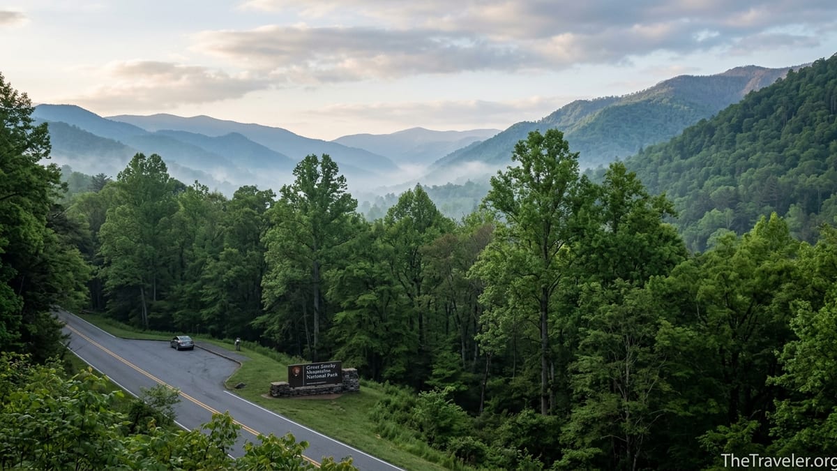
In park terms, Sugarlands is first and foremost a valley. The Sugarlands, as geologists and historians often call it, is one of the major stream valleys on the northern flank of Great Smoky Mountains National Park, similar in importance to places like Greenbrier or Cataloochee. The valley stretches roughly from the Roaring Fork drainage east of Gatlinburg to the slopes of Sugarland Mountain to the west, following tributaries of the West Prong of the Little Pigeon River as they flow out toward town. When you drive into the park from Gatlinburg on Newfound Gap Road, you are entering the Sugarlands.
Before there was a national park, Sugarlands was a scattered Appalachian farming community. In the 1800s and early 1900s, families with names like Ogle and Ownby scratched a living from these fertile bottomlands. They built log homes, churches, and small tub mills strung along the creeks. Remnants of this era remain today in stacked stone walls, chimneys, and at least one preserved cabin, giving visitors tangible glimpses of mountain life before tourism and park roads arrived.
The valley’s name likely comes from the abundance of sugar maple trees that once dominated the cove hardwood forest here, their sap used by residents to produce sweetener. That detail may seem minor, but it signals how tightly the community’s identity was tied to the land. When you walk the Sugarlands Valley Nature Trail or Old Sugarlands Trail today and notice the mix of maple, tulip poplar, and beech, you are moving through the same forest that named the place.
Modern visitors most often encounter Sugarlands through the visitor center that bears its name. Located about two miles south of Gatlinburg at the park boundary, Sugarlands Visitor Center functions as the primary gateway to the Smokies’ North District. It combines information desk, small museum, film theater, bookstore, trailhead hub, and backcountry permit office. For millions of people, this is their first stop inside the park and their introduction to what the Smokies are all about.
From Homesteads to National Park Headquarters
The transformation of Sugarlands from quiet farm valley to park headquarters mirrors the broader story of Great Smoky Mountains National Park. In the early 20th century, as the idea of a national park in the southern Appalachians gained momentum, advocates pointed to valleys like Sugarlands as evidence that the region combined rich human history with outstanding natural beauty. Over the next decades, land purchases and condemnations gradually brought the farms and woodlots under federal ownership, and former residents either relocated or negotiated life leases that expired over time.
By the time the park was officially established in 1934, many of the old Sugarlands homes stood empty. The Civilian Conservation Corps, created during the Great Depression, went to work building roads, bridges, and park infrastructure. The valley’s location so close to Gatlinburg, at the northern foot of Newfound Gap Road, made it an obvious choice for administrative headquarters and a visitor contact station. What had been a patchwork of fields and woodlots slowly evolved into the park’s operational nerve center on the Tennessee side.
Today, if you turn off Newfound Gap Road near the entrance, you will pass the low-profile park headquarters complex tucked into the trees just before you reach Sugarlands Visitor Center. These offices coordinate everything from search-and-rescue operations to trail maintenance across the western half of the park. Decisions made here affect conditions on beloved routes like Alum Cave, Rainbow Falls, and Laurel Falls that millions of people hike every year.
Walking or driving through Sugarlands with that context in mind adds depth to seemingly ordinary details. The open lawns and planted trees around headquarters sit on former homesteads. The paved roads often follow older tracks that once linked farmsteads and small churches. When rangers at Sugarlands Visitor Center share stories of early settlers or the history of logging in the area, they are not speaking in abstractions. The ground beneath your feet is the very stage where those events unfolded.
Sugarlands Visitor Center: Practical Hub With a Deeper Story
The clearest way most travelers encounter Sugarlands is through the visitor center that greets you shortly after you pass the “Entering Great Smoky Mountains National Park” sign from Gatlinburg. For practical trip planning, this building matters a lot. It houses an information desk where uniformed rangers and volunteers answer questions about everything from current bear activity to which waterfall hike might be realistic for your family’s fitness and time. On a summer morning, visitors cluster here studying trail maps and weather boards before heading up Newfound Gap Road or west toward Cades Cove.
Inside, there is a compact but thoughtfully designed set of natural history exhibits. Large mounted specimens, habitat dioramas, and interpretive panels introduce the Smokies’ biodiversity. Families often spend 30 to 60 minutes wandering through, reading about salamanders, black bears, and spring wildflowers. A free, roughly 20-minute park film plays on a loop in the small theater, offering a concise overview of how the park was created and what makes these mountains unique. Watching it before you head deeper into the park helps frame what you are about to see on the trails and overlooks.
Some visitors treat Sugarlands Visitor Center purely as a quick bathroom and map stop, but it can also function as a soft landing in the busy gateway atmosphere of Gatlinburg. It is where you can purchase detailed trail maps or guidebooks, pick up Junior Ranger booklets for children, and get the latest word on road construction or temporary closures. Travelers driving in from distant states often arrive with lists of must-do hikes they found on social media. A five-minute conversation with a ranger here can adjust those expectations to match reality, steering a family of first-time hikers from a brutally steep route to a shaded walk along a creek in the same valley.
Seasonal ranger-led programs based from the Sugarlands area add another layer of meaning. Evening talks in the nearby outdoor amphitheater, short guided walks, or special-topic presentations about everything from salamander research to Cherokee history often use local examples from the valley. When audiences then step outside, they are standing in the exact landscape being discussed, making the experience feel immediate and grounded.
Trails and Nature Walks That Reveal Sugarlands Up Close
Step away from the visitor center parking lot for more than a few minutes and Sugarlands becomes far more than an administrative label. Several trails begin right behind the building or a short drive away, offering relaxed introductions to Smokies scenery as well as access to longer backcountry routes. The most family friendly is the Sugarlands Valley Nature Trail, a half-mile paved loop that follows a gentle grade along a creek. Its level surface and short length make it accessible for wheelchairs, mobility scooters, and strollers, which is rare in a park dominated by steep, rocky paths.
Along this short walk, interpretive signs point out features that casual visitors might otherwise miss: stacked stone walls that once enclosed pastures, moss-covered chimneys from vanished homes, and tree species that dominated old farmsteads. Travelers report that the trail is a favorite early-morning or late-afternoon stop because it feels surprisingly quiet despite being only a few minutes’ drive from Gatlinburg. For someone who might not be able to tackle longer hikes, the opportunity to roll or stroll beneath tall tulip poplars and hear the creek at close range can make the Smokies feel genuinely welcoming.
Another short, rewarding path begins directly behind Sugarlands Visitor Center and leads to Cataract Falls. This easy walk along Fighting Creek usually takes under an hour round-trip and offers children the excitement of a small waterfall just big enough to feel like an adventure. Wooden footbridges, rhododendron thickets, and the sound of rushing water give visitors an immediate taste of the broader park without requiring a long drive or major elevation gain. It is a practical option for travelers who arrive later in the day but still want a meaningful first hike.
For those seeking a stronger sense of the valley’s past, the Old Sugarlands Trail begins near the visitor center and follows an old roadbed through the woods. Hikers who venture a bit farther in notice that the track feels unnaturally wide and even, lined by rock walls and occasional clearings. These clues reveal that it once served as a main route through the community, later adapted as a park road. Walking it today is like moving along the spine of a vanished town, each mossy wall or scattered daffodil patch hinting at a homestead that stood there generations ago.
Land, Water, and Stone: Why Sugarlands Matters Ecologically
The Smokies are world famous for their biodiversity, and Sugarlands provides an accessible window into that richness. The valley sits within the park’s cove hardwood forest zone, one of the most productive and species-rich temperate forests on earth. Moist, fertile soils along the creeks support towering tulip poplars, yellow buckeye, sugar maple, and American beech. In spring, the forest floor erupts with wildflowers like trillium, foamflower, and spring beauties. Even travelers who know little about botany notice how lush the vegetation feels compared with drier ridges nearby.
The network of creeks that drain Sugarlands feeds into the West Prong of the Little Pigeon River, part of a broader web of more than two thousand miles of streams within the national park. These cold, oxygen-rich waters provide habitat for native brook trout, numerous aquatic insects, and sensitive salamander species. When families pause at a bridge along the Sugarlands Valley Nature Trail or the Cataract Falls path to watch water slide over boulders, they are looking at living systems that scientists study to understand climate change and water quality across the southern Appalachians.
Geologically, the Sugarlands valley tells a quieter story than the dramatic cliffs some visitors expect from mountain parks, but its broad, alluvium-filled floor is significant. Over immense spans of time, weathering and erosion carried material from the high ridges down into basins like Sugarlands, creating deep, rock-strewn soils. These deposits made the valley attractive to early farmers and now help sustain the luxuriant forest that visitors enjoy. The gentle landforms also allowed engineers to place roads, headquarters, and campgrounds with less blasting and slope disturbance than would have been necessary on steeper terrain.
By concentrating visitor facilities in an already-disturbed valley near an existing tourist town, park planners reduced the need to carve new corridors deep into wilder sections of the Smokies. That planning decision continues to matter today. The busy parking lots and trailheads at Sugarlands certainly feel crowded in peak season, but they also serve as buffers. Many travelers are able to satisfy their desire for easy scenery, short walks, and educational exhibits without driving farther into the park, which helps keep distant hollows, high ridges, and sensitive habitats a bit quieter.
Cultural Memory and the People Behind the Name
When you are standing on the visitor center plaza waiting for your group to gather, it can be hard to picture the human lives that once filled this valley. Yet traces of those stories echo through the landscape. Features like the John Ownby Cabin, a mid-19th-century log structure preserved near the visitor center, represent actual families who built with their hands, raised children, and buried relatives here long before the national park idea took shape. Interpretive signs and ranger talks often highlight how residents grew corn and apples, kept livestock, and navigated seasonal isolation.
For travelers willing to look closely, smaller details speak just as loudly. Stone fences that meander through second-growth forest once marked property boundaries or kept livestock out of crops. Non-native plants appearing in odd clusters along trails sometimes indicate old house sites, where people planted flowers or fruit trees that linger long after cabins collapsed. When you notice an old daffodil patch blooming beneath tall hardwoods along Old Sugarlands Trail in March, you are seeing the ghost of a yard that someone tended generations ago.
The valley’s more recent history also shapes the visitor experience. Many of the roads, bridges, and early park buildings in the Sugarlands area were constructed by Civilian Conservation Corps crews during the 1930s. Their work is recognized today for helping define the “national park look” of rustic stone and timber that blends into the landscape. Even if you do not know this backstory, the aesthetic impacts the mood as you arrive: split-rail fences, low stone walls, and wood-sided buildings create a sense of continuity between human structures and the forest.
Remembering that Sugarlands was a community, not just a convenient building site, can shift how visitors interpret crowded parking lots and busy paths. This was never an untouched wilderness. Families cleared fields, logged selectively, and built mills along the creeks. The transition to a national park involved real loss and emotional complexity for the people who left. A respectful visit means recognizing that you are walking through a landscape shaped by generations of human choices as well as by rain, rivers, and roots.
Planning Your Visit: How to Make Sugarlands Work for You
Understanding what Sugarlands is helps you use it strategically during a Smokies trip. If you are arriving from the north on a busy holiday weekend, you can expect Sugarlands Visitor Center’s main parking lot to fill by late morning. Planning to stop here early in the day, before 10 a.m. where possible, gives you the best chance at a hassle-free visit. Many travelers build in 60 to 90 minutes for bathrooms, maps, exhibits, and a quick walk to Cataract Falls as a way to stretch their legs after driving in.
Accessibility is one of the biggest reasons Sugarlands matters for trip planning. The paved Sugarlands Valley Nature Trail and the relatively gentle Gatlinburg Trail, which connects the town to the visitor center along the river, provide rare options for people who use wheelchairs, push strollers, or simply prefer level walking surfaces. For families traveling with multiple generations, that can make the difference between some members staying in a cabin and everyone experiencing a forest walk together.
For hikers aiming at more strenuous objectives, Sugarlands serves as a practical staging area. Restrooms and water fountains at the visitor center allow you to prepare for longer drives up Newfound Gap Road to trailheads like Alum Cave or Charlies Bunion. Rangers here can update you on temporary trail closures, bear warnings, or recent storm damage, saving you from driving 30 winding minutes only to discover your goal is inaccessible that day. In peak season, this on-the-ground information is more reliable than a plan made weeks earlier behind a computer.
Finally, Sugarlands offers a psychological transition zone between the bright lights and restaurants of Gatlinburg and the quieter interior of the park. Spending intentional time here reading exhibits, listening to rangers, or walking beneath the trees can help you shift gears from entertainment to observation. Many repeat visitors describe pausing on a bench outside the visitor center, feeling the air become cooler and damper than it was in town, and letting the sounds of traffic fade into the background before heading deeper into the Smokies.
The Takeaway
So what is Sugarlands, and why does it matter in Great Smoky Mountains National Park? It is a layered place: once a small Appalachian farming community, now a valley that concentrates the park’s Tennessee-side headquarters, main visitor center, and some of its most accessible trails. The same fertile soils that attracted 19th-century homesteaders now support lush forests that delight modern travelers on short walks. The gentle terrain that allowed wagon roads to wind along creeks now carries Newfound Gap Road and paved paths for wheelchairs and strollers.
For visitors, appreciating Sugarlands means recognizing that this is not simply a staging area to rush through on your way to more famous viewpoints. It is both an introduction to the Smokies and a destination in its own right, where you can touch the park’s history, ecology, and daily operations within a compact radius of Gatlinburg. Whether you have half a day or a full week, building Sugarlands intentionally into your itinerary will deepen your understanding of the Smokies beyond postcard scenery.
Next time you pass the sign for Sugarlands Visitor Center or roll onto the smooth pavement of the Sugarlands Valley Nature Trail, picture the generations who lived, worked, and built the park here. Notice how the forest has reclaimed old fields, how creeks still shape the valley floor, and how today’s visitor facilities both concentrate crowds and protect wilder corners of the park. Seen through that lens, Sugarlands becomes a living crossroads of natural and human stories at the heart of Great Smoky Mountains National Park.
FAQ
Q1. Where exactly is Sugarlands in Great Smoky Mountains National Park?
Sugarlands is the valley just inside the park boundary south of Gatlinburg, Tennessee, along Newfound Gap Road. The Sugarlands Visitor Center and park headquarters sit in this valley, which extends between Roaring Fork to the east and Sugarland Mountain to the west.
Q2. Is Sugarlands just the visitor center, or is it a larger area?
The name Sugarlands refers to the broader valley and former community, not only the visitor center. The modern Sugarlands Visitor Center, nearby trails, park headquarters, and surrounding forested slopes all lie within the historic Sugarlands area.
Q3. Why is Sugarlands important to the history of the Smokies?
Sugarlands was once a small agricultural community of log homes, churches, and mills. When the national park was created, this valley became a focal point for administration and visitor contact, making it central to both the human history before the park and the story of how the park was built.
Q4. What can I do at Sugarlands if I only have an hour or two?
In a short visit you can stop at Sugarlands Visitor Center for maps, exhibits, and the park film, then walk either the easy trail to Cataract Falls behind the building or drive a short distance to the paved Sugarlands Valley Nature Trail for a gentle loop along the creek.
Q5. Are there easy or accessible trails in the Sugarlands area?
Yes. The Sugarlands Valley Nature Trail is a short, paved loop suitable for wheelchairs, scooters, and strollers, and the Gatlinburg Trail between town and the visitor center has relatively gentle grades. Both offer forest and stream scenery without steep climbs.
Q6. Is Sugarlands a good place to learn about the park’s wildlife and plants?
It is. The exhibits inside Sugarlands Visitor Center highlight the Smokies’ biodiversity, and nearby trails pass through lush cove hardwood forest along clear streams. Interpretive signs on the Sugarlands Valley Nature Trail explain tree species, historic sites, and natural processes you can see right beside the path.
Q7. How crowded does Sugarlands get, and when is the best time to visit?
Because it sits just outside Gatlinburg, Sugarlands can be very busy from late spring through autumn, especially midday and on weekends. Arriving early in the morning or later in the afternoon usually means easier parking, a quieter visitor center, and more peaceful walks on nearby trails.
Q8. Do I need to stop at Sugarlands Visitor Center before exploring the park?
You are not required to, but it is strongly recommended. Rangers at Sugarlands can provide current information on weather, wildlife activity, road work, and trail conditions, and they can suggest routes that match your time and ability. A quick stop here often prevents frustration later in the day.
Q9. Is there still any evidence of the old Sugarlands community I can see today?
Yes. Along trails such as the Sugarlands Valley Nature Trail and Old Sugarlands Trail, you can see stone walls, chimney ruins, and occasional historic buildings like the John Ownby Cabin. Non-native plants growing in patches can also indicate former home sites now absorbed into the forest.
Q10. How does visiting Sugarlands help protect the rest of the park?
By concentrating visitor facilities, parking, and easy trails in a valley already shaped by past human use, Sugarlands absorbs much of the casual visitation close to Gatlinburg. This reduces pressure on more remote hollows and ridges, helping preserve quieter habitats and backcountry experiences elsewhere in Great Smoky Mountains National Park.