


Cedar Run is one of Shenandoah National Park’s most rewarding and demanding waterfall hikes. Whether you are planning the classic Cedar Run and Whiteoak Canyon loop or just aiming for the natural waterslides and swimming holes, knowing exactly where the trail starts and what you will encounter along the way can make the difference between a memorable adventure and a grueling surprise. This guide breaks down the trailheads, the route, conditions, and practical tips so you can step onto Cedar Run prepared.
Get the latest updates straight to your inbox!
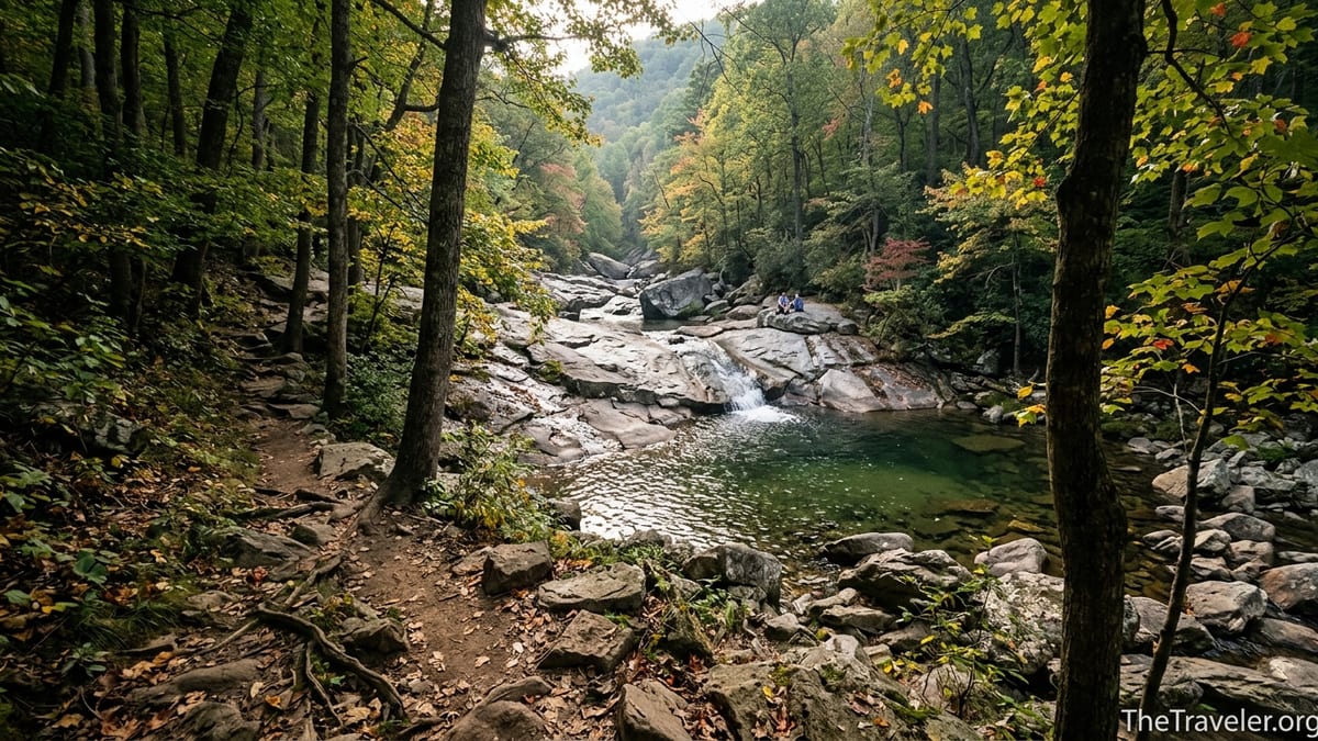
Where the Cedar Run Trail Starts
Cedar Run Trail lies near the central district of Shenandoah National Park in Virginia, in the same general area as the popular Old Rag and Whiteoak Canyon hikes. The official upper trailhead begins just off Skyline Drive at Hawksbill Gap, around milepost 45.6, on the crest of the Blue Ridge. From this parking area you drop down the east side of the ridge toward the Cedar Run drainage, eventually reaching the lower junction with Whiteoak Canyon Trail.
Most visitors coming from Washington, DC or Charlottesville reach Cedar Run via Skyline Drive, entering at either Thornton Gap or Swift Run Gap and then driving to Hawksbill Gap parking. The lot is relatively small by Shenandoah standards, so on clear fall weekends it can fill before mid‑morning, similar to what happens at Old Rag’s designated lots. In shoulder seasons or on weekdays, you are more likely to find a space even after 10 a.m., but it is still wise to arrive early and have a backup hike in mind.
If you prefer to start low and hike up, you can access Cedar Run from the Whiteoak Canyon boundary parking near Syria, Virginia, outside the park’s eastern boundary. From that entrance, you first follow Whiteoak Canyon Trail and then pick up Cedar Run at the signed junction higher in the gorge. Many local hikers based in the nearby town of Luray choose this approach because it avoids Skyline Drive closures in winter and can be reached directly from US 211.
However you start, Cedar Run is a blue‑blazed trail managed by the National Park Service. You will see standard Shenandoah wooden trail posts at major junctions and periodic blue paint blazes on trees and rocks. The trailhead signs indicate the direction to Cedar Run Trail, Whiteoak Canyon, Skyland–Big Meadows Horse Trail, and Hawksbill, which is helpful when planning loops.
Getting to the Trailhead and Parking Logistics
Driving Skyline Drive to Hawksbill Gap is the most straightforward option for first‑time visitors. As of 2026, Shenandoah National Park charges a per‑vehicle entrance fee that is valid for several days, and many hikers purchase an annual pass if they visit repeatedly. At the entry station, rangers often have a stack of printed maps that show Cedar Run and Whiteoak Canyon; it is worth asking specifically for the Whiteoak Canyon area map if you plan a loop.
Hawksbill Gap parking, at roughly 3,380 feet elevation, is shared by several hikes, including the popular Hawksbill summit circuit and the Cedar Run – Whiteoak Canyon circuit. The lot is paved with simple pull‑in spaces and has no restrooms or water, so most hikers stop at Big Meadows Wayside or Skyland Resort beforehand to use facilities and top up water bottles. For example, if you are driving up from Charlottesville, you might stop at Big Meadows, buy a sandwich or a coffee for around 10 to 15 dollars, then continue ten minutes north to the trailhead.
At the eastern boundary, the Whiteoak Canyon lower parking area operates differently. Here you pay an entrance or parking fee at a self‑service station or in person during busy periods, since you are technically entering the national park from private land. On summer weekends, the lower lot can fill by late morning and overflow onto nearby private fields, where local landowners may charge a cash fee for the day. Travelers often report paying in the range of 10 to 20 dollars to park in these overflow areas, which can add a short road walk to the start of your hike.
The choice between starting high at Hawksbill Gap or low at the boundary has practical consequences. Starting high means tackling the steep descent on fresh legs and finishing with a long climb back to your car. Starting low means grinding up the waterfalls and then descending at the end of the day. Many experienced Shenandoah hikers prefer to park high, descend Cedar Run first, then climb Whiteoak Canyon, arguing that the footing on Cedar Run’s steeper rock is more manageable on the way down than on tired legs late in the afternoon.
Trail Layout: Cedar Run by Itself and in the Classic Loop
Cedar Run can be hiked as an out‑and‑back to the waterfalls or as part of the famed Cedar Run – Whiteoak Canyon loop, which many consider one of Shenandoah’s finest day hikes. From Hawksbill Gap, the blue‑blazed Cedar Run Trail drops roughly 3 miles to the junction with Whiteoak Canyon Trail near the stream. Elevation loss over that distance is significant, roughly 2,500 to 2,800 feet depending on your exact route, which you will regain on your return if you do not form a loop.
The classic loop combines Cedar Run, Whiteoak Canyon Trail, the Whiteoak Canyon Fire Road, and a section of the Skyland–Big Meadows Horse Trail. Hiked counterclockwise from Hawksbill Gap, you descend Cedar Run to the junction, turn left onto Whiteoak Canyon and climb past a series of six notable waterfalls, then pick up the fire road and horse trail, which carry you gently back to Skyline Drive and your car. The loop is about 8 to 9 miles with significant elevation gain, and most hikers allow 6 to 8 hours with photo and swimming stops.
Starting from the lower Whiteoak boundary lot, the loop feels different. You begin on a broad path that narrows as it follows the Robinson River into Whiteoak Canyon. After passing several waterfall overlooks, you reach the upper junction where a bridge crosses the stream and Cedar Run Trail heads off on its steeper track toward Skyline Drive. Many hikers choose to ascend Whiteoak’s broader switchbacks and descend Cedar Run’s rocky grade, which tends to be more direct and demanding.
If you are short on time and only want to see Cedar Run’s signature features, you can treat it as a shorter out‑and‑back from Hawksbill Gap, descending as far as the main natural slide and pool, then turning around. This still involves several miles and some serious elevation change, but you avoid committing to the full loop. Families staying at Skyland Resort often choose this option, combining a morning hike with a late lunch on the lodge terrace.
What to Expect on the Trail: Terrain, Waterfalls, and Swimming Holes
From the first switchbacks below Hawksbill Gap, Cedar Run announces itself as a rugged mountain trail. The tread is a mixture of dirt, embedded rock, loose stone, and roots, with sections that feel more like a creek bed than a conventional path after heavy rain. In dry weather, the rocks are rough but grippy, and typical trail runners or mid‑cut hiking boots with good tread are sufficient. In wet or icy conditions, many locals recommend microspikes or trekking poles to avoid slips on smooth slabs near the water.
As you descend, the sound of Cedar Run grows louder. The stream itself is a clear, fast‑moving mountain creek that drops over ledges and slides through polished chutes. You will cross it repeatedly on boulders and stepping stones. After storms, these crossings can become tricky as water levels rise, which is why park rangers regularly caution visitors to check recent weather and be prepared to turn around if the flow is too strong. In late summer or during dry spells, crossing is usually straightforward, and children used to hiking can often manage with a steady adult hand.
One of the main attractions is the natural rock slide, sometimes called Cedar Run Falls or the Cedar Run slide. Here, the stream flows down a smooth stone ramp into a deep pool, and in warm months hikers often sit at the top and slide down like a water park ride before plunging into the cold water. You may also see people jumping from the surrounding rocks into the pool. While it looks inviting, conditions change from season to season. Debris, logs, or lower water levels can create hidden hazards, so you should always scout carefully, watch what locals are doing, and be willing to skip the slide if anything feels off.
Below the slide, Cedar Run continues through a sequence of smaller waterfalls, cascades, and quiet pools shaded by hemlock and hardwood forest. The gorge here has a remote, backcountry feel even though you are only a few miles from Skyline Drive. On crowded weekends you may still find a quiet flat rock for lunch or a short nap while you listen to the water. Wildlife sightings are common: black bear, whitetail deer, and numerous songbirds share the corridor, and it is not unusual to see a black bear browsing berries on the slope opposite the trail if you move quietly.
Seasonal Conditions, Weather, and Safety Considerations
Cedar Run is open year‑round, but each season dramatically changes the experience. In late spring and early summer, snowmelt and frequent rains keep the waterfalls full, and wildflowers like trillium and bloodroot line the lower slopes. This is also when ticks and mosquitoes become active, so many hikers wear long sleeves and treat clothing with repellent. Summer brings warmer water temperatures, making the slide and pools more comfortable, though the humidity and heat can make the climb back to Skyline Drive intense.
Autumn is arguably the most popular time for Cedar Run and Whiteoak Canyon. By mid‑October, the forests around Hawksbill and Skyland often blaze with red maples, golden hickories, and scarlet oaks, and the views from Skyline Drive are at their best. The tradeoff is crowding and limited parking. On clear October Saturdays, cars can line the shoulders near Hawksbill Gap and the Whiteoak boundary area, and rangers sometimes temporarily close lots when they reach capacity. Starting before 8 a.m. or visiting on a weekday significantly improves your chances of a smoother day.
Winter on Cedar Run is only for well‑prepared hikers. Skyline Drive can close for days or weeks after snow or ice events, which cuts off easy access to Hawksbill Gap. Even when the road is open, the shaded gorge holds snow, and the rocks around the waterfalls become coated with ice, creating both hazards and beautiful scenes. Experienced hikers come equipped with traction devices, insulating layers, and spare socks, often starting late in the morning to let the sun soften deep freeze conditions. The reward can be frozen curtains of ice over the cascades and a level of solitude that is rare in other seasons.
Regardless of season, Cedar Run’s steep grade and wet footing demand caution. It is not uncommon for Shenandoah rangers to respond to sprained ankles or minor injuries here, particularly when visitors underestimate the climb out. Plan for your ascent to take significantly longer than your descent. Carry far more water than you think you need, especially in warm weather; two to three liters per person is a reasonable starting point for the full loop. Filter systems are popular, but you should not rely solely on being able to access the stream, since high flows or icy banks can sometimes keep you from safe refills.
Gear, Fitness Level, and Who This Trail Is For
Cedar Run and its loop with Whiteoak Canyon fall firmly in the “strenuous” category of Shenandoah hikes. The combination of elevation gain and rugged surfaces means it is not a beginner trail in the same way as Dark Hollow Falls or Limberlost. That said, reasonably fit day hikers who take their time can complete it without specialized skills. If you can comfortably handle urban stair climbs or hilly 8‑ to 10‑mile walks at home, you are likely fit enough, provided you pace yourself.
Footwear matters. Trail runners with aggressive lugs or light hiking boots are ideal, especially models from mainstream brands like Salomon, Merrell, or Hoka that feature good wet‑rock traction. Smooth‑soled sneakers or worn‑down running shoes can be risky on slick granite, especially near the pools. Trekking poles are also highly recommended for the descent on Cedar Run, as they can take pressure off your knees and add stability on rock steps.
For gear, most hikers carry a small daypack with water, snacks, a shell jacket, and a basic first‑aid kit. A compact water filter lets you top up from Cedar Run or Whiteoak Canyon if necessary. Because cell reception in the gorge is spotty at best, you should download an offline map to your phone using a service like AllTrails or Gaia GPS before you lose signal at higher elevations. Park rangers frequently stress that paper maps are still valuable; you can pick one up at visitor centers such as Byrd Visitor Center at Big Meadows for just a few dollars.
Cedar Run is generally suitable for older children and teenagers who have hiking experience and enjoy scrambling on rocks, but it can be overwhelming for very young kids or anyone with balance issues. Dogs are allowed on Cedar Run and Whiteoak Canyon, but they must be leashed. Consider your dog’s temperament around steep drops and fast water; while many trail‑savvy dogs love the route, some find the rock hopping and narrow ledges stressful. In summer, paw protection may be useful on hot, sun‑exposed rock slabs.
Planning Your Day: Timings, Food, and Nearby Amenities
Because of its length and difficulty, Cedar Run is best treated as a full‑day outing. Many hikers from Washington, DC leave the city around 6 or 7 a.m., reach Thornton Gap by 8:30 or 9 a.m., and are at Hawksbill Gap trailhead by mid‑morning. A typical clockwise loop might involve descending to the Cedar Run slide by late morning, taking a break for an early lunch on a riverside rock, and then continuing up Whiteoak Canyon, reaching the fire road mid‑afternoon and the car by 4 or 5 p.m.
If you prefer a shorter day, you can set a firm turnaround time instead of a particular destination. For instance, you might decide to hike down Cedar Run for 90 minutes, enjoy a snack by the water at the most appealing cascade you reach, then head back up, regardless of whether you have made it to the slide. This approach is especially helpful for groups with mixed fitness levels or for travelers who want to be back at Skyland Resort in time for their dinner reservation.
Food and water options outside the park are limited to small country stores and diners in towns like Syria or Elkton, where you can pick up sandwiches, chips, and drinks for trail lunches. Inside the park, Big Meadows Wayside and Skyland Resort’s restaurants and taproom offer sit‑down meals or takeaway items in the 10 to 25 dollar range. Many travelers make a tradition of rewarding themselves with blackberry ice cream or a slice of pie at Big Meadows after completing the Cedar Run – Whiteoak loop.
For overnight stays, you can choose between park lodges like Skyland, campgrounds such as Big Meadows and Lewis Mountain, and private cabins or bed‑and‑breakfasts in the surrounding Shenandoah Valley and Piedmont foothills. Staying nearby the night before lets you start early and avoid the stress of a long pre‑dawn drive. Some D.C. area hikers also turn Cedar Run into part of a long weekend that includes a wine tasting at a Virginia winery or a visit to nearby Luray Caverns.
The Takeaway
Cedar Run Trail is not simply another waterfall walk in Shenandoah National Park. From its steep descent off Skyline Drive to its remote‑feeling gorge, natural rock slide, and linkup with Whiteoak Canyon, it offers a big‑mountain experience that demands respect. The trail begins right at Hawksbill Gap on Skyline Drive or effectively at the Whiteoak Canyon boundary parking below, but in either case it quickly leaves pavement and conveniences behind.
If you arrive prepared with sturdy footwear, adequate water, a printed or downloaded map, and realistic expectations about the climb back out, Cedar Run rewards you with some of the park’s most beautiful cascades and swimming holes. Combined with Whiteoak Canyon, it becomes a classic loop that many local hikers repeat year after year, adjusting the direction and pace based on water levels and seasons.
For travelers who have already visited Shenandoah’s roadside overlooks and easy waterfall trails, Cedar Run is a logical next step, offering a deeper taste of the park’s rugged side. With thoughtful planning and a margin of safety built into your day, you can experience the best of this demanding but unforgettable route and finish back at your car satisfied rather than exhausted.
FAQ
Q1. Where exactly does the Cedar Run Trail start?
The upper Cedar Run Trail starts from Hawksbill Gap parking on Skyline Drive, around milepost 45.6, and descends east into the Cedar Run drainage.
Q2. Can I start the Cedar Run hike from outside the park?
Yes. You can start from the Whiteoak Canyon boundary parking near Syria, Virginia, hike up Whiteoak Canyon, then join Cedar Run higher in the gorge.
Q3. How long is the Cedar Run and Whiteoak Canyon loop?
The full loop is roughly 8 to 9 miles, depending on your exact route, and most hikers spend 6 to 8 hours completing it with stops.
Q4. Is Cedar Run Trail suitable for beginners?
Not generally. The trail is steep, rocky, and strenuous, better suited to hikers with some experience on uneven terrain and longer elevation gains.
Q5. Are there restrooms or water at the Cedar Run trailhead?
No. Hawksbill Gap parking has no restrooms or potable water. Most people stop at Big Meadows or Skyland to use facilities and fill bottles.
Q6. When is the best season to hike Cedar Run?
Late spring and autumn are ideal, with strong waterfalls and cooler temperatures. Summer is good for swimming but can be hot and humid, while winter is icy and challenging.
Q7. Do I need special equipment for the trail?
You do not need technical gear, but sturdy footwear, trekking poles, and in winter, traction devices like microspikes are strongly recommended.
Q8. Is swimming allowed in the Cedar Run pools and slide?
Swimming is allowed but at your own risk. Conditions change with water levels, so always scout carefully and avoid sliding or jumping if anything seems unsafe.
Q9. Can I hike Cedar Run with children or dogs?
Yes, if they are experienced and comfortable on rough, steep trails. Dogs must be leashed, and you should consider their fitness and comfort around fast‑moving water.
Q10. What should I do if the parking lots are full?
If Hawksbill Gap or the Whiteoak boundary lots are full, consider returning at a less busy time, choosing a different nearby hike, or starting earlier the next day.