
On most summer mornings in Great Smoky Mountains National Park, a steady caravan of rental cars and SUVs roars past a small, unsigned turnoff near Chilhowee Lake. Drivers fixated on the famous traffic of Cades Cove never realize they have just passed the gateway to one of the Smokies’ quietest corners: the Abrams Creek area, a short side road that trades crowds and congestion for cool water, birdsong and a slower, older rhythm of the mountains.
Get the latest updates straight to your inbox!
A Quiet Corner Hiding in Plain Sight
If you trace a finger along a park map from Cades Cove west toward the Little Tennessee River, you will find Abrams Creek flowing out of the cove and through a low valley before emptying into Chilhowee Lake. The lower Abrams Creek area sits in this far western pocket of Great Smoky Mountains National Park, accessible via a short spur road off the Foothills Parkway near the community of Tallassee, Tennessee. It is technically close to big-name sights, yet feels worlds away from the busy gateways of Gatlinburg, Pigeon Forge and even Townsend.
Part of the reason so many visitors miss it is simple habit. Road signs and guidebooks tend to funnel first-time travelers toward Cades Cove and Newfound Gap Road, while Abrams Creek remains a small notation on the map, reached by a narrow paved road marked only by basic National Park Service signs. Many travelers headed for the Foothills Parkway simply stay on the through-route, never turning off toward the creek or its tiny campground. The result is a pocket of relative solitude in a park that welcomes more than 12 million visitors a year.
Those who do take the turn discover a landscape that feels more like a backcountry trailhead than a front-country destination. The access road winds beside open woods and then drops gently toward the water, where the sounds of engines fade and the constant hum of the creek takes over. On busy October weekends when cars stack up for miles at the entrance to Cades Cove, Abrams Creek can still feel surprisingly calm, with just a handful of anglers working the pools and a few campers settling in under the hardwoods.
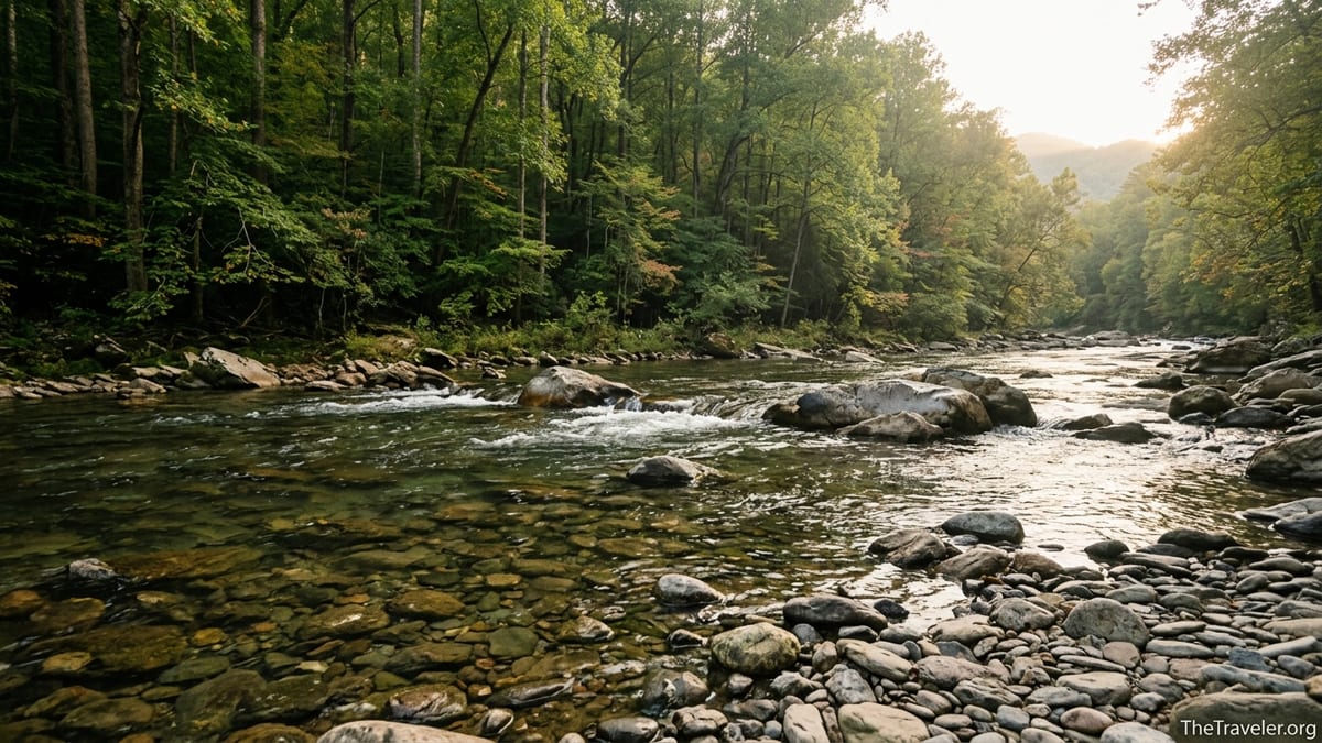
The Creek Itself: Clear, Cool and Remarkably Alive
Abrams Creek is one of the more distinctive streams in Great Smoky Mountains National Park. It begins as a high mountain stream in Cades Cove and gradually widens and slows as it approaches Chilhowee Lake, cutting through limestone bedrock that gives the water a different character from many of the park’s steeper, boulder-choked creeks. In its lower miles near the campground, the creek flows broad and clear, with long runs, deep emerald pools and cobble shallows ideal for wading on a hot afternoon.
Biologists know Abrams Creek for its rich aquatic life. The mix of spring-fed flows and limestone influences has historically supported an unusually high diversity of fish and invertebrates, including several rare and threatened species. Park research and restoration projects in this watershed have focused on protecting sensitive fish such as the Smoky madtom and yellowfin madtom, small catfish that once nearly vanished from the creek. For a casual visitor, the science translates to simple impressions: water that feels clean and cool even in August, schools of minnows flashing in the shallows, and the occasional darting trout holding in the riffles.
Spend a few minutes along the bank and you begin to notice subtler details. The water is often calm enough to clearly see river stones striped in rusty red, olive green and soft gray. Kingfishers patrol the bends, perching on overhanging limbs before plunging headfirst into the pools. On humid summer evenings, mist lifts off the surface just after sunset while barred owls call from the sycamores and tulip poplars that line the valley floor. This is the Smokies at human scale: not a sweeping overlook or a famous waterfall, but an intimate corridor of water and light.
Abrams Creek Campground: Sixteen Sites, Infinite Quiet
At the heart of this little enclave sits Abrams Creek Campground, a seasonal National Park Service campground that feels nothing like the sprawling complexes at Elkmont or Cades Cove. With only sixteen tent and small RV sites, no hookups, and limited services, it is one of the park’s smallest and quietest front-country campgrounds. Reservations are typically under 30 US dollars per night, but the real luxury here is the lack of generators and the absence of highway noise.
Sites sit under mature hardwoods, many just a short walk from the water’s edge. On a typical June evening you might see a couple from Atlanta brewing coffee on a camp stove beside Site 8 while a family from Ohio teaches their kids how to skip stones at the small gravel bar near Site 3. Instead of the constant beeping of backing RVs, the dominant sounds are the riffle upstream and occasional laughter drifting from another campsite. Bears are less habituated here than in some of the busier valleys, so food-storage rules are enforced carefully, but encounters tend to be fleeting glimpses rather than campground-wide events.
Because the campground is small, it often fills on peak summer weekends, yet it rarely feels crowded. There are no amphitheaters or large comfort stations, just vault toilets, potable water and simple paved pads. By mid-September, when leaf color starts to edge into the upper elevations, Abrams Creek becomes a favored basecamp for travelers who want early-morning access to Look Rock on the Foothills Parkway or quieter day hikes without wrestling Cades Cove’s famous traffic.
Trails and Walks: A Back Door to Abrams Falls and Beyond
For most visitors, the name “Abrams” is synonymous with Abrams Falls, the powerful 20-foot waterfall reached by a 5-mile round-trip trail from Cades Cove. What many do not realize is that the Abrams Creek area provides access to a more remote approach to this same drainage, and to a network of longer, less-traveled routes that showcase the wildness of the western Smokies.
Just beyond the campground, trailheads branch toward Hannah Mountain, Rabbit Creek and the lower Abrams Creek corridor. Strong hikers sometimes use these paths to reach the Abrams Falls area from the back side, combining sections of Hannah Mountain Trail, Rabbit Creek Trail and Abrams Falls Trail into challenging all-day loops that see only a fraction of the traffic of the main Cades Cove approach. These routes are not for beginners: stream crossings can be thigh-deep after rain, and navigation requires paying attention to signs rather than following a conga line of other visitors.
For a more relaxed outing, many campers simply follow the unofficial fisherman paths and gravel bars that parallel the creek near the campground. Short exploratory walks let you pick your way along the bank, stepping from boulder to boulder, watching for salamanders under wet rocks and enjoying shaded pools suitable for cooling your feet. In late spring you might see mountain laurel blooming along the hillsides above the water; by early October the same slopes flash with reds and golds as hickories and sourwoods change color.
The nearby Look Rock area, accessed by continuing along the Foothills Parkway, pairs naturally with an Abrams Creek day. A short walk from the Look Rock parking area leads to a stone observation platform with sweeping views of the western Smokies and out across the Tennessee Valley. Many travelers drive the parkway for this overlook alone, never realizing that just a few miles away, the quieter world of Abrams Creek offers an equally rewarding experience at ground level.
Fishing, Swimming and Simple Creek Time
Abrams Creek has long appealed to anglers, particularly those who appreciate the subtler rhythms of fly fishing. Regulations change periodically, but in general, sections of the creek are open to fishing under the park’s standard rules, with daily permits available at nearby outfitters in Townsend or at visitor centers. In the slower lower reaches near the campground, you are more likely to encounter smallmouth bass and panfish, while the cooler upstream segments closer to Cades Cove hold trout.
Even if you never string a rod, the creek invites simple contact with the water. On sultry July afternoons, families often gravitate toward shallow gravel bars where kids can splash in calf-deep current while adults sit on smooth boulders with their feet in the flow. The water is typically too swift and uneven for true swimming holes, but for wading, rock-hopping and cooling off between hikes, these stretches are ideal. Lightweight sandals or water shoes are useful; the cobbles can be slick, and broken glass is rare but not impossible in any front-country setting.
Late-day light creates some of the most memorable scenes here. Around 6 or 7 p.m. in midsummer, the sun dips behind the low ridges and the valley fills with a soft, diffuse glow. You might see a local from Maryville casting a small spinner into a pool while a pair of visiting college students from Cincinnati set up a tripod on the bank, trying to capture silky long-exposure shots of the current. Ten miles away, parking lots in Pigeon Forge are still buzzing; along Abrams Creek, the only traffic is a heron lifting off from the shallows.
How to Get There Without Joining the Traffic Jams
Reaching Abrams Creek is straightforward once you know it exists, but it is not on the main tourist loop. From the town of Townsend, many visitors instinctively head east into the park on Laurel Creek Road toward Cades Cove. To reach Abrams Creek instead, you drive west from Townsend on US 321, connect to the Foothills Parkway and then look for the signed turnoff to the Abrams Creek Campground and ranger station near the park’s western boundary. The spur road is paved but narrow and lightly traveled, suitable for passenger cars and small trailers but less comfortable for very large RVs.
This alternate routing has practical advantages. On peak days in spring and fall, it is not uncommon for the approach to Cades Cove to back up well before the loop road entrance, with drivers waiting in a slow procession for their chance to join an even slower 11-mile scenic drive. Travelers who base themselves on the “quiet side” near towns such as Townsend or Walland can often reach Abrams Creek in under an hour without ever encountering those bottlenecks. For visitors coming from Knoxville or Maryville, the Foothills Parkway approach is especially efficient, combining a scenic drive with a destination that rarely feels overwhelmed.
Parking at the campground and trailhead area is limited but generally adequate outside of holiday weekends. Because the road ends at the campground, there is no through-traffic, which means you can safely wander on foot along the pavement or the shoulder with children, something that feels less comfortable on busier park roads. Picnic tables are sparse, so many travelers bring compact camp chairs or a picnic blanket to spread on the grass near the water.
Planning a Stay: When to Go and What to Expect
The Abrams Creek area is most accessible from roughly late April through late October, when the campground is typically open and weather patterns favor comfortable nights and manageable water levels. Spring brings high, cold flows and lush wildflowers along the banks, while summer offers the warmest water for wading and long evenings at camp. Early to mid-October often provides a particularly appealing mix: cooler temperatures for hiking, developing fall color in the surrounding hardwoods and fewer afternoon thunderstorms.
Because facilities are minimal, visitors need to arrive prepared. There is no camp store on-site and no restaurant within walking distance, so groceries and fuel should be purchased in towns like Townsend, Maryville or Walland before you head to the creek. Cell service is spotty to nonexistent, depending on your carrier, which means printed maps or offline navigation downloads are useful. Standard front-country rules apply: food must be stored properly, pets must be leashed in the campground and on roads, and backcountry regulations apply if you venture onto longer trails that involve designated backcountry campsites.
Weather awareness is important in any mountain valley, and Abrams Creek is no exception. Heavy rain upstream can cause the creek to rise and cloud quickly, making rock-hopping more hazardous. Afternoon thunderstorms are common in midsummer; many locals plan longer hikes for the morning, then spend mid to late afternoon near camp, where shelter is close at hand. Because this side of the park sits at lower elevation than some of the high-elevation campgrounds, summer nights can remain warm and humid, so travelers who prioritize cooler sleeping temperatures might aim for spring or fall trips.
The Takeaway
For all of its celebrity, Great Smoky Mountains National Park is full of unsung corners where the experience feels gentler and more personal. Abrams Creek is one of those rare places: a short detour off a scenic parkway that opens into a valley of clear water, simple campsites and trails that wander into some of the park’s least visited ridges. While thousands of visitors inch their way around the Cades Cove loop in search of a glimpse of wildlife or a parking spot at a crowded trailhead, a relatively small number of travelers are listening to the same creek a few miles downstream in almost complete quiet.
If your idea of the Smokies involves campfire smoke curling through the trees, bare feet in cold water and the sound of a single creek filling the night, Abrams Creek deserves a place on your itinerary. It will not provide the postcard views of Clingmans Dome or the social buzz of Gatlinburg’s main parkway. What it offers instead is something harder to find in America’s most visited national park: the sense that the landscape is larger than the human presence in it, and that you have, for a little while, wandered into a piece of the mountains that most people still drive right past.
FAQ
Q1: Where exactly is Abrams Creek in Great Smoky Mountains National Park?
Abrams Creek is in the park’s far western section in Tennessee, near Chilhowee Lake. It is accessed via a spur road from the Foothills Parkway, reached most easily from the towns of Townsend, Maryville or Walland.
Q2: Is Abrams Creek Campground suitable for large RVs?
Abrams Creek Campground is small and designed primarily for tents and smaller RVs. The narrow access road and lack of hookups make it less comfortable for very large motorhomes or long trailers.
Q3: Do I need a reservation to camp at Abrams Creek?
Reservations are strongly recommended during the main season because the campground has only sixteen sites. Same-day availability is sometimes possible on weekdays or in shoulder seasons but cannot be relied upon.
Q4: Can I swim in Abrams Creek?
You can usually wade and cool off in the shallower sections near the campground, but there are few true swimming holes and currents can be stronger than they appear. Always check conditions and supervise children closely.
Q5: Is Abrams Creek a good place for fishing?
Yes, many anglers appreciate Abrams Creek for its clear water and mix of trout and warmwater species. A valid Tennessee fishing license with a Great Smoky Mountains National Park permit and compliance with park regulations are required.
Q6: How crowded does Abrams Creek get compared with Cades Cove?
Abrams Creek is typically far less crowded than Cades Cove. Even on busy weekends, you are more likely to find open stretches of creek and a quiet campground rather than bumper-to-bumper traffic.
Q7: Are there easy hikes for families near Abrams Creek?
Yes, short walks along the creek near the campground and gentle sections of nearby trails provide family-friendly options. However, longer backcountry routes from this area can be strenuous and require good preparation.
Q8: When is the best time of year to visit Abrams Creek?
Late spring through early fall offers the best combination of open facilities and comfortable weather. Early summer is ideal for wading, while early autumn brings cooler temperatures and developing fall color.
Q9: Is there cell service or Wi-Fi at Abrams Creek?
Cell coverage is limited to nonexistent, depending on your carrier, and there is no public Wi-Fi. Visitors should plan to be largely offline and rely on printed maps or downloaded information.
Q10: What should I bring if I plan to stay at Abrams Creek?
Plan on standard camping gear plus all food and personal supplies, as there is no camp store. Water shoes for wading, rain gear, a paper map of the area and secure food-storage containers or coolers are particularly useful.