
Ask most visitors about hiking in Bryce Canyon National Park and they will point you toward the Navajo and Queen’s Garden loop. It is iconic and crowded for good reason. Yet just a few miles away, the Fairyland Loop Trail quietly delivers bigger views, deeper solitude, and a fuller sense of the park’s wild character. For travelers willing to put in the miles, Fairyland Loop feels less like a quick postcard stop and more like stepping into the heart of Bryce itself.
Get the latest updates straight to your inbox!
What Makes Fairyland Loop So Special
The Fairyland Loop is an 8 mile to 8.5 mile lollipop loop that dives from the rim of Bryce Canyon down among hoodoos, passes beneath the cliffs of Boat Mesa, and climbs back to the rim with sweeping amphitheater views. The National Park Service rates it as strenuous because of its length and repeated elevation changes, but for reasonably fit hikers it feels like a long, immersive day out rather than a technical challenge.
Unlike the busier Queens Garden and Navajo Loop, which stay closer to the main Bryce Amphitheater, Fairyland Loop tours a quieter corner of the park on the north side of the amphitheater. The scenery is just as dramatic as the famous viewpoints, with pastel pink and cream hoodoos, windows, and fins, plus a standout feature called Tower Bridge reached by a well-signed spur trail. Yet you are likely to share long stretches of trail with only a handful of other hikers, especially if you start early.
Because the loop drops below the rim and then climbs back out, you experience Bryce Canyon’s geology from multiple perspectives. One moment you are walking the rim with distant panoramas reaching toward the Aquarius Plateau, the next you are eye level with intricately sculpted spires and bristlecone pines growing improbably out of orange slopes. That constant shift in perspective is what many repeat visitors point to when they say Fairyland, not the shorter loops, finally made Bryce “click” for them.
For travelers planning a broader Utah road trip, Fairyland Loop is also a smart value. Once you have paid the Bryce Canyon entrance fee, currently about 35 dollars per private vehicle for most visitors with the usual 7 day validity, you can ride the free park shuttle and access trailheads without extra permits. Non US residents should factor in a newer additional nonresident fee unless they hold an America the Beautiful style pass, but there is no separate reservation system for Fairyland itself, which keeps planning simpler than at some other famous Southwest hikes.
Trail Basics: Distance, Elevation, and Season
The official NPS description lists Fairyland Loop at roughly 8 miles in length, with about 1,500 feet of cumulative elevation gain spread across several climbs and descents rather than one big uphill. Most hikers take 4 to 5 hours to complete the loop at a steady but unhurried pace. Strong hikers who are used to altitude and desert conditions may move faster, but it is wise to plan for most of a day once you include photo stops and breaks.
The elevation at the rim near Fairyland Point is just over 7,700 feet, and the trail bottoms out around 7,100 feet near the floor of Fairyland Canyon before gradually climbing again beneath Boat Mesa. That high elevation is part of the trail’s appeal in summer, when temperatures in the canyon are often 10 to 20 degrees Fahrenheit cooler than surrounding low desert areas. It also means that visitors arriving from sea level, such as those flying into Las Vegas or Los Angeles and driving up the same day, may feel the thinner air and should start with a conservative pace.
Fairyland Loop is typically snow free and most popular from late May through October. Shoulder seasons like June and September often give the best combination of cooler temperatures and quieter parking lots. In winter, the scenery can be spectacular under snow, but the access road to Fairyland Point is not plowed and portions of the loop become a snowshoe or traction device route rather than a standard hike. If you are visiting between November and March, check with rangers at the Bryce Canyon Visitor Center the morning of your hike for current trail conditions and whether Fairyland is recommended that day.
Because the loop is largely exposed, with only scattered patches of shade from ponderosa and bristlecone pines, midday in July and August can feel intense despite the higher elevation. Plan water accordingly. As a practical benchmark, a couple visiting in midsummer who each carry 2 to 3 liters in hydration bladders plus a few electrolyte tablets will be more comfortable than those relying on a single small bottle. There are no reliable water sources along the route, so refill at the visitor center or lodge area before driving to the trailhead.
How Fairyland Compares to Bryce’s Famous Hikes
Nearly every Bryce Canyon itinerary mentions the Queens Garden and Navajo Loop, a roughly 3 mile to 3.5 mile combination favored for first time visitors. That loop delivers some of the park’s most photographed features, including Thor’s Hammer and the narrow switchbacks of Wall Street when that section is open. It is also close to large parking areas at Sunrise and Sunset Points and is well served by the shuttle, which together make it the busiest hike in the park.
By contrast, Fairyland Loop trades some of that instant name recognition for a more sustained and less crowded experience. Where Queens Garden and Navajo give you a concentrated 90 minute to 2 hour sampler, Fairyland offers a half day immersion. The hoodoos here are just as intricate, but the formations are spread along a longer corridor, so you are not jostling with large tour groups for every photo. Many experienced hikers describe Fairyland as feeling closer to a backcountry hike even though it remains a signed, maintained trail within sight of the rim for much of the route.
Another useful comparison is the Peekaboo Loop, which many people combine with Queens Garden and Navajo into the popular “Figure 8” route. That combination can approach 7 to 8 miles and a similar amount of elevation gain to Fairyland, but it stays more tightly within the amphitheater and often feels busier because it stacks several classic trails on top of one another. Hikers who have done both often say Fairyland feels calmer and more contemplative, particularly in the early morning when the low sun lights up the white capped hoodoos around Boat Mesa in soft peach and gold tones.
For some visitors, the right answer is not to choose at all. A common strategy is to hike Queens Garden and Navajo in the late afternoon or evening, when the light on the amphitheater is especially dramatic, then devote a full morning the next day to Fairyland Loop. That way you see both the marquee highlights and the quieter side of the park, and you can decide for yourself which deserves the title of Bryce’s best kept hiking secret.
Access, Parking, and Using the Shuttle
One reason Fairyland Loop stays relatively uncrowded is that getting to the trailhead requires a bit more intention. There are two main access points: Fairyland Point, which sits at the north end of the loop, and Sunrise Point, a major overlook just south of the main amphitheater. Driving to Fairyland Point involves taking a short side road near the park entrance to a small rim top parking lot. The National Park Service permits oversized vehicles here, which makes it a good choice for visitors traveling in RVs or campers during the main season.
Because the road to Fairyland Point is not plowed in winter and parking is limited year round, many visitors opt to park at Sunrise Point instead. This area has more spaces and is well served by the park’s free shuttle system when it runs, typically from spring through fall. When the shuttle is operating, larger vehicles such as long RVs are sometimes restricted from certain amphitheater parking areas, so checking current shuttle maps and any size limits before you arrive can save frustration.
If you choose the Sunrise Point start, one appealing approach is to walk the relatively level section of the Rim Trail north to Fairyland Point first, then descend into the canyon on the Fairyland Loop and climb back up to Sunrise at the end. This clockwise direction front-loads the easier rim walking and gives you wide angle views into the amphitheater before you drop among the hoodoos. It also means you finish close to lodge services, restrooms, and shuttle stops, which can feel welcome after several hours on trail.
For travelers staying outside the park in Bryce Canyon City, a practical real world routine might look like this: park your car at the shuttle station near the hotels around 7:00 a.m., ride the first or second shuttle into the park, disembark at Sunrise Point, hike the loop, then ride the shuttle back out for a late lunch. This avoids competing for limited parking at viewpoints during peak hours and keeps your day focused on the trail rather than circling lots in search of a space.
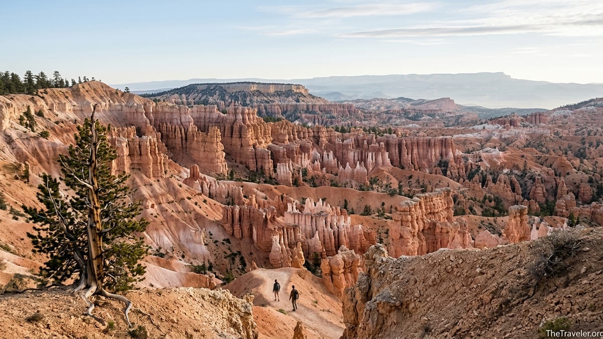
What It Actually Feels Like to Hike Fairyland Loop
Starting from Fairyland Point, the experience begins quietly at a roadside overlook where many day trippers take a quick photograph and leave. Once you step beyond the viewpoint, the trail almost immediately dips away from the rim, contouring along the edge of the amphitheater with big, open views. In the cool of early morning, you might hear only the tapping of Clark’s nutcrackers in the conifers and the distant murmur of tires on the park road far above.
As the path switches back toward the canyon floor, the world tightens. Hoodoos that were tiny from the rim become towering walls of pink, orange, and cream. In several places, the trail passes through narrow gaps and beneath rock windows carved by freeze thaw cycles over millennia. Unlike some Utah hikes known for knife edge exposure, however, Fairyland’s tread generally feels wide and secure, which makes it suitable for confident older children and adults who are comfortable with a few steeper grades but do not want cliff hugging drop offs.
Near the low point of the loop, the terrain opens again into wide washes and rolling hills of colored clay. Here you see scattered bristlecone pines and small ponderosa groves that cling to the slopes, their twisted trunks offering a living contrast to the eroded rock around them. This is a good place to take a snack break; many hikers find a sunlit boulder with views back toward Boat Mesa and watch clouds drift over the plateau while they rehydrate.
The long climb back toward Sunrise Point is where the trail earns its strenuous rating. The grade is steady rather than brutally steep, but the combination of altitude and sun can make it feel longer than the map suggests. In midsummer, hikers often use light sun shirts, wide brimmed hats, and neck gaiters to keep cool. As you gain elevation, views reopen toward the main amphitheater, and soon familiar landmarks like Sunset Point come into sight. By the time you reach the rim again, the once quiet overlooks will likely be busy with midday visitors, underscoring how different Fairyland feels from the bustle just a short walk away.
Planning Your Day: Safety, Gear, and Practical Tips
Because of its length and relatively remote feel, Fairyland Loop rewards some simple but important preparation. Water is the top priority. In summer, many experienced desert hikers aim for at least 2 liters per person for a cool day and 3 liters or more for hot days. A compact 2 to 3 liter hydration bladder in a daypack makes it easy to sip regularly. Adding an electrolyte mix or tablets from familiar brands stocked in nearby gateway towns can help prevent cramping and fatigue, especially if you are not used to exercising at altitude.
Footwear is another consideration. The trail’s surface is primarily packed dirt and gravel with occasional rockier sections and short sandy stretches. Lightweight hiking shoes or trail runners with good tread work well for most visitors. Travelers who only packed casual sneakers can still complete the hike in dry conditions, but they may find the descents more slippery and should take extra care on loose slopes. Hiking poles are optional, yet many people appreciate them on the downhill sections and during the final climb back to the rim.
Sun protection and layering are key due to Bryce’s elevation and variable weather. Even in June, mornings can start near freezing before warming rapidly into the 60s or 70s Fahrenheit. A packable fleece or synthetic midlayer, a light wind shell, and then a breathable sun shirt give you options without adding too much weight. Do not underestimate the intensity of UV at 7,000 to 8,000 feet; a wide brimmed hat, sunglasses, and frequent sunscreen reapplication will make the day more comfortable and safer.
Finally, build extra time into your schedule. It can be tempting to connect Fairyland Loop with other long hikes such as the Figure 8 combination in a single day, but for many travelers that turns Bryce into a fitness test rather than a place to savor. If you arrive from nearby parks like Zion or Capitol Reef, consider dedicating one full morning simply to Fairyland and using the afternoon for short rim walks, ranger talks, or a scenic drive out to viewpoints like Natural Bridge and Rainbow Point.
The Takeaway
Fairyland Loop is not the quickest or easiest way to see Bryce Canyon. It demands several hours, steady footing, and respect for altitude and sun. Yet for many travelers, that investment pays back in a way that a busy, shorter loop simply cannot. On Fairyland, the hoodoos feel wilder, the silences longer, and the sense of moving through an actual landscape rather than a series of viewpoints much stronger.
If your image of Bryce has been shaped mainly by a handful of famous photos, hiking Fairyland Loop can be quietly transformative. You still see the sculpted amphitheater from the rim, but you also follow the contours of Boat Mesa, stand beneath isolated spires with no one else in sight, and watch subtle shifts of light play across entire hillsides of rock. It is the difference between skimming a travel brochure and reading the full story.
For travelers planning a first visit to Bryce Canyon National Park, consider carving out half a day for this under the radar classic. Start early, carry adequate water, and give yourself permission to move slowly and look closely. By the time you emerge back onto the crowded rim, you may find yourself quietly agreeing that Bryce’s true magic is not at the overlooks but down in the so called Fairyland where the crowds rarely go.
FAQ
Q1. How long does it take to hike the Fairyland Loop Trail?
Most visitors should plan 4 to 5 hours to complete the roughly 8 mile loop, allowing time for photo stops, short rest breaks, and the optional Tower Bridge spur.
Q2. How difficult is the Fairyland Loop compared with Queens Garden and Navajo Loop?
Fairyland is longer and has more cumulative elevation gain, so it feels significantly more strenuous than the 3 to 3.5 mile Queens Garden and Navajo combination, though it remains non technical.
Q3. Which direction should I hike the Fairyland Loop?
Many hikers prefer starting at Sunrise Point, walking the Rim Trail north to Fairyland Point, then descending and completing the loop clockwise so the day ends with a steady climb back to Sunrise.
Q4. When is the best time of year to hike Fairyland Loop?
Late spring through early fall is ideal, with June, September, and early October often offering the best mix of cooler temperatures, longer daylight, and mostly dry trail conditions.
Q5. Is Fairyland Loop suitable for children and older hikers?
Fit, experienced kids and active older adults who are used to walking several miles can enjoy the trail, but its length, altitude, and limited shade mean it is not a good choice for very young children or those with limited stamina.
Q6. Do I need a permit or reservation for the Fairyland Loop Trail?
At present, no special day use permit or timed entry reservation is required specifically for Fairyland Loop, though all visitors must have a valid Bryce Canyon entrance pass or appropriate annual pass.
Q7. Are dogs allowed on the Fairyland Loop Trail?
Pets are not allowed on Fairyland Loop or most inner canyon trails at Bryce Canyon; they are generally restricted to paved viewpoints, campground areas, and a few short paved paths.
Q8. Can I hike Fairyland Loop in winter?
It is sometimes possible in winter with proper traction devices or snowshoes, but the access road to Fairyland Point is not plowed and conditions can be icy or hazardous, so always check with rangers before attempting it.
Q9. Is there water available along the Fairyland Loop?
There are no reliable water sources on the trail itself, so you should fill bottles or hydration bladders at the visitor center or near the lodge area before starting and carry all you expect to need.
Q10. How crowded is Fairyland Loop compared with other Bryce Canyon hikes?
Fairyland Loop usually sees far fewer hikers than the main amphitheater trails; on many mornings you may walk long stretches with only occasional encounters, especially away from the Tower Bridge spur.