
I thought I knew Bryce Canyon. I had stood at Sunrise Point shoulder to shoulder with hundreds of people, watched the amphitheater blush pink, and shuffled along the rim with bus tours and selfie sticks. But it was not until I stepped onto the Fairyland Loop Trail, an 8 mile circuit that dips far below the rim and circles lonely Boat Mesa, that I understood how much of this park most visitors never see. Out there, with only wind in the pines and the soft crunch of sand under my boots, Bryce Canyon felt less like a viewpoint and more like a wild, living canyon.
Get the latest updates straight to your inbox!
Finding the Trail Most People Drive Right Past
Fairyland Loop hides almost in plain sight. The main access is Fairyland Point, a signed turnoff about a mile before the Bryce Canyon Visitor Center as you drive in from Bryce Canyon City. Because the spur road comes before the entrance station, first time visitors often pass it without realizing it leads to one of the park’s best long hikes. Many people have their sights set on Navajo Loop or Queens Garden and do not want to “waste time” on an unsigned side road that looks like it leads to a simple overlook.
There are two practical ways to start the loop. You can drive to Fairyland Point and begin there, or you can park at Sunrise Point inside the main amphitheater area and hike the Rim Trail north to connect with Fairyland. The National Park Service describes the loop as roughly 8 miles with about 1,700 to 1,900 feet of cumulative elevation gain, usually taking most hikers 4 to 5 hours at a steady but relaxed pace. Parking at Fairyland Point is limited and the access road is not plowed in winter, so in shoulder seasons and winter you are often better off starting at Sunrise Point and walking out along the rim.
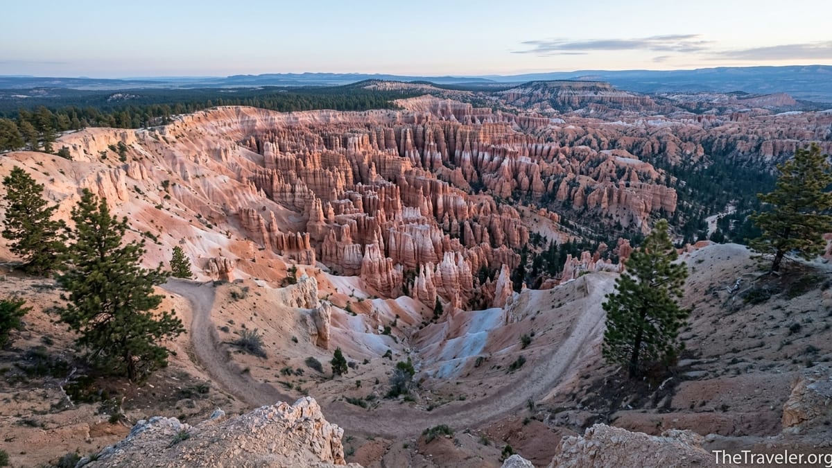
On my visit in early May, I chose the latter. I left my rental car in the paved Sunrise Point lot just after sunrise, when spaces were still abundant, and walked north along the Rim Trail. Within fifteen minutes the crowds thinned, the chatter from the lodge and general store faded, and I found myself alone on a sandy path tracing what felt like the top edge of an enormous stone bowl.
Compared with the pandemonium at Sunset Point, the northern rim feels almost abandoned. There are no tour buses idling, no steady line of visitors squeezing into a single switchback like Wall Street on Navajo Loop. Instead, you get constantly shifting views of Boat Mesa and a sense that you are walking off the edge of the map most day trippers are following.
Dropping Below the Rim Into Another World
Fairyland Loop is really two experiences stitched together: a high rim walk with big amphitheater vistas, and a deep canyon ramble among hoodoos, spires, and gullies that feel almost architectural. Most guidebooks, and the park itself, recommend hiking counterclockwise. That means leaving from Fairyland Point or the Tower Bridge junction, dropping into the canyon first, then climbing back out on a steady grade. I opted to walk clockwise from Sunrise Point, taking in the rim views first, then descending into the quiet heart of the loop.
Past the signed junction for Tower Bridge, the trail begins to unwind from the rim and step down into Fairyland Canyon. The change is immediate. The wind dies. The smell of warm pine needles and damp clay replaces the gasoline tang from the parking lots. The hoodoos rise higher around you, no longer tiny chess pieces below the overlook railings but towering columns the height of apartment buildings. The soundtrack shrinks to your breath and the occasional call of a Steller’s jay bouncing between the ponderosa pines.
There are no handrails here, no paved switchbacks, almost no sound of other people. On a midweek day in May I hiked for nearly an hour without seeing another party. When someone did appear, they were a lone backpack carrier or a couple sharing trail mix in the shade of a rock fin, not a convoy of hiking poles and Bluetooth speakers. Compared with the tightly packed queues on the Navajo Loop’s Wall Street section, Fairyland’s solitude feels almost shocking.
The geology also tells a quieter story. While the main Bryce Amphitheater dazzles in orange and cream, Fairyland’s palette feels softer and more varied. In places the Claron Formation softens into pale yellows, rose pinks, and almost white limestone, with pockets of dark green firs and pigment streaks of desert varnish. It is like walking through the backstage of the amphitheater, seeing the set from angles the audience never does.
Why Fairyland Feels So Different From the Amphitheater Loops
On paper, Fairyland Loop is not that different from the park’s more famous circuits. It is similar in length to combinations like the Figure 8 Loop that stitches Navajo, Queens Garden, and Peekaboo together. Yet the on trail experience is dramatically different, and that difference is what made Fairyland feel like a secret version of Bryce Canyon that had been waiting for me to slow down.
Crowds are the most obvious factor. The park’s own literature and private tourism sites consistently advertise Navajo and Queens Garden as the “must do” hikes for first timers. Guides, bus tours, and social media posts push everyone toward the same starting points. Fairyland Loop, by contrast, requires a half day commitment and a bit of navigation, so the average visitor with just a couple of hours heads elsewhere. That leaves Fairyland to day hikers, trail runners, and a handful of photographers who prefer empty scenes to iconic angles.
The second difference is scale. While the amphitheater loops constantly switch between tight slot style turns and postcard viewpoints, Fairyland unfolds in long, sweeping curves. You spend entire miles tracing the base of Boat Mesa or contouring around Campbell Canyon, watching individual hoodoos change shape as you pass them. It feels less like a quick highlight reel and more like a long conversation with the landscape.
Finally, Fairyland gives you a stronger sense of Bryce as a living ecosystem. The trail threads through pockets of ponderosa forest where you can actually smell the vanilla scent of sun warmed bark, and passes meadows where mule deer leave fresh tracks in the sand. I saw Clark’s nutcrackers raiding pine cones, lizards darting over sun-baked rocks, and fresh coyote scat right on the trail. On the busier amphitheater trails, wildlife often retreats from the noise; in Fairyland, you are the one tiptoeing through their living room.
Planning Your Hike: Timing, Weather, and Park Logistics
Because Fairyland Loop is longer and more exposed than most amphitheater hikes, planning matters. Bryce Canyon sits at roughly 8,000 to 9,000 feet above sea level, and the loop involves a cumulative elevation gain of around 1,700 to 1,900 feet, which many hikers feel more strongly at altitude. In practical terms, that means a route that might feel “moderate” at home can feel “strenuous” here, especially in the middle of the day.
The National Park Service recommends 4 to 5 hours to complete the loop at a steady pace. Add in photo stops, snack breaks, and time to read trail junction signs, and it is wise to block out at least 5 to 6 hours of daylight. If you start at Sunrise Point in late spring or summer, being on the trail by 7:00 a.m. avoids both the strongest sun and the busiest parking period. In cooler months, a mid-morning start can help you avoid icy stretches as the sun softens overnight frost.
Weather is a serious consideration. The park notes that Fairyland Loop can be inaccessible in midwinter when snow depths reach 2 to 15 feet and the short access road to Fairyland Point is closed to vehicles. Even in shoulder seasons, snow and mud can linger on shady north facing slopes while south facing switchbacks bake in full sun. In summer, afternoon thunderstorms can build quickly, bringing sudden downpours, hail, and lightning. Rangers at the Visitor Center post daily conditions, and it is worth checking in person before committing to the full loop, especially in spring and fall.
Entrance fees and logistics also matter, particularly for international travelers. As of 2025, Bryce Canyon charges a private vehicle entrance fee in the mid 30 dollar range for a 7 day pass, with separate per person fees for those entering on foot or by bicycle. Non United States residents aged 16 and over are subject to an additional nonresident fee unless covered by an eligible annual pass. The park is cashless, so bring a credit or debit card or purchase a digital pass in advance. If you want to connect Fairyland with other trails via the park shuttle, remember that the free shuttle serves Sunrise Point but does not go to Fairyland Point, so you cannot rely on a bus to complete the loop for you.
What to Expect on the Trail, Step by Step
Hiking Fairyland Loop feels like a series of distinct chapters. Starting clockwise from Sunrise Point, you first follow about 2.5 miles of the Rim Trail, with broad views south into the amphitheater and north toward the Dixie National Forest high country. The path undulates gently along the edge, with packed dirt underfoot and occasional rock outcrops that invite you to step aside for photos. It is common to see families out for a short stroll here before the crowd thins and you draw closer to Fairyland Point.
At Fairyland Point, a simple wooden fence and small parking area mark the northernmost tip of the rim. Many visitors pop out of their cars, snap a quick photo, and leave within ten minutes. The loop trail, however, drops away immediately from the overlook, zigzagging into Fairyland Canyon. Over the next couple of miles, you switch from open rim to intimate canyon, passing clusters of close range hoodoos and sculpted fins that rise just above eye level. The footing is mostly packed sand and small gravel, with occasional rock steps where erosion has been controlled.
Continuing around Boat Mesa, the trail sweeps into Campbell Canyon, where the sense of isolation deepens. This is where I noticed how quiet the park can be once you step more than a mile from the nearest staircase. The path threads through scattered pines, crosses dry washes, and occasionally climbs to minor saddles that provide sweeping views back to where you started. The grade rolls but is rarely brutal, although the cumulative effect over several hours can be tiring, especially for hikers unused to altitude.
The final main chapter is the climb back toward the rim near the Tower Bridge junction. Here, switchbacks gain several hundred feet in a relatively short distance. The terrain alternates between shady gullies and sun exposed slopes, and by this point most hikers are feeling the miles. On my hike I passed a couple of groups who had underestimated how long the climb would feel; they were grateful for light packs, plenty of water, and snack breaks whenever the trail passed a small patch of shade. From the junction, the main Fairyland Loop continues up to rejoin the rim north of Sunrise Point, while a spur trail leads to Tower Bridge, a natural rock arch that makes a worthwhile short side trip if your legs and daylight allow.
Gear, Safety, and Real World Trail Tips
Because Fairyland Loop is not technically difficult and is well signed, many visitors assume they can treat it like a casual stroll from the main overlooks. The reality on the ground suggests otherwise. You will be out for most of the day, far from services, with limited shade and no water along the route. The park notes that the only reliable, treated water near the area is at the General Store by Sunrise Point, and that is seasonal. Plan to carry all the water you need, ideally at least 2 to 3 liters per person for a half day hike in fair weather and more in summer.
Footwear should match the terrain. While you will see a few determined visitors in sneakers, the combination of loose sand, gravel, and occasional wet or icy patches makes lightweight hiking shoes or boots with decent tread a safer and more comfortable choice. Trekking poles can be helpful on the longer climbs and descents, especially for anyone with knee issues. In early season, I found microspikes unnecessary on Fairyland itself but useful on shaded sections of the rim path where overnight frost had not yet melted.
Sun protection is nonnegotiable. Much of the trail is fully exposed to the high desert sun, and at Bryce’s elevation the ultraviolet index can be intense even on cool days. A wide brimmed hat, sunglasses, and high SPF sunscreen applied and reapplied during breaks make a huge difference. I also wore a breathable long sleeve shirt, which felt more comfortable than slathering sunscreen on bare arms every hour. Afternoon temperatures in summer can easily climb into the 80s Fahrenheit, and the reflected heat from pale rock and sand adds to the strain.
Navigation is straightforward but worth respecting. Major junctions are signed, and a simple paper map from the Visitor Center or a downloaded offline map from a reputable hiking app can help you visualize where you are relative to the rim and the road. Cellular reception is spotty once you dip into the canyon, so do not assume you can rely on live apps. Before you leave, let someone in your group or at your lodging know your plan and expected return time, and build in a buffer for slower hikers or frequent photo stops.
Connecting Fairyland With the Rest of Your Bryce Canyon Trip
Hiking Fairyland Loop is a half day commitment, but it integrates beautifully into a broader Bryce Canyon itinerary. On a one day visit, you could start with sunrise at Sunrise Point, hike Fairyland Loop from the same trailhead, and then spend the late afternoon visiting roadside viewpoints such as Inspiration Point, Bryce Point, Paria View, and the more distant Piracy Point. Several travelers base themselves in nearby Bryce Canyon City, at simple motels or lodges, so they can walk or drive into the park before dawn and avoid a longer commute from towns like Panguitch or Tropic.
If you have two days, one popular pattern is to devote an entire morning to Fairyland, take a long break in the heat of the day, then hike a shorter amphitheater loop in the late afternoon. For example, you might walk the easy paved path between Sunrise and Sunset Points or drop partway down the Queens Garden Trail and return the same way. This gives you both the intimate below the rim experience that makes Bryce famous and the wide open solitude that defines Fairyland.
Serious hikers sometimes combine Fairyland with Peekaboo Loop and segments of the Rim Trail over two long days, using the free park shuttle to reposition vehicles between trailheads. On my visit, I met a couple training for a Grand Canyon rim to rim hike who had done Fairyland one day, then a big Figure 8 style loop the next, capping each day with a quiet sunset at less frequented overlooks farther south along the park road. Their takeaway echoed my own: Fairyland was the day that stuck with them most vividly, not because it was the hardest, but because it felt like their own private introduction to Bryce.
Whatever your timeline, build flexibility into your plan. Trails at Bryce can close temporarily due to snow, ice, rockfall, or maintenance. In 2024 and 2025, for example, sections of popular routes were periodically closed while Fairyland and Tower Bridge reopened when conditions allowed. Stopping at the Visitor Center for the latest trail status and talking with a ranger for five minutes can save you from a frustrating surprise and help you choose a route that matches current conditions and your group’s ability.
The Takeaway
Spending a day on the Fairyland Loop Trail changed my relationship with Bryce Canyon. Instead of thinking of it as a park of crowded overlooks and photogenic chokepoints, I began to see it as a broader, wilder landscape of mesas, forests, and quiet side canyons that rarely show up on postcards. In those long, quiet miles circling Boat Mesa, I found more time to notice the subtle colors in the rock, the way pinyon pines carve a living out of sandstone ledges, and the way shadows march slowly across the amphitheater as the sun swings overhead.
Most travelers will continue to head straight for Navajo Loop and Queens Garden, and there is nothing wrong with that. Those trails are famous because they are spectacular and accessible, and if you have only a couple of hours they are a fine introduction. But if you can spare half a day, if you are comfortable with a strenuous 8 mile hike and want to see a version of Bryce Canyon that feels far more personal and less scripted, Fairyland Loop shows you a side of the park that most visitors will never know.
In the end, that might be Fairyland’s greatest gift. It reminds you that even in one of the most photographed national parks in the United States, there are still places where you can walk for an hour with only your own footsteps for company and feel, just for a while, that the canyon belongs to you alone.
FAQ
Q1. How long is the Fairyland Loop Trail and how difficult is it?
The Fairyland Loop is roughly 8 miles long with about 1,700 to 1,900 feet of cumulative elevation gain. It is usually rated as strenuous due to the length, altitude, and several sustained climbs.
Q2. How long does it take to hike Fairyland Loop?
Most hikers take 4 to 5 hours to complete the loop at a steady pace, but allowing 5 to 6 hours gives you time for photos, breaks, and slower sections on the climbs.
Q3. Where do I start the Fairyland Loop Trail?
You can start from Fairyland Point, just inside the park entrance, or from Sunrise Point by walking north along the Rim Trail to the Fairyland junction. Many visitors choose Sunrise Point because parking is more plentiful and the access road to Fairyland Point can be closed in winter.
Q4. Is there water available on the Fairyland Loop?
There is no potable water on the trail itself. Seasonal water and restrooms are available near Sunrise Point at the General Store, so you should fill all bottles there and carry enough for the entire hike.
Q5. Can I take the shuttle to Fairyland Point?
No. The free park shuttle serves major viewpoints like Sunrise, Sunset, Inspiration, and Bryce Point but does not go to Fairyland Point. If you start at Fairyland Point you must either hike a full loop back to your vehicle or arrange your own transportation.
Q6. When is the best time of year to hike Fairyland Loop?
Late spring through early fall generally offers the best conditions. In winter and early spring, snow and ice can close the access road to Fairyland Point and make sections of the trail difficult or unsafe. Always check current trail conditions with rangers before setting out.
Q7. Do I need a permit or special pass to hike Fairyland Loop?
No separate hiking permit is required for Fairyland Loop. You simply need to pay the standard Bryce Canyon National Park entrance fee or show a valid pass such as an annual or America the Beautiful pass.
Q8. Is Fairyland Loop suitable for children or beginner hikers?
Fairyland Loop is generally too long and strenuous for young children or complete beginners. Families often opt for shorter options like the Queens Garden Trail or the paved Rim Trail between Sunrise and Sunset Points instead.
Q9. Can I hike just part of the Fairyland Loop?
Yes. Some visitors hike from Sunrise Point to Tower Bridge and back, which covers the southern portion of the loop and offers a taste of the scenery without committing to the full circuit. Others walk only the rim section between Sunrise Point and Fairyland Point.
Q10. Are dogs allowed on the Fairyland Loop Trail?
No. Pets are not allowed on Fairyland Loop or most unpaved trails in Bryce Canyon National Park. Leashed pets are generally restricted to paved areas such as campgrounds, some viewpoints, and certain paved paths.