
If you spend any time in New Jersey, you eventually end up on the Garden State Parkway. It might be on a summer Saturday heading to Ocean City, a predawn airport run to Newark Liberty, or a daily commute from Toms River to Newark. Yet for all the jokes about traffic and tolls, the Parkway is far more than just another busy highway. It is the spine of New Jersey travel, quietly shaping how residents commute, vacation, and even imagine their own state.
Get the latest updates straight to your inbox!
The North–South Backbone of Real Life in New Jersey
Stretching from the New York State line at Montvale to Cape May near New Jersey’s southern tip, the Garden State Parkway runs roughly 172 miles along the state’s eastern side. Operated by the New Jersey Turnpike Authority, it functions as a true backbone route, stitching together suburbs, shore towns, airports, and job centers into one continuous corridor. Without it, a routine drive from, say, Woodbridge to Toms River would mean a patchwork of local roads and state highways instead of a mostly direct, limited-access run.
The Parkway’s importance shows in how often it is used. Recent traffic counts suggest that on a typical day, anywhere from around 1 million to as many as 1.3 million vehicles travel some portion of the roadway. In peak summer months, that number climbs as shore traffic surges. For comparison, that is the equivalent of the entire population of New Jersey’s largest cities combined, moving on a single corridor in just 24 hours.
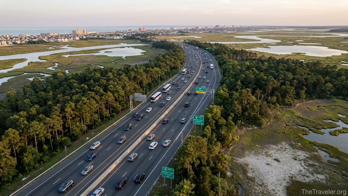
The design reflects its role as a major travel artery. In densely populated North Jersey, the Parkway often runs six or more lanes wide, feeding commuters into job hubs around Newark, the Meadowlands, and northern suburbs. South of about Exit 98, it narrows and feels more like a scenic parkway, with pine forest and marshland flanking the roadway. Yet it still carries vacationers, delivery vans, buses, and commuters who have simply traded the office tower for a job at a warehouse, hospital, or casino.
For many residents, the Parkway is the default answer to a basic question: how do I get there fastest? From shopping trips to the Freehold Raceway Mall via Exit 123 to daily commutes into Metropark near Exit 131, the road quietly dictates what feels “nearby” and which places become regular parts of life.
The Parkway as the Front Door to the Jersey Shore
Nowhere is the Garden State Parkway’s influence more obvious than in how New Jersey visits its own coastline. For generations of residents, the route to summer begins with reading exits off the Parkway: 98 for Belmar and Spring Lake, 100 for Asbury Park, 105 toward Long Branch, 63 for Long Beach Island, 4B for Wildwood, and 0 for Cape May. Family traditions and even identities are wrapped around questions like “what’s your shore exit?”
Consider a typical July weekend. A family from Clifton might leave before dawn, merging onto the Parkway near Exit 154 and heading south. They pass the Raritan Toll Plaza, roll through the long bridges over the Raritan Bay and the wetlands, and then, near Exit 98, make the decision: Point Pleasant via Route 34, or on toward Seaside Heights via Exit 82 and Route 37. For thousands of households across North and Central Jersey, that sequence of exits is as familiar as their own neighborhood streets.
Tourism businesses depend on that predictability. Motels in Wildwood expect check-ins to cluster around Friday evening when Parkway traffic begins peeling off at Exit 4A. Beach badge offices in Seaside Park know that a cloudy Saturday will still bring late arrivals from Bergen County, delayed by slowdowns around the Asbury tolls. Even boardwalk pizza shops in Ocean City feel the impact of an accident around Exit 44 that backs traffic up for miles and causes many would-be day trippers to turn around.
Because the Parkway runs inland but parallel to the coast, it also gives travelers flexibility. If thunderstorms roll across Asbury Park, drivers can cut south a few more exits to try for better weather in Atlantic City or Brigantine. In practice, this means many travelers think in terms of “Parkway zones” instead of individual towns: the sandy coves of Sandy Hook accessed from Exits 117 and 105, the family-friendly arcades of Point Pleasant near Exit 98, the wilder dunes around Island Beach State Park from Exit 82, and the Victorian streets of Cape May via the Parkway’s final miles.
Everyday Mobility: From Airport Runs to Doctor Visits
Beyond summer weekends, the Garden State Parkway shapes more ordinary trips that matter just as much to residents. From much of Monmouth and Ocean counties, nearly every ride to Newark Liberty International Airport starts with the Parkway. A traveler leaving from Manasquan at 4 a.m. to catch a 7 a.m. flight will likely enter near Exit 98, stay on the Parkway to Exit 129, and connect to the Turnpike or regional connectors into the airport. That entire chain of decisions rests on the assumption that the Parkway will be moving at highway speeds.
The same is true for healthcare access. A family in Forked River might use Exit 74 to reach Monmouth Medical Center Southern Campus in Lakewood or a specialist’s office near Exit 100. A retiree in Cape May County may drive up the Parkway to a big appointment at a teaching hospital in New Brunswick, planning stops at one of the renamed service areas for coffee and a restroom break. Without the Parkway’s mostly controlled-access design and clear signage, those medical trips would take significantly longer and feel much more stressful.
Education and work are also shaped by this corridor. Students commuting from Ocean County to Monmouth University in West Long Branch often rely on Parkway access at Exits 100 and 105. Workers who live in Toms River but are employed at corporate parks around Woodbridge, Iselin, or Newark take daily rides across the Driscoll Bridge, spending an hour or more each morning and evening on the road. When a crash or construction project slows traffic near Exit 135 in Clark, it ripples through hundreds of workplaces, schools, and appointments.
Even leisure errands depend on it. Parents in Middletown may hop on at Exit 114 to bring kids to a concert at the PNC Bank Arts Center by Exit 116. Shoppers from Bayville plan weekend trips to outlet centers or big-box clusters near Exit 98. The Parkway has quietly reordered the mental map of New Jersey so that destinations are categorized by exit number as much as by town name.
Rest Areas, Service Plazas, and a Culture of Roadside Rituals
For many travelers, the Garden State Parkway is as much about its rest areas as its lanes. In recent years, the New Jersey Turnpike Authority has renovated and in some cases renamed several service areas after notable New Jersey figures, turning routine coffee-and-gas stops into small nods to state identity. Drivers heading north might pull into a service plaza named after a beloved singer or actor, grab a cup of coffee at a national chain, and pick up a local newspaper before merging back into traffic.
These stops are not just conveniences; they create shared rituals. Teens heading to a prom-weekend house in Ocean City may insist on stopping at a particular service area for their first group photo. Parents on a long drive with young kids know that certain plazas reliably have cleaner restrooms or slightly quieter picnic corners. A driver returning from Cape May late on a Sunday night might nurse one last Wawa coffee at a Parkway plaza before the more intense traffic of North Jersey begins.
The service areas also matter in emergencies and bad weather. During heavy snow or tropical storm remnants, plazas become informal shelters where drivers sit out whiteout conditions or torrential downpours. When an accident closes lanes near the Raritan tolls, some motorists exit early and thread back to a service area to regroup, check traffic apps, and decide whether to take local back roads toward Route 9 or Route 35.
Economically, these facilities serve as mini-hubs. They employ local workers, host multiple food and retail brands, and provide one of the most consistent venues for regional advertising. For travelers, they form a predictable chain of safe, well-lit spaces roughly every 15 to 25 miles, allowing people to plan stops on long north-south runs without veering far off course.
Tolls, E-ZPass, and the True Cost of Convenience
Unlike many interstate highways, the Garden State Parkway is a toll road, relying heavily on toll revenue to maintain and upgrade the roadway. Over the decades, the toll system has evolved from long lines of cash booths to a mix of E-ZPass lanes and exact-change baskets, and now increasingly toward cashless, license-plate-based billing at select points. For a typical passenger car using E-ZPass in 2024 and 2025, individual tolls between key plazas often fall in the range of a dollar or two per barrier, but those charges add up fast for regular commuters.
A Monmouth County resident commuting from Exit 98 to an office near Exit 142 in Union might hit several toll points every weekday. Over a month, even small, per-plaza E-ZPass charges can add up to a significant line item in a household budget. Weekend travelers heading to and from the shore can easily spend what feels like an extra meal’s worth of money across a family of two vehicles doing multiple trips in peak season.
Yet the willingness of New Jersey travelers to pay those tolls reveals how much they value the Parkway’s reliability and directness. Most would prefer a predictable, 70-minute toll trip from Lakewood to Newark over a slightly cheaper but much longer patchwork route on Route 9, Route 1, and local arterials. Delivery drivers running tight schedules between warehouses around Exit 105 and retail locations north of the Raritan are effectively paying for time, banking on the Parkway to shave crucial minutes off every run.
The toll structure also influences when and how people travel. Families conscious of cost may aim for off-peak times not only to avoid traffic but also to minimize peak-period toll surcharges that apply during weekday rush hours and weekends. Some shore homeowners adjust their start and end times around both traffic patterns and toll budgets, leaving at 9 p.m. on Sundays instead of 5 p.m. to save a little money and a lot of frustration.
Scenery, Sense of Place, and the Emotional Geography of Exits
Although commuters often experience it as a string of brake lights, the Garden State Parkway retains traces of its parkway heritage, especially outside of the densest northern segments. Long stretches through the Pine Barrens south of Exit 80 offer glimpses of pitch pine and sandy soil just beyond the guardrail. Near the Mullica River and Great Egg Harbor, travelers pass over long, low bridges with expansive views of tidal marshes, osprey nests, and fishing boats tucked against distant docks.
For many New Jerseyans, these views are tied to personal memories. A couple who grew up in North Jersey might associate the long, wooded stretch around Exit 63 with their first trips to Long Beach Island, when they knew that the final run along Route 72 was just ahead. A teacher from Union might remember childhood drives south, counting down the exits to the Driscoll Bridge and craning to see the water while parents navigated the toll plaza. The landscape outside the windows becomes a kind of emotional clock marking the stages of a journey.
The exits themselves carry meanings that go beyond navigation. Exit 145, near the junction with Interstate 280, might signal stress for a commuter who dreads the morning merge. Exit 102 toward Asbury Park might mean excitement for a musician headed to a festival on the boardwalk. Exit 4B could stand for nostalgia for a family with generations of Wildwood motel vacations. These associations shape how residents think about distance and direction: someone might say that a friend “moved down past Exit 80,” using the Parkway as shorthand for an entire region.
Because the Parkway’s name includes the state nickname, it has also become a symbolic stand-in for New Jersey itself. Souvenir T-shirts, postcards, and even bumper stickers often feature the familiar green-and-yellow Parkway shield. For travelers, that sign on a snow-dusted day in January or a humid evening in August signals home as strongly as any “Welcome to New Jersey” marker on the state line.
Traffic, Safety, and How to Travel the Parkway Smarter
Of course, the Parkway’s importance also creates its biggest headaches. Congestion is a daily reality in certain segments, particularly where multiple major routes converge. Morning backups northbound near the Union tolls, around the Driscoll Bridge, and near the interchanges for Interstate 280 and Route 3 are so routine that many commuters build an extra 20 to 30 minutes into their schedules. On summer Fridays, southbound lanes toward the shore can slow to a crawl from about Exit 98 to Atlantic County.
New Jersey travelers have gradually developed personal strategies to cope. Some leave before sunrise to get from Toms River to Newark ahead of the worst of rush hour. Others use traffic apps to decide whether to skirt around trouble spots by jumping onto Route 9 for a few exits, then rejoining the Parkway further along. A family heading home from Long Beach Island on a Sunday afternoon might stop at a service area north of Exit 63 to wait out a heavy thunderstorm that has snarled traffic ahead.
Safety is always a concern on a high-volume toll road. State troopers regularly patrol both marked and unmarked vehicles along the Parkway, and drivers report periods of stepped-up enforcement, particularly after clusters of high-speed or aggressive-driving incidents. Variable speed limits around major structures like the Driscoll Bridge sometimes drop to lower limits to improve safety in heavy traffic or poor weather. For travelers, simple behaviors such as keeping right except to pass, using turn signals well in advance of lane changes, and planning exits early can make a tangible difference.
Construction projects aim to improve traffic flow but can cause short-term disruption. Recent years have seen widening in certain central segments, new or reconfigured ramps near busy interchanges, and ongoing work toward more cashless toll collection. A savvy traveler will check planned lane closures and maintenance alerts before a major trip, especially in warm-weather months when road work is most active. Adjusting departure times by even half an hour can turn a frustrating slog into a relatively smooth run.
The Takeaway
The Garden State Parkway is easy to take for granted. It is always there in the background of New Jersey life, from the first nervous drive to the shore with a newly minted license to the quiet, late-night ride home from the airport. Yet its influence is profound. It connects millions of daily journeys, underpins tourism to the Jersey Shore, links communities to jobs and hospitals, and even shapes how residents talk about place and distance.
For travelers, understanding the Parkway’s rhythms and structure turns it from a source of stress into a powerful tool. Knowing which exits lead to quieter beaches, which service areas make for a better midnight coffee stop, and when to avoid notorious choke points can transform the experience of crossing New Jersey. Whether you are a lifelong resident who can navigate by exit number alone or a first-time visitor renting a car at Newark Liberty, the Parkway matters more to your trip than you might realize at first glance.
FAQ
Q1. Is the Garden State Parkway the best way to reach the Jersey Shore?
The Parkway is usually the most direct and reliable north–south route to many Jersey Shore towns, but local roads like Route 35 and Route 9 can be useful backups during heavy traffic.
Q2. How bad is summer traffic on the Garden State Parkway?
Summer traffic can be very heavy, especially Friday evenings southbound and Sunday afternoons northbound near shore exits. Leaving early in the morning or later at night often helps.
Q3. Are there enough places to stop for gas and food along the Parkway?
Yes. Multiple service areas spaced roughly every 15 to 25 miles offer fuel, restrooms, and national food chains, so most travelers find it easy to plan regular stops.
Q4. Do I need E-ZPass to use the Garden State Parkway?
You can still drive the Parkway without E-ZPass, but E-ZPass usually means lower tolls, faster movement through toll points, and fewer delays at busy plazas.
Q5. What is the typical speed limit on the Garden State Parkway?
In many segments the posted speed limit is around 65 miles per hour, with lower limits near interchanges, bridges, toll areas, and more urban stretches.
Q6. Which exits are best for popular shore destinations like Long Beach Island or Wildwood?
Long Beach Island is typically reached from Exit 63 onto Route 72, while Wildwood travelers often use Exits 4A or 4B and continue on local roads toward the barrier island.
Q7. How can I avoid the worst congestion on the Parkway?
Check traffic apps before you leave, consider off-peak travel times, and be ready to use alternate routes like Route 9 or 35 for short stretches when serious delays appear.
Q8. Are the rest areas on the Parkway safe at night?
Rest areas are generally well lit and patrolled, but travelers should still use common sense, park near entrances, stay aware of surroundings, and avoid lingering unnecessarily.
Q9. Does the Parkway connect easily to Newark Liberty International Airport?
Yes. Many travelers use the Parkway north to reach connectors near Exit 129 and then follow well-marked routes to Newark Liberty, especially from Monmouth and Ocean counties.
Q10. Is the Garden State Parkway scenic enough to be part of a road trip?
Certainly. While some northern portions are urban, long southern stretches near the Pine Barrens, tidal rivers, and marshes offer views that fit nicely into a regional road trip.