
The Arctic Circle looks like a simple blue ring on a world map, but on the ground it cuts through real roads, airports, fishing towns and stark stretches of tundra. Whether your dream is posing beside a wooden Arctic Circle sign in Alaska, stepping across the painted line at Santa Claus Village in Finnish Lapland, or hiking Greenland’s remote Arctic Circle Trail, understanding where this latitude actually runs and how to visit it safely will shape your journey. This guide explains what the Arctic Circle is, where you can stand on it, and how to read maps and on-the-ground markers so your Arctic adventure feels both magical and well prepared.
Get the latest updates straight to your inbox!
Understanding the Arctic Circle on the Map
On a global map, the Arctic Circle appears as a neat ring wrapped around the top of the planet at roughly 66.5 degrees north latitude. In reality, it is not a fixed line. The Arctic Circle is defined by Earth’s axial tilt, so its exact position drifts very slightly over time, currently sitting close to 66 degrees 34 minutes north of the equator. That line marks the southernmost latitude where you can experience at least one full day each year when the sun never sets in summer and never rises in winter.
The circle cuts across parts of eight countries: the United States in Alaska, Canada, Greenland, Iceland, Norway, Sweden, Finland and Russia. On a detailed atlas or a digital map, you will see it skimming the northern coast of Iceland, slicing across inland Lapland in Finland and Sweden, bending over northern Norway, and running through the interior of Alaska and the vast Canadian North before crossing Greenland. Specialized Arctic maps sold in visitor centers in these regions usually show the circle as a prominent dashed line, making it easy to see how close a town, road or hiking trail lies to this invisible boundary.
Because the Arctic Circle is a latitude, not a political border, it can pass through surprising places. The main runway at Rovaniemi Airport in Finnish Lapland, for instance, essentially straddles the circle, while in Alaska the Dalton Highway crosses it at a lonely pullout surrounded by boreal forest and low hills. When planning, it helps to check both a conventional road atlas and satellite imagery so you understand not just where the line is, but what kind of terrain and infrastructure you will actually find there.
For travel purposes, think of the Arctic Circle as a theme running through multiple landscapes rather than a single attraction. In some locations you will find big visitor complexes and coach parking. In others, especially in Greenland and parts of Canada and Russia, the circle passes through country that is only accessible by boat, aircraft, or multi-day trekking routes. Your choice of destination will depend as much on budget, time and comfort level as it does on latitude.
Major Arctic Circle Crossing Points You Can Easily Visit
For many travelers the appeal of the Arctic Circle is symbolic: stepping across a line that, on most maps, sits right on the edge of the familiar world. A handful of locations have turned that moment into a specific stop, with signs, certificates and photo spots. The most accessible for many visitors are in Alaska and Finnish Lapland, though Norway, Iceland and Greenland offer their own distinctive ways to reach the circle.
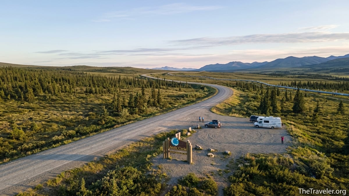
In Alaska, the Dalton Highway, a 414 mile road built to serve the Trans Alaska Pipeline, crosses the Arctic Circle at a signed wayside at about milepost 115. The Bureau of Land Management maintains the Arctic Circle Wayside here, a gravel parking lot with a large wooden sign, interpretive panels and basic facilities. Organized day tours from Fairbanks commonly drive north along the Elliott and Dalton Highways to this point, stopping at the Yukon River bridge on the way. These trips often include an “Arctic Circle Crossing Certificate” and commentary about life along the pipeline, and they spare visitors the challenge of driving a remote industrial road in a standard rental car.
On the other side of the world, Rovaniemi in Finland markets itself as the “Official Hometown of Santa Claus” and sits directly on the Arctic Circle. About 8 to 10 kilometers north of the city center, the Santa Claus Village complex straddles a marked Arctic Circle line, which runs through courtyards, souvenir shops and the main Santa office. Visitors can stand with one foot technically in the Arctic, pose with painted coordinates and, in winter, combine their visit with reindeer rides or Northern Lights excursions. It is one of the most commercialized and family friendly Arctic Circle crossing points, with hotels, restaurants and public buses from Rovaniemi railway station and airport.
Norway and Iceland offer smaller scale experiences. In northern Norway, the circle cuts across fjords and mountain plateaus; on some Hurtigruten and other coastal voyages, the crew marks the moment your ship crosses into the Arctic with a short ceremony on deck, often involving a playful ladle of icy water poured down your back. In Iceland, the circle does not touch the main island but passes through the offshore island of Grímsey, where visitors arriving by small ferry or domestic flight can follow a walking trail marked with stylized Arctic Circle spheres and signs. Each of these locations offers a very different feel: from coach park spectacle in Finland to quiet fishing island in Iceland.
Reading Arctic Circle Maps and On the Ground Markers
Before you go, it helps to understand how maps and signs represent the Arctic Circle so you can confirm you have genuinely reached it. Quality paper maps produced for road travel in Alaska, Lapland or Greenland almost always show the circle as a distinct horizontal band, typically labeled “Arctic Circle” or with its latitude figure. On many digital map apps you can add a graticule layer or enter the coordinates manually to see the circle as a drawn line over satellite imagery.
On the ground, the line is usually represented in ways that work in that specific landscape. At the Alaska Arctic Circle Wayside, the familiar brown and yellow highway sign shows a stylized globe with the circle picked out, while smaller interpretive panels explain the midnight sun and polar night. Stand behind the sign and you will likely find other travelers lining up to take the classic photograph. A handheld GPS or mapping app will show that the true circle is close by, though not always aligned perfectly with the sign, which was placed for practicality and visibility as much as mathematical accuracy.
At Santa Claus Village near Rovaniemi, the Arctic Circle is painted as a wide white line running through the complex, illuminated at night. Decorative markers around the village reinforce the idea that you are crossing into the Arctic region the moment you step over it. Locals are quick to point out that the strictly geodetic circle has shifted slightly north since the line was first laid, so the exact scientific latitude lies a bit closer to the airport, but for visitor purposes this clearly marked band is the accepted crossing point. Maps you find in local brochures and in the village itself show the line running right through the central plaza.
In wilder areas such as Greenland, the circle may not be marked at all. The long distance Arctic Circle Trail between Kangerlussuaq and Sisimiut runs just north of the latitude line for most of its 160 to 165 kilometer length, but you will not find a big gateway arch or tourist board sign at the exact crossing. Instead, hikers rely on topographic maps, GPS tracks and occasional cairns to navigate rugged tundra, lakes and low mountain passes. In this kind of environment, the understanding that you are in the Arctic comes from the landscape itself: dwarf birch and willow scrub, reindeer tracks in wet ground, and long, slow sunsets in late summer.
Planning a Visit: Routes, Seasons and Budget Examples
Your ideal Arctic Circle experience might look like a quick photo stop or a multi week expedition. The logistics, costs and best seasons vary sharply by region, so it helps to plan with concrete routes in mind. Many North American visitors start in Fairbanks, Alaska, where tour companies offer full day road trips to the Arctic Circle Wayside in summer, sometimes combining the outward or return leg with a scenic flight. These trips usually run from late May through early September, when daylight, road conditions and services are most favorable, and prices commonly sit in the mid three figure range per person once fuel and guiding are included.
Independent drivers considering the Dalton Highway need to budget for specialized vehicle rental or a robust personal vehicle, as many mainstream rental contracts prohibit travel on the Dalton. Fuel, extra tires, emergency supplies and a conservative driving style all matter more than on a normal road trip. Even if you only intend to reach the circle at milepost 115 and return to Fairbanks, you are looking at roughly a 400 mile round trip on a road with long stretches of no services, so it makes sense to factor in an overnight stop or flexible schedule in case of heavy rain, construction or truck traffic.
In Finland, Rovaniemi can be surprisingly straightforward to reach. Direct flights from major European hubs serve the city more frequently in winter, when Santa tourism and Northern Lights trips peak, but there are also overnight trains from Helsinki with sleeper cabins. Once in Rovaniemi, you can ride a local bus, arrange a quick taxi ride or join a short excursion to Santa Claus Village and its Arctic Circle line. The actual crossing moment is free, but spending the day there, with café stops, reindeer safaris or snowmobile tours, can easily turn into a full excursion budget. Travelers who hope to combine a symbolic circle crossing with more traditional Arctic landscapes often continue north to smaller Lapland villages such as Inari, Saariselkä or Kilpisjärvi.
For those drawn to quieter, more physically demanding experiences, Greenland’s Arctic Circle Trail offers a very different planning puzzle. Most hikers fly into Kangerlussuaq on pre booked flights, then spend 8 to 10 days walking west to Sisimiut. There are no road connections along the route, and only basic emergency huts and improvised campsites, so you must carry all your food and equipment and be comfortable with remote backcountry travel. Seasonal timing is critical: many hikers aim for late July and August, when rivers are generally fordable and snow cover is at its minimum, though even then you should be prepared for cold rain, wind and occasional frost.
What to Expect from Arctic Circle Weather and Daylight
One of the defining features of crossing the Arctic Circle is the shift in light. On the summer solstice around 21 June, everywhere on the circle experiences at least one full 24 hour period when the sun stays above the horizon. In places slightly north of the circle, this “midnight sun” period stretches on for weeks. In Rovaniemi, that means long dusky nights in early summer that feel more like late afternoon than midnight, while in coastal northern Norway and Alaska’s Brooks Range, the sun rolls slowly around the sky without fully setting, casting warm, low angle light on mountains, sea and tundra.
In winter, the opposite happens. You will still see some twilight at the latitude of the Arctic Circle itself, but the sun remains below the horizon for at least one full day, and further north the polar night extends into a long season of short blue hours and deep darkness. For travelers, this means your experience of the same place can be utterly different depending on the month. Visiting the Santa Claus Village in late December, for example, means arriving under a dark sky lit by fairy lights and snow reflections, while in June the same painted Arctic Circle line cuts through a sun washed plaza where children run around in T shirts at midnight.
Weather is equally variable and can change fast. Summer temperatures on accessible Arctic Circle locations can be surprisingly mild: around Rovaniemi and along parts of the Dalton Highway, daytime summer temperatures often sit in the low to mid teens Celsius, occasionally warmer, though rain and wind can make it feel colder. In Greenland’s interior, a warm spell can bring conditions that feel almost temperate by day but drop sharply at night. Winter brings deep cold, with temperatures commonly far below freezing, icy surfaces and the need for serious cold weather gear.
Because the Arctic Circle spans oceanic coasts, continental interiors and high plateaus, forecasts you read for one location will not necessarily apply to another. A traveler cruising past the circle near the northern coast of Norway might encounter drizzle and relatively mild temperatures thanks to the Gulf Stream, while someone the same week on the Greenlandic tundra could be dealing with dry, clear skies and hard frost. When planning, look up detailed, localized forecasts for your exact route and remember that strong winds or sudden snowfall can complicate travel even outside the depths of winter.
Practical Safety and Cultural Considerations
Standing on the Arctic Circle is a powerful travel moment, but it is still a real place with real risks and communities, not a theme park boundary. On the Dalton Highway, tourists share the road with long haul trucks serving remote oil fields. Respecting the road as a working industrial route is essential: pull well off the gravel when stopping near the Arctic Circle sign, keep headlights on for visibility, and be patient when large vehicles need to pass. Cell coverage is sporadic, so many visitors carry paper maps and let someone in Fairbanks know their route plan and expected return time before heading north.
In Lapland and Greenland, you move through Sámi and Inuit homelands, where reindeer herding and hunting have been part of the landscape for centuries. When maps and visitor brochures highlight the Arctic Circle, they sometimes gloss over these deeper connections. As a traveler, you can show respect by staying on established trails, giving wide berth to working reindeer herds or sled dog teams, and favoring locally owned operators when booking excursions. Museums and cultural centers in Rovaniemi, Kangerlussuaq and Sisimiut, among others, provide context on how Indigenous communities have navigated Arctic seasons long before visitors arrived with cameras.
Environmental conditions also require thoughtful preparation. Even on a fine summer day, the stretch of Dalton Highway around the Arctic Circle has few services, and vehicles do occasionally suffer punctures or mechanical problems on the rough surface. Carrying extra water, food, a full size spare tire and basic tools is sensible. On hiking routes like the Arctic Circle Trail, self sufficiency steps up another level: water purification, shelter, navigation tools and first aid skills all matter, as you may go days without meeting another person. Tour operators and official visitor centers in each region are good sources of current advice on hazards such as river levels, wildfire smoke or wildlife activity.
Traveling responsibly in the Arctic region also means being realistic about your own experience level. A short guided excursion to the Arctic Circle sign from Fairbanks, or a half day at Santa Claus Village, is suitable for most reasonably mobile travelers. A solo crossing of Greenland’s Arctic Circle Trail or a winter drive toward the Brooks Range is a very different undertaking that demands training, equipment and contingency planning. Using maps and guidebooks not just to locate the circle but to understand terrain and infrastructure will help you choose the version of the Arctic that fits you best.
The Takeaway
The Arctic Circle is more than a line on a globe. It threads together Alaskan highways, Finnish family attractions, remote Greenlandic valleys and Norwegian and Icelandic seas. On maps it has a single latitude, but on the ground it looks like painted stripes on tarmac, lonely roadside signs and unnamed ridgelines with no markers at all. The moment you step across it will feel very different depending on whether you are wrapped in a park visitor center fleece, a heavy expedition parka or a pair of light summer hiking pants at midnight.
By taking time to study Arctic Circle maps, choose an appropriate crossing point and season, and prepare for the realities of northern weather and remoteness, you can turn a simple photo opportunity into a deeper encounter with the high latitudes. Whether you celebrate with a certificate on Alaska’s Dalton Highway, a family snapshot at Santa Claus Village or a quiet pause on Greenland’s long distance trail, you will carry home more than a checked box. You will have a clearer sense of how this invisible line shapes daylight, climate and culture at the very top of the world.
FAQ
Q1. Where exactly is the Arctic Circle located?
The Arctic Circle is a line of latitude currently near 66.5 degrees north, circling the globe through parts of Alaska, Canada, Greenland, Iceland, Norway, Sweden, Finland and Russia.
Q2. Can I drive to the Arctic Circle?
Yes. One of the most popular drive up locations is the Arctic Circle Wayside on Alaska’s Dalton Highway, a signed pullout roughly 115 miles along the road from its junction with the Elliott Highway.
Q3. What is the easiest place to visit the Arctic Circle in Europe?
For many travelers the easiest European access is Rovaniemi in Finnish Lapland, where local buses and tours run to Santa Claus Village and its clearly marked Arctic Circle line just north of the city.
Q4. Do I need special equipment to visit the Arctic Circle?
For short, guided visits in summer, normal outdoor clothing and layers are usually enough. For winter trips or backcountry routes like the Arctic Circle Trail in Greenland, you need serious cold weather gear and wilderness equipment.
Q5. When is the best time of year to cross the Arctic Circle?
Summer offers easier travel, open roads and the midnight sun, roughly from June to August. Winter provides snow, polar night conditions and Northern Lights opportunities but demands more preparation and flexibility.
Q6. Will I see polar bears when I visit the Arctic Circle?
Most easily accessible Arctic Circle locations, such as Rovaniemi and the Alaska highway crossing, are not typical polar bear habitats. Encounters are rare there but more possible in some coastal Arctic regions further north.
Q7. Do I get a certificate for crossing the Arctic Circle?
Some tour operators and visitor centers offer certificates, especially on organized trips from Fairbanks to the Alaska crossing and on certain excursions in Lapland. Independent travelers will usually just document the moment with photographs.
Q8. How long should I plan for an Arctic Circle trip?
A basic visit to a road accessible marker can be done in a long day from a nearby hub city. If you plan to combine your crossing with hiking, coastal cruising or multiple Arctic towns, allow at least several days to a couple of weeks.
Q9. Is visiting the Arctic Circle suitable for families with children?
Yes, particularly in developed locations such as Santa Claus Village near Rovaniemi, which is designed around family visits. Parents should still plan for cooler temperatures, variable weather and travel times appropriate to their children’s ages.
Q10. How can I travel responsibly in Arctic Circle regions?
Use local guides and operators, respect Indigenous cultures and livelihoods, follow Leave No Trace principles outdoors, and prepare thoroughly so you do not put unnecessary strain on limited local emergency services.