


Naguabo wears its nickname proudly. El Pueblo de los Enchumbaos, loosely “the town of the soaked,” hints at how central rain is to life on this lush corner of Puerto Rico’s east coast. For visitors, that nickname is also a planning tool. In Naguabo, the most important decision is not just how hot it will be, but how wet, how fast local rivers are rising, and whether upstream storms in the Luquillo Mountains are turning otherwise calm swimming holes into dangerous torrents.
Get the latest updates straight to your inbox!
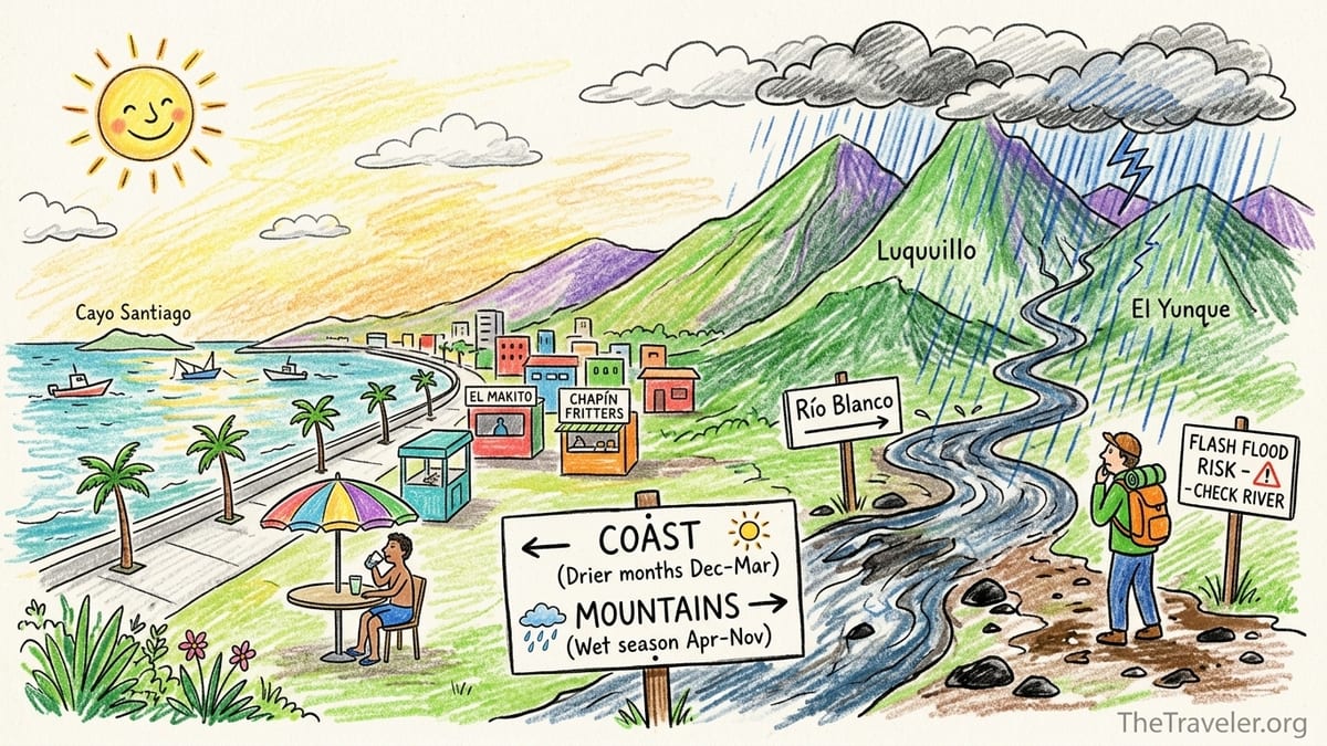
Understanding Naguabo’s Climate, Rainfall and Seasons
Naguabo sits on Puerto Rico’s eastern coastal plain, facing the Vieques Passage and backed by the Luquillo Mountains and El Yunque National Forest. That geography matters. Trade winds from the Atlantic hit the mountains, rise, and dump moisture, which is why nearby El Yunque records some of the highest annual rainfall on the island. Naguabo itself is warm year-round, with daytime highs commonly around the upper 80s Fahrenheit along the coast, but what changes month to month is the pattern and intensity of rain rather than the temperature.
Climatology data for Naguabo shows a wetter stretch from about April through November, with a noticeable rainfall peak in late summer and early fall, especially around September. During this time, afternoon and evening showers and thunderstorms are common, and some days bring long, soaking rain focused on the mountain slopes. The drier months from roughly December to March still see showers, but they tend to be shorter and less intense, which generally makes it easier to plan full days outdoors.
Puerto Rico’s Atlantic hurricane season officially runs from June 1 to November 30, with historical activity and rainfall impacts often concentrating from August through October. While a direct hurricane hit on any given trip is relatively unlikely, tropical storms, outer rainbands and tropical waves can drop intense rain on short notice. For Naguabo, that means that even in stretches of sunny weather, you should treat the wet and hurricane seasons as periods when river trips need a backup plan and daily weather checks are non-negotiable.
Because the mountains sit directly behind town, Naguabo’s rainfall pattern differs from drier parts of Puerto Rico. You can experience perfectly bright skies at the Malecón while watching thick clouds pile up over Pico del Este. That contrast is one of the area’s main attractions, but it is also the reason local tourism agencies and the National Weather Service advise checking weather and river conditions before swimming or hiking in river canyons near Naguabo.
Coastal Naguabo vs Rivers and Rainforest: Different Weather Realities
For trip planning, it helps to divide Naguabo into two worlds. On the coast, areas like the Malecón de Naguabo at Playa Húcares function almost like a small seaside town: mostly flat, breezy, and easy to enjoy even if passing showers move through. Inland and upslope, the picture changes quickly. The foothills and lower rainforest catch more frequent and heavier rain, feeding short, steep rivers that can rise and fall in a matter of minutes.
The Malecón itself is a compact waterfront promenade with rows of seafood kiosks and restaurants facing the bay. Local and national tourism sources describe it as one of the island’s better-known seafront strips, famous for chapín (boxfish) fritters, whole fried fish and weekend family outings. On a wet afternoon, you might get brief downpours that send people under awnings for twenty minutes, then everyone moves back to the railings to watch small fishing boats and the outline of Cayo Santiago offshore once the sun comes back out. Rain affects comfort and views, but it rarely creates a safety problem on the pavement.
By contrast, river access points and mountain trails are directly tied to runoff. Creeks that look like gentle cascades in photos can transform rapidly if a thunderstorm forms over the Luquillo ridge. This is especially relevant around the interior barrios that drain into rivers such as Río Blanco and others flowing from the high slopes between Naguabo and neighboring Ceiba. Even when those upper valleys are mostly forest and farmland, they funnel water straight down narrow channels with limited escape options for swimmers and hikers.
The result is that a gray, drizzly morning at the Malecón might be nothing more than an excuse for a longer lunch, but the same morning can render upstream river crossings unsafe. Understanding this split between “coast weather” and “mountain weather” is key to deciding when to proceed with a planned river swim or forest hike and when to pivot to food and sightseeing along the waterfront instead.
How Flash-Flood Guidance Applies in Naguabo’s Rivers
The National Weather Service issues regular flash-flood guidance and watches for Puerto Rico, using data from rain gauges, radar and river sensors to estimate how much additional rain would trigger flooding in specific basins. Maps produced by the Southeast River Forecast Center highlight how quickly small, steep watersheds in eastern Puerto Rico can reach dangerous levels. In these basins, even 1 to 3 inches of intense rain in an hour over the mountains can be enough to push a stream from normal to flood stage.
For a visitor in Naguabo, this means that what matters is not only what you see overhead but also what has been falling upriver. You might arrive at a swimming hole in a lower valley, see cloudy but calm water and light drizzle, and assume it is safe. Yet if strong thunderstorms have spent the past hour parked over the high ridges of El Yunque and its neighboring peaks, water could be racing toward you in the channel, hidden by bends and boulders until the surge arrives. The National Weather Service has documented severe flash-flood events in Puerto Rico where short, steep rivers rose feet within minutes after heavy mountain rainfall, leaving people little time to react.
Checking the daily forecast, radar imagery and any active flash-flood alerts is therefore essential before a river or rainforest day. If the weather discussion highlights a high risk of heavy rain for the eastern interior or if flash-flood watches include Naguabo’s mountain watersheds, the safest option is to avoid river swimming and canyon hikes altogether. Even when no watches are in effect, recent rainfall matters. Guidance products are built around soil saturation; after days of showers, it takes less new rain for runoff to spike, which is why local emergency managers often stress avoiding rivers for several days after a major storm or tropical system.
In practical terms, treat rivers in and around Naguabo with the same caution you would give whitewater anywhere: never assume that clear skies at the coast equal safe conditions inland, do not enter narrow gorges or climb onto mid-channel rocks if clouds are stacking up over the mountains, and be prepared to abandon river plans entirely on days when the National Weather Service calls for strong thunderstorms focused on the Luquillo range.
Heat, Midday Sun and Crowds on the Malecón and Playa Húcares
While rainfall and river safety are the primary concerns inland, coastal visitors need to think more about heat, sun exposure and crowds. Along the Malecón and Playa Húcares, afternoon temperatures often feel hotter than the actual reading because of humidity and reflected sun off the pavement and sea. From roughly late May through October, “feels like” temperatures at mid-afternoon can climb into the mid 90s Fahrenheit or higher, especially on still days. Combined with Caribbean sun angles, that makes midday strolling uncomfortable for many travelers.
In practice, this shapes the daily rhythm of the Malecón. Many restaurants open around midday, but peak activity along the waterfront often comes in the late afternoon and early evening, when the sun drops, breezes strengthen, and locals arrive for seafood dinners and drinks. Visitor reports and tourism write-ups consistently note that weekends are the busiest time, when local families from Naguabo, Humacao and other nearby towns drive in for lunch at well-known spots such as El Makito or to sample pastelillos de chapín from simple kiosks along the strip. Weekday afternoons, by contrast, can feel almost sleepy, with some kiosks closed and easy street parking.
If you are sensitive to heat, plan Malecón strolls and coastal walks either before 10 a.m. or after 4 p.m. During the hottest part of the day, it is more comfortable to sit at a shaded table with fans and cold drinks than to be walking the exposed seawall. Some visitors time their arrival at Playa Húcares for about an hour before sunset, combining a cooler-temperature walk with dinner as the sky colors over the bay. On especially humid days, even short walks can leave you drenched, which fits Naguabo’s “enchumbao” identity but may not be how you want to spend every afternoon.
Weekends bring not only more people but also more cars and louder sound systems. For some, that is part of the appeal: a lively, working-class local scene centered around fried fish, beer and salsa or merengue drifting from bar speakers. For others, especially those looking for quiet coastal photography or leisurely, introspective walks, it can be overwhelming. If you want the food but not the crowds, consider visiting on a weekday evening outside of local holiday periods, when key restaurants are open but the promenade feels less packed.
Wet Season, Hurricane Season and When to Change Plans
Naguabo’s wet season and hurricane season overlap but are not identical. The wet season, roughly April through November, brings frequent showers and thunderstorms even on otherwise nice days. Travel during this time can still be rewarding, especially for visitors who do not mind rain-cooled afternoons or moody mountain views. However, it requires flexible day-to-day planning. A morning that looks fine for a waterfall hike can turn into a late-morning thunderstorm window with little warning, particularly in May, June and again from late August into October.
Hurricane season adds another layer, mainly from August to October, when tropical waves, depressions and storms are most common in the wider Caribbean. Even when Naguabo is far from the center of a system, outer bands can bring very heavy rain for many hours. During these periods, river trips should generally be off the table for several days, both due to the immediate risk of flash flooding and the lingering effects of saturated soils, downed branches and slippery rocks. El Yunque, for example, sometimes closes specific trails or entire sectors after significant storms, and similar caution applies to informal river access points around Naguabo.
The key skill for visitors is knowing when to pivot. If the morning National Weather Service discussion highlights a strong disturbance approaching or mentions a high risk of flash flooding for the east interior, reframe your day as a coastal or town-focused outing instead of a nature immersion. Rather than pushing ahead with plans to climb higher into the rainforest or explore narrow river canyons, make a slow lunch at the Malecón your centerpiece, add a visit to Naguabo’s central plaza or nearby viewpoints accessible by road, and keep any water time to shallow, lifeguarded coastal areas if those are open.
During the drier season, from late December through March, it becomes easier to commit to outdoor plans a day or two in advance. Heavy, all-day rain events are less frequent, and atmospheric patterns favor more stable conditions. This is often when local businesses describe being in “high season,” not only because of visiting travelers from colder climates, but also because coastal driving and hiking feel more predictable. Still, isolated showers can form at any time in a tropical climate. The safest mindset is to treat dry-season forecasts as guidance for comfort, not a green light to ignore river and flood advisories when they are issued.
Best Months by Activity: Malecón, Rivers, Rainforest Hikes and Mixed Days
For Malecón and food-focused trips, the sweet spot is generally from December through April. Rainfall is somewhat lower, humidity slightly more manageable, and the chances of hurricanes or extended tropical downpours are reduced. During these months, you can often plan late-afternoon or evening seafood meals at Playa Húcares with a reasonable expectation of comfortable conditions, though short showers can still pass through. High tourist demand across Puerto Rico at this time may make popular restaurants busier, so visiting on weekdays or slightly outside major holidays helps keep waits manageable.
River swimming and waterfall outings are most appealing when rain has been modest for several days, regardless of month. Practically, that often means favoring late winter and early spring windows, or dry stretches within the broader wet season. For example, if you arrive in early March and find that the previous week’s forecasts have featured sun with only isolated showers, you are more likely to encounter clear, moderate rivers at lower elevations. By contrast, late September, which climatology indicates as one of the rainier months in Naguabo, is far more likely to bring high, murky water and occasional flood advisories, making river play a lower-probability activity.
Lower-elevation rainforest and foothill hikes just inland of Naguabo are feasible year-round with proper gear, but comfort and safety improve outside the heart of the wet and hurricane seasons. From January through March, trails might still be muddy but are less likely to be overwhelmed by continuous downpours. Visibility toward the coast also tends to be better between passing showers. Daytime highs remain warm but slightly less oppressive than in late summer, which matters on sustained climbs. Whenever you hike near rivers, build in escape margins: start early, watch clouds over El Yunque, and turn back if thunder develops.
Mixed day trips that combine coast and mountains require the most flexibility, especially from April through November. A smart approach in these months is to front-load the mountain portion, leaving the Malecón as the “Plan B” afternoon. Begin with an early-morning forest walk or scenic drive inland, keeping a close eye on radar and short-term forecasts. If storms begin to fire over the mountains by late morning, abandon any ideas of river swimming or higher ridges and head back to the coast for a shaded lunch and seaside stroll. This way, the inevitable afternoon showers become part of the atmosphere rather than a trip-ruining surprise.
When to Swap River or Rainforest Plans for Food and Sightseeing
One of the advantages of basing yourself in or near Naguabo is how easy it is to change course without losing the day. If conditions make rivers or rainforest hikes questionable, you are rarely more than a 20 to 30 minute drive from the Malecón, Playa Húcares and other low-risk activities. The challenge is recognizing early enough that a swap is warranted, rather than pressing on into deteriorating conditions inland.
You should seriously consider abandoning river and upper-forest plans if any of the following apply: a flash-flood watch or warning covers eastern Puerto Rico; the morning radar shows large, persistent clusters of storms over the Luquillo Mountains; recent reports mention rivers already running high or discolored; or strong thunderstorms are forecast to peak over the interior during the hours you would be in narrow canyons. In these scenarios, the safest choice is to keep your feet on concrete and your eyes on the sea, not to “just take a look” upriver.
On such days, the Malecón’s restaurants and kiosks virtually become your backup itinerary. You might spend extra time trying different pastelillos, exploring side streets, or watching fishing boats unload their catch. If rain is widespread but not severe, you can make a slow loop by car along the eastern coast, pausing at viewpoints and small urban beaches when showers lighten. For many travelers, these improvised “rain days” end up being unexpected highlights: more conversations with locals, longer meals, and a better feel for daily life in Naguabo than a rushed hike would provide.
If you are staying for several days, it pays to mentally assign each morning as either a “high-risk” or “low-risk” slot for inland excursions based on forecasts. Use low-risk mornings for any must-do nature plans. Reserve high-risk mornings for activities that can move under a roof at a moment’s notice. A detailed plan might read: “If rain chances spike inland, brunch and coffee at the Malecón; if the radar looks clean, waterfall first, then return to town by lunch.” That style of planning suits Naguabo’s soaked identity and respects the reality that water shapes what is possible every day.
The Takeaway
In Naguabo, the best time to visit depends less on thermometer readings and more on how comfortable you are dancing with rain. Coastal visitors focused on seafood, sunsets and casual strolls along the Malecón will find the most consistently pleasant experience from December through April, when rainfall is somewhat reduced, hurricane risk is lower, and afternoon heat is still manageable with a breeze. Weekend crowds at Playa Húcares add energy and music; midweek evenings offer the same seafood with more elbow room.
Travelers drawn to rivers and rainforest should be more selective. Aim for windows when forecasts show several days of moderate or light showers rather than continuous downpours, and treat late summer and early fall with extra caution due to heavier rains and tropical systems. Always check National Weather Service products for flash-flood watches and radar trends over the Luquillo Mountains before committing to river swimming or canyon hikes, and do not hesitate to abort inland plans if warnings are issued or storms are clearly building over the ridges.
For mixed itineraries that combine coast, rivers and forest, flexibility is your greatest asset. Start early inland, be ready to turn back at the first signs of thunder or rising water, and treat the Malecón as your default backup for rainy afternoons. In El Pueblo de los Enchumbaos, planning “around the water” rather than “despite the water” is what turns a good trip into a great one.
FAQ
Q1: What is the best month to visit Naguabo for generally dry weather?
January through March usually bring somewhat lower rainfall and fewer long-lasting storms, which makes them the most reliable months for comfortable coastal visits and flexible day trips.
Q2: Is it safe to visit Naguabo’s rivers during the wet season?
It can be, but only when recent rain has been modest and no flash-flood watches or warnings are in effect. Always check National Weather Service advisories and avoid rivers if heavy rain has fallen upstream or strong storms are in the forecast.
Q3: How does rain in El Yunque affect river safety near Naguabo?
El Yunque and the Luquillo Mountains act like a catchment. Intense rain there can send sudden surges of water down into rivers that reach Naguabo, even if it is only drizzling or briefly sunny at the coast.
Q4: Are weekend crowds at the Malecón a reason to avoid visiting then?
Not necessarily. Weekends are busier, with more families, louder music and longer waits at popular seafood spots, but many visitors enjoy the lively atmosphere. If you prefer quieter conditions, go on weekday evenings instead.
Q5: What time of day is best for walking the Malecón in hot months?
Mornings before about 10 a.m. and late afternoons after roughly 4 p.m. are usually more comfortable. Midday can feel very hot and humid, so plan to be in shade or seated at that time.
Q6: Should I cancel a rainforest hike if the forecast shows a chance of showers?
A simple “chance of showers” is normal in a tropical climate. What should trigger cancellation is a forecast or advisory mentioning heavy rain, thunderstorms focused on the interior, or flash-flood risk for eastern Puerto Rico.
Q7: How many days after a tropical storm should I wait before swimming in rivers?
Local authorities often recommend staying out of rivers for several days after major storms because of high, fast-moving water and debris. Check local guidance and, if in doubt, choose coastal or town activities instead.
Q8: Are coastal waters at Playa Húcares affected by river flooding?
Yes, heavy river runoff can make nearshore water murkier and bring debris after big rain events. Conditions vary by day, so use visual judgment on arrival and follow any local safety notices.
Q9: Do restaurants on the Malecón close in bad weather?
Most established restaurants remain open during rain, especially on weekends and in high season, although outdoor seating may be limited. Very severe weather, such as a nearby tropical storm, can lead to temporary closures.
Q10: If I have only one full day in Naguabo, how should I plan it?
Check the forecast early. If inland conditions look stable, start with a morning forest or river outing and move to the Malecón for a late lunch and sunset. If rain risk inland is high, stay coastal, explore the promenade and nearby viewpoints, and treat rivers as a future-trip goal.