
Stand on a working crab dock at dawn in Crisfield, pedal a misty rail trail outside Cumberland by afternoon, and you begin to understand Maryland. The state that markets itself as “America in Miniature” is not just a slogan. Within a few hours’ drive, travelers can move from tidal marsh to maritime main street, then climb into cool Appalachian ridges. Blue crabs, bay towns and mountains do not just decorate Maryland’s postcards; together they form the spine of its culture, cuisine and sense of place.
Get the latest updates straight to your inbox!
The Chesapeake Bay: Maryland’s Salty Center of Gravity
Look at a map of Maryland and the Chesapeake Bay almost cuts the state in two. On the ground, it feels less like a divide and more like a wide, tidal main street. Towns such as Annapolis, Cambridge and Solomons line up along its edges, their rhythms shaped by the tide tables as much as the morning commute. Boat masts frame the skyline, bait freezers hum behind waterfront gas stations, and roadside stands sell soft-shell crabs in spring the way others sell strawberries.
For visitors, the Bay is often the first encounter with Maryland’s identity. In Annapolis, the state capital, the brick-lined streets of the Historic District slip downhill to ego alley, the narrow harbor where pleasure boats parade in front of old oyster warehouses. Just 40 minutes by car from Baltimore-Washington International Airport, you can be eating a crab cake on an outdoor deck while watching midshipmen in dress whites cross to the U.S. Naval Academy. On a summer weekend, harbor tours and sailing lessons circle the same waters that once carried British warships and Chesapeake watermen.
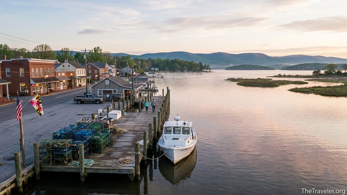
Farther south, the working waterfront of Solomons tells a quieter Bay story. Here, skipjacks and small deadrise workboats tie up beside open-air seafood shacks. Late afternoon often brings a mix of charter fishing crews cleaning striped bass on the dock, families sharing fries at picnic tables and kayak groups sliding into the Patuxent River from public launches. It is in places like this, where the Bay feels like both a highway and a pantry, that travelers sense how deeply the water defines daily life.
Blue Crabs and the Ritual of Maryland Eating
Few foods are as tied to place as the Chesapeake blue crab. In Maryland, crabs are less a menu item and more a seasonal ritual. From late spring through early fall, bushel baskets arrive at docks in small towns like Crisfield and Tilghman Island, and hand-lettered signs outside taverns and VFW halls announce “All You Can Eat Crabs” evenings that can stretch for hours. For visitors unfamiliar with the process, the sight of brown paper–covered tables piled high with steamed crabs and mallets can feel like initiation into a local secret society.
Learning to eat crabs the Maryland way is part of the experience. A server might drop a dozen bright-red crabs in the middle of the table along with Dixie cups of melted butter, bottles of vinegar and a plastic shaker of Old Bay–style seasoning. Locals show newcomers how to twist off claws, crack the apron and clean out the backfin meat. It is messy, slow food. A family of four might spend two hours picking through a single order, talking across the table as the pile of shells grows. In coastal towns in summer, it is common to see picnic tables covered in red shells stacked outside seafood houses by closing time.
Crab culture extends beyond the picking tables. In Baltimore’s Lexington Market and neighborhood crab houses from Essex to Glen Burnie, crab cakes serve as a kind of identity test. Marylanders debate which spot uses mostly backfin meat, who adds just enough binder and which places serve them broiled instead of fried. At roadside stands on the Eastern Shore, soft-shell crab sandwiches appear when molting season peaks, typically costing only a little more than a burger from a national chain but tasting distinctly of the Bay. Even in Western Maryland, hours from tidewater, supermarket cases and bar menus proudly label “Maryland-style crab soup” alongside local brews.
Bay Towns: From Maritime Main Streets to Island Edges
The small towns that dot Maryland’s shoreline give the state much of its character. Each pairs a distinct waterfront setting with a walkable main street, making them ideal bases for travelers who prefer sidewalks to resort strips. St. Michaels on the Miles River, for instance, mixes historic homes and the Chesapeake Bay Maritime Museum with boutiques, inns and oyster bars. On a fall weekday, you might see school groups boarding skipjack replicas for on-the-water lessons while couples rent bikes to ride out past farm fields and colonial churches.
On the lower Eastern Shore, Crisfield presents a grittier, more workaday version of a Bay town. Known as the “Crab Capital of the World,” it still wakes up to the sound of engines on small commercial boats heading into Tangier Sound. The city’s harbor doubles as a departure point for ferries to Smith Island, an isolated community where the accent, Methodist churches and multi-layered Smith Island cakes feel preserved from another era. A visitor catching the morning ferry can spend a day walking the narrow lanes of Ewell, eating crab-topped hush puppies at a local restaurant, then return to Crisfield in time for sunset over the peeling-paint crab shacks.
Even where industry has faded, the water clamps town and landscape together. In Cambridge on the Choptank River, murals of watermen line brick walls near the harbor, where modern sculpture walks and boutique hotels share space with seafood dealers and charter fishing boats. A casual dinner might mean crab dip at a renovated warehouse restaurant overlooking the drawbridge, followed by a stroll past restored skipjacks in the harbor berm. These towns are living communities first and tourist destinations second, and that authenticity is often what appeals most to travelers.
Ocean Edge: Assateague, Boardwalks and the Open Atlantic
Maryland’s identity is not only about the sheltered waters of the Chesapeake. To the east, barrier islands and beach towns open onto the Atlantic, adding surf culture and sandy nostalgia to the state’s personality. Assateague Island, a 37-mile-long barrier island along the coasts of Maryland and Virginia, offers the wildest version of this ocean edge. On the Maryland side, Assateague State Park and the adjacent national seashore protect windswept dunes, salt marshes and a narrow strip of oceanfront that is the state’s only official oceanfront park. Visitors drive over a short causeway from the mainland and within minutes trade strip malls for sea oats and the possibility of spotting feral horses picking through the dune grass.
Assateague feels especially distinctive in the shoulder seasons. In April or October, a midweek camper might wake to the sound of waves and wind rattling tent lines, then walk down to a nearly empty beach. The water can be brisk, but surf anglers in waders still cast for bluefish and striped bass. Kayakers and paddleboarders often prefer the bay side, where shallow coves hold herons, egrets and schools of small fish. Interpretive programs offered by rangers and Maryland Conservation Corps staff help visitors understand how barrier islands shift under the combined forces of storms, tides and development pressure.
Just across the inlet, Ocean City presents an entirely different coastal mood. Its three-mile wooden boardwalk, lined with arcades, fries stands and neon-lit ride piers, channels a classic Mid-Atlantic beach-town energy. A summer visitor might spend the day on a guarded beach, rent boogie boards from a stand on the sand, then ride a Ferris wheel at dusk as lights come up over the hotels. For many families from Baltimore, Washington and Pennsylvania, Ocean City is their first memory of Maryland, as central to their idea of the state as blue crabs or football games.
Mountains and Rail Trails: A Different Maryland in the West
Drive three hours west from Annapolis and the terrain shifts in stages from rolling Piedmont farms to the folded ridges of the Appalachians. Here, in Washington, Allegany and Garrett counties, Maryland trades tidal marsh for mountain laurel, and the culture leans more toward hunting cabins and rail beds than sailboats and crab pots. For many first-time visitors, the transition is startling. Passing through the narrow rock walls of the Cumberland Narrows on Interstate 68, with sandstone cliffs on one side and a rail line on the other, it can be hard to reconcile this landscape with the flat horizons of the Eastern Shore.
Cumberland itself serves as a hinge between Maryland’s watery east and rugged west. Once a major coal and rail hub, it now markets itself as a trail town. Canal Place, the city’s heritage park, marks the western terminus of the Chesapeake and Ohio Canal National Historical Park’s 184.5-mile towpath and the eastern terminus of the Great Allegheny Passage rail trail. Cyclists arriving from Washington, D.C., wheel their loaded bikes past a preserved canal boat and interpretive exhibits, then continue uphill toward the Mason-Dixon Line and Pittsburgh. Others base themselves in one of several downtown hotels or B&Bs and ride day trips on crushed-stone paths that follow former rail lines through forested valleys.
Beyond Cumberland, Western Maryland’s mountains add more outdoor dimensions. Rocky Gap State Park pairs a sandy lakeside beach with short summit hikes; in summer, families switch between paddling rentals and shaded trails within a single afternoon. Farther west, Deep Creek Lake and Wisp Resort offer boating, zip lines and skiing, depending on the season. Even in the warmest months, temperatures can run several degrees cooler than on the Bay, and evening campfire weather often arrives by late August. This highland Maryland feels culturally closer to nearby West Virginia and western Pennsylvania, yet road signs pointing back to Annapolis and the Eastern Shore are a constant reminder that it shares a state outline with blue crab docks and barrier islands.
Canals, Railroads and the Story of Movement
To understand what truly defines Maryland, it helps to see not just where people live but how they have moved across the landscape. The Chesapeake and Ohio Canal, begun in the early nineteenth century, once linked Georgetown in Washington, D.C., with Cumberland along a 184.5-mile corridor beside the Potomac River. Today, its towpath has been reborn as a long-distance trail, allowing walkers and cyclists to trace the same route that mules once followed towing canal boats. In places like Hancock, Williamsport and Brunswick, the trail cuts right behind old brick warehouses and canal-era homes, pulling travelers directly into the fabric of canal towns.
Modern visitors experience this history in very practical ways. A bikepacker riding from Harpers Ferry to Cumberland might plan daily mileage around hiker-biker campsites spaced every few miles along the C&O Canal, where basic clearings, picnic tables and water pumps replace hotels. Small towns near convenient access points, such as Shepherdstown just across the river in West Virginia or Hancock along the Western Maryland Rail Trail, tend to support bike-friendly inns, diners serving hearty breakfasts and shops that stock spare tubes next to fishing gear. A single four-day trip can stitch together over a dozen communities, giving travelers a cross-section of Maryland’s inland culture that few highway drivers ever see.
Rail history is even more visible in Western Maryland, where the Western Maryland Scenic Railroad runs excursion trains from Cumberland to Frostburg. In the Narrows, trains pass under rock outcrops that once guided Native travel corridors, wagon roads and eventually highways. The layered infrastructure tells a story of a state that has always been about movement: of goods from coal mines to ports, of people from farm to city, and now of travelers seeking slower routes along old industrial lines.
How These Landscapes Shape Maryland Culture
Because Maryland’s regions are so different and so close together, residents often grow up crossing them without much ceremony. A weekend might involve driving from suburban Columbia to a lacrosse tournament near Frederick in the morning, then continuing west to a campsite near Greenbrier State Park by evening. Another weekend could swap that for a day trip to the Eastern Shore, with a stop for cream-of-crab soup in Kent Narrows on the way to a rented kayak launch near Queenstown. For visitors, this easy layering of inland and coastal experiences is part of the appeal.
The result is a culture that mixes maritime practicality with Appalachian resourcefulness and suburban corridor energy. In one conversation you might hear debates about the best way to steam crabs, in the next a discussion about the condition of the C&O towpath after a wet spring, and then an argument over which exit off the Capital Beltway reaches a particular shopping center fastest. Festivals reflect this blend: waterfront crab feasts in counties like Calvert and Dorchester, fall foliage celebrations and heritage rail events in Allegany and Garrett, and multicultural street fairs in Silver Spring or Hyattsville that draw on global immigrant communities.
For travelers, understanding this cultural blend can shape how they plan a trip. Instead of treating Maryland as a day-trip side note to Washington or Philadelphia, it can be framed as a compact road trip of its own: two days tracing the Bay through Annapolis and St. Michaels, a day or two tracing the canal through Brunswick and Williamsport, and another set of days in Cumberland and Deep Creek. In each region, choosing locally owned inns, family-run crab houses or long-standing diners connects you more directly to how residents navigate life in a state that shifts under their feet with almost every hour of driving.
The Takeaway
In the end, what defines Maryland is not a single iconic landmark but the way multiple landscapes overlap and inform one another. Blue crabs tie working docks on the lower Eastern Shore to white-tablecloth restaurants in Bethesda. Bay towns that once launched oyster dredges now welcome kayaks and weekend sailors alongside commercial boats. Mountains that carried coal trains now host cyclists and hikers exploring rail trails and state parks. The C&O Canal and Great Allegheny Passage link tidal flats and ridge tops in one continuous story of movement.
For travelers, this means Maryland rewards curiosity and cross-regional itineraries. A trip framed only as a beach weekend or a historic-city stop risks missing the state’s deeper character. Follow the path of the crabs from live tanks to newspaper-covered tables, trace the canal towpath from capital city to mountain town, and drive far enough west that Bay breezes give way to cooler mountain air. Somewhere along that route, often where the landscapes overlap, Maryland stops being a slogan and becomes a place with its own layered, lasting identity.
FAQ
Q1. When is the best time of year to visit Maryland for blue crabs?
Peak crab season typically runs from late May through early October, with the warmest months offering the widest availability at waterfront crab houses and festivals.
Q2. Where can I experience a classic Maryland crab feast as a visitor?
Look for crab houses in waterfront towns such as Annapolis, St. Michaels, Kent Narrows, Crisfield and along Baltimore’s eastern suburbs, where paper-covered tables and steamed crabs are standard.
Q3. Are Maryland’s small Bay towns easy to visit without a car?
Annapolis and some larger towns offer limited transit and rideshare options, but reaching smaller places like Tilghman Island, Crisfield or Smith Island generally requires driving or joining an organized tour.
Q4. What should I know before visiting Assateague Island?
Expect limited services compared with nearby resort towns, be prepared for insects in warmer months, secure food from wildlife and check current park conditions and any swim or safety advisories.
Q5. How different is Western Maryland from the Chesapeake region?
Western Maryland is hillier and cooler, with a focus on rail trails, hiking, lakes and ski areas, while the Chesapeake region centers on boating, seafood and tidal landscapes.
Q6. Can I connect a Chesapeake Bay trip with a mountains visit in one itinerary?
Yes. Many travelers spend a couple of days in Annapolis or on the Eastern Shore, then drive three to four hours to Cumberland or Deep Creek Lake for hiking, biking and cooler air.
Q7. Is the C&O Canal towpath suitable for beginner cyclists?
The towpath is mostly flat and traffic-free, making it approachable for beginners, though surfaces can be muddy or rough in spots, so wider tires and a relaxed pace are helpful.
Q8. Do I need a permit to camp along the C&O Canal?
Drive-in campgrounds may require reservations, while many hiker-biker sites along the towpath are first-come with simple rules and limits on how close you can camp to towns or roads.
Q9. Are Maryland’s waterfront towns very crowded in summer?
Popular spots like Annapolis, Ocean City and St. Michaels can be busy on summer weekends, so consider weekday visits or shoulder seasons in spring and fall for lighter crowds.
Q10. What is a realistic budget for eating seafood in Maryland?
Prices vary by location and season, but visitors can expect casual crab houses to charge a moderate premium over standard pub fare, with market prices for steamed crabs posted daily.