
Newfound Gap Road is often described as a pretty way to get from Gatlinburg, Tennessee, to Cherokee, North Carolina. That description is technically accurate and wildly incomplete. This 31-mile stretch of US 441 is the backbone of Great Smoky Mountains National Park, a ribbon of pavement that threads through high country spruce-fir forest, Cherokee homelands, New Deal–era history, and some of the most accessible backcountry in the southern Appalachians. Treat it as “just a scenic drive,” and you will miss most of what makes this road extraordinary.
Get the latest updates straight to your inbox!
A Mountain Corridor That Tells the Smokies’ Story
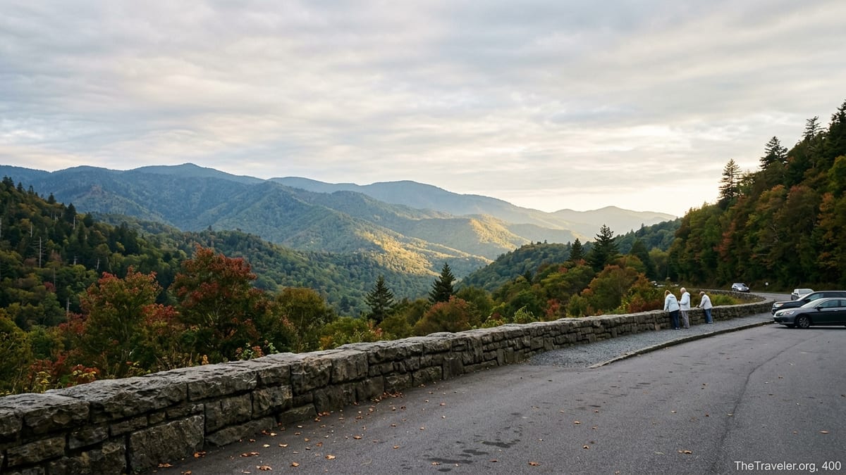
Newfound Gap Road is the only paved route that fully crosses Great Smoky Mountains National Park from north to south, climbing from the hustle of Gatlinburg to the quieter gateway of Cherokee. Along those 31 or so miles, you gain and lose more than 3,000 feet in elevation, passing through several forest zones that feel like a road trip from Georgia to Maine compressed into an hour. At its high point near Newfound Gap itself, the road tops out around 5,000 feet, where spruce and fir crowd the slopes and summer temperatures can run 10 to 15 degrees cooler than in the valleys.
Because it is the park’s primary east–west spine, the road links more than just viewpoints. Sugarlands Visitor Center near Gatlinburg anchors the Tennessee side, while Oconaluftee Visitor Center serves as the North Carolina gateway. In between you have trailheads to some of the park’s signature day hikes, historic memorials, and turnouts where you can watch low clouds snag on the ridgelines after a summer storm. In practice, driving Newfound Gap Road is less like following a highway and more like slowly turning the pages of a living field guide to the Smokies.
That layered experience is one reason locals often advise first-time visitors to devote an entire day to this single road. A straight-through drive might take 35 to 45 minutes without traffic, but any realistic plan should bake in time for scenic pullouts, a short hike or two, and weather that can change from sunny blue sky at Sugarlands to cloud-wrapped mist at the gap itself.
From Valley Heat to High Country Cool: Microclimates on the Move
One of the surprises for first-time drivers is how dramatically the climate shifts along Newfound Gap Road. You might start in Gatlinburg on a July afternoon where the temperature hovers near 85 degrees Fahrenheit. By the time you reach Newfound Gap, that reading can drop into the upper 60s, with a stiff breeze pouring through the gap and cloud shadows racing over the ridges. In shoulder seasons like April and November, it is common to find blooming wildflowers near the lower elevations while patches of snow linger along shaded high-country pullouts.
Those microclimates are not just trivia for weather nerds. They shape what you will see and how you should prepare. In spring, the lower slopes along the West Prong of the Little Pigeon River erupt in trillium and spring beauty while the upper ridges are still leafless and brown. In October, fall color peaks earlier near the high elevations around Newfound Gap and Clingmans Dome, then trickles downslope over the following weeks, creating a multi-layered palette if you time your drive right.
Practically speaking, smart travelers pack like they are planning for two seasons in one day. A light puffy jacket or fleece, a hat, and a rain shell can make the difference between a quick photo stop and actually lingering at an overlook to watch the clouds shift. Drivers in winter and early spring should check the park’s road status updates before committing; Newfound Gap Road is plowed and is often open when other mountain roads are closed, but snow and ice can still prompt temporary closures at higher elevations.
History Etched in Stone at Newfound Gap
Midway along the route, Newfound Gap Overlook is the emotional and historical heart of the drive. The large stone platform and memorial here mark the Tennessee–North Carolina state line and sit just above 5,000 feet, with panoramic views into both states on a clear day. Visitors often snap the requisite photo straddling the line, one foot in each state, while wind whips over the ridge.
For travelers interested in the human story of the Smokies, this is where the road’s deeper meaning starts to come into focus. The Rockefeller Memorial, built from native stone, commemorates the role of the Rockefeller family in funding land purchases that helped create Great Smoky Mountains National Park during the 1930s. It was on this spot in 1940 that President Franklin D. Roosevelt dedicated the park, speaking to a crowd bundled against the mountain chill. Spending a few minutes reading the inscriptions and imagining that ceremony transforms the overlook from a simple viewpoint into a tangible chapter of conservation history.
Just as important, this is Cherokee homeland. Interpretive signs on both ends of the park, and exhibits at Oconaluftee Visitor Center, highlight how this road crosses lands that the Cherokee people called home for centuries, long before tourism brought gift shops and lodges to Gatlinburg and Cherokee. Pairing a drive over Newfound Gap Road with a visit to the Museum of the Cherokee People in Cherokee gives context to the ridgelines and valleys you see from the overlooks, grounding the scenery in a much older story.
Trailheads, Turnouts, and Easy Access to the Backcountry
Spend any time talking with hikers who know the Smokies, and you will hear Newfound Gap Road mentioned again and again, not as a scenic drive but as their gateway to some of the best trails in the region. Several marquee hikes begin just off the pavement. The Alum Cave Trailhead, for example, sits a short distance from the Chimneys Picnic Area. Day hikers leave their cars here to reach landmarks like Arch Rock, Inspiration Point, and Alum Cave Bluffs, or to make the all-day climb to Mount LeConte and its backcountry lodge.
Farther up toward the gap, a small parking area leads to the trail to Charlie’s Bunion, a rocky outcrop along the Appalachian Trail with dramatic drop-offs and sweeping views into North Carolina. Another spur accesses the Jump Off, where the mountain seemingly ends in a sheer cut that plunges into the valley below. These are not roadside attractions but genuine high-country hikes, yet they rely entirely on the access that Newfound Gap Road provides to the crest of the Smokies.
Even short nature walks gain depth from their proximity to the road. Families with small children can pull off at the Newfound Gap parking area, step directly onto the white-blazed Appalachian Trail for a short stroll through spruce-fir forest, and still be back at their vehicle in under half an hour. A little farther south, the spur road to Clingmans Dome, open seasonally, branches off Newfound Gap Road and leads to a half-mile paved path to an observation tower that, on a clear day, offers views that can stretch for dozens of miles. In each case, the road is the quiet enabler that makes big-mountain experiences feasible for people with only a few hours to spare.
Wildlife Encounters and the Reality of “Bear Jams”
Newfound Gap Road is also a prime corridor for wildlife sightings. Black bears, white-tailed deer, and wild turkeys are all commonly spotted from vehicles, especially in the early morning and late evening. On summer evenings, it is not unusual to see cars pulled onto every available turnout while people point cameras at a distant hillside where a bear feeds in a berry patch or a sow leads her cubs along the tree line.
These impromptu viewing sessions have become so frequent that visitors and rangers alike use the term “bear jam” to describe the traffic standstills they cause. What feels like a once-in-a-lifetime moment for a family from the Midwest can translate into an hour-long delay for anyone caught behind them on a narrow, two-lane mountain road. For that reason, rangers emphasize simple etiquette: use designated pullouts rather than stopping in the driving lane, stay inside your vehicle or well behind guardrails, and give wildlife plenty of space.
Responsible viewing also protects the animals that make the road so memorable. Bears that become accustomed to vehicles or human food can quickly become a hazard, sometimes leading to euthanization when they lose their fear of people. Travelers who appreciate Newfound Gap Road as more than a scenic shortcut understand that their behavior, from storing snacks properly to obeying posted speed limits, plays a role in preserving the wildlife that draws so many people here in the first place.
Driving Skills, Safety, and Seasonal Realities
On a map, Newfound Gap Road might look like a simple squiggle between Gatlinburg and Cherokee. Behind the wheel, the experience is more involved. The pavement coils through tight curves, climbs steep grades, and threads along slopes where drop-offs fall away beyond stone guardwalls. Drivers who grew up on flat highways can find the combination of switchbacks, changing weather, and distracted sightseers challenging, especially when the road is busy.
The park service advises using lower gears on downhill sections to avoid overheating brakes, a particularly important consideration for drivers coming down from Newfound Gap toward either side of the park. Pullouts appear frequently, and using them to let faster traffic pass is as much a safety measure as a courtesy. Commercial vehicles are prohibited, and rangers periodically staff checkpoints at park entrances to prevent heavy trucks from using the road as a shortcut between North Carolina and Tennessee.
Seasonal considerations add another layer. In winter and early spring, snow and ice can coat the high sections of the road even when Gatlinburg’s streets are clear and wet. Temporary closures are common when conditions deteriorate, and visitors who book winter cabins in nearby communities often learn to build flexibility into their plans. In fall, when leaf color peaks and visitor numbers surge, traffic lines can form behind a single slow-moving RV. Travelers who treat the drive as part of the trip rather than an obstacle tend to cope better with these delays.
Practical preparation goes a long way. There are no gas stations inside the park, so topping off the tank in Gatlinburg, Cherokee, or nearby Townsend is a smart move. Mobile data signals can be weak or nonexistent along much of the route, so downloading offline maps before entering the park helps navigation and reduces the temptation to fumble with phones in tight curves.
Culture, Gateways, and Small-Town Stops on Both Ends
What happens before and after you drive Newfound Gap Road is part of the story. On the Tennessee side, Gatlinburg and nearby Pigeon Forge operate almost like an entertainment buffer between the outside world and the park. Families often spend the morning at attractions like aquariums or mountain coasters, then shift gears and drive up into the park in the late afternoon when crowds thin out. That transition, from neon signs and pancake houses to misty ridgelines and rhododendron tunnels, can feel more dramatic when you view the road as a bridge between two very different environments.
On the North Carolina side, Cherokee offers a calmer base with deep cultural roots. Here, travelers can stay in locally owned motels or cabins, visit the Museum of the Cherokee People to learn about the region’s Indigenous history, then drive up Newfound Gap Road in the morning as clouds begin to lift from the river valleys. A traveler who spends one night on each side of the park will experience the road differently in each direction: dawn light filtering through trees on the climb from Cherokee to the gap, and golden-hour light slanting across the ridges on the descent toward Gatlinburg.
These small-town bookends also affect the flow of traffic and visitor behavior. Most people enter from the Tennessee side, where lodging density is far higher, which means the Gatlinburg end of Newfound Gap Road tends to feel busier, especially between late morning and midafternoon. Travelers who are flexible can reverse the pattern by staying in Cherokee and starting their drives before the main wave of traffic crests over the gap from the north.
The Takeaway
Newfound Gap Road is not simply a scenic highlight to tick off a Smokies checklist. It is the main artery of a complex mountain ecosystem and a living museum of cultural, historical, and natural stories. You can experience multiple climate zones in a single day, step onto the Appalachian Trail without carrying a backpack for days, watch clouds pour through a high mountain pass where a president once dedicated a national park, and glimpse black bears moving along ancient forest corridors, all without leaving the shoulder of US 441 for more than a few minutes.
Travelers who get the most out of this road approach it with patience and curiosity. They build in time to pull over, to hike a mile or two, to read the plaques at the Rockefeller Memorial, to walk through the exhibits at Sugarlands and Oconaluftee, and to sit quietly at an overlook while the light shifts across the mountains. They pack layers, bring snacks, top off the gas tank, and embrace traffic delays as opportunities to notice details they might otherwise rush past.
Seen that way, Newfound Gap Road becomes the spine of a Smokies trip rather than the space between attractions. Whether you are visiting for a single afternoon or weaving it into a longer backcountry or cultural itinerary, the road invites you to slow down and understand why this stretch of the southern Appalachians was considered worth protecting in the first place.
FAQ
Q1. How long does it take to drive Newfound Gap Road without stopping?
In light traffic, the 31-mile drive between Gatlinburg and Cherokee typically takes about 35 to 45 minutes, but most travelers should allow at least two to three hours with scenic stops.
Q2. Is Newfound Gap Road open year-round?
The road is maintained year-round and is often open when other mountain routes are closed, but snow, ice, and downed trees can lead to temporary closures at higher elevations in winter and early spring.
Q3. Do I need a parking tag to stop at overlooks and trailheads?
Yes, Great Smoky Mountains National Park requires a paid parking tag for most vehicles that are parked for more than a very brief period, including at popular overlooks and trailheads along Newfound Gap Road.
Q4. Can I drive an RV or trailer on Newfound Gap Road?
RVs and trailers are allowed, but the road is steep, narrow, and winding, with tight curves and frequent traffic. Drivers should be comfortable with mountain driving and use low gears on descents; commercial trucks are not allowed.
Q5. What is the best time of day to avoid traffic on Newfound Gap Road?
Early morning and late afternoon typically see lighter traffic, especially during peak seasons. Starting your drive before about 9 a.m. or after midafternoon increases your chances of finding parking at major overlooks and trailheads.
Q6. Where can I access the Appalachian Trail from Newfound Gap Road?
The easiest access is directly at Newfound Gap Overlook, where the Appalachian Trail crosses the parking area. Other trailheads along the road connect to the AT via side trails, including those to Charlie’s Bunion and the Jump Off.
Q7. Are there restrooms along Newfound Gap Road?
Restrooms are available at Sugarlands Visitor Center near Gatlinburg, at the main Newfound Gap parking area, and at Oconaluftee Visitor Center near Cherokee, but there are no services at most intermediate pullouts.
Q8. Is Newfound Gap Road safe to drive in rain or fog?
The road remains open in most rainy or foggy conditions, but visibility can drop quickly, and curves can be slick. Slowing down, using headlights, and avoiding sudden braking or passing maneuvers help keep the drive safe.
Q9. Can I rely on cell service and GPS along the road?
Cell coverage is spotty or absent across much of Newfound Gap Road, and navigation apps may not update consistently. Downloading offline maps before entering the park is strongly recommended.
Q10. What should I bring for a day exploring Newfound Gap Road?
Plan on layered clothing for changing temperatures, water, snacks or a picnic, a paper or downloaded map, full fuel in your vehicle, and sturdy walking shoes if you intend to explore overlooks or trails.