


The Canary Islands are one of Europe’s most varied hiking destinations, mixing active volcanoes, cloud forests, black-sand coastlines and high alpine moonscapes within a short flight of mainland Spain. This guide focuses on the most rewarding areas for hikers – Teide National Park and Anaga in Tenerife, the trails of La Palma, and the laurel forests of La Gomera – with practical advice on volcanic routes, barrancos, viewpoints, permits, weather and what to pack underfoot.
Get the latest updates straight to your inbox!
How the Canary Islands Work for Hikers
The Canary Islands sit off the northwest coast of Africa, and their volcanic origins create sharp relief in a relatively small area. Tenerife, Gran Canaria, La Palma, La Gomera, El Hierro, Lanzarote and Fuerteventura each have distinct personalities, but hikers tend to gravitate to Tenerife, La Palma and La Gomera because of their dense trail networks and protected natural parks. Flight connections from mainland Spain and other European hubs are frequent, and inter-island ferries and short domestic flights make island hopping straightforward if you plan a longer trekking trip.
On the ground, the terrain changes quickly. You might hike in a cool, humid laurel forest before lunch, cross dry pine forest in the afternoon and end the day above a sea of clouds at 2,000 meters. This vertical variety means you can base yourself in a single village, such as Vilaflor in southern Tenerife or El Paso on La Palma, and still access a wide range of routes from family-friendly circuits to demanding full-day volcanic traverses.
Trail marking is generally good, especially on official GR long-distance routes and in national parks. However, conditions can change after wildfires, heavy rain or eruptions. Before tackling longer days, it is worth stopping by local tourist offices or checking the latest updates from island councils, particularly in La Palma where parts of the network have been periodically closed or rerouted following the recent Cumbre Vieja eruption and wildfires.
In terms of cost, hiking itself is mostly free. You might pay 5 to 15 euros for parking at busy trailheads or for a cable car ride in Teide National Park, but otherwise your main expenses are transport, accommodation and gear. Rural guesthouses and small hotels in hiking hubs often include early breakfasts and packed-lunch options, which can justify slightly higher room rates compared with beach resorts.
Teide National Park: High-Altitude Volcanic Hiking
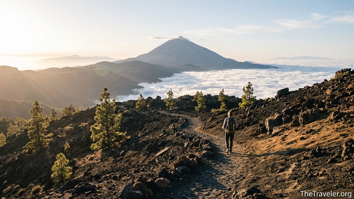
Teide National Park in the center of Tenerife is built around Mount Teide, Spain’s highest peak at 3,715 meters. Much of the park sits on a high plateau between 2,000 and 2,300 meters, so even moderate trails feel dramatically elevated, with big skies, sharp light and wide views. The terrain ranges from smooth pumice and ash to jagged lava flows and ochre rock formations. Well known viewpoints such as Roques de García can be reached on clearly signed paths from roadside parking, which makes the park accessible even if you are not aiming for the summit.
Summiting Mount Teide requires planning. You can either take the cable car from the base station to around 3,555 meters and hike the final section, or climb on foot from trailheads like Montaña Blanca. In both cases, access to the very top is controlled by a free permit system with timed slots. These permits need to be reserved in advance and printed to show alongside your ID at the control point near the upper cable car station. Availability often disappears weeks ahead in peak months such as February, Easter and October, so it is wise to check dates before booking flights if the summit is a priority.
Even if you do not have a summit permit, there are excellent high-level walks. The circular route around Roques de García gives an accessible introduction to the volcanic landscape with around 150 meters of ascent and big views of the Teide cone and the caldera walls. The trail to Pico Viejo viewpoint from the upper cable car station is another highlight, with a panoramic balcony looking into a huge crater. Remember that temperatures at 3,500 meters can be close to freezing at sunrise in winter, even when the coast is warm, and strong sun reflection from pale rock makes sunglasses essential.
Because of the altitude and exposure, footwear and clothing decisions matter. Light trail-running shoes with good grip are sufficient for well-maintained tracks and short loops, but boots with some ankle support feel more secure on loose lava gravel and steep cinder slopes. In practice many experienced hikers wear low-cut approach shoes and carry lightweight trekking poles for descents. Pack layers, a warm hat and thin gloves outside midsummer, and always carry more water than you think you will need, since there are no natural water sources on the plateau and services are limited to a few roadside cafes and the cable car station.
Anaga: Cloud Forests, Barrancos and Atlantic Ridges
Anaga Rural Park occupies Tenerife’s northeastern tip and is a UNESCO Biosphere Reserve known for its laurel forests, knife-edge ridges and plunging ravines, or barrancos. Compared with the open lunar landscape of Teide, Anaga feels intimate and humid, with moss-covered trees, ferns and frequent mist. Well known easy circuits such as the “Trail of the Senses” near Cruz del Carmen provide wooden walkways and viewpoints for families, while steeper coastal paths around villages like Taganana and Taborno offer more sustained climbs and descents.
The classic experience in Anaga is a ridge walk that links the interior forest with the sea. For example, a route from the Cruz del Carmen viewpoint down to the village of Chinamada passes traditional cave houses dug into the rock, then follows balcony paths above deep barrancos before dropping toward the coast. Another popular day links the hamlet of Taborno with surrounding ridges, giving continuous views of the Anaga spine and the Atlantic, with drops of several hundred meters on each side. On these hikes you will often share narrow paths with local farmers and residents carrying supplies, a reminder that many of the trails began as everyday routes rather than recreational paths.
Weather in Anaga is heavily influenced by the trade winds. Even in July and August, cloud can sit at 700 to 1,200 meters, soaking the forest and making wooden steps and roots slick. Packing a light waterproof jacket and shoes with reliable wet grip is more important here than on Teide’s dry pumice. In winter, evening temperatures in high villages can drop below 10 degrees Celsius, while the coast remains mild enough for swimming, so bringing a warm mid-layer is sensible even if you are staying in beach areas like Santa Cruz or San Andrés.
Transport logistics require thought. Parking at popular trailheads such as Cruz del Carmen can fill up quickly on weekends and local holidays. Many visitors stay in Santa Cruz de Tenerife or La Laguna and drive 30 to 45 minutes into the park for day hikes, but public buses also connect key gateways and allow one-way hikes between ridges and coast if you plan schedules carefully. A practical example is hiking down from the Anaga ridge to the beaches near Taganana and then taking an afternoon bus back up, avoiding a very steep return climb in the heat.
La Palma: Volcanic Ridges, Caldera Views and Evolving Trail Access
La Palma is often marketed as “La Isla Bonita” and has long been a favorite for hikers seeking quieter trails and deep volcanic scenery. Two major structures define its landscape: the Caldera de Taburiente in the north, a massive erosion crater with steep pine-clad walls, and the Cumbre Vieja ridge in the south, which hosts the youngest volcanic features on the island. Recent volcanic activity and wildfires have led to periodic closures and rerouting of official trails, so it is important to check the latest maps and notices from the island council or visitor centers before setting out.
One of the most iconic routes is the Ruta de los Volcanes, which follows the Cumbre Vieja ridge, typically between El Pilar recreation area and Fuencaliente in the south. On a clear day, this is a full-day undertaking with cumulative ascents and descents over old cones, ash slopes and pine forest. You will pass sequences of historic craters and lava fields, with views across the Aridane Valley and down to the Atlantic. Sections around the most recent eruption area are sometimes restricted or diverted, and guided tours may be recommended for entering newly formed terrain, where access rules can change within a season.
Inside Caldera de Taburiente National Park, popular day hikes start from the Mirador de La Cumbrecita or from trailheads higher up the caldera rim. A common plan is to walk from La Cumbrecita to viewpoints such as Lomo de las Chozas, which looks deep into the caldera and across to rugged ridges. Another demanding circuit drops from Los Brecitos into the caldera floor and exits through the Barranco de las Angustias, a long ravine that often involves shallow river crossings and some boulder hopping. After recent fires, some sections have reopened while others remain closed or signed as dangerous, so rangers’ advice is crucial.
La Palma’s small towns are well set up for hikers. Villages like El Paso and Los Llanos have gear shops selling gas canisters, lightweight waterproofs and replacement trail shoes from familiar brands. Many rural accommodations offer early breakfasts, gear-drying rooms and information on current trail conditions. Compared with Tenerife, grocery prices can be slightly higher due to smaller supermarkets, but local fruit, cheese and baked goods are widely available for trail snacks. Renting a compact car is usually the most efficient way to move between trailheads, as public transport in rural areas can be sparse and infrequent.
La Gomera: Garajonay Forests and Island-Crossing Routes
La Gomera, west of Tenerife, is smaller than La Palma but packs in a surprising range of landscapes. The center and north are dominated by Garajonay National Park, a UNESCO World Heritage Site of ancient laurel forest formed under constant cloud and moisture. Here the trails are soft underfoot, lined with moss and ferns, and shaded by twisted trees. The highest point, Alto de Garajonay at around 1,487 meters, can be reached on a short but steep path from the Pajarito area, rewarding hikers with panoramic views toward Tenerife, El Hierro and Gran Canaria on clear days.
Several marked routes within Garajonay create half-day circuits suitable for most reasonably fit walkers, starting from trailheads such as La Laguna Grande or Contadero. These loops are ideal introductions to the “mist forest” environment, often completed in two to four hours with modest elevation change. Waymarking is clear, but a simple paper map from local information centers or your accommodation helps when combining multiple loops into longer days. Because the forest holds moisture, paths can be muddy even after a few dry days, and wooden steps and bridges may grow slippery algae.
Beyond the park, La Gomera is laced with island-crossing trails, including long-distance routes that circle or traverse the island’s ravines and ridges. For example, hikers often tackle sections of the GR 132 coastal circuit or the GR 131 spine route over several days, using small coastal villages and hill towns as overnight bases. One itinerary might link Valle Gran Rey in the southwest with the central highlands and then descend toward San Sebastián de La Gomera, tying together laurel forest, terraced slopes and arid canyon-like barrancos in a single multi-day journey.
Services on La Gomera are more limited than on Tenerife. In village hubs like Valle Gran Rey, Hermigua or San Sebastián you will find small supermarkets, bakeries and simple restaurants where a post-hike plate of grilled fish and papas arrugadas with mojo sauce is a staple reward. However, many trailheads have no facilities, so carrying sufficient water and snacks is essential. The island’s road network is extremely winding; driving 20 kilometers can take 40 minutes, which affects how you plan linear hikes and car shuttles. Ferries from Tenerife’s ports typically bring hikers in the morning, leaving plenty of daylight for a first short walk if you arrive prepared.
Volcanic Trails, Barrancos and Viewpoints: What to Expect Underfoot
Across Tenerife, La Palma and La Gomera, you will encounter recurring types of terrain. Volcanic trails often consist of loose cinder, pumice sand and sharp lava rock. On Teide and Cumbre Vieja, these surfaces can feel like walking on a mix of gravel and deep ash, which saps energy on climbs and can be slippery on descents. Many hikers find that shoes with slightly stiffer soles and aggressive tread, similar to all-terrain trail runners or light hiking boots, reduce foot fatigue and provide better control. Gaiters can help keep fine black sand out of your socks on long days.
Barrancos, the steep ravines that slice into the islands, are another hallmark. Anaga’s coastal hikes often involve descending 600 to 900 vertical meters on stepped paths into a barranco, crossing a streambed or small settlement, then climbing back out. In La Palma, the Barranco de las Angustias functions as both a trail and a drainage channel, so you may walk on polished river stones and through shallow water, especially after rain. Trekking poles make these descents more comfortable and help protect knees, while shoes with rock plates or thicker soles shield your feet from sharp stones.
Viewpoints are everywhere, but some stand out for hikers. In Teide National Park, Mirador de La Ruleta near Roques de García frames the peak and caldera walls in a single panorama. In Anaga, simple roadside miradores above the TF-12 road, such as Mirador Cruz del Carmen, overlook deep green ridges and the north coast. La Palma’s Mirador de La Cumbrecita gives a dramatic balcony into the caldera, and on La Gomera the summit of Alto de Garajonay provides a 360-degree sweep of ocean and neighboring islands. Many of these viewpoints can be reached either by short walks from parking areas or as part of longer routes, so you can adapt your plans to group ability and weather.
Because viewpoints and barrancos often involve exposure, it is important to be realistic about everyone’s comfort with heights. Paths are generally secure, but some sections traverse steep slopes with notable drop-offs. Families with younger children often opt for forest circuits and wide ridge tracks first, saving narrow balcony paths for when everyone feels confident. Locals commonly start demanding routes early in the morning to avoid midday heat in exposed gullies, something visitors can copy to enjoy cooler temperatures and quieter trails.
Weather, Seasons, Permits and Safety
The Canary Islands are marketed as year-round destinations, but hiking conditions vary by season and altitude. In winter, from December to March, coastal temperatures are mild, often around the high teens to low twenties Celsius, while high areas such as Teide and Garajonay can experience frost, occasional snow and strong wind. Spring and autumn usually offer the best balance of stable weather, cooler temperatures for climbs and longer daylight. Summer can be hot in exposed lower areas and south-facing slopes, but cloud cover and altitude often moderate conditions in the interior and highlands.
Weather patterns differ between islands and even within a single mountain range. Trade winds typically bring moist air to north and northeast slopes, feeding Anaga’s cloud forest and La Gomera’s laurisilva, while south-facing slopes remain much drier. This means you might need a waterproof shell and warm layer for a morning walk in the forest, then switch to sunhat, sunscreen and extra water for an afternoon traverse on dry volcanic rock. Checking the forecast for specific elevations rather than just coastal towns helps, and many local weather apps and services allow you to set favorite locations such as Teide’s cable car station or Garajonay’s high points.
Permits matter in a few key locations. The summit section of Mount Teide is strictly controlled, with a daily quota managed via an online reservation system. Free permits must be obtained for a specific time window, and you will be turned back without one, even if you have bought a cable car ticket. In contrast, most other national parks and rural parks allow permit-free access for day hiking, though certain sensitive zones may be temporarily closed to protect nesting birds, control erosion or allow post-fire restoration. In La Palma’s volcanic areas, guided tours may be required for some new lava fields, reflecting both safety concerns and the need to protect fragile ground.
General safety considerations are simple but important. Mobile coverage is reasonably good on main ridges and near towns, but it can vanish in deep ravines and remote coastal sections, so informing your accommodation of your plans is wise before longer outings. Carrying a small first-aid kit, a headlamp even for day hikes, and a paper map or offline GPS map on your phone ensures redundancy if batteries die or electronics fail. Tap water is usually safe to drink in urban areas, but many hikers prefer to carry bottled or filtered water on the trail to avoid stomach issues mid-hike.
Choosing the Best Island for Your Hiking Style
If you only have one week and want a mix of iconic volcanic scenery and lush forests, Tenerife is often the most practical choice. You can base yourself in a mid-altitude village such as La Orotava or La Laguna and split your time between Teide’s high plateau and Anaga’s ridges and barrancos, all while enjoying relatively short drives and a wide range of accommodation. This combination suits hikers who like day walks with occasional big efforts, rather than multi-day traverses, and who appreciate returning to a town with restaurants and shops each evening.
La Palma appeals to hikers who enjoy long days on ridgelines and are comfortable dealing with route changes and closures as conditions evolve. The island rewards repeat visitors who get to know its networks of paths, seasonal weather quirks and local access rules. If your ideal day is six to eight hours on a high volcanic ridge with significant ascent and descent, and you do not mind some logistical research, La Palma delivers exceptional value. It is also less developed for mass tourism than Tenerife, which means quieter trails but fewer backup options if weather closes in on your planned route.
La Gomera is arguably the best fit for walkers who enjoy dense networks of waymarked paths and multi-day journeys between small villages. Shorter daily stages can thread cloud forests, terraces, ravines and cliffs in quick succession without extreme altitude, making the island accessible to a wide range of fitness levels. Many visitors combine La Gomera with a night or two on Tenerife to experience Teide, using regular ferries between the islands. For dedicated hikers with 10 to 14 days, an itinerary that links Tenerife, La Gomera and La Palma creates a complete picture of the archipelago’s volcanic landscapes.
In practice, budget, flight schedules and accommodation availability may decide for you. During school holidays and major European vacation periods, rural guesthouses in popular hiking bases can sell out months ahead, while coastal resorts still have space. Booking cancellable accommodation gives you flexibility if updated information on trail closures or ferry timetables leads you to adjust your island mix. Regardless of which island you choose, investing time before arrival to understand local bus systems, hire-car options and the location of gear shops will make your hiking days smoother and more rewarding.
FAQ
Q1. Do I need a permit to hike in Teide National Park and reach the summit?
For general day hikes in Teide National Park you do not need a permit, but the final summit section of Mount Teide is restricted. A free, timed summit permit must be reserved in advance and presented with your ID at the control point near the upper cable car station, regardless of whether you hiked up from Montaña Blanca or used the cable car.
Q2. What kind of footwear is best for Canary Islands volcanic trails?
Most hikers are comfortable in sturdy trail-running shoes or lightweight hiking boots with good grip and a slightly stiff sole. On loose lava, pumice and sharp rock, a grippy outsole and decent underfoot protection matter more than heavy ankle support. Trekking poles are helpful on steep, dusty descents and in rocky barrancos.
Q3. When is the best time of year to hike in the Canary Islands?
Spring and autumn usually offer the best balance of mild temperatures, stable weather and daylight hours. Winter is excellent on the coasts but can bring snow, ice and strong wind to high areas such as Teide and Garajonay, while summer can be hot in exposed lowlands. Year-round hiking is possible if you adapt your routes to altitude and forecast.
Q4. Are trails on La Palma open after the recent eruptions and wildfires?
Many key routes on La Palma, including sections of the Ruta de los Volcanes and paths in Caldera de Taburiente, have reopened, but some segments remain closed or rerouted. Conditions change as restoration progresses, so always check the latest information from the island council or park visitor centers before planning longer days.
Q5. Is Anaga suitable for beginners or only for experienced hikers?
Anaga offers both. Short, well-prepared circuits such as the Trail of the Senses near Cruz del Carmen are ideal for beginners and families, while longer ridge and coastal routes with big elevation changes suit experienced hikers. Choosing loop walks with clear waymarking and avoiding the steepest barrancos is a good strategy for first-time visitors.
Q6. How does hiking on La Gomera compare with Tenerife and La Palma?
La Gomera focuses more on laurel forests, ravines and multi-day village-to-village routes than on high volcanic summits. Trails are dense and often well marked, with moderate elevation changes spread over shorter distances. It is an excellent island for walkers who enjoy continuous movement through varied landscapes rather than single big peaks.
Q7. Do I need a car, or can I rely on public transport for hiking?
You can reach many trailheads using public buses, especially around Anaga, Garajonay and some parts of La Palma. However, bus timetables can be limited, and connections between remote villages may be infrequent. Renting a small car gives maximum flexibility, particularly if you want early starts, linear routes or access to multiple trailheads in a single day.
Q8. What should I pack for a typical day hike in the Canary Islands?
A comfortable daypack with at least 1.5 to 2 liters of water per person, sun protection, a light waterproof jacket, snacks or lunch, a warm layer for higher altitudes, and a basic first-aid kit is a good baseline. Add trekking poles for steep or loose terrain, and consider gaiters on ash-heavy routes like parts of Teide or Cumbre Vieja.
Q9. Are there guided hikes available if I do not want to navigate alone?
Yes, most islands have local mountain guides and small agencies that offer group or private hikes ranging from half-day forest walks to full-day volcanic traverses. Guided trips are particularly useful for recently affected areas on La Palma, sunrise or sunset hikes on Teide, or complex line routes where transport logistics could otherwise be difficult.
Q10. Which island is best if I want a week focused almost entirely on hiking?
For a first dedicated hiking week, Tenerife is a strong choice because you can combine Teide and Anaga with minimal travel time. If you prefer quieter trails and are happy with more complex logistics, La Palma is excellent for long volcanic ridge days. La Gomera is ideal if you enjoy multi-day point-to-point walks between small villages with frequent forest and ravine scenery.