
From the seafront promenade in central Naples, Vesuvius dominates the skyline. Yet it was not the famous cone across the bay that changed how I understood the power beneath this city. It was the low, unassuming hills to the west, the Phlegraean Fields, where the ground itself quietly breathes, rises, and sinks under the weight of hidden magma and hot water. Walking, boating, and even swimming through this restless landscape, I realized that life around Naples is shaped as much by what you cannot see as by the postcard volcano in every picture.
Get the latest updates straight to your inbox!
Meeting the Hidden Volcano West of Naples
I first heard the name Campi Flegrei on a commuter train leaving central Naples. The Cumana line rattles out from Montesanto station and in less than half an hour you are in Pozzuoli, a port town that sits directly inside one of the most studied volcanic calderas in the world. There are no towering peaks here. Instead, gentle slopes, built-up neighborhoods, and crowded cafes hide a vast, shallow magma and hydrothermal system a few kilometers below the surface.
Geologists describe the Phlegraean Fields as a caldera about 12 to 15 kilometers across, pocked with more than twenty craters and volcanic centers. The last eruption, at Monte Nuovo in 1538, raised a new hill almost within walking distance of Pozzuoli’s waterfront. Today, the main signs of unrest are not lava fountains but subtler signals: clusters of small earthquakes, the smell of sulfur, and a phenomenon called bradyseism, the slow rising and sinking of the ground as fluids move in the crust.
That word, bradyseism, stayed abstract until I reached the heart of Pozzuoli and stood before three marble columns streaked with bands of old shell borings. Locals still call the site the Temple of Serapis, although archaeologists later identified it as an ancient market building. The upper parts of the columns are riddled with holes from marine organisms that once lived below sea level, clear proof that the land has been submerged and then lifted again over centuries as the caldera pulsed.
Unlike the dramatic single eruptions that shaped Pompeii, Campi Flegrei expresses its power in these long, unsettling cycles. In recent decades, the town has experienced repeated episodes of uplift measured in tens of centimeters, enough to crack pavements and warp harbor walls. Scientists from the Italian National Institute of Geophysics and Volcanology track the changes with GPS and satellite data, issuing regular bulletins that locals follow as closely as weather reports. For a visitor, this scientific presence is a reminder that the pleasant seafront and busy pizzerias sit on a living system.
Walking on Breathing Ground in Pozzuoli
On the surface, Pozzuoli does not feel like a town living under constant geological surveillance. On a weekday morning, the fish market still spills out by the port, and ferries depart for Procida and Ischia. Yet small details betray the restless ground. Along the waterfront, you can see where the level of the quays has had to be adjusted to keep pace with uplift, and just inland, some facades are crisscrossed with hairline fractures that residents shrug off as part of life here.
At the former Macellum, interpretive panels explain how the ground has moved several meters up and down since Roman times. The building’s lower floors are now dry, but old photographs show them half flooded in the 20th century when subsidence allowed seawater to creep in. Guided tours often point out the contrast between the ancient damage and more recent cracks from the 1980s unrest, when thousands of residents were temporarily evacuated from central Pozzuoli after intense seismic swarms and rapid uplift.
In the historic Rione Terra district, a terrace now offers a sweeping view across the bay to Nisida and Vesuvius, yet the real story lies beneath the stone lanes. Archaeologists have been excavating a Roman city here, preserved under later buildings. For travelers, the layered history is emblematic of the Phlegraean Fields: modern life stacked over ancient streets, all resting on a moving volcanic floor. You walk between Baroque churches and contemporary apartment blocks, aware that both are anchored to rock that may shift again within a human lifetime.
Even everyday decisions reflect the volcano’s presence. Some local families keep mental maps of evacuation routes and follow municipal advice about assembly points. Real estate agents quietly factor volcanic risk into prices, with some areas of Pozzuoli often more affordable than fashionable quarters of Naples despite sea views and easy train access. As a visitor arriving on a ticket that costs only a few euros, you step into this long negotiation between people and geology.
Steam, Sulfur, and Silence: Craters and Fumaroles
Leaving the tight lanes of Pozzuoli for the cratered interior of Campi Flegrei, the mood changes. The road climbs to viewpoints where you can see that you are standing inside a vast depression edged by low rims of hills. Turnoffs lead toward fumarolic fields, quiet crater lakes, and ridges with views of both the Bay of Naples and the inner caldera. Here the volcanic system shows itself in steam and hot ground rather than city cracks.
One of the most evocative places is the area around Lake Avernus, a calm, circular lake filling part of an old crater. In Roman times it was imagined as a gateway to the underworld; today a running path circles the shore, and small vineyards climb the slopes. When I visited, a family was picnicking near a patch of warm soil where wisps of steam escaped. Signs explained that gas vents here emit carbon dioxide and other volcanic gases, generally diffuse but carefully monitored.
Not far away, small fumarolic zones create miniature moonscapes. Patches of bare earth are stained yellow and white by sulfur and mineral deposits, and the air carries a tang similar to struck matches. Some historic sites of this kind, like the well-known Solfatara crater on the edge of Pozzuoli, have been closed to the general public for safety reasons after past accidents. Local guides and tourism boards typically direct visitors instead to safer viewpoints, road-accessible overlooks, and boat trips where the volcanic landscape can be appreciated at a distance.
What strikes you in these quieter spots is the contrast between the violence suggested by the geology and the ordinariness of daily life. A school bus may pass a steaming hillside on its way to a suburban campus. A vineyard might border a fenced-off fumarole zone. The Phlegraean Fields are not a remote wilderness but an inhabited volcanic field woven into the commuter belt of a major Italian city.
Discovering the Submerged City of Baia
If Pozzuoli teaches you that the ground moves, Baia shows what can happen when it sinks. Once a luxurious Roman resort town favored by emperors and senators, Baia’s shoreline slid gradually below sea level as bradyseism lowered parts of the coast. Today, much of that ancient opulence lies under shallow water, protected within the Underwater Archaeological Park of Baia.
On a clear afternoon, I boarded a small boat from the marina beneath the Aragonese castle of Baia. Tour operators in the area offer glass-bottom boat trips and guided snorkeling excursions that typically last a couple of hours. Prices vary depending on the season and whether you choose snorkeling or scuba diving, but many visitors can expect to pay in the range of a modest day tour from Naples, including equipment rental and guide.
Even if you stay dry, the impact is strong. Through the glass, geometric patterns of black-and-white mosaics become visible, along with columns, paving stones, and low walls softened by algae and seagrass. Guides point out the outlines of structures such as Villa a Protiro and parts of the ancient Portus Julius, the Roman naval base that once hosted fleets protecting the empire’s western seas. In certain spots, sunlight slants through the water, illuminating details of floor designs that would not look out of place in a museum.
For certified divers, local dive centers based in Baia and nearby towns organize trips to a series of underwater sites between roughly 5 and 13 meters deep. These include ruins associated with elite villas, thermal baths, and harbor installations built with Roman marine concrete. The sensation is less of entering a shipwreck and more of drifting over streets paused mid-sentence. Fish dart among column bases, and every so often you can trace the curve of a submerged staircase. This, more than any textbook diagram, conveys how the land has warped over centuries under the influence of the volcano.
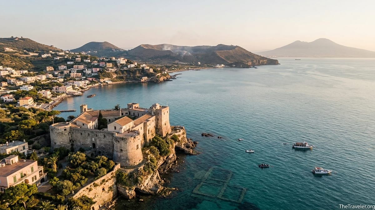
Castles, Cisterns, and the Mythic Edge of the Caldera
Above the underwater ruins, the Aragonese Castle of Baia stands guard on a headland. Within its walls, the Archaeological Museum of the Phlegraean Fields gathers sculptures, inscriptions, and architectural fragments from sites spread across the caldera, including Cuma, Pozzuoli, and the coastal villas. Touring its galleries, you see marble statues recovered from the seafloor displayed beside pieces excavated inland, emphasizing that bradyseism has rearranged the coastline but not erased its history.
Farther along the coast in Bacoli, a seemingly unremarkable residential area hides one of the most atmospheric structures in the region: the Piscina Mirabilis. Carved into the tuff hillside, this enormous Roman cistern once stored water for the naval fleet at Misenum. Visitors descend a stairway and emerge into a forest of stone pillars that feels almost like the nave of a submerged cathedral. Here, the geology provided both the material and the void, as engineers cut into volcanic rock that originally formed as ash and lava.
On the inland flank of the caldera lies Cuma, a plateau overlooking the sea that hosted one of the earliest Greek settlements in mainland Italy. The archaeological park here includes temples, fortifications, and the rock-cut passage known as the so-called Cave of the Cumaean Sibyl. Standing inside the long, sloping corridor, illuminated by narrow side openings, it is easy to understand why ancient authors placed oracles and underworld journeys in this landscape of fog, fumes, and unstable ground.
Everywhere in Campi Flegrei, myth, history, and volcanology overlap. A crater lake might be both a site of Greek legend and a point on a modern risk map. A castle may hold both Renaissance gun loops and display cases explaining geothermal measurements. For travelers, this layering makes the area an unusually rich place to grasp how humans interpret and adapt to a dynamic Earth.
Living With Risk: Safety, Science, and Responsible Travel
Because Campi Flegrei is an active volcanic area, authorities keep it under close observation. Networks of seismometers, gas sensors, and ground deformation monitors feed into a multi-level alert system. In recent years, small earthquake swarms have attracted headlines, and scientists periodically revise their assessments of the probability of future eruptions. For locals, these reports are part of the background of life; for visitors, they deserve respectful attention without alarmism.
Before visiting, it is sensible to consult the latest information from Italian civil protection and local tourism offices, which summarize the current alert level and any access restrictions. During periods of elevated unrest, certain zones may be temporarily closed or subject to special regulations. This can affect specific attractions more than others. For example, fumarolic craters might be off-limits while museums, coastal walks, and boat tours continue to operate as normal.
On the ground, common-sense precautions matter. Joining guided tours rather than venturing alone into marginal areas helps ensure that you stay within permitted zones and have someone who understands local procedures. Paying attention to signs, respecting fences around vents, and following any instructions from park staff and municipal authorities are simple ways to reduce personal risk and avoid placing additional burden on emergency services.
Responsible travel also extends to how we talk about the area. The Phlegraean Fields are sometimes described with dramatic labels in popular media, but residents and scientists alike often favor more measured language. Acknowledging that this is a complex, monitored system with uncertainties, rather than a ticking clock, respects both the science and the community. As a visitor, choosing local guides, eating at family-run restaurants in Pozzuoli or Bacoli, and staying in small guesthouses spreads economic benefits in an area that balances beauty, history, and hazard.
Planning Your Own Journey Beneath the Surface
Exploring the Phlegraean Fields typically begins in Naples. From the historic center, regional trains and the Cumana railway connect to Pozzuoli in about 30 minutes, often for the price of a local transit ticket. From there, local buses and taxis link key sites such as the Rione Terra, lakeside areas near Avernus, and coastal towns like Baia and Bacoli. Many travelers combine a day at Campi Flegrei with visits to Pompeii or Herculaneum, but the density of sites can easily justify dedicating two or more days solely to the western bay.
Accommodation options range from family-run bed-and-breakfasts overlooking Pozzuoli’s harbor to modern hotels near the train stations that cater to business travelers and weekend visitors from elsewhere in Italy. Staying overnight in the caldera rather than commuting back to Naples every evening lets you experience quieter times of day. Early morning walks along the lungomare, for instance, reveal fishermen preparing nets with Vesuvius and the low caldera rim both visible in the pale light.
Budgeting for a visit involves factoring in entrance fees to archaeological parks, museum tickets, and any specialized tours such as guided snorkeling at Baia or organized visits to underground structures like the Piscina Mirabilis. While prices change over time, travelers can expect individual site entry fees to be similar to other Italian archaeological attractions, with discounts often available for combined tickets or cultural passes. Guided experiences, particularly on the water, are usually the most significant individual costs but provide access and interpretation that individual travelers cannot easily replicate.
Seasonally, spring and autumn offer mild temperatures that make walking between sites comfortable, and visibility for underwater excursions is often good outside the busiest summer months. In the height of summer, heat on exposed crater rims and stone streets can be intense, so early starts, hats, and water are essential. Winter brings fewer crowds and a more local feel but can see some tours running less frequently, so advance checks with operators are advisable.
The Takeaway
Standing above the submerged mosaics of Baia, watching tiny waves lap over Roman floors now several meters underwater, I understood the Phlegraean Fields not as a single threat but as a long conversation between the Earth and its inhabitants. Here, the ground does not simply lie still beneath a city; it heaves, sinks, and exhales, shifting coastlines and reshaping lives over human timescales as well as geological ones.
Exploring this landscape changed how I thought about Naples. The city’s drama is not confined to the recognizable cone of Vesuvius but extends into the low hills and calm bays to the west, where an active caldera and a dense tapestry of history coexist. For travelers willing to look beyond the usual itinerary, Campi Flegrei offers a rare chance to see how science, myth, culture, and everyday resilience intersect on the edge of a restless volcano.
FAQ
Q1. Is it safe to visit the Phlegraean Fields given the volcanic activity?
Travelers visit Campi Flegrei in significant numbers, and authorities maintain extensive monitoring and an alert system. While there is always some background risk in an active volcanic area, official agencies adjust access and provide guidance when conditions change. Checking current advisories before your trip and following local instructions on the ground are the best ways to stay informed.
Q2. How do I get from central Naples to Pozzuoli and the main sites?
From Naples, frequent commuter trains and the Cumana railway connect to Pozzuoli in roughly half an hour. Once there, local buses, taxis, and organized tours link you to places like Baia, Bacoli, and Cuma. Some visitors also choose to rent a car for greater flexibility, though driving and parking in the urban parts of the caldera can be busy at peak times.
Q3. Can I still visit volcanic craters and fumaroles in Campi Flegrei?
Certain fumarolic and crater areas are accessible via marked paths or viewpoints, while others may be closed or restricted for safety reasons. Regulations can change, especially during periods of heightened unrest, so it is important to rely on updated information from local tourism offices, park authorities, or licensed guides rather than assuming past access conditions still apply.
Q4. Do I need to be a certified diver to experience the submerged ruins of Baia?
No. While certified divers can explore deeper sites with local dive centers, non-divers have several options. Glass-bottom boat tours allow you to see mosaics and structures from the surface, and guided snorkeling excursions provide a shallow-water view of key ruins. Tour operators typically supply equipment and basic instruction for beginners.
Q5. How much time should I plan to explore the Phlegraean Fields?
A single long day can cover highlights such as Pozzuoli’s historic center, a lakeside area, and a boat trip or snorkeling at Baia. However, spending two or more days allows for a more relaxed pace and time to include sites like the Archaeological Museum in the castle at Baia, the Piscina Mirabilis in Bacoli, and the ancient settlement at Cuma.
Q6. Are there guided tours that explain the geology as well as the archaeology?
Yes. In addition to standard archaeological tours, some operators and local guides specialize in combining volcanology and history, explaining bradyseism, past eruptions, and monitoring networks alongside visits to Roman remains. Asking specifically for a geology-informed tour when booking can help you find these options.
Q7. What should I wear and bring for a typical day in Campi Flegrei?
Comfortable walking shoes, sun protection, and a reusable water bottle are essential, especially in warmer months. If you plan to join a boat trip or snorkeling excursion, bring swimwear, a towel, and a light layer for breezy conditions on the water. In cooler seasons, a windproof jacket makes crater rims and coastal viewpoints more comfortable.
Q8. How does visiting Campi Flegrei compare to visiting Pompeii or Vesuvius?
Pompeii and the slopes of Vesuvius focus on a single catastrophic eruption and a single, prominent volcano. Campi Flegrei offers a more diffuse experience: smaller craters, submerged cities, and ongoing ground movement integrated into modern towns. Many travelers find that combining both areas provides a fuller picture of the volcanic forces shaping the Bay of Naples.
Q9. Are there family-friendly activities in the Phlegraean Fields?
Yes. Families often enjoy boat trips over the underwater ruins, walks around crater lakes like Avernus, and visits to castles and museums that mix outdoor space with exhibits. As with any volcanic area, caregivers should keep children close in fumarolic zones and follow posted safety instructions.
Q10. What is the best season to visit Campi Flegrei?
Spring and autumn typically offer mild temperatures and good conditions for walking and outdoor exploration. Summer brings warm seas that favor snorkeling and boat trips but can be hot on exposed archaeological sites and crater rims. Winter is quieter and more local in feel, with some tours operating less frequently but main towns and museums still open.