


Perched on a rocky peninsula at the northern tip of Saint Lucia, Pigeon Island’s Fort Rodney hike is one of the most accessible ways to earn sweeping Caribbean views without committing to a full mountain climb. Within an hour you can walk from calm beaches through centuries-old stone ruins to a hilltop fort and an even higher summit, Signal Peak, looking out across Rodney Bay and, on clear days, all the way to Martinique.
Get the latest updates straight to your inbox!
Getting Oriented: Pigeon Island, Fort Rodney and Signal Peak
Pigeon Island National Landmark sits at the northern end of Rodney Bay, linked to Saint Lucia’s mainland by a short causeway. From popular resorts such as The Landings or the hotels along Reduit Beach, it is typically a 5 to 15 minute taxi ride, or a 20 to 30 minute walk, to the park entrance. Inside the gate you will find a small ticket booth, restrooms, a basic map, and usually a staff member from the Saint Lucia National Trust who can answer quick questions about the trails and current conditions.
The landmark has two main high points. The first is Fort Rodney, on the lower of the two hills, crowned with cannons and stone walls dating back to the late 18th century when British Admiral George Rodney used the site to watch French naval movements. The second is Signal Peak, sometimes called Signal Hill, a steeper, rougher path that climbs higher behind the fort to a bare summit with nearly 360 degree views over Rodney Bay, the Caribbean Sea and Saint Lucia’s north coast.
For most visitors, the classic hike is to Fort Rodney only, which can comfortably be done in regular trainers in 20 to 30 minutes from the beaches. More confident hikers continue from the fort to Signal Peak, adding another 15 to 25 minutes of steeper, rockier trail. Both routes start from the same general area behind the park’s central lawn and museum building, and they can easily be combined into one outing of about 60 to 90 minutes of actual walking time, not counting photo and rest stops.
Because the island is compact, you can pair the hike with beach time, a casual lunch at the simple beach bar near the entrance, or an afternoon visit from a cruise ship stop in Castries. That flexibility makes Fort Rodney and Signal Peak ideal for travelers who want a memorable viewpoint hike without devoting an entire day or hiring a dedicated mountain guide.
Trail Difficulty, Steps and Walking Time
The Fort Rodney trail is short but can feel surprisingly demanding for anyone unused to heat, stairs or uneven ground. From the base near the lawns and museum, expect roughly 10 to 15 minutes of uphill walking to the fort, plus another 10 to descend. Much of this is on compacted dirt paths and a long flight of rough stone steps, with some wooden stair sections that can be high and uneven. People of average fitness who walk regularly usually manage the climb without trouble by taking a few short breathers.
Continuing to Signal Peak increases the difficulty. After you exit the fort and follow the path upward, the trail becomes narrower and more rugged, with some short rock scrambles where you may need to use your hands for balance. Reviewers often describe this section as a “sturdy climb” that is manageable but demanding in the midday heat, especially on the way down when the loose stones can feel slippery. Most reasonably fit hikers complete the round trip from the park entrance to both summits and back in about 60 to 90 minutes, including frequent pauses for photos.
If you are visiting from a cruise ship or on a tight schedule, a realistic plan is to allow two to three hours inside the park. That window covers the walk to Fort Rodney, an optional continuation to Signal Peak, time to linger at viewpoints, a slow descent, and perhaps a quick swim on one of the small beaches at the base. Families with school-age children often allow a bit longer, both to pace younger legs on the steps and to explore the easy, flat paths among the lower ruins.
Travelers who hike often in mountainous regions like the Alps or Rockies will likely find Fort Rodney itself closer to a short hill walk than a true hike. However, because the tropical heat and humidity can quickly sap energy, it is wise to respect the effort involved. Visitors who are older, have knee issues or rarely exercise may want to treat the outing as a series of short climbs with regular rest stops, rather than a continuous push to the top.
Footwear, Heat, Shade and Staying Comfortable
One of the most common mistakes visitors make at Pigeon Island is underestimating the terrain and arriving in flip flops or thin water shoes. While the lower lawns and beaches are sandal friendly, the routes to Fort Rodney and especially Signal Peak involve stone steps, rocky sections and uneven surfaces. Closed-toe trainers or light hiking shoes with good grip are ideal. Even budget running shoes from global brands like Adidas or Nike, or simple trail shoes you might use at home for dog walks, are significantly safer and more comfortable than beach sandals.
Saint Lucia’s north coast is hot and humid for most of the year, with midday temperatures typically around the high 80s Fahrenheit. The Fort Rodney path has patches of shade from shrubs and small trees, but there are also fully exposed sections, particularly on the final stairs and at the fort itself. The Signal Peak trail is even more exposed, with sun reflecting off pale rocks. A wide-brimmed hat, sunglasses and high SPF reef-safe sunscreen applied before you start climbing will make a noticeable difference, especially if you are visiting from a cooler climate.
Water access inside the park can vary. Sometimes the small shop near the entrance sells bottled drinks, and the casual bar-restaurant by the first beach may be open by late morning, but it is unwise to rely on these for your entire supply. As a simple guideline, bring at least one standard 500 milliliter bottle per person for a quick Fort Rodney visit, and a full one-liter reusable bottle if you plan to continue to Signal Peak or linger for photos. Lightweight daypacks or small crossbody bags with a water pocket work well and leave your hands free on the steeper sections.
Plan your timing around the heat if possible. Early morning, when the park typically opens, and late afternoon before closing are noticeably more comfortable for climbing. If you only have midday free, move slowly, rest in shaded spots near the ruins, and treat the outing as a leisurely stroll with viewpoint breaks rather than a race to the summit.
Historical Ruins and Atmosphere on the Fort Rodney Trail
Part of the appeal of the Fort Rodney hike is the sense of walking through layers of Caribbean history as you climb. Near the base of the trails you pass low stone foundations and grassy clearings where barracks and support buildings once stood. Interpretive boards explain how, in the late 1700s and early 1800s, the British and the French fought repeatedly for control of Saint Lucia, with Pigeon Island serving as a key lookout and defensive outpost because of its commanding view of the sea lanes.
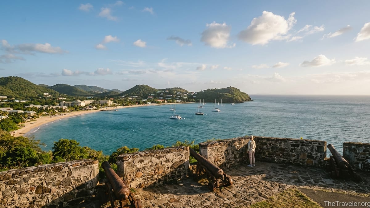
As you ascend toward Fort Rodney, you begin to see more substantial structures. The fort itself has thick stone walls, cannon emplacements overlooking Rodney Bay and the open Caribbean, and remnants of storage rooms tucked into the hillside. The atmosphere is surprisingly tranquil, especially in the early morning when there are few visitors and only the sound of wind and waves below. It is easy to imagine lookouts scanning the horizon for French sails or, later, American radio operators using the site during the Second World War.
Between Fort Rodney and Signal Peak, additional relics dot the ridge. Low walls and gun positions hint at the network of defenses that once ringed the island. The stonework is often weathered and partially overgrown, which makes for evocative photographs and encourages slow exploration. Children tend to enjoy peering through narrow openings in the walls like makeshift “spy holes,” while history buffs might linger over engravings on some of the information panels that detail specific naval battles watched from these heights.
Unlike larger Caribbean fortifications that have been heavily restored, Pigeon Island’s ruins retain a raw, slightly crumbling character. There are few barriers or roped-off zones, so visitors need to be mindful of loose stones, uneven thresholds and low walls when wandering around. Sensible footwear and attention to where you step are essential, particularly if you are tempted to back up quickly while composing a photo along the ramparts.
Viewpoints Over Rodney Bay and Best Photo Spots
From a photographer’s perspective, the Fort Rodney hike offers several distinct vantage points, each with its own mood. The classic view from the fort’s main cannon platform looks southwest across the turquoise water of Rodney Bay, with the marina’s masts and the curve of Reduit Beach in the distance. If you frame the cannon in the foreground and let the bay fill the background, you capture both the island’s military past and its modern resort life in one shot.
Higher up at Signal Peak, the panorama widens dramatically. On clear mornings, the horizon opens north toward Martinique, while looking back you can see Pigeon Island’s lower hill with Fort Rodney perched on top, framed by the deep blue of the Caribbean. Many visitors time their hike to reach this summit in the golden hour after sunrise or before sunset, when the low sun warms the color of the stone and softens the contrasts on the water. Those times also reduce the risk of haze that can flatten midday photos.
Closer to the base, there are more intimate compositions worth seeking out. Stone archways and doorways in the lower ruins make atmospheric frames for portraits, especially if a travel partner stands in the opening with the sea visible beyond. On the side of the island facing the open Atlantic, narrow paths lead to viewpoints where waves crash harder against darker rocks, creating a moodier contrast to the calm Rodney Bay side. Even if you are shooting with a smartphone, pausing here to let the auto-exposure settle on the bright water and then tapping on the stone foreground can help balance the scene.
For practical camera settings, treat Fort Rodney as a bright outdoor location with a mix of open sun and patchy shade. If you are using a mirrorless or DSLR camera with a standard zoom lens around 24 to 70 millimeters, shooting at f/8 will keep both cannons and coastline sharply in focus. Smartphone photographers can experiment with ultra-wide mode at the Signal Peak summit to emphasize the sweep of coastline, then switch to the regular lens for portraits among the ruins. A simple microfiber cloth is handy for wiping lenses, as sea spray and sweat can quickly smudge glass or phone screens.
Fort Rodney vs Signal Peak: Which Hike Is Right for You?
Understanding the differences between Fort Rodney and Signal Peak helps you match the hike to your fitness level and available time. Fort Rodney is the more accessible goal: a relatively short climb on established paths and steps, with rewarding views in multiple directions and engaging historical ruins. It suits most visitors who are comfortable with moderate hill walking, including many families with children or older travelers who are steady on stairs.
Signal Peak, by contrast, feels more like a small adventure. The path beyond the fort is less manicured, with loose rocks, uneven surfaces and at least a few sections where you will likely use your hands for balance. There are no railings near the top, and the exposure to sun and wind is greater. However, the reward is a genuinely expansive view that includes the curve of Saint Lucia’s northern coastline, the sweep of Rodney Bay, and, in good conditions, the outline of Martinique across the channel. Hikers who enjoy a slightly tougher effort and do not have serious knee or balance issues generally find this extension very satisfying.
If you are visiting with a mixed group, you can easily split your plans. For example, one part of the group might prefer to relax on the beach or explore the lower ruins and grassy picnic areas, while others climb to Fort Rodney. From there, a few more adventurous people could continue to Signal Peak while the rest linger around the cannons and viewpoints. Because the trails are short and well defined, regrouping back at the base or at the small beach bar is straightforward.
Time of day can also influence your choice. In the cooler early morning, both Fort Rodney and Signal Peak feel manageable for most active travelers. Under the full midday sun, some visitors choose to stop at the fort and save Signal Peak for another visit. If you are unsure, climb to Fort Rodney first, gauge how you feel on its steps and exposed sections, and then decide whether to tackle the steeper upper trail.
Practical Planning: Entrance, Timing and What to Bring
Pigeon Island National Landmark charges an entrance fee at the gate, with a different rate for visitors and local residents and reduced prices for children. As of recent seasons, travelers commonly report paying a modest amount roughly equivalent to a mid-range museum ticket in North America, with the option to use local Eastern Caribbean dollars or major credit cards. Fee structures can change, so it is worth checking with your hotel reception or a local tourism office shortly before you go for the most current information and exact opening hours.
The park typically opens in the morning and closes in the late afternoon. Many resort guests time their visit to start around 8:30 or 9:00 a.m., enjoying the hike in relative coolness and returning to their hotel by lunchtime. Cruise passengers docking in Castries often hire a taxi for a half-day excursion that combines Pigeon Island with a stop in Rodney Bay for shopping or lunch. From central Castries, the drive to the park usually takes about 25 to 35 minutes depending on traffic.
In terms of what to bring, think in terms of a light half-day outing rather than a full expedition. Comfortable closed shoes, one to two bottles of water per person, sunscreen, a hat and sunglasses are the essentials. Many travelers also carry a compact travel towel for a quick swim afterwards, a change of shirt if they expect to sweat heavily on the climb, and a small amount of cash for drinks or snacks at the beachside bar. A basic first-aid item like blister plasters can be surprisingly useful if you are wearing shoes that are not yet fully broken in.
Families with small children might consider a child carrier backpack instead of a stroller, as the steps and rough paths make wheeled access difficult beyond the lower lawns. Travelers with limited mobility may still enjoy the flat areas near the entrance, the museum and the first beach without attempting the climbs. Because shaded spots along the trails are limited, it is also wise for everyone to watch for early signs of heat fatigue and turn back if anyone begins to feel lightheaded or unusually short of breath.
The Takeaway
The Fort Rodney hike at Pigeon Island offers an unusually rich blend of accessible walking, far-reaching views and tangible history in a compact, easy-to-reach setting. Within a morning or afternoon you can stroll from palm-fringed beaches to cannon-lined ramparts and on to a rocky summit, giving you a sense of Saint Lucia’s strategic past and its present-day appeal as a gentle hiking destination.
Whether you stop at the fort or continue to Signal Peak, the key to a rewarding visit is simple preparation. Choose sturdy closed shoes over flip flops, carry enough water, avoid the hottest hours when you can and give yourself permission to move slowly and enjoy the scenery. With those basics in place, Pigeon Island becomes far more than a pretty headland at the end of Rodney Bay. It turns into one of the island’s most memorable short hikes, with views and photographs that will likely define how you remember Saint Lucia’s north coast.
FAQ
Q1. How long does it take to hike to Fort Rodney and Signal Peak?
The walk from the park entrance to Fort Rodney usually takes about 20 to 30 minutes each way at a relaxed pace, while continuing from the fort to Signal Peak adds another 15 to 25 minutes round trip. Allow 60 to 90 minutes in total for both summits, plus extra time for photos and rest stops.
Q2. How difficult is the Fort Rodney hike?
The Fort Rodney hike is short to moderate in length but involves a steady uphill climb on stone and wooden steps, some of which are high and uneven. Most reasonably fit visitors manage it comfortably by taking brief breaks, but those with knee problems or limited mobility may find the stair sections challenging.
Q3. Is Signal Peak much harder than Fort Rodney?
Yes, Signal Peak is noticeably more demanding. Beyond Fort Rodney the path is narrower and rockier, with some short scramble sections where you might use your hands for balance. The climb is still relatively short but feels steeper and more exposed to sun and wind than the fort trail.
Q4. What kind of shoes should I wear for the hike?
Closed-toe footwear with good grip is strongly recommended. Lightweight trainers, running shoes or simple hiking shoes are ideal. Flip flops, thin sandals and soft water shoes make the rocky steps and uneven ground more slippery and uncomfortable, especially on the descent.
Q5. When is the best time of day to hike Pigeon Island?
Early morning and late afternoon are the most comfortable times, with cooler temperatures, softer light for photography and often fewer visitors. Midday can be very hot and bright, so if you hike then, plan extra water, take more breaks in the shade and consider stopping at Fort Rodney instead of continuing to Signal Peak.
Q6. Is there shade on the trail?
There are some shaded stretches, especially lower down among shrubs and small trees, but key sections near Fort Rodney and most of the Signal Peak route are exposed. You should expect a mix of sun and patchy shade and come prepared with a hat, sunscreen and enough water.
Q7. Can children and older travelers do the Fort Rodney hike?
Many families and older travelers successfully reach Fort Rodney, provided they are comfortable with stairs and set a gentle pace. Young children may need help on the higher steps, and those with significant knee or balance issues should consider enjoying the lower ruins and beaches instead of attempting the full climb.
Q8. Are there restrooms, food and water available inside the park?
Restrooms are located near the entrance area, and there is typically a casual beach bar or small snack outlet operating near the first beach. However, opening times and offerings can vary, so it is wise to arrive with your own water and any essential snacks rather than relying entirely on on-site vendors.
Q9. Do I need a guide for Fort Rodney and Signal Peak?
You do not normally need a guide, as the main paths are short and straightforward, with clear starting points near the central lawns and ruins. Independent visitors commonly hike both Fort Rodney and Signal Peak on their own. A guide can add historical context, but for basic navigation most travelers manage well with the park map and on-site signs.
Q10. Can I swim or relax on the beach after the hike?
Yes, one of the advantages of Pigeon Island is the easy access to small sandy beaches at the base of the hills. Many visitors finish the hike with a swim in the calm water of Rodney Bay or relax under the trees with a drink from the nearby bar, combining a short climb with beach time in a single outing.