


Pigeon Island National Landmark is one of Saint Lucia’s defining places: a compact headland of dry forest, golden coves and volcanic rock where crumbling stone barracks and iron cannons still look out to sea. Once a strategic British naval base and now managed by the Saint Lucia National Trust, this protected site offers visitors a rare mix of Caribbean beach time and tangible military history, all framed by views that stretch from Rodney Bay to the distant outline of Martinique on clear days.
Get the latest updates straight to your inbox!
Why Pigeon Island Matters to Saint Lucia
Pigeon Island sits off Saint Lucia’s northwest tip, now linked to the mainland by a man-made causeway that also forms the popular Rodney Bay area. Covering roughly 40 to 44 acres, it is relatively small, but locals and historians often describe it as one of the country’s most important historic monuments. The site is officially managed as a national landmark by the Saint Lucia National Trust, which oversees both its cultural relics and its fragile dry coastal ecosystem.
The island’s position between the open Atlantic and the calmer Caribbean Sea made it a coveted lookout point during the centuries-long struggle between Britain and France for control of Saint Lucia and the wider Windward Islands. From the higher ridge, British commanders could watch the French fleet based in Martinique and control access to the sheltered bay that is now lined with resorts and marinas. That same commanding geography now rewards visitors with some of the best viewpoints on the island.
For modern Saint Lucia, Pigeon Island is more than a scenic park. It is a focal point for national events and festivals, including major concerts and, in some years, performances associated with the Saint Lucia Jazz & Arts scene. Families from nearby Gros Islet buy day passes for picnics on the lawns, school groups visit to learn about colonial history, and cruise-ship passengers come ashore for a half-day of hiking and swimming. For many visitors, a day at Pigeon Island becomes the moment when the island’s history, landscape and present-day culture all come into focus.
A Short History: From Pirates to Admiral Rodney
Long before official forts and stone barracks rose on Pigeon Island, the headland was associated with privateers. Local lore links it to the sixteenth-century French corsair François Le Clerc, sometimes called Jambe de Bois or Wooden Leg, who reportedly used the rocky outcrop and nearby caves as a base for raiding Spanish shipping routes. While the details are clouded by legend, it is easy to imagine how the island’s hidden coves and clear views of passing vessels would have suited a pirate crew.
Control of Saint Lucia repeatedly changed hands between France and Britain in the seventeenth and eighteenth centuries, and Pigeon Island gradually took on more formal military significance. By the late 1700s, when British Admiral George Rodney focused on the region, the headland was recognized as a key site for monitoring French naval movements out of Martinique. Rodney had lookout posts established on the island so his officers could signal the approach of enemy ships. From what is now known as Signal Peak, observers could watch the sea lanes between the islands, and that intelligence fed into British strategy during the Caribbean campaigns of the American Revolutionary era.
In the nineteenth and early twentieth centuries the site’s military role diminished, and Pigeon Island’s strategic isolation was eroded when a stone causeway was completed in the early 1970s, connecting it permanently to the mainland near Gros Islet. In 1979, the area became a national park, and in 1992 it was formally designated a national landmark under the stewardship of the Saint Lucia National Trust. Today, interpretive signs, a small museum and guided tours help visitors connect the remaining fortifications, barracks and gun batteries to the broader story of Saint Lucia’s colonial past.
Exploring Fort Rodney, Ruins and Cannons
The centerpiece of Pigeon Island’s built heritage is Fort Rodney, an eighteenth-century British fortification perched on one of the site’s main hills. Reaching the fort takes most visitors around 10 to 20 minutes on foot from the main lawn, following a dirt and stone path that climbs through scrub vegetation. The route is short but can feel steep in the midday heat, so many travelers tackle it early in the morning or late in the afternoon, carrying water and wearing closed shoes rather than beach sandals.
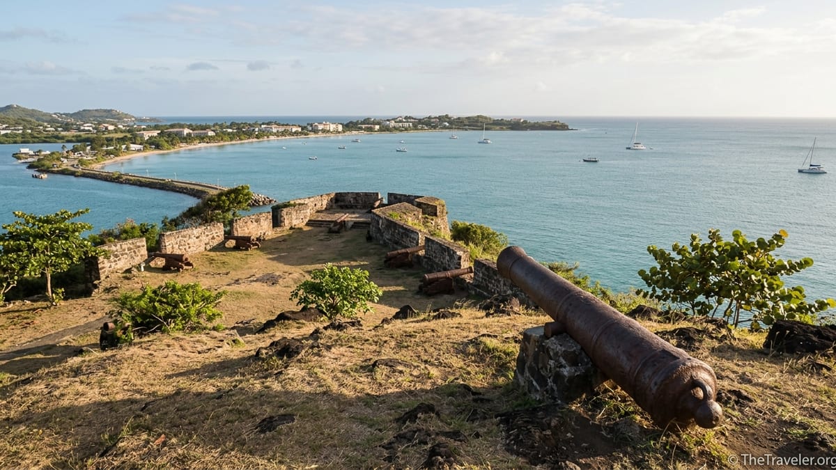
At the top, the stone walls and grassy terraces of Fort Rodney frame wide views over Rodney Bay, the arc of Reduit Beach and the northwestern coastline. Several cannons remain pointed out towards the sea, their barrels rusted and carriage wheels long gone. Children often scramble around them for photos, and local guides use them as visual aids when explaining how British forces once tried to control these waters. On very clear days, visitors sometimes report glimpsing the silhouette of Martinique on the northern horizon, which helps bring Admiral Rodney’s long-distance watch strategy into focus.
Below and around the fort, you can wander through the remains of officers’ quarters, stone cisterns and crumbling outbuildings. Some walls are thick with lichens and small cacti, a reminder that Pigeon Island lies in one of Saint Lucia’s drier microclimates. Interpretive panels in English outline what each ruin likely contained, from gunpowder storage to mess halls. Independent travelers often spend an hour or more circling among these structures, pausing under almond trees or casuarinas for shade while they piece together the everyday routines of the soldiers who once lived here.
Museum, Interpretation Centre and Living Heritage
Near the entrance and main lawn, visitors will find a modest museum and interpretation centre that provides helpful context before or after climbing to Fort Rodney and Signal Peak. Exhibits typically cover the island’s transition from a small offshore outpost to a fortified base, with period maps, reproductions of military documents and displays that show how the Saint Lucia National Trust manages the site today. Travelers who have visited other Caribbean forts often remark that this museum, though small, makes the Pigeon Island story feel vivid and specific to Saint Lucia rather than just another generic colonial ruin.
Practical details for the museum can vary by season, but it is generally open on weekdays during regular park hours. Many recent visitors note that the rooms are air-conditioned, which makes them a welcome stop after time on the trails. Because artifacts on display are limited, it is worth taking a slow lap around and reading the panels, especially those that explain the significance of Pigeon Island in regional conflicts and the later environmental work to restore its native vegetation.
The landmark also serves as a living cultural space. Saint Lucian school groups routinely use the lawns for educational outings, and in past years the site has hosted major music performances and public celebrations. During festival periods, temporary stages, food vendors and art stalls appear inside the park, and admission procedures may change slightly to accommodate event ticketing. Travelers who visit outside those peak times experience a quieter, more contemplative atmosphere, hearing only the wind in the trees and the sound of waves on the rocky shoreline.
Trails, Viewpoints and Wildlife
The trail network at Pigeon Island is relatively simple but rewards unhurried exploration. From the central lawn, short paths branch off towards Fort Rodney, Signal Peak, the northern ridge and the coastal perimeter. Most are unpaved, consisting of packed earth, rocks and occasional stone steps. Visitors in typical resort flip-flops can manage the lower sections, but anyone intent on reaching the highest viewpoints will be more comfortable in sneakers or light hiking shoes, as loose gravel and exposed roots are common.
Signal Peak, the site’s highest point, offers a 360-degree panorama of Saint Lucia’s northern tip. The ascent from the Fort Rodney saddle takes around 10 additional minutes and is steeper, with some sections where travelers use handrails or rock outcrops for balance. In return, the summit delivers some of the island’s most memorable views: the curve of Rodney Bay below, the spread of Gros Islet and, on clear days, distant mountain ridges further south. Sunset hikes are popular, but visitors should remember that the paths are unlit after dark; planning to be back on the main lawn before full nightfall is advisable.
Despite its history as a military outpost, Pigeon Island is also an important refuge for coastal vegetation and wildlife. Dry scrub forest and sea-grape thickets shelter lizards, small birds and, occasionally, nesting seabirds on the more secluded edges. Travelers frequently report sightings of hummingbirds, bananaquits and other Caribbean species flitting among flowering shrubs near the trails. The rocky shoreline, especially around the northern and eastern edges, can be a good place to spot crabs and tide-pool life at low tide, although strong swells mean it is best enjoyed from a safe distance rather than as a swimming area.
Beaches, Swimming and Relaxing on the Coast
One of the main draws for many visitors is that Pigeon Island combines accessible history with easy beach time. Within the landmark’s boundaries are small, calm coves with sandy entries and typically gentle water, especially on the Caribbean-facing side. Families with younger children often set up here for the day, spreading towels on the sand or renting chairs provided by local vendors when available. Compared with busier beaches such as nearby Reduit Beach, the coves inside the landmark feel more secluded and framed by low headlands rather than large hotels.
The clarity of the water around Pigeon Island varies with weather and wave conditions, but on calm days it is clear enough for casual snorkeling along the rocks. Travelers sometimes bring their own masks and fins from resorts in Rodney Bay or purchase inexpensive sets at local shops before arriving. While this is not a world-famous coral site, the rocky edges can reveal small fish and bits of sea grass habitat, and the experience of floating below the historic ramparts appeals to many visitors.
Facilities inside the park support a relaxed beach day. There are basic washrooms near the entrance, shaded picnic tables on the lawns and, at times, a small café or bar operating close to the main beach area where you might find cold drinks and simple meals like grilled fish, burgers or local roti. Outside the landmark, along the causeway, separate public beaches and resort areas offer additional options for jet-ski rentals, catamaran trips and waterfront restaurants, making it easy to combine a morning of history and hiking with an afternoon of more conventional resort activities.
Planning Your Visit: Hours, Entry and Guided Tours
Pigeon Island National Landmark typically opens during standard daytime hours, with last entry in the late afternoon to allow visitors enough time to explore before closing. Recent schedules advertised by the Saint Lucia National Trust indicate that ticket sales usually stop around 4:15 pm, though travelers should check locally for any seasonal changes or special event closures. Arriving by late morning or early afternoon gives ample time to walk the trails, tour the museum and enjoy a swim before the site winds down.
The landmark charges an admission fee, with separate rates for adults and children and discounts for residents. Prices are modest by international standards and are subject to periodic revision, so it is safest to budget a small per-person fee in addition to transport. Many hotels in Rodney Bay and Gros Islet can advise on current rates and, in some cases, bundle entrance into half-day excursions or island tours. Visitors arriving independently by taxi from resort areas typically pay a short metered or negotiated fare, while those staying nearby often choose to walk to the causeway and access the gate on foot.
Guided tours are available and can add real value for travelers interested in understanding the military architecture, the broader colonial context and the island’s flora. The Saint Lucia National Trust periodically offers official guided walks that follow a loose circuit from the entrance through the ruins and up to Fort Rodney, with commentary along the way. Independent local guides may also be present at the gate or bookable through tour desks in Rodney Bay. For a deeper experience, especially if you have limited time, joining one of these small-group walks can help you interpret structures that might otherwise appear as anonymous stone walls.
Because shade is limited on the higher trails and stone surfaces reflect heat, practical preparation matters. Visitors often pack sunscreen, hats, refillable water bottles and light clothing that covers shoulders. Closed footwear is recommended for the climbs, though many people carry sandals in a bag for later beach time. Those with mobility challenges can still enjoy the lower lawns, museum area and beach coves, even if the steeper paths to Fort Rodney and Signal Peak are not accessible.
Connecting Pigeon Island With the Rest of Saint Lucia
Geographically, Pigeon Island forms the northern edge of Rodney Bay, one of Saint Lucia’s best-known resort zones. Many travelers base themselves at hotels and guesthouses in Reduit Beach, Gros Islet or the marina area and then set aside a half or full day to explore the landmark. From those bases, taxi rides are usually short, and some visitors opt to rent kayaks or join small-boat excursions that approach the island from the water, offering views of the fortifications from sea level before landing near the entrance.
Combining the landmark with nearby attractions makes for a rewarding day. A common pattern is to visit Pigeon Island in the morning, hike to the viewpoints while temperatures are relatively cool, then return to Rodney Bay village for a late lunch at one of the open-air restaurants overlooking the marina. From there, travelers might continue on to Friday night festivities in Gros Islet if they happen to be visiting over the weekend, or book a sunset cruise that sails past the headland they walked earlier in the day.
For visitors circumnavigating the island on longer trips, Pigeon Island provides a useful counterpoint to the lush slopes and volcanic shoreline further south near Soufrière and the Pitons. Here, the landscape is drier, the military history more prominent and the views oriented towards the northern channel rather than the famous twin peaks. Experiencing both regions in one trip gives a fuller sense of Saint Lucia’s varied geography and the different ways its environment has shaped human activity.
The Takeaway
Pigeon Island National Landmark occupies a small footprint, but it distills much of what makes Saint Lucia compelling: layered history, striking coastal scenery and a relaxed contemporary rhythm. Within a few hours, visitors can trace the outlines of an eighteenth-century fort, read about naval maneuvers that once decided the fate of empires, then swim in quiet coves beneath the same headlands that served as lookout points centuries ago.
For travelers who want more from their beach holiday than sunloungers and cocktails, Pigeon Island offers an accessible way to connect with the island’s past and present. Thoughtful interpretation, well-maintained trails and the simple pleasure of sitting on a grassy ridge watching boats cross Rodney Bay all combine to leave a lasting impression. Whether you visit on a quick cruise stop or as part of a longer stay in Saint Lucia, setting aside time for this national landmark deepens your understanding of the island beyond its postcard views.
FAQ
Q1. Where is Pigeon Island National Landmark located in Saint Lucia?
Pigeon Island National Landmark is on Saint Lucia’s northwest coast, forming the northern edge of Rodney Bay and connected to the mainland by a causeway near Gros Islet.
Q2. How much time should I plan to spend at Pigeon Island?
Most visitors are comfortable with three to four hours, which allows time to hike to Fort Rodney, visit the museum, wander the ruins and enjoy a swim at the beaches.
Q3. Is the hike to Fort Rodney suitable for children and older travelers?
The hike is short but includes some steep, uneven sections. Active children and reasonably fit older travelers usually manage it with care, sturdy footwear and regular rest stops.
Q4. Are there food and drink options inside the landmark?
Services can vary, but there is often a small café or bar near the main beach offering snacks and cold drinks. Many visitors also bring their own water and simple picnic items.
Q5. Can I swim and snorkel at Pigeon Island?
Yes. The small coves on the Caribbean-facing side are popular for swimming, and on calm days basic snorkeling along the rocky edges can reveal small fish and underwater life.
Q6. Do I need a guided tour to enjoy the site?
No, you can explore on your own using the marked paths and signs. However, guided tours offered by the Saint Lucia National Trust or local guides provide richer historical and ecological context.
Q7. What should I wear and bring for a visit?
Light clothing, a hat, sunscreen, and comfortable closed shoes for the trails are recommended, along with swimwear, a towel and plenty of drinking water, especially in the hotter months.
Q8. Is Pigeon Island accessible by public transport?
There is limited direct public transport to the entrance. Most visitors arrive by taxi, organized tour or on foot from nearby Rodney Bay and Gros Islet along the causeway.
Q9. Are there facilities such as restrooms and changing areas?
Yes. Basic restrooms are available near the entrance and main lawn, and many visitors use them as informal changing areas before or after swimming at the beaches.
Q10. Is Pigeon Island National Landmark suitable for visitors with limited mobility?
The steeper paths to Fort Rodney and Signal Peak are challenging, but the lower lawns, museum area and beach coves are more accessible, so visitors with limited mobility can still enjoy parts of the site.