


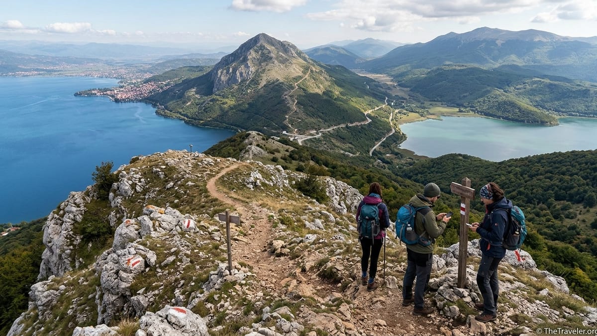
High above the blue expanse of Lake Ohrid and the quieter shores of Lake Prespa, Galičica National Park offers some of North Macedonia’s most memorable hiking. The park’s ridge delivers double-lake panoramas, breezy alpine meadows and exposed peaks that demand respect for weather and altitude. This guide focuses on verified trails and current access rules to help you choose between the celebrated Magaro summit route and easier walks starting near Korita, Velestovo and other official trailheads.
Get the latest updates straight to your inbox!
Understanding Galičica’s Official Trail System
Galičica National Park spans the mountain ridge between Lake Ohrid and Lake Prespa, with a signed trail network of around 200 kilometers according to the park’s management plan. The official system groups routes into short out-and-back walks, full-day trails and multi-day crossings that link visitor centers, traditional villages and high viewpoints. These marked paths are designed to keep visitors away from the most sensitive wildlife habitats while still reaching standout panoramas.
The management plan lists named routes such as Velestovo – Velestovski Korita, Konjsko – Sveti Ilija, Trpejca – Mal Osoj – Derven – Rampa – Ušine – Ljubanista, and the higher Bába – Magaro and Bába – Lako Signoj sections. These are the backbone for much of the hiking sold by local guides and tour agencies. Trailheads are usually reachable from lakeside villages by a mix of asphalt and gravel roads, then follow painted markers through beech forest, scrub and open karst terrain.
While private blogs and generic hiking sites often give rough descriptions, the park authority and regional hiking clubs base their distance, elevation and difficulty ratings on field surveys. As a result, it pays to cross-check informal online tracks against park information boards, the official Galičica mobile app and recent route notes from local mountaineering societies, especially if you plan shoulder-season hikes when snow patches and muddy sections can still affect timing.
Visitors should think in terms of vertical gain rather than just horizontal distance. Even shorter walks often involve altitude differences of several hundred meters between lake level and the first open viewpoints, and high routes on the main ridge stay above 1,800 meters for long stretches. This means that weather, fitness and footwear matter more here than on an easy lakeside promenade in Ohrid.
Magaro Summit vs Easier Korita and Velestovo Walks
The most famous route in Galičica is the ascent of Magaro, the park’s highest peak at approximately 2,255 meters. The standard line starts from the Lipova Voda pass on the mountain road, around 1,600 meters above sea level. From here, a well-marked trail climbs through forest to the open ridge and follows it over undulating ground to the summit. Hiking clubs that use this route report a total elevation gain of roughly 650 meters, with a typical ascent and descent time of 4 to 5 hours for a fit, acclimatized group.
In good summer weather Magaro is a non-technical mountain walk rather than a climb, but it is significantly more demanding than lower park trails. Above the treeline hikers are fully exposed to sun, wind and any passing storms, with no water sources along the way. The reward for the effort is one of the Balkans’ classic viewpoints: on clear days, Lake Ohrid stretches below to the west while Lake Prespa appears to the east, framed by the Baba and Pelister ranges in the distance.
By contrast, routes around Velestovo and the Korita meadows are far gentler, making them better half-day choices for less experienced walkers. From the Velestovo trailhead above Ohrid, a marked path leads through mixed forest and past traditional summer grazing areas to the natural amphitheater known as Velestovski Korita. The elevation gain here is more modest, often in the range of 300 to 400 meters depending on the exact variant, and hiking times typically run to 2 to 3 hours return. The views focus more on the Ohrid side of the park, with sweeping looks back toward the town and its bay rather than both lakes.
Another accessible option begins near Trpejca or from short-road spurs signposted to viewpoints above the village. While these paths are still classed as mountain walking and require proper footwear, they lack the prolonged high-altitude exposure of Magaro. Families or visitors unsure about their fitness can use these lower trails to experience Galičica’s limestone scenery and lake panoramas without committing to a full ridge traverse.
Key Routes: Kota 10 – Magaro, Velestovo – Elen Vrv and Alternatives
Among the park’s published high routes, the Kota 10 – Magaro line is often highlighted. It links a signed point on the ridge, sometimes referred to as Kota 10 in local mapping, with the Magaro summit. Walking this full section involves moving along a narrow, often windswept crest with prolonged exposure on both sides. Distance varies depending on whether you treat Lipova Voda or another pass point as your start, but hikers should plan for a solid full day with cumulative elevation gains and losses exceeding the simple lake-to-summit figures.
The Velestovo – Elen Vrv route is another officially described trail that offers a bridge between mid-mountain forest and higher viewpoints. Starting from Velestovo village above Ohrid, it climbs toward the Elen Vrv area on the western flank of Galičica. While exact figures differ by variant, hikers can expect several hundred meters of ascent, with longer options reaching 800 to 1,000 meters of total gain if you continue toward the ridge. The trail is waymarked and widely used by local outdoor clubs, but sections can be rocky, and snow or wet leaves can linger into spring, slowing progress.
For visitors who want marked trails but shorter days, the park’s management plan lists a series of “short routes” such as Velestovo – Velestovski Korita, Konjsko – Sveti Ilija or Trpejca – Čokolsko. These generally last 1.5 to 3 hours round trip, stick closer to treeline and offer partial panoramas from clearings or small knolls. Although easier, they still qualify as mountain hikes rather than casual strolls, with occasional steep pitches, loose stones and simple waymarking instead of manicured paths.
When planning any of these routes, treat park time estimates as a baseline for experienced walkers. If you or your group are not regular hikers, add a generous buffer for rest stops, photos and slower sections. For example, a local hiking club might list Magaro from Lipova Voda as a 4-hour climb and descent, but many independent visitors will be more comfortable planning on 5 to 6 hours, especially in midsummer heat.
Reaching Trailheads: The Galičica Road, Closures and Transport
The mountain road that crosses Galičica between Lake Ohrid and Lake Prespa is central to accessing many trailheads, including the Lipova Voda start for Magaro. Regional travel guides and recent trip reports agree that this pass road is typically open from around mid-April to late autumn, with closure often in late November or early December when snow and ice make conditions unsafe. One detailed itinerary for southwest Macedonia noted a closure in the first week of December and a reopening on 17 April in a recent year, which is a realistic pattern for planning.
Road conditions on the pass are generally good asphalt with tight switchbacks, but drivers must be prepared for steep gradients, unguarded edges and the need to use low gears. The reward is a celebrated panorama from near the top where both Lake Ohrid and Lake Prespa come into view. Several paved lay-bys and small parking areas exist close to the high point and near trailheads such as Lipova Voda and unofficial viewpoints signposted from the main road.
There is no regular public transport crossing Galičica. Buses around Lake Ohrid will take you as far as lakeside villages such as Peštani, Trpejca or Sveti Naum, but not over the ridge to Prespa nor up to the higher access points. Regional guides and local taxi services concur that a rental car, a pre-booked taxi or an organized tour is necessary if you want to reach Magaro, the main pass viewpoints or trailheads far above the shore.
From Ohrid, taxi companies advertise day trips into Galičica, often quoting a flat rate in euros for a return journey with waiting time at the pass. Exact prices fluctuate, but travelers report paying in the region of 20 to 30 euros one way to the high road, with negotiation depending on season and waiting time. For independent hikers without a car, a practical arrangement is to hire a taxi in Ohrid to drop you at Lipova Voda in the morning and either wait for your return from Magaro or arrange a fixed pickup time later in the day.
Tickets, Fees and What Your Dinars Cover
Galičica National Park charges an entrance fee for visitors using its trails and facilities. As of mid-2025, the park’s official online ticket shop lists a general single-entry ticket at 100 Macedonian denars per person, usually applied to day visitors over a certain age threshold. This ticket covers regular access to the park for standard hikes and viewpoints that do not involve the highest peak routes.
In addition, the park has introduced a specific product for the Magaro area. The same official ticket list shows a separate 300-denar per-person fee for “Stara Galičica Peak Magaro,” sometimes described by mountain organizations as a “peak fee.” This charge applies when you intend to climb to the Magaro summit rather than simply driving the pass or using lower trails. Visitors planning the classic Lipova Voda – Magaro hike should therefore budget for both the general park admission and the peak-specific ticket if required by rangers on the day.
There are indications from earlier visitor reports and regional blogs that vehicle entry charges may also be levied for cars driven into the park, with figures in the past around the equivalent of a few euros. However, up-to-date, detailed vehicle tariffs are not clearly published in English. At the entrance checkpoint, rangers typically ask about the purpose of your visit and calculate the total based on people, vehicles and specific activities such as paragliding launches or access to Golem Grad in Lake Prespa.
Because local practice can shift slightly from season to season, hikers should carry cash in Macedonian denars and expect to pay per person for access, with a higher rate if they are heading for Magaro. If you are visiting only roadside viewpoints near the pass without undertaking the summit hike, the standard 100-denar ticket is likely to be sufficient, but you should follow the current instructions from park staff at the entrance barrier or visitor centers.
Weather, Altitude and Safety on the Ridge
Magaro’s summit at around 2,255 meters may not sound extreme compared with the highest Balkan peaks, but the combination of altitude, exposure and rapidly changing weather deserves serious preparation. The ridge routes have long stretches with no shelter and minimal vegetation, meaning that strong winds, sudden temperature drops and electrical storms can all become hazards within minutes. Summer afternoons often see building cumulonimbus clouds over the lakes, bringing lightning and short but intense downpours.
Snow can remain on shaded slopes and in hollows into late spring, particularly on the Prespa side of the ridge. In April and even early May, this can translate into slippery traverses, hidden holes and cornices near the crest. In autumn, cold fronts can bring the first dustings of snow while the lakeshores still feel mild. Hikers tackling Magaro in shoulder seasons should pay close attention to forecasts, be prepared to turn back at the first signs of deteriorating conditions and consider hiring a local guide if they are not used to reading mountain weather.
Navigation also becomes more challenging in poor visibility. While the main park trails are marked with standard paint blazes and occasional signposts, fog and low cloud can easily obscure both markers and landmarks on the karst plateau. GPS-based offline maps on a phone or handheld device are extremely useful in such conditions but are not a substitute for judgment. Parts of the ridge have intermittent or weak mobile reception, especially on the Prespa side, which limits reliance on live mapping or calls for help.
Water availability is limited on most high routes. There are no reliable springs on the main crest between Lipova Voda and Magaro, and livestock troughs on some lower meadows are not recommended drinking sources without proper treatment. Hikers should start with enough water for their full planned duration plus a margin for delays, particularly in midsummer when exposed sections can feel significantly hotter than the air temperature suggests.
Suggested Itineraries: Half-Day Viewpoints, Full-Day Summit and Easy Alternatives
For a realistic half-day viewpoint excursion with strong scenery but moderate effort, consider a hike from a mid-mountain trailhead such as Velestovo to the Korita meadows. Driving or taking a taxi from Ohrid up the narrow road to Velestovo saves much of the initial ascent from lake level. From the village, follow the official Velestovo – Velestovski Korita route through forest and past traditional grazing areas to the open bowl above. With an elevation gain in the region of 300 to 400 meters and a walking time of roughly 2 to 3 hours return, this outing suits reasonably fit visitors who want expansive views toward Lake Ohrid without spending a full day on the ridge.
A classic full-day summit hike centers on Magaro from Lipova Voda. Start early from Ohrid or Trpejca to reach the pass before mid-morning, pay the appropriate park and Magaro fees at the checkpoint if requested, then set off on the marked trail through beech forest. Plan on 5 to 6 hours of hiking time including rest stops and photos, with around 650 meters of elevation gain. On clear days, aim to reach the summit before early afternoon to reduce the risk of encountering summer thunderstorms. Return the same way to Lipova Voda and meet your waiting taxi or drive back down to the lake.
As an easier alternative for families or visitors with limited hiking experience, use the Galičica road primarily for roadside panoramas combined with very short walks. From Ohrid or Trpejca, drive up to the main pass viewpoint where both lakes are visible and explore a few hundred meters along the signed path in each direction before turning back. This provides a taste of the ridge environment and wide views without committing to significant altitude gain or hourly time pressure. Travelers with children can combine this with swimming or a boat trip from Trpejca in the afternoon, keeping the day varied and manageable.
For guests staying on Lake Prespa, day hikes from villages such as Stenje can link lakeside chapels with gentle forest paths that remain below the highest crest. Official route lists mention Stenje – Presveta Bogorodica and Stenje – Konjsko – Stenje as shorter circuits on the Prespa side. These walks give quieter views across the lake and a different perspective on Galičica without requiring the long drive around via Resen to reach the Ohrid shore.
Where to Stay: Ohrid, Trpejca and Lakeside Villages
Most hikers base themselves in Ohrid, which has the widest choice of guesthouses, hotels and restaurants along with car rental desks and taxi companies familiar with Galičica transfers. From the old town or lakeside promenade, the drive to the park entrance above Peštani takes around 25 to 40 minutes in normal traffic, depending on where you are staying. This makes it feasible to set off early for Magaro or Velestovo while still enjoying evenings back in town.
Trpejca, a small fishing village on the southern shore of Lake Ohrid, offers a quieter alternative with a handful of guesthouses and waterfront eateries. Staying here places you closer to the road that climbs through Galičica, reducing the drive to the pass and cutting transfer times for summit days. However, services are more limited than in Ohrid, and arranging early-morning taxis may require advance coordination with local drivers or your accommodation host.
On the Prespa side, villages such as Stenje provide simple accommodation options and easy access to lakeside trails and viewpoints within the national park. This can be an appealing base if you are including Prespa and nearby Pelister National Park in a wider itinerary. The trade-off is that reaching well-known viewpoints on the Ohrid side or starting routes like Velestovo – Elen Vrv will involve a longer drive around the lake or over the pass when it is open.
Wherever you stay, factor in the extra travel time to trailheads and back when planning your hiking days. A nominal “4-hour hike” to Magaro can easily fill a full day once you add 60 to 90 minutes of return driving, time for paying fees at the park entrance, and delays at scenic stops along the pass road. For visitors with only one or two free days, staying in Ohrid or Trpejca typically offers the most efficient access to a variety of routes.
Equipment, Navigation, Costs and Accessibility
Even on shorter routes, treat Galičica as a genuine mountain environment. Sturdy trail shoes or hiking boots with good grip are advisable for rocky and sometimes slippery sections. Pack a light waterproof jacket, insulating layer, hat and sun protection, as well as enough water and high-energy snacks. Trekking poles can be very useful on steeper descents from Magaro or the ridge, especially for hikers with knee issues. For shoulder-season trips, consider adding thin gloves and a warm hat, as windchill on the crest can be sharp.
Offline navigation is strongly recommended. Before leaving Ohrid or Prespa, download maps for the area using a reliable app and ensure your phone is fully charged. While official paint markers and signposts exist on the main trails, winter weather, livestock and vegetation can obscure some waymarks. Having a digital track that matches an official route description helps confirm you are on the correct line, particularly in fog or near junctions.
In terms of budget, hikers in 2025 and 2026 should plan for at least 100 Macedonian denars per person for general park entry, plus an additional 300 denars each for Magaro access if climbing the peak. If you are driving your own or a rental car, be prepared for a possible vehicle fee at the gate, although the exact current tariff needs to be confirmed on arrival. Taxi transfers from Ohrid to the high pass and back often fall in the range equivalent to several tens of euros, varying with negotiation, season and waiting time. Organized group hikes with a licensed guide and transport will cost more but include logistics and local expertise.
Accessibility is limited for those with reduced mobility. The pass road itself offers excellent panoramas from the car or from very short walks on mostly level terrain at roadside pull-offs, which can suit visitors unable to tackle sustained mountain walking. However, almost all signed hiking routes involve uneven ground, roots, rocks and sometimes narrow paths with significant gradients. These are not suitable for wheelchairs or strollers, and there are no lift or cable car systems in the park.
Choosing the Right Trail: Hikers, Beginners and Photographers
For beginners with basic fitness who want a taste of Galičica without overreaching, the best starting points are the park road viewpoints near the main pass and shorter low-to-mid-level routes such as Velestovo – Velestovski Korita or Trpejca – Čokolsko. These provide satisfying views of Lake Ohrid, wildflower meadows and glimpses of the karst terrain within a half-day outing. Staying in Ohrid or Trpejca, arranging a taxi or driving your own rental to the trailhead, and keeping total hiking time to 2 to 3 hours is a realistic and rewarding plan.
Experienced hikers looking for a full-day challenge and the classic two-lake panorama should target the Magaro summit via Lipova Voda or a longer Kota 10 – Magaro ridge section. These routes demand solid fitness, comfort with sustained altitude above 2,000 meters and the ability to navigate in changing weather. The extra 300-denar peak fee is a worthwhile price for those spectacular summit views, but you should only commit if forecasts are stable and you are properly equipped for exposed conditions.
Visitors primarily interested in photography have two main strategies. The first is a road-based itinerary using the Galičica pass, stopping at high lay-bys and chapels with clear views of both lakes. This minimizes walking but still delivers dramatic wide-angle scenes suitable for sunrise and sunset shoots. The second is to pair a moderate hike such as Velestovo – Korita or a section of Velestovo – Elen Vrv with early or late light, capturing side-lit slopes, traditional villages and glittering lake surfaces from slightly higher vantage points.
Whichever option you choose, approach Galičica with the mindset of a mountain traveler rather than a casual tourist. Check current road opening dates, confirm ticket requirements, carry appropriate gear and allow generous margins for weather and transport. Treated with respect, the park’s ridges, forests and lakeside spurs will reward you with some of the most memorable views in North Macedonia.