
More news on this day
More heavy rain is expected on Saturday across parts of the United States, with saturated ground and poor drainage combining to raise the risk of street flooding in several urban corridors popular with summer travelers.
Get the latest news straight to your inbox!
Storm Setup Points to Another Soaking Saturday
Weather outlooks for this weekend indicate that a slow moving frontal boundary and a deep supply of Gulf and Atlantic moisture will converge on parts of the eastern and southern United States on Saturday. The pattern is expected to produce widespread showers and embedded thunderstorms, many capable of brief but intense downpours over already wet ground.
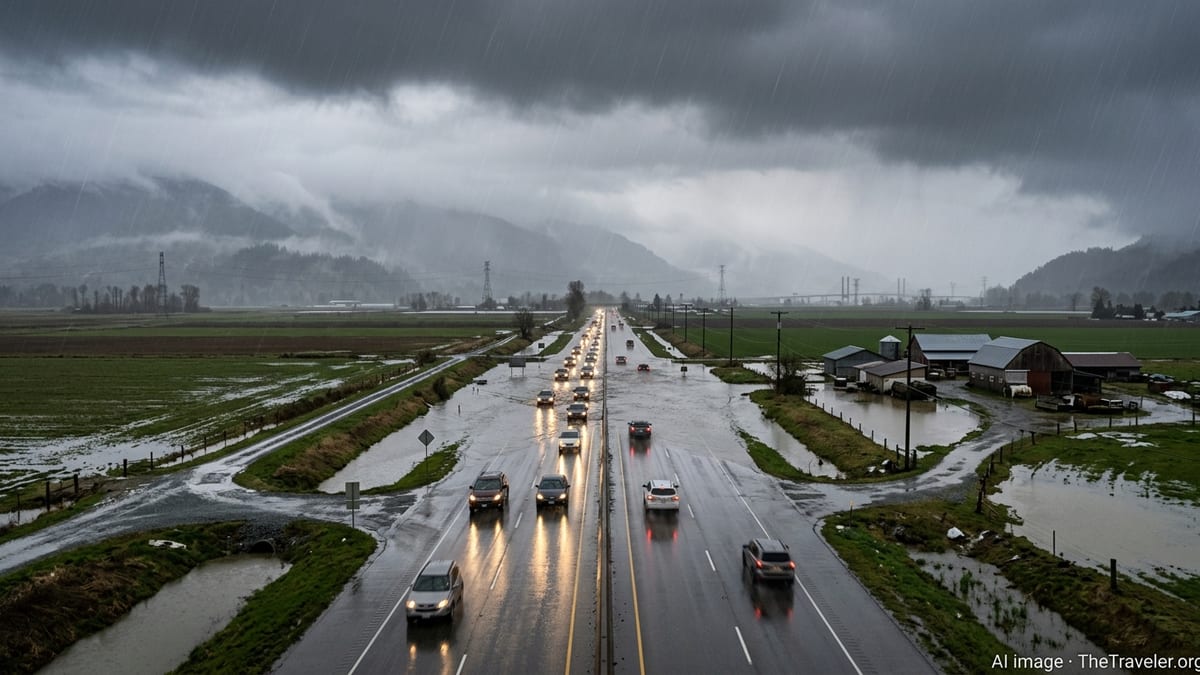
Recent rainfall over the past several days has left soils saturated in many locations, reducing the ability of the ground to absorb additional water. When new storms develop under these conditions, runoff tends to flow rapidly into streets, creeks, and low lying areas instead of soaking in, increasing the chances of quick hitting flooding in heavily paved neighborhoods and business districts.
Publicly available forecast discussions describe an environment with high humidity, unstable air, and weak steering winds. Those ingredients often lead to slow moving or repeatedly developing storms, a setup that can focus heavy rain over the same city blocks for an hour or more. Even where rainfall totals for the day are moderate, a single intense cell over an urban core can be enough to overwhelm drainage systems.
Travelers planning weekend drives or short haul flights through major hubs in the Mid Atlantic and Southeast may encounter slower traffic, ponding on interstates, and localized disruption to ground operations at airports during the strongest storms. Conditions will vary by region, but the broader pattern points to an unsettled day for many popular summer routes.
Street Flooding Threat Focused on Urban Corridors
The greatest concern on Saturday centers on street flooding in dense urban corridors, where a combination of paved surfaces, aging drainage, and recent heavy rain can turn a brief downpour into travel headaches within minutes. Public forecast products highlight particular vulnerability in low lying neighborhoods, underpasses, and intersections that routinely collect water during strong storms.
Urban flooding of this type typically develops faster than river flooding, sometimes within the lifespan of a single thunderstorm. Water can quickly cover lanes on major roads, conceal potholes and debris, and back up into parking lots. In tourist districts, popular waterfront promenades and entertainment zones near rivers or bays can see fast rises in standing water when a storm coincides with high tide.
Reports from recent rain events this week describe instances of curb to curb water coverage on secondary roads, as well as temporary closures on smaller bridges and tunnels where drainage grates clogged with debris. With similar or greater rainfall possible on Saturday, those same weak points in the transportation network are likely to be tested again.
For visitors staying in city center hotels, the practical effect may be short but disruptive bursts of heavy rain that temporarily limit movement on foot or by rideshare. Travelers using rental cars should be prepared for sudden ponding on unfamiliar streets, particularly at night when standing water is harder to spot.
Travel and Transit Impacts for the Weekend
Surface travel appears most at risk during the afternoon and evening hours on Saturday, when heating of the day and approaching weather disturbances are most likely to trigger clusters of thunderstorms. Interstates and regional highways that pass through metropolitan areas could experience rapidly changing conditions, with stretches of light rain followed by sudden white out downpours.
Publicly available aviation outlooks suggest that low clouds and scattered storms may also affect some major airports, especially in the Southeast and Mid Atlantic. While widespread disruption is not guaranteed, the combination of reduced visibility, wet runways, and lightning in the vicinity can slow departures and arrivals for short periods. That in turn can ripple into minor delays for connecting flights later in the day.
Public transit systems in larger cities occasionally face challenges during heavy rain, especially where tracks, tunnels, or at grade rail lines intersect with drainage prone areas. Past events this season have produced images of water on station platforms and temporary suspensions along low lying segments. With another round of heavy showers in the forecast, transit agencies are likely to monitor known trouble spots for renewed issues.
For long distance travelers, the most significant inconvenience may be reduced driving speeds and minor schedule adjustments rather than major cancellations. Still, those with tight itineraries for cruises, tours, or event tickets on Saturday may want to build in additional time to reach terminals and venues in case storms flare at peak travel hours.
What Travelers Can Do to Reduce Risk
Travel and safety organizations consistently advise against attempting to drive through water covered roads, even when the flooding appears shallow. A few inches of moving water can be enough to dislodge a vehicle, and it can be difficult to judge road depth when storm runoff is muddy or when manhole covers have lifted. For visitors in unfamiliar cities, avoiding flooded underpasses and low routes is particularly important.
Trip planners recommend that drivers check real time traffic maps, local weather radar, and transit service alerts before heading out on Saturday. Many cities provide public dashboards that flag road closures or bus and rail disruptions, which can help travelers quickly identify and sidestep flooded trouble spots. Adjusting departure times to avoid the most active thunderstorm windows can further reduce exposure to intense rainfall.
Pedestrians and cyclists should also be cautious around flooded sidewalks and crosswalks. Standing water can conceal uneven pavement, curb drops, or open storm drains. Where possible, elevated walkways, hotel corridors, or covered transit links can provide safer passage during the peak of a storm. Waterproof footwear and quick drying clothing are practical additions for urban sightseeing on a wet weekend.
Those staying in vacation rentals or smaller properties may wish to move vehicles from low lying driveways or curbside spots to higher ground before storms arrive. Doing so can prevent minor street flooding from reaching door sills or vehicle interiors. Checking that electronics and luggage are elevated off floors near exterior doors can also limit damage if water briefly intrudes.
Looking Ahead to the Rest of the Weekend
Forecast trends suggest that while Saturday is likely to be the wettest day in many locations, showers and thunderstorms may linger into Sunday, particularly during the afternoon and evening. Travelers can expect a gradual transition back to more typical summer conditions, with pop up storms rather than widespread areas of rain, once the frontal boundary weakens or shifts away.
River levels in areas that have seen repeated downpours will need time to recede, so some parks, riverside trails, and low elevation campgrounds could remain soggy even after the heaviest rain has passed. Visitors planning paddling trips, riverside festivals, or camping in flood prone valleys are encouraged to review local advisories and recent rainfall reports before committing to plans.
On the positive side for travelers, temperatures behind the rain cooled air mass may be slightly lower than earlier in the week, offering brief relief from recent heat and humidity in some regions. Between showers, there may be windows of more comfortable conditions for walking city neighborhoods or exploring cultural attractions that are less sensitive to wet weather.
Overall, Saturday’s rain looks less like a reason to cancel trips outright and more like a signal to build flexibility into weekend plans. With close attention to local forecasts, an eye on street flooding hot spots, and a willingness to adjust indoor and outdoor activities around storms, travelers can still make the most of an unsettled early summer weekend.