
Cedar Run in Virginia’s Shenandoah National Park has a quiet secret. While the trail’s first mile delivers classic Skyline Drive scenery and a couple of photogenic cascades, the most dramatic gorges, pools, and waterfalls lie farther down the mountain. Rangers and local hikers say most visitors turn around long before they reach these wilder stretches, often missing the best parts of the hike entirely.
Get the latest updates straight to your inbox!
Why Cedar Run Deserves More Than a Quick Out and Back
Cedar Run drops steeply off Skyline Drive near Hawksbill Gap on the central section of Shenandoah National Park. Sharing a trailhead area with the popular Whiteoak Canyon circuit, it sees a steady flow of day hikers, especially on spring and fall weekends. Many of them, especially visitors staying at nearby Skyland Resort or Big Meadows Lodge, set out for “a short waterfall hike” and plan to be back at the car within two hours.
The problem is that Cedar Run does not reveal its full character in that kind of quick hit. The first mile below the Hawksbill Gap parking area feels like a typical Blue Ridge descent, with hardwood forest, rock‑lined tread, and the sound of water growing louder as you drop. About 1.5 to 2 miles in, near the well‑known natural rock slide and a couple of obvious cascades, hikers often decide they have seen enough and start the long climb back to the rim.
Yet guides that specialize in Shenandoah’s waterfalls describe Cedar Run as steeper, more rugged, and quieter than Whiteoak Canyon, with a series of short gorges and multiple waterfalls scattered from top to bottom. Several of the most dramatic chutes and deep emerald pools do not appear until you push past the crowds at the slide and follow the creek down into its lower canyon. Stopping early turns a potentially spectacular, full‑day adventure into a pleasant but fairly standard out‑and‑back.
Because Cedar Run connects to the Whiteoak Canyon network, hikers also have the option of continuing to the junction with the Whiteoak fire road and building a loop that visits some of the park’s best‑known falls. That combination circuit, roughly 7.5 to 9 miles depending on your exact route and starting point, is widely regarded by local hiking clubs as one of the most rewarding days you can spend on foot in Shenandoah. It only becomes possible if you commit to going well beyond the early turnaround points on Cedar Run.
Where Most Hikers Turn Around (and What They Miss)
On a typical spring Saturday, you can watch a pattern repeat itself on Cedar Run. Groups leave the Hawksbill Gap parking area on Skyline Drive, drop a couple of miles to the creek, reach the rock slide and adjacent swimming hole, then decide it is time for lunch and a turnaround. For visitors coming from Washington, DC or Charlottesville for a quick day trip, that makes intuitive sense. They have already driven up the mountain, paid the park entrance fee, and secured a parking spot. A two‑ to three‑hour hike with a picnic and a waterfall photo feels like a win.
The natural slide is a real highlight in its own right. In warm weather you will often see college students and adventurous families taking careful turns riding the smooth chute of rock into a cold, clear plunge pool. Downstream from the slide, a deeper pool with enough room for modest cliff jumps draws swimmers who are comfortable in mountain water. Many hikers assume this is the main destination of Cedar Run, because the crowds thin noticeably beyond this point.
What they do not realize is that the canyon grows more dramatic as you continue down. Roughly 2.5 to 3 miles from the trailhead, the creek constricts into short gorges, with house‑sized boulders choked into the channel and water dropping in a series of tight falls. Trail reports describe multiple named features along this stretch, including Upper Cedar Run Falls (sometimes called "The Slide" in guidebooks) and a lower waterfall with an impressive free‑falling drop viewed best from below. Between them are quieter pockets: mossy side pools, tiny feeder streams slipping into the main run, and rock shelves that make perfect, secluded snack spots.
By turning around early, hikers also miss the chance to connect with the Whiteoak Canyon side of the drainage. Continuing far enough down Cedar Run brings you to a link trail and eventually the Whiteoak fire road, which in turn leads to the famous string of six waterfalls on Whiteoak Run. Many experienced Shenandoah hikers describe a full Cedar Run and Whiteoak Canyon loop as their go‑to route when friends visit from out of town, because it combines rugged solitude, big waterfalls, and classic Blue Ridge forest in a single demanding day.
Understanding the Full Cedar Run Route
The classic Cedar Run outing begins on Skyline Drive at Hawksbill Gap, near mile 45.5. From this high‑elevation trailhead, you immediately start descending toward the creek. Official descriptions put the one‑way distance to the upper waterfall section at roughly 1.8 miles, and to the more dramatic lower falls at around 2.6 miles. Those numbers can be misleading for unprepared visitors. The first half‑mile feels easy, but the grade steepens quickly, and the rough, rocky tread demands attention, especially after rain or when autumn leaves hide obstacles.
Hiking all the way from Hawksbill Gap down to the lower falls, then returning the same way, adds up to about 5 to 5.5 miles round trip with a significant elevation change, close to 2,000 feet of descent and re‑ascent. For fit hikers accustomed to eastern mountains, that is a solid half‑day effort. For travelers more used to flat city walks or gentle national park overlooks, it can feel strenuous. That gap in expectations explains a lot of the early turnarounds.
The picture changes when you link Cedar Run to Whiteoak Canyon. One popular route descends Cedar Run from Skyline Drive, traverses the fire road above Upper Whiteoak Falls, then drops along Whiteoak Canyon past several waterfalls before climbing back to the ridge. Depending on which map you follow, that loop ranges between about 7.8 and 9 miles, with total elevation gain similar to many classic Shenandoah routes such as Old Rag. Trail groups note that Cedar Run is usually the quieter half of the loop, especially once you pass the slide and head deeper into the canyon.
There is also a lower access point outside the park boundary along Weakley Hollow Road, used more commonly by hikers heading up Whiteoak Canyon. Ambitious visitors sometimes start at this boundary lot, climb Whiteoak Canyon, traverse the fire road, and descend Cedar Run back to the bottom, creating a long, waterfall‑heavy day. However you choose to tackle it, the key is understanding that Cedar Run’s most interesting terrain generally lies beyond the first easy mile or two, and that the trail’s steepness on the return leg calls for honest self‑assessment.
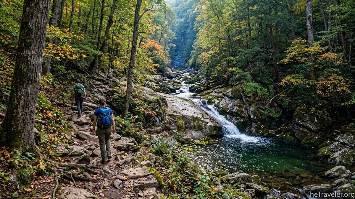
What the Lower Canyon Is Really Like
As Cedar Run drops away from Skyline Drive, the surrounding forest shifts from light and airy to more enclosed and dramatic. The trail hugs the mountainside, sometimes several dozen feet above the water, then drops closer to stream level as it negotiates rock steps and tight switchbacks. You will cross side seeps feeding the main creek, pass under leaning hemlocks and hardwoods, and occasionally scramble over deadfall from winter storms that have yet to be cleared.
Below the popular slide, the creek no longer feels like a gentle series of pools. It carves into a narrower channel, tumbling over ledges and around boulders that fill the space between the canyon walls. In early spring, snowmelt and rain can transform this stretch into a continuous rush of whitewater. By late summer, flows typically drop, revealing more of the sculpted bedrock and quiet pockets where trout hold in shadowed eddies. Many local hikers mention this lower section as their favorite part of Cedar Run precisely because it feels wilder and more intimate than the better‑known Whiteoak side.
One of the standout features is the lower waterfall, a taller drop that pours into a deep basin framed by mossy rock. Reaching the best viewpoint often requires carefully picking your way off the main tread along faint footpaths to rock outcrops near stream level. This is where experienced hikers slow down, eat a late lunch, and linger to listen to the echo of the falls in the narrow canyon. It is also where the difference becomes obvious between a quick taste of Cedar Run and a full exploration.
Farther down, as you close in on the link toward Whiteoak Canyon, the grade eases slightly and the canyon begins to open. The creek is still noisy, but the trail offers more frequent flat spots for breaks, and you are more likely to find yourself alone. On busy weekends, when the lower Whiteoak Canyon parking area can feel crowded by late morning, this section of Cedar Run often stays surprisingly quiet. For travelers who value a sense of immersion in the forest rather than checking off a specific viewpoint, that solitude is part of what makes pushing farther worthwhile.
Planning Your Day: Timing, Gear, and Safety
One practical reason many hikers turn around too early on Cedar Run is simple timing. It is common for travelers staying in Washington, DC or Richmond to leave mid‑morning, reach Skyline Drive around lunchtime, and start hiking in the early afternoon. With only a few hours of daylight left, they understandably prefer to stop at the first major attraction and avoid finishing by headlamp. If you want to see the best parts of Cedar Run, a different strategy pays off.
Aim to be at the Hawksbill Gap parking area shortly after park gates open or in the cool of early morning, especially in late spring and early fall when days start shorter and weekend crowds are heaviest. In good weather, a strong, prepared party can complete the Cedar Run and Whiteoak Canyon loop in about six to seven hours, including time for photos and breaks. That means starting no later than mid‑morning if you hope to finish comfortably before dinner. Carrying a simple headlamp in your pack is a wise precaution even if you plan a day hike, because fog, thunderstorms, or slower‑than‑expected progress can stretch your schedule.
Footwear matters more on Cedar Run than on some of Shenandoah’s other waterfall trails. The combination of steep grades, wet rock, and patches of loose gravel favors sturdy hiking boots or trail shoes with good tread rather than smooth‑soled sneakers or sandals. Trekking poles help on the long descent and punishingly steep climb back to the ridge, particularly if your knees are sensitive. Pack at least two liters of water per person on cool days and more in midsummer, when humidity can turn the climb out into a sweaty grind even beneath the forest canopy.
Safety is another argument for respecting Cedar Run’s full character. The rock slide and pools, while popular, are not supervised or engineered swimming facilities. Water temperatures can stay cold well into June, and water levels change quickly after storms. Before you or your traveling companions slide or jump, watch locals for a few minutes and assess the current flow. Never dive headfirst into an unfamiliar pool, and be prepared to skip water play entirely after heavy rain. Cell service in the canyon is patchy, and rescue teams in Shenandoah can take time to reach injured visitors on steep, rocky terrain.
Comparing Cedar Run to Nearby Whiteoak Canyon
Part of the reason Cedar Run is so often underestimated is that its neighbor, Whiteoak Canyon, gets most of the attention. Whiteoak’s six major waterfalls, spaced along a well‑trodden trail from the lower boundary parking area up toward Skyline Drive, appear in countless guidebooks and social media posts. Families who want a manageable out‑and‑back to a single big cascade often choose the lower Whiteoak route, while more ambitious hikers aim to see several falls in a day.
By contrast, Cedar Run is usually described as steeper, rockier, and more strenuous. Where Whiteoak offers obvious destinations at each named waterfall, Cedar Run feels more like a continuous canyon experience with several standout features embedded in a long descent. That difference suits some travelers and surprises others. If you are used to hikes where you check off a single viewpoint and turn around, Cedar Run’s best rewards will only appear once you embrace the idea of the journey itself as the attraction.
Seasonal use patterns play into this dynamic. On a typical October weekend, cars can spill out of the Whiteoak Canyon lower lot and along the local roads by late morning, with hikers of all ages clustered near the first big falls. Meanwhile, Cedar Run from Skyline Drive often sees far fewer people beyond the slide. Trail runners from regional clubs mention the Cedar Run and Whiteoak loop as a favorite training route precisely because it provides sustained elevation change and technical terrain without feeling overcrowded.
For visitors planning a long weekend in Shenandoah, a practical approach is to hike at least part of both drainages. One day might focus on the more accessible sections of Whiteoak Canyon from the boundary trailhead, especially if you are traveling with children or newer hikers. Another day, with an early start and a lighter group, can be devoted to tackling Cedar Run more fully from Skyline Drive, treating the lower canyon and potential loop as a marquee experience. Framing your visit this way reduces the risk of leaving the park feeling like you only saw the most photographed viewpoints.
Real‑World Itineraries That Go Far Enough
To translate all of this into concrete plans, consider how travelers actually structure Cedar Run days. A common weekend itinerary for a fit couple or small group staying at Skyland or Big Meadows might start with a 7 a.m. breakfast, a short drive to Hawksbill Gap, and a 8 a.m. trailhead departure. They would descend Cedar Run at a relaxed but steady pace, reaching the slide around 9 a.m., when it is still quiet, then continue to the lower falls by mid‑morning. After a long break, they might climb back the same way, returning to Skyline Drive in the early afternoon, for a total time of four to five hours on the trail.
A more ambitious party, perhaps a group of experienced hikers visiting from the Northeast, could plan the full Cedar Run and Whiteoak Canyon loop as a centerpiece of a three‑day Shenandoah trip. Starting at 8 a.m., they would descend Cedar Run past the slide and lower canyon, traverse the fire road, then visit some or all of the major falls on Whiteoak before climbing back to the ridge. With time built in for photography, lunch, and water refills, they might reach their car again around 3 or 4 p.m., tired but with a sense of having really explored the heart of this section of the park.
Even travelers on tighter timetables can adjust to see more of Cedar Run. For instance, a family from Richmond arriving at Shenandoah mid‑morning for a single day could choose to skip some of the more crowded Skyline overlooks and head straight to Hawksbill Gap, starting their hike earlier than they otherwise might. Rather than treating the slide as the endpoint, they could set a predetermined time goal, such as “we will hike for two hours downhill before turning around,” and stick to it. That approach, combined with realistic pacing and close attention to children’s energy levels, increases the chances of reaching beyond the typical turnaround zone.
What all of these examples share is intention. The hikers know in advance that Cedar Run’s best scenery does not appear in the first mile, and they plan accordingly. They bring enough water and food, they wear shoes suitable for steep, rocky trails, and they start early enough to travel at a safe, sustainable pace. Without that advance planning, it is easy to fall into the default pattern of stopping where everyone else stops, then wondering afterward what you might have missed around the next bend in the canyon.
The Takeaway
Cedar Run is not a casual stroll to a single postcard waterfall. It is a steep, demanding canyon hike whose finest moments arrive only after you have committed to going deeper, past the crowded rock slide and into the quieter lower gorge. The payoff comes in the form of intimate waterfall views, tucked‑away pools, and a sense of wildness that can be hard to find on more popular Shenandoah trails.
If you are planning a trip to Shenandoah National Park and are comfortable with challenging terrain, it is worth designing at least one full day around Cedar Run. Study current park maps, check recent trail conditions, and be honest about your group’s fitness and timing. Start early, carry proper gear, and treat the first few viewpoints as warm‑ups rather than final destinations.
Most importantly, resist the urge to follow the crowd’s turnaround point without thinking. On Cedar Run, the best parts often lie just beyond where most people stop. For travelers willing to give the canyon the time and respect it deserves, the hike can become one of the most memorable experiences of their visit to the Blue Ridge.
FAQ
Q1. How long is the Cedar Run hike if I want to see the best parts?
The out‑and‑back from Hawksbill Gap to the lower waterfall area is roughly 5 to 5.5 miles with a steep climb back. If you link Cedar Run with Whiteoak Canyon for a full loop, expect around 8 to 9 miles total.
Q2. Is Cedar Run suitable for beginners or young children?
Cedar Run is considered strenuous because of its steep grade and rocky tread, especially when wet. Confident older kids with hiking experience may enjoy sections of it, but families with small children often find the trail demanding and may be better served by easier waterfall hikes elsewhere in the park.
Q3. Where do I park to hike Cedar Run?
The most common starting point is the Hawksbill Gap parking area on Skyline Drive in the central district of Shenandoah National Park. From there, a signed trail drops toward Cedar Run. Some longer itineraries connect Cedar Run with Whiteoak Canyon from boundary parking near Weakley Hollow Road, but those are best for experienced hikers.
Q4. When is the best time of year to hike Cedar Run?
Spring and early summer usually offer the most impressive water flows, while October adds colorful foliage and cooler temperatures. Summer brings warmer water for swimming at the slide and pools but can be humid. Winter is beautiful but icy, and traction devices may be necessary.
Q5. Can I swim in the pools and use the natural rock slide?
Many visitors do swim and ride the slide in warm weather, but it is at your own risk. Water temperatures can be cold, depths change with conditions, and there are no lifeguards. Always check the current flow, avoid headfirst entries, and be prepared to skip swimming after heavy rain.
Q6. How crowded does Cedar Run get compared with Whiteoak Canyon?
The area near the rock slide can be busy on spring and summer weekends, especially midday. Beyond that point, Cedar Run is usually notably quieter than nearby Whiteoak Canyon, particularly in the lower canyon and along sections of the loop that connect to the fire road.
Q7. Do I need special gear for Cedar Run?
Sturdy hiking boots or trail shoes with good traction are strongly recommended. Trekking poles help with the steep descent and ascent. Pack plenty of water, a basic first‑aid kit, a map or offline navigation app, and a headlamp even if you plan to finish before dark.
Q8. Is Cedar Run safe to hike after rain?
Conditions vary, but the trail’s steep grades and rock features can become slick and hazardous when wet. Water levels in the creek and pools rise quickly after storms. If heavy rain is in the forecast, many hikers choose a less exposed route or postpone Cedar Run for a drier day.
Q9. Can I camp along Cedar Run or on the Cedar Run and Whiteoak Canyon loop?
Backcountry camping is allowed in parts of Shenandoah with a free permit and specific regulations, but campsites must be set away from trails and water sources. Because Cedar Run’s canyon is steep and narrow, good legal camping spots are limited. Day hikes are more common on this route.
Q10. How does Cedar Run compare to other challenging hikes in Shenandoah?
Cedar Run and its loop with Whiteoak Canyon offer elevation gain and rugged terrain on par with some of the park’s better‑known difficult routes, such as Old Rag. The difference is that Cedar Run focuses more on continuous canyon scenery and waterfalls than on summit views, making it a standout option for travelers who love moving water and quieter valleys.