
More news on this day
Storm systems tracking across the Midwest are expected to unleash torrential rainfall on the Chicago area Wednesday, raising the risk of flooding in saturated neighborhoods and signaling a disruptive day for air and ground travel.
Get the latest news straight to your inbox!
Heavy Rainfall Targets an Already Saturated Region
Forecast discussions and local weather outlooks indicate that multiple rounds of thunderstorms are poised to move across northeastern Illinois and northwest Indiana through Wednesday, with Chicago near the center of the most active zone. Meteorologists describe the storms as highly efficient rain producers, capable of dumping several inches of water in a short period of time.
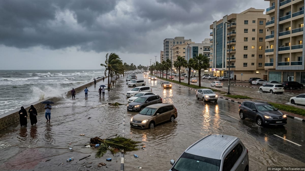
Recent coverage from regional outlets notes that parts of the metro area picked up one to three inches of rain over the weekend, leaving soil moisture elevated and low-lying locations more vulnerable to runoff. Hydrologic outlooks for northern and central Illinois point to localized totals surpassing 3 inches by the end of the event, particularly where storms repeatedly track over the same communities.
Publicly available forecasts highlight rain rates that may exceed 2 inches an hour within the most intense cells. Under those conditions, urban drainage systems can be quickly overwhelmed, leading to ponding on major roadways, flooded viaducts and renewed basement flooding in areas that have already struggled with water intrusions this month.
While exact rainfall amounts will vary from neighborhood to neighborhood, forecasters broadly expect a swath of 1 to 3 inches across much of the region, with higher pockets possible. For travelers and commuters, even totals on the lower end of that range can be enough to cause standing water and slower travel during the morning and evening peaks.
Flood Watches and River Concerns Across the Metro
Hydrologic outlooks and flood-related products from weather agencies covering the Chicago corridor outline growing concern for both urban and small-stream flooding on Wednesday. After several recent rain events, many creeks and rivers in Cook County and surrounding suburbs are already running high, leaving less capacity to absorb another soaking.
Recent reporting from local newspapers describes earlier flood warnings along smaller waterways in southern Cook County, including suburbs that saw basements inundated and streets temporarily impassable during the past week. With more rain on the way, communities along these same streams are again near the top of watch lists for potential renewed flooding.
Flood-prone viaducts and underpasses on the South and West Sides of Chicago, as well as low-lying sections of key commuter routes, are likely to be monitored closely as the heaviest rain develops. Past events have shown that a single intense band of storms can quickly turn these bottlenecks into hazardous choke points for traffic and public transit.
River forecasters will also be watching how quickly levels respond to the anticipated rainfall. Even if widespread, catastrophic flooding is not projected, a series of moderate rises could push some gauges near or above bankfull, impacting parks, trails and access roads along river corridors through late Wednesday and into Thursday.
Air Travel Disruptions Likely at O’Hare and Midway
The same storm system threatening heavy downpours is also expected to complicate operations at Chicago’s two major airports. National aviation advisories and recent experience this month suggest that slow-moving thunderstorms near arrival and departure corridors can trigger ground stops, holding patterns and widespread schedule disruptions.
In recent days, similar setups in the region have already produced delays of more than an hour for some flights to and from Chicago, as reported in local transportation and weather coverage. On Tuesday, a separate round of storms prompted a ground stop for flights bound for O’Hare, with departures also slowed while lightning and low visibility moved through the area.
On Wednesday, embedded strong storms with cloud-to-ground lightning, low ceilings and reduced visibility may again force controllers to space out arrivals and departures, cutting the number of planes that can safely move through the system at any one time. Travelers connecting through Chicago can expect ripple effects as delays at O’Hare and Midway cascade through airline networks.
Airport observers have noted that even when the worst storms are not directly overhead, weather nearby can lead to rerouted traffic and congestion in the skies over northern Illinois. With storms forecast in multiple waves, some airlines may proactively trim schedules or adjust departure times to keep operations manageable during the most active periods.
Severe Weather, High Winds and Travel Safety
Alongside flooding concerns, severe weather outlooks for Wednesday indicate that parts of the Chicago area could see damaging winds, hail and a nonzero tornado risk embedded within the broader thunderstorm complex. Regional television and online forecasts reference wind gusts that may reach or exceed 60 to 70 miles per hour in the strongest storms.
These wind levels are strong enough to down tree limbs, scatter unsecured outdoor items and potentially damage power lines, raising the possibility of localized outages. Combined with saturated ground, even modest gusts can more easily topple shallow-rooted trees, especially along parkways and boulevards where soils have not had time to dry.
Hail potential appears more limited and will depend heavily on how individual storm cells evolve, but forecasters have not ruled out pockets of larger hail south and west of the city center. For travelers on the road, severe storms could reduce visibility to near zero at times, making it difficult to see lane markings or standing water ahead.
Public service announcements circulating on local media urge residents to adjust their travel plans where possible, allow extra time and avoid driving through water-covered roadways. Aviation and transit watchers similarly emphasize the importance of checking flight status and rail alerts frequently, as conditions and schedules are likely to change rapidly through the day.
What Residents and Visitors Can Expect Through Wednesday Night
Forecast timelines compiled by regional broadcasters point to multiple windows for active weather, beginning with morning showers and storms that may intensify as they move across the city, followed by additional rounds during the afternoon and evening. The precise placement of the strongest cells will depend on evolving boundaries and temperature contrasts, but most of the metro area is expected to experience at least periods of heavy rain.
Visitors arriving for conferences, events or peak summer tourism should anticipate a day of unsettled skies, intermittent downpours and the possibility of lightning delays at outdoor attractions. Some lakefront areas may also contend with choppy conditions and elevated waves, which, in previous events, have prompted beach hazard statements and warnings about dangerous swimming conditions.
For local residents, the midweek storms come on top of a June pattern that has already featured several soaking rains. Neighborhoods that flooded earlier this month remain particularly sensitive, and municipal services are likely to focus efforts on known hot spots where drains clog quickly or where overland flow has caused repeated problems.
As the system gradually pulls away late Wednesday into early Thursday, rainfall intensity should ease, but standing water and residual travel disruptions could linger into the overnight hours. Rail schedules, highway traffic and flight operations may take time to fully recover, leaving some impacts in place even after the heaviest storms have moved east.