
More news on this day
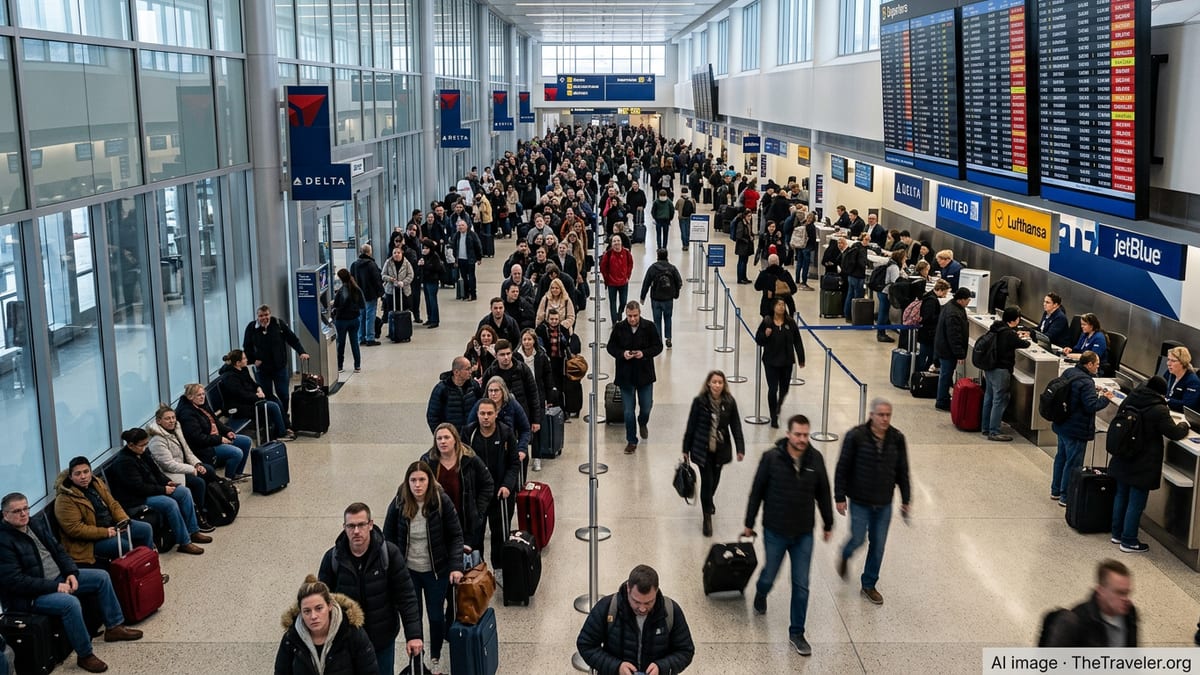
More than 200 flights were canceled and hundreds more delayed in Chicago on Wednesday as tornado watches and powerful thunderstorms swept across northern Illinois, disrupting operations at both O’Hare and Midway airports at the height of the summer travel rush.
Get the latest news straight to your inbox!
Severe weather threat collides with peak travel day
The latest round of storms arrived less than a week after multiple tornadoes were confirmed in the broader Chicago region, heightening concern as a new tornado watch was posted for much of Illinois on June 17. Publicly available outlooks from federal forecasters placed parts of the Chicago area under an elevated severe weather risk, with forecasters warning of the potential for strong, fast-moving storms capable of producing tornadoes, destructive winds, and large hail.
By late morning, flight-status boards at O’Hare International Airport showed a growing wave of cancellations and delays as thunderstorms formed along a volatile boundary draped across northern Illinois. According to aviation tracking data and airline status pages, the number of cancellations across the two major Chicago airports climbed into the low hundreds, with ripple effects spreading across airline networks nationwide.
Midway International Airport, a key base for domestic carriers and regional flights, also reported clusters of cancellations as storms intensified to the south and west of the city. Some departures were scrubbed preemptively as airlines attempted to reposition aircraft and crews before the most dangerous weather moved through the metropolitan area.
Air traffic management measures, including brief ground stops and reduced arrival rates, contributed to mounting delays even for flights that remained on the schedule. Passengers arriving at both airports encountered crowded gate areas, long rebooking lines, and frequent schedule changes as the storm line evolved.
Cancellations top 200 as airlines trim schedules
Operational data from flight-tracking services indicated that airlines collectively canceled more than 200 flights into and out of Chicago by early afternoon, with O’Hare bearing the brunt of the disruption. Regional connections to smaller Midwestern cities were particularly affected as carriers aimed to keep longer-haul routes intact while trimming more flexible short segments.
Some Chicago-bound flights diverted to nearby airports to wait out the worst of the storms, while other aircraft remained on the ground at origin cities as carriers held departures to avoid placing planes in the path of severe weather. Travelers reported on social media that certain early morning flights made it in or out before the storms peaked, only for later rotations on the same routes to be delayed for hours or canceled outright.
Summer thunderstorms frequently cause turbulence in airline schedules across the United States, but the added presence of a tornado watch typically prompts a more cautious posture. When forecasters highlight the potential for rotating storms, airlines and air traffic managers often slow operations further, leaving less capacity to absorb schedule shocks and resulting in a faster buildup of cancellations.
Industry analysts noted that while Chicago’s hub status makes it particularly vulnerable to weather disruptions, airlines are under added pressure in June due to strong leisure demand and relatively tight spare capacity. With many flights already operating close to full, rebooking displaced passengers can quickly become difficult once cancellations rise into the hundreds.
Travelers urged to prepare for extended delays
Publicly available guidance from major airlines and airport operators urged anyone traveling through Chicago to check their flight status frequently and build additional time into their plans. Many carriers activated weather waivers for affected airports, allowing passengers to change itineraries without standard fees, subject to fare rules and seat availability.
Passengers already at O’Hare and Midway described a patchwork of experiences, with some flights pushing back close to on time between waves of storms, while others remained stuck at the gate with crews and ground staff waiting for clearance from air traffic control. As storms repeatedly redeveloped over parts of northern Illinois, even flights that had boarded on schedule were sometimes forced back to the gate when new lightning or wind threats emerged.
Travel experts recommend that passengers in such conditions keep essentials like medications, chargers, and a change of clothes in carry-on bags, given the heightened risk of missed connections and unplanned overnight stays. Those with flexibility are often advised to accept earlier rebooking options offered via airline apps rather than waiting for in-person assistance once queues grow at service desks.
For travelers headed to time-sensitive events such as cruises, international tours, or major family gatherings, the combination of a tornado watch and widespread cancellations in a hub city like Chicago can present a particular challenge. Watching for alternate routings that bypass the most affected airports can sometimes provide a faster path to a destination than waiting for the next nonstop flight.
Stormy June compounds regional weather fatigue
The latest travel disruption comes amid what many residents describe as a punishing June for severe weather across Illinois. Published coverage from local outlets has documented a series of recent storms that produced numerous tornadoes, extensive tree damage, and prolonged power outages across parts of the Chicago region and neighboring states.
On Wednesday, forecasters again pointed to a moist, unstable air mass and strong upper-level winds as key ingredients for possible tornado development across portions of northern and central Illinois. A tornado watch in effect for a wide swath of the state, including the Chicago metropolitan area, underscored the risk that any thunderstorms that formed could quickly become severe.
Beyond the immediate storm threat, saturated ground and repeated rounds of heavy rain have also increased the potential for flash flooding in low-lying neighborhoods and along area rivers. Public communications from weather agencies and local governments highlighted the possibility of water-covered roadways, urging drivers to remain cautious during the afternoon and evening commute periods.
For visitors in town for business conferences, concerts, or summer festivals, the unsettled pattern has added a layer of uncertainty to plans. Event organizers and tourism businesses have closely monitored forecast updates, weighing schedule adjustments and contingency plans if tornadic storms or dangerous lightning approached outdoor venues.
What travelers passing through Chicago should know
As airlines work to recover from the wave of cancellations, travel planners suggest that people with upcoming flights into or out of Chicago in the next 24 to 48 hours monitor for knock-on impacts. Aircraft and crew displacements caused by Wednesday’s storms may still be affecting first-wave departures on Thursday, even if the immediate severe weather threat subsides.
Those driving to or from the airports during active tornado watches or severe thunderstorm warnings are often encouraged, through publicly available safety advisories, to allow extra time in case of sudden downpours, hail, or temporary road closures. Parking structures and passenger drop-off zones can become congested when storms push through at peak hours, further slowing the flow of arriving and departing travelers.
Travelers connecting through Chicago who have the option to change routings to alternative hubs may wish to consider those choices if their itineraries include tight layovers. Even modest new delays introduced by lingering weather impacts or traffic-management programs can be enough to disrupt close connections, particularly on international journeys with additional security and passport checks.
For now, the combination of an active tornado watch, strong June thunderstorms, and the central role of Chicago’s airports in the national aviation network has created another challenging day for air travel. As the severe weather threat gradually shifts east, airlines and passengers alike will be working to restore some measure of normalcy to one of the country’s busiest air corridors.