


Askja is one of Iceland’s most dramatic volcanic landscapes: a vast highland caldera tucked inside Vatnajökull National Park, with the deep Öskjuvatn lake and the smaller Víti explosion crater set among dark lava and lingering snowfields. Reaching it is an adventure in itself. The drive uses remote F-roads with river crossings, there are almost no services once you leave the Ring Road, and even in mid-summer the weather can feel wintry. This guide explains clearly what Askja is, what a visit realistically looks like in 1 to 2 days, and helps you decide whether to self-drive or join a guided tour.
Get the latest updates straight to your inbox!
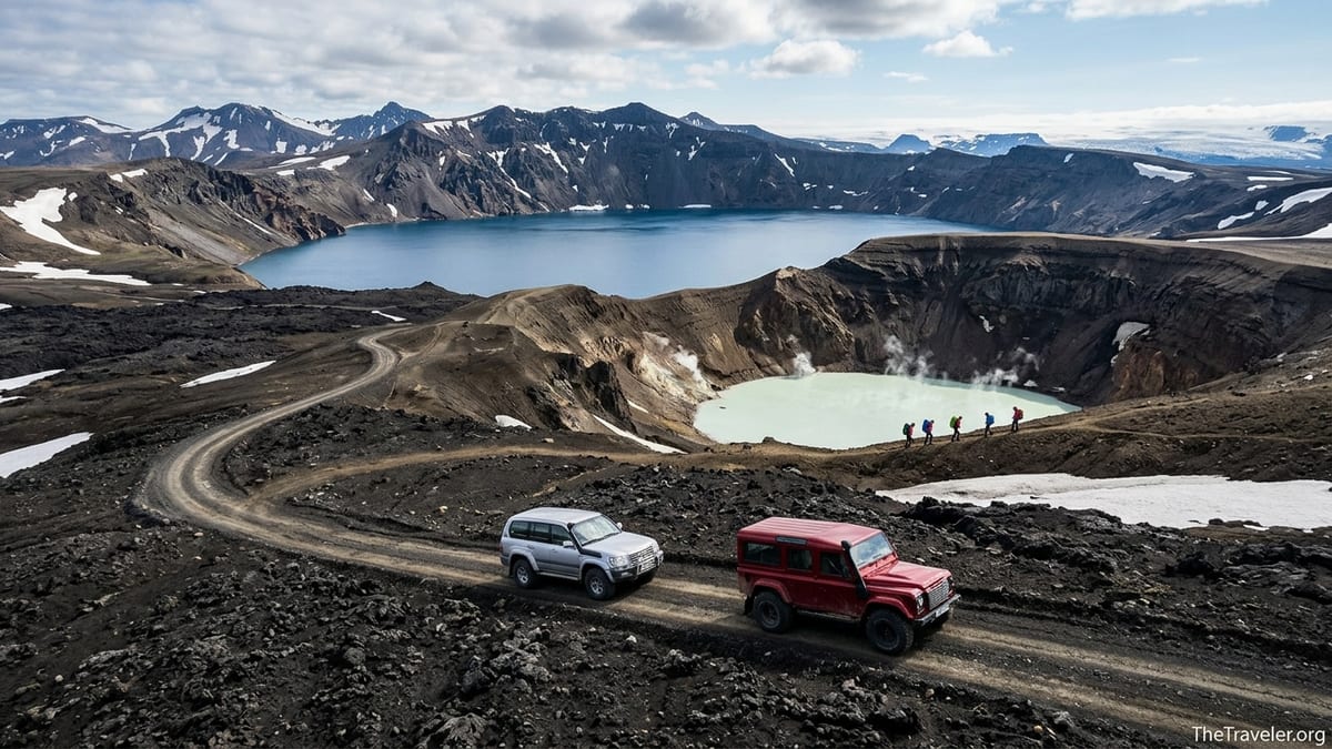
What and where is Askja, and why go
Askja is a central volcano and caldera complex in Iceland’s Northern Volcanic Zone, within the northern part of Vatnajökull National Park. The main depression is about 8 kilometers across, surrounded by the Dyngjufjöll mountains, with several nested craters formed by large eruptions. In the north of the caldera sits Öskjuvatn, one of Iceland’s deepest lakes, created when part of the floor collapsed in the late nineteenth century. Right beside it is the smaller Víti maar crater, partly filled with a milky geothermal lake.
Visitors are drawn to Askja for its sense of remoteness and its stark, almost lunar scenery. The black lava, ash slopes, rhyolite outcrops and lingering snow patches make it feel very different from the green lowlands around Lake Mývatn or the coastal towns of North Iceland. You are literally walking inside an active volcanic system, with views into the caldera and across to Vatnajökull’s distant ice cap on clear days.
Despite this appeal, Askja is not a casual stop. The caldera sits in Iceland’s interior highlands and is only accessible via unpaved F-roads that are open roughly from late June or early July until sometime in September, depending on snow and weather. These roads are legally 4x4 only, and some routes include unbridged river crossings. On top of that, the final approach includes a short but exposed highland hike from the Vikraborgir parking area to the Víti crater rim.
For self-planning travelers, especially those already circling the Ring Road and staying around Lake Mývatn or in North and East Iceland, Askja can be a highlight that justifies a full long day or an overnight detour. It suits people who enjoy remote landscapes, are prepared for long driving days, and accept basic facilities. Those unsure about their driving skills or equipment will usually have a better experience on a guided highland tour.
Is Askja right for you
Askja rewards travelers who value wild scenery and do not mind effort and uncertainty. Expect a total driving time of 7 to 10 hours on a self-drive day trip from the Mývatn area, depending on route, conditions and stops. Surfaces range from rough gravel to rocky tracks and sandy stretches, and river levels can rise after rain or warm weather. Once in the caldera you will hike for around 35 to 45 minutes each way from the Vikraborgir car park to the Víti and Öskjuvatn viewpoints, on an undulating volcanic path that can be snowy early in the season or muddy later on.
This sort of day suits experienced drivers who are comfortable with long days behind the wheel, use a proper high-clearance 4x4, and are used to judging road and weather conditions. It can also work for active older children or teens who enjoy hiking in cool, changeable weather. The area is stark and exposed, so younger children or anyone who strongly dislikes wind, cold or rough ground may find it more tiring than enjoyable.
Others are better off on an organized tour. Nervous drivers, people traveling in regular two-wheel-drive cars, and those unfamiliar with river crossings should not attempt to reach Askja independently via F-roads. Families with very young children may also find the long drive and basic facilities challenging. Guided 4x4 bus or super jeep tours handle all navigation and road decisions, and drivers are usually very familiar with local rivers and typical trouble spots.
The final factor is time. If your itinerary is already tight and you only have, for example, one night around Mývatn, squeezing Askja into the same window is rarely sensible. The trip is best when you can base in North or East Iceland for at least one night before and one night after, so that nobody is driving exhausted after an 11 to 13 hour outing.
Orientation: where Askja fits into an Iceland trip
Most independent visitors approach Askja from Lake Mývatn or North Iceland. The small village of Reykjahlíð on the lake’s northeastern shore is the usual base. From here to the caldera car park near Vikraborgir is roughly 130 to 150 kilometers each way, depending on your chosen F-roads, with only the first short stretch on the paved Ring Road. In good summer conditions this usually means around 3.5 to 4.5 hours of driving one way, but it can take longer if roads are rough or you stop often.
From Egilsstaðir in East Iceland, the distance to Askja is similar or slightly longer, again mostly on gravel or F-roads for the inland sections. Travelers coming from Akureyri typically drive first to the Mývatn area, which takes about 1.5 hours on the paved Ring Road, and then continue into the highlands the following day. All practical routes into Askja involve highland roads and are summer only; there is no easy paved shortcut.
Access is via F-roads that open and close according to snow and ground conditions rather than a fixed calendar. Data from recent summers shows that roads like F88, F905, F910 and the short spur to the Vikraborgir area tend to open sometime between late June and mid July, with closures often occurring from mid September onward. In some years roads may open earlier or later, or close temporarily after storms. Travelers planning an Askja detour must therefore check the Icelandic Road Administration’s current information shortly before their trip, and again on the day, rather than relying on averages.
Main approach options include the classic F88 route from the Ring Road north of Mývatn, which crosses several rivers, and the F905 plus F910 combination from the east side of Mývatn, which some drivers prefer in higher water conditions. All of these options are strictly 4x4 only, and any route choice should be guided by up-to-date road status, your vehicle’s ground clearance and your personal comfort level. Step-by-step driving details are better handled in a dedicated driving guide, but as a rule, if you are unsure about a crossing or feel pressured by time, the safest choice is to turn back.
What you actually do at Askja
For most visitors the experience follows a clear pattern. After leaving the Ring Road and driving into the highlands, your first main stop is usually the Dreki area, where there are simple huts, a ranger station in the main season, toilets and a basic campground. This is a natural place to break the drive, stretch your legs and get the latest local information on trail and weather conditions before continuing to the caldera.
From Dreki the track continues toward the Vikraborgir car park near the western side of the Askja caldera. This is where vehicles must be left. From the parking area, a marked walking route leads across undulating volcanic terrain toward Víti and Öskjuvatn. Vatnajökull National Park’s guidance describes this as an easy to moderate highland hike of about 2.4 to 2.5 kilometers each way, usually taking around 35 minutes one way for an average walker in summer conditions. Early in the season, however, snowfields can linger and slow progress.
On the hike you cross rough pumice and lava, sometimes with residual snow or slushy sections where meltwater pools. The landscape is open and there is little shelter. Rain, wind and cloud can roll in quickly, and temperatures at the caldera are often several degrees lower than on the coast or around Mývatn. Sturdy waterproof footwear, warm layers and windproof outer clothing are therefore essential even on seemingly bright days.
When you reach the crater area you can peer into the steep-sided Víti maar and look over the expanse of Öskjuvatn, which often retains floating ice well into summer. On clear days the combination of dark lava, snow patches and reflecting water is striking. Many visitors take time simply to walk along the rim, photograph the changing views and absorb the scale of the caldera walls before retracing their steps to Vikraborgir and driving back toward Dreki and the lowlands.
Víti crater, bathing and current cautions
Víti is one of Iceland’s best-known maar craters. It was formed in an explosive eruption, and its inner slopes are steep and friable in places. The small geothermal lake inside is often a cloudy blue-green color. You will find references in guidebooks and on older websites to bathing in Víti, and in some previous years visitors were allowed to descend to the water when conditions were stable. The descent route follows a narrow, muddy path down the crater wall, which can be extremely slippery when wet or icy.
Park authorities and rangers take a cautious approach to Víti access because conditions change and hazards are real. The combination of a steep slope, loose material, and geothermal activity means there is a risk of slips, rockfall and sudden changes in water temperature. Gases can occasionally accumulate in low spots in volcanic craters, particularly on calm days. As a result, the permission to go down to the waterline is reviewed regularly, and there is no blanket guarantee that it will be allowed at the time of your visit.
Current guidance from Vatnajökull National Park emphasizes that visitors must follow all on-site signs and ranger instructions regarding where you can walk and whether descent to Víti is open. Bathing, when allowed, is entirely at your own risk and is not encouraged as a primary reason to visit, partly because of the hazards and partly to reduce erosion of the fragile crater slopes. The water, although geothermally warmed in parts, is not a uniform hot-spring pool and can feel only modestly warm away from vents.
For planning purposes, it is sensible to treat the descent and bathing as a possible bonus rather than a core objective. You should already feel that the trip is worthwhile for the highland scenery and caldera views alone. Arrive equipped for cool, windy weather along the rim and focus first on enjoying the hike and the broader volcanic landscape.
Season, road openings and weather realities
Askja is a strictly seasonal destination for regular travelers. In practice, most years see the approach F-roads open sometime between late June and early July, once winter snow has melted and the ground has dried enough to avoid damage. Closure often comes in September, sometimes earlier for specific roads if early snow falls or repeated storms cause washouts. There is no fixed timetable that can be relied on from one year to the next.
The only reliable way to know whether you can reach Askja is to check the Icelandic Road Administration’s current F-road status shortly before your planned date and again on the day of travel. Many travelers also monitor the national weather forecast and safety advisories, as heavy rain or rapid thaw can render river crossings unsafe even when roads are technically marked open. Interior conditions may deteriorate quickly compared to the coast, so it is normal to adjust or cancel plans at short notice.
Early in the season, expect significant snow patches on the hiking route, frozen or partially frozen ground and chilly air temperatures. The upside is a very stark, wintry look, with snow contrasting against black lava. Later in July and August paths are usually clearer, and driving surfaces can be easier, although washboard sections and dust are common. In late August and September you may again encounter temporary snow and the risk of sudden closures, especially after the first proper autumn storms.
Because of this variability, it is wise to keep your Askja plans flexible within a broader North or East Iceland itinerary. Allow backup days in the same region so you can switch activities if the F-roads close or highland weather becomes unsuitable. Travelers who cannot spare this flexibility may find a guided highland tour a safer option, as reputable operators decide daily whether to operate and will cancel or reroute if conditions demand it.
Practical logistics, accommodation and tours
There is no hotel at Askja itself. Facilities in the highland core are intentionally simple, in keeping with the national park’s protection goals. The main on-site options are mountain huts and a basic campsite at Dreki, with toilets and limited shelter. In the peak summer season a ranger is usually based here to provide information and monitor conditions. Some visitors choose to spend one night at Dreki or camp nearby so that they can visit the caldera in the evening or early morning light and reduce the amount of driving in a single day.
Most travelers, however, base themselves around Lake Mývatn or in nearby parts of North Iceland and visit Askja as a very long day trip. Around Mývatn you will find a mixture of guesthouses, small hotels, farm stays and campsites with varying levels of comfort. Akureyri, the main town of North Iceland, offers more urban-style hotels and services and works well as a staging base if you then move closer to Mývatn before or after your Askja day to keep driving times manageable.
Guided day tours to Askja operate from several hubs in the main season. From the Mývatn and Reykjahlíð area, highland bus tours using 4x4 vehicles currently advertise full-day excursions of around 11 to 13 hours, including stops at Herðubreiðarlindir or other scenic highland spots. Recent price checks show typical adult rates in roughly the 40,000 to 60,000 Icelandic krónur range, depending on vehicle type, group size and inclusions. Some operators include a simple lunch or snacks, while others require you to bring your own food. Minimum participant numbers and operating dates vary and are always subject to road and weather conditions.
Akureyri-based operators may offer Askja day tours either directly or with a pickup transfer to meet a Mývatn departure. There are also occasional super jeep or private tours from Egilsstaðir or even longer day and multi-day packages that include Askja from Reykjavík, but these are more expensive and involve very long driving days. Anyone considering a tour should confirm in advance what is included, the approximate group size, and what happens if roads or weather prevent the vehicle from reaching the caldera on the day.
Safety, regulations and preparation
Iceland’s F-roads are legally designated mountain roads restricted to four-wheel-drive vehicles. Driving them in a standard passenger car is both illegal and unsafe. Rental contracts often contain specific clauses excluding damage from driving on unauthorized F-roads and almost always exclude damage from water crossings. If you drive through a river that your rental agreement does not cover and the engine or electrics are damaged, costs can be substantial and are typically borne by the renter.
Off-road driving, meaning leaving the marked tracks or established parking areas, is prohibited throughout Iceland, including within Vatnajökull National Park. The park’s regulations require visitors to stay on marked roads and paths, park only in designated areas and respect any temporary restrictions around sensitive sites like Víti and Öskjuvatn. Drone use is regulated and may be restricted or require permission in parts of the park, so travelers should always check the latest rules and, if in doubt, leave drones packed away in the highlands.
Practical preparation is vital. Before leaving the Ring Road, refuel fully, as there are no fuel stations at Askja or Dreki. Carry extra food and water for everyone in the vehicle, and pack proper warm clothing, including hats, gloves and a spare insulating layer, even in July and August. A fully charged phone and, ideally, a power bank are important, but remember that coverage can be patchy in the interior. Many local safety agencies recommend registering a travel plan and installing the national emergency app so that rescuers can more easily locate you if something goes wrong.
On the road, drive at a speed suitable for the surface, keep generous distances from other vehicles to avoid dust and stones, and never attempt a river crossing you feel unsure about. Watch out for soft verges and washouts. If warnings, closures or “impassable” notices appear on official channels, you must respect them. Turning back is inconvenient, but pushing on in unsuitable conditions risks your safety and can also damage fragile highland ecosystems.
Sample 1 and 2 day visit outlines
A realistic one-day self-drive trip from the Mývatn area typically starts early. After breakfast you would leave Reykjahlíð with a full tank and take your chosen F-road route into the highlands, aiming to reach Dreki by late morning. After a short rest and a check-in with the ranger, you continue to the Vikraborgir car park, walk to the Víti and Öskjuvatn viewpoints, spend time on the rim and then hike back to your vehicle. A late afternoon break at Dreki on the return can make the long drive back to Mývatn feel more manageable, with arrival in the evening.
Doing this as a guided tour follows a similar rhythm, but you leave the driving to professionals. Many tours from Mývatn depart around 7:30 or 8:00 in the morning and return 11 to 13 hours later, with commentary and planned stops en route. This suits travelers who want the Askja experience without the responsibility of navigating F-roads and river crossings. Those based in Akureyri may either drive themselves to Mývatn for an early pickup or join a tour that includes transfers.
A two-day version spreads the effort and adds flexibility. You might travel from Mývatn or Egilsstaðir to Dreki on day one, arriving in the afternoon, settling into a hut or camp and taking a short exploratory walk around the nearby canyon area in suitable conditions. On day two you visit the caldera early, when light and crowds are often at their best, then drive back to the Ring Road and continue on to your next coastal destination. This pattern reduces driver fatigue and gives you a better chance of adjusting your exact caldera visit window to fit weather and visibility.
Whether you opt for one long day or a slower overnight, and whether you self-drive or join a tour, the key is honest self-assessment. Askja is worth the effort for those who relish remote volcanic landscapes and are prepared for real highland conditions. With realistic expectations, proper preparation and respect for the regulations and environment, it can become one of the most powerful memories of a North or East Iceland journey.