
Alum Cave Bluffs is one of the most iconic day hikes in Great Smoky Mountains National Park, combining creekside walking, narrow rock staircases, and big mountain views in just a few miles. It is also one of the park’s most popular and demanding trails, which means first-time visitors are often surprised by steep grades, tricky footing, and crowded parking lots. If you are planning to hike to Alum Cave Bluffs on your next Smokies trip, a bit of advance knowledge can make the difference between a stressful slog and a memorable mountain day.
Get the latest updates straight to your inbox!
Trail Basics: Distance, Elevation and What to Expect
The standard hike to Alum Cave Bluffs follows the Alum Cave Trail from Newfound Gap Road to the bluffs and back. The round trip distance is roughly 4.5 to 5 miles depending on where you find parking and how far you walk along the road to reach the trailhead. Most hikers should plan on at least 3 to 4 hours for the outing, more if you like to stop often for photos or breaks.
From the trailhead to Alum Cave Bluffs you gain about 1,100 feet in elevation. The grade is gentle at first as you follow Alum Cave Creek, then becomes steadily steeper after Arch Rock and especially on the final climb to the bluffs. While many online descriptions call this “moderate,” visitors who are not used to hills often experience it as a fairly strenuous workout. Expect sustained uphill sections, rock steps, and some narrow drop offs.
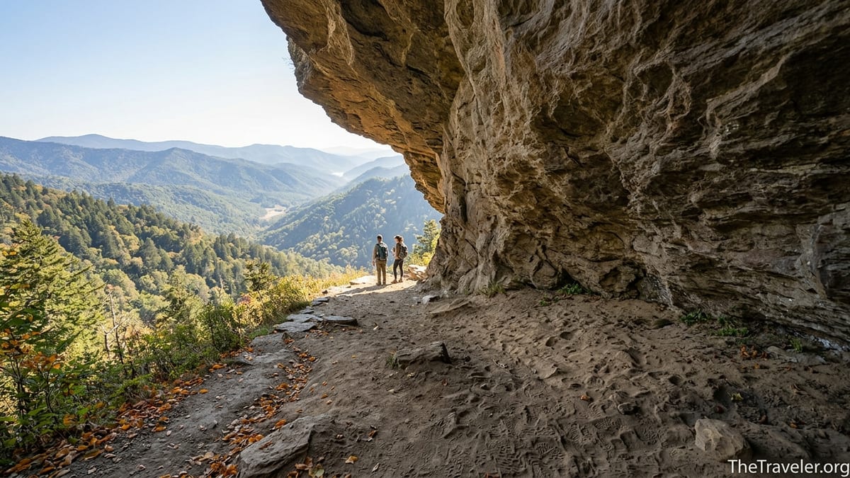
The bluffs themselves sit at just under 5,000 feet in elevation, a massive overhanging wall of exposed rock with views across the valley toward peaks like Mount Le Conte. The formation is not a true cave, but the overhang is large enough that you can comfortably stand underneath and feel protected from light rain. The ground beneath the bluff is dry and often dusty, and in summer the area can feel much cooler than the open trail below.
Beyond the bluffs, the Alum Cave Trail continues another 4 to 5 miles to Mount Le Conte and LeConte Lodge. Many social media posts come from hikers who have gone all the way to the summit, so do not assume every viewpoint or cabin you see online is on the shorter Bluff hike. If your goal is just Alum Cave Bluffs, you will turn around at the overhang and retrace your steps to the parking area.
Getting There, Parking and Permits
The Alum Cave Trailhead is located along Newfound Gap Road (US 441) between Gatlinburg, Tennessee and Newfound Gap. From downtown Gatlinburg it is roughly a 20 to 25 minute drive in normal traffic. If you are staying in Pigeon Forge or Sevierville, allow 45 minutes or more, especially in the busy months of June through October when traffic often slows to a crawl near the park entrances.
There are two paved parking areas for Alum Cave on the river side of Newfound Gap Road, along with short roadside pullouts that fill when the main lots are full. On most fair weather mornings between late spring and fall, the primary lots are often full by 8:30 or 9:00 a.m., and on holiday weekends they may overflow even earlier. Arriving before 8:00 a.m. significantly improves your chance of finding a spot close to the trailhead. If you arrive late and end up parking along the road, be prepared to add an extra quarter to half mile of walking each way.
Great Smoky Mountains National Park does not charge an entrance fee, but as of mid 2026 a parking tag is required if your vehicle will be parked for more than 15 minutes anywhere in the park. Tags are sold as daily, weekly, or annual stickers at visitor centers, many local outfitters, and pay kiosks at some larger parking areas. For a one day Alum Cave hike, most visitors purchase the inexpensive daily tag and place it clearly on the dashboard. Rangers do ticket vehicles without tags, so do not skip this step assuming you will be “back quickly.”
If you are coming from the North Carolina side of the park, factor in the drive over Newfound Gap Road, which can be slow and occasionally closed in winter conditions. Before setting out, check the park’s current alerts on the National Park Service website or call a visitor center. Temporary weekday trail closures for bridge or trail repairs have occurred in recent years near Alum Cave, and these are usually posted in advance but can surprise visitors who have not checked conditions.
Seasonal Conditions and When to Hike
Alum Cave Bluffs is hikable in most seasons, but your experience will vary significantly with the time of year. In late spring and early summer, typically May through June, you can expect lush green foliage, wildflowers along the creek, and moderate temperatures at higher elevations. However, this is also the start of the busy season, with crowded parking lots and a steady stream of people on the trail from mid-morning onward.
Mid summer into early fall, roughly July through early October, brings hot and humid afternoons at lower elevations and frequent afternoon thunderstorms. The climb from Arch Rock to the bluffs can feel demanding in the heat, and slick rock from sudden rain showers is a real hazard. Many local hikers choose to start at sunrise during these months, finishing the uphill push before the day’s heat builds and storms develop.
Autumn, from late September into early November, is one of the most popular times to hike Alum Cave Bluffs due to changing leaf colors across the Smokies. The ridgelines around Mount Le Conte glow with reds, oranges, and golds, and the views from Inspiration Point and the bluffs can be spectacular. The tradeoff is intense weekend crowding and full parking lots by early morning. If possible, plan a weekday hike or aim for a mid to late afternoon start if you are comfortable descending in partial darkness with a headlamp.
Winter and early spring hiking on Alum Cave can be stunning but risky. Ice often forms on the rock steps, at Arch Rock, and along the exposed sections with safety cables. At times, the bluffs themselves build up icicles hanging over the trail. On cold mornings you may find packed snow and ice on the climb even when Gatlinburg feels relatively mild. If you choose to hike in winter, carry traction devices such as microspikes, layer your clothing, and be prepared for rapidly changing conditions, including sudden fog and high winds near the bluffs.
What the Trail is Really Like: Landmarks and Terrain
The first stretch of the Alum Cave Trail follows a rushing mountain stream, crossing several sturdy log bridges. The grade here is gentle, making it easy to underestimate what is coming. Many families with children enjoy this lower section as a short out and back stroll and turn around before the steeper terrain begins. The sound of the creek and shaded forest make this a pleasant cool walk even on warmer days.
About 1.4 miles from the trailhead you reach Arch Rock, a natural rock arch formed by erosion. The trail climbs through the arch on a narrow stone staircase with a handrail. It feels dramatic, and this section can bottleneck when there are many hikers. People who are uneasy with heights often find this part more mentally challenging than physically demanding, but many manage it by taking the steps slowly and using the rail for balance.
Above Arch Rock the trail becomes steeper and rockier, with more frequent steps and short switchbacks. Around the 2 mile mark, a spur leads to Inspiration Point, a rocky outcrop with sweeping views across the valley. This is often the first point where you get a sense of the higher elevation landscape, and many hikers stop here for a snack break. On busy days, you may have to wait your turn for a spot at the edge for photographs.
From Inspiration Point, the final approach to Alum Cave Bluffs traverses some exposed slopes where the park has installed cables along the rock for safety. The path here narrows, and in wet or icy conditions you will want to keep at least one hand on the cable while stepping carefully. The trail then curves beneath the massive bluff. The open, sandy floor of the overhang is wide enough to accommodate dozens of people, and even when the area is busy you can usually find a place to sit, eat a snack, and enjoy the view.
Gear, Clothing and Food: What to Bring
Because the hike to Alum Cave Bluffs feels short on paper, some visitors underestimate what they should bring. A practical packing list looks more like a mountain day than a city stroll. At minimum, plan to carry 1 to 2 liters of water per person, depending on the season. In summer heat, adults who are not acclimated often finish the climb with empty bottles and wish they had packed more. A small water filter or treatment tablets can be helpful if you plan to refill from streams on the lower part of the trail, though many hikers simply carry all the water they need.
Footwear should have good traction and support. Lightweight hiking shoes or trail runners are common choices. People occasionally complete the hike in basic sneakers, but they are more likely to slip on wet rock and feel every stone underfoot. Sandals and flip flops appear every season and frequently lead to turned ankles or miserable descents. Trekking poles are useful for the steep sections above Arch Rock and can significantly reduce strain on knees during the downhill return.
Clothing should be layered. Even in June or September, it can be 10 to 15 degrees cooler at alum cave than in Gatlinburg, especially early in the morning. A light synthetic or wool base layer, breathable shirt, and a packable wind or rain jacket cover most conditions. Avoid heavy cotton sweatshirts that stay damp and clammy if you are caught in a shower. In winter, add an insulating layer and thin gloves or liner gloves, since you will want bare or lightly covered hands to grip the safety cables on icy sections.
Bring enough food for a half day outing. Simple trail fare like nuts, granola bars, jerky, and sandwiches travel well. Many hikers pack a late breakfast to enjoy at the bluffs. There are no trash cans on the trail, so plan to pack out all wrappers and food scraps. Small critters like squirrels are accustomed to human presence at Alum Cave, and feeding them, intentionally or not, creates problems for both animals and future visitors. A small zip bag for trash and a lightweight first aid kit with bandages, blister treatment, and pain relievers round out a sensible day pack.
Staying Safe: Weather, Crowds and Common Mistakes
Alum Cave Bluffs is not a technical climb, but the combination of exposure, changing mountain weather, and heavy use demands respect. One of the biggest safety issues is people underestimating the time and effort required. Starting the hike at 3:00 p.m. in October without a headlamp, for example, sets you up for a twilight descent on rocky steps and narrow ledges. Aim to be leaving the bluffs at least two hours before sunset, and carry a small headlamp in your pack even if you expect to be back earlier.
Weather can change quickly along Newfound Gap Road and near Mount Le Conte. On some summer days, clear blue skies in Gatlinburg give way to thunder and heavy rain by mid afternoon at higher elevations. Lightning is a serious threat on exposed ridges and high viewpoints. If you see dark clouds building or hear distant thunder while you are at Alum Cave, consider cutting your visit short and heading down. In winter, icy conditions are the main concern. Falls on frozen steps or near the cables can have serious consequences, and there have been accidents in recent seasons on and near this trail.
Crowds introduce their own hazards. On busy days the lower bridges and Arch Rock can become congested, and impatient hikers sometimes try to pass in unsafe spots. Take your time, wait your turn at narrow sections, and offer to let uphill hikers pass first when practical. If you are hiking with children, keep them close when the trail narrows or when you approach the cable sections and the edges near Inspiration Point and the bluffs.
Another common mistake is poor footwear or minimal gear in shoulder seasons. It is not unusual in March or early April to see visitors in street shoes and cotton hoodies struggling on slushy or icy slopes, while better prepared hikers move more comfortably with microspikes and trekking poles. Finally, remember there is no cell service in many parts of the trail corridor. Do not rely on live maps or quick calls for help. Tell someone your plan and expected return time before you leave town.
Extending Your Day: Going Beyond Alum Cave Bluffs
For strong hikers with more time and good weather, the Alum Cave Trail can be the first portion of a much longer day to Mount Le Conte. From the bluffs, it is roughly another 2.7 to 3 miles one way to LeConte Lodge and the high point of Mount Le Conte, with an additional 1,600 feet or so of climbing. The full round trip to the summit and back via Alum Cave is close to 11 miles, with more than 2,700 feet of total elevation gain. This is a big mountain day, so it should only be attempted if you are already comfortable with similar distances and elevation profiles.
Along the way to the summit, the trail passes through spruce fir forest and opens to views at spots like Cliff Tops and Myrtle Point, both accessible via short side paths from the main route. Many experienced hikers plan an early start from the Alum Cave trailhead, reach LeConte Lodge by late morning or midday, eat lunch on the mountain, then descend by mid to late afternoon. Because the upper mountain often holds snow and ice into late spring, traction devices may be necessary well after lower elevations look dry.
Some visitors combine Alum Cave with other area attractions to create a full Smokies day. A common itinerary is a predawn or early morning hike to the bluffs, followed by a scenic drive up to Newfound Gap or Clingmans Dome, then dinner in Gatlinburg or Pigeon Forge. Others pair a shorter lower trail walk along Alum Cave Creek with time at Sugarlands Visitor Center exhibits or a stop at one of the roadside picnic areas along Little River Road.
If you are planning an overnight at LeConte Lodge, your route to and from the lodge may include Alum Cave on one leg and a different trail like Trillium Gap or Rainbow Falls on the other. Reservations at the lodge typically book far in advance, so most first time Alum Cave hikers experience the trail as a day trip rather than as part of a lodge stay.
The Takeaway
Hiking to Alum Cave Bluffs offers a concentrated taste of what makes the Smokies special: clear mountain streams, dramatic rock features, cool high elevation air, and sweeping views. It is also a hike where preparation matters. The combination of a relatively short mileage description and spectacular online photos draws many people who are not used to mountain terrain, and they can be surprised by the steepness, crowds, and quickly shifting weather.
If you treat Alum Cave Bluffs as a real mountain outing rather than a casual stroll, you will likely have a safer and more enjoyable experience. Start early, secure your parking tag, bring enough water and snacks, wear sturdy footwear, and layer for cooler conditions higher on the mountain. Pay attention at narrow sections, respect storms and ice, and give yourself plenty of time to return before dark.
Whether you turn around at the bluffs or continue toward Mount Le Conte, the day will stick with you. The sound of water along Alum Cave Creek, the cool shade of Arch Rock, and the wide view from beneath the bluff are the kinds of moments that often become the highlight of a Smokies trip. With realistic expectations and a bit of planning, “checking off” Alum Cave will feel less like a box on a list and more like a genuine mountain adventure.
FAQ
Q1. How long does it take to hike to Alum Cave Bluffs and back?
Most visitors spend about 3 to 4 hours completing the roughly 4.5 to 5 mile round trip, including short breaks and time at the bluffs. Strong hikers who move efficiently may do it a bit faster, while families with children or frequent photo stops may take closer to 5 hours.
Q2. Is the Alum Cave Bluffs hike suitable for beginners?
It can be a challenging outing for true beginners because of the sustained uphill grade and uneven rocky terrain, especially above Arch Rock. Fit first time hikers who go slowly, start early, and bring enough water and snacks usually manage it fine. Those who are not used to hills might consider turning around at Arch Rock or Inspiration Point on their first visit.
Q3. Do I need a permit or parking reservation to hike Alum Cave?
You do not need a trail permit or timed entry, but you do need a valid Great Smoky Mountains parking tag if your vehicle will be parked for more than 15 minutes. The tag is purchased separately from any lodging reservations in Gatlinburg or nearby towns and should be displayed clearly in your vehicle while you are on the trail.
Q4. What is the best time of day to start the hike?
Starting in the early morning, ideally between sunrise and 8:00 a.m., gives you cooler temperatures, a better chance at parking near the trailhead, and more daylight margin if you decide to linger at the bluffs. In hot summer weather, an early start also helps you avoid climbing the steepest sections during the warmest part of the day.
Q5. Can children hike to Alum Cave Bluffs?
Many families successfully hike to the bluffs with school age children who have some trail experience. Parents should be prepared for a steady uphill climb and keep a close eye on kids in narrow or exposed sections, especially near Arch Rock, the cable protected traverses, and the edge of the bluff area. Bringing snacks, frequent rest breaks, and a flexible turnaround point helps younger hikers enjoy the day.
Q6. Is the trail very exposed to heights?
There are a few sections between Inspiration Point and the bluffs where the trail narrows and the slope drops away on one side. The park has installed cables along the rock in these spots and most people who are mildly uncomfortable with heights manage them by going slowly and using the handhold. Those with severe fear of heights might choose to turn around before reaching these sections.
Q7. What should I wear and bring for a typical summer hike?
In summer, wear breathable hiking clothes, sturdy shoes with good traction, and a hat or sunglasses. Pack at least 1 to 2 liters of water per person, some salty snacks or lunch, a light rain jacket for afternoon storms, sunscreen, and a small first aid kit. Trekking poles are optional but helpful on the steep descent. Even in warm months, a light extra layer can be welcome in the shade at the bluffs.
Q8. Can I hike Alum Cave Bluffs in winter?
Yes, but you need to be prepared for potentially icy and snowy conditions. The steps at Arch Rock, the rocky sections near the cables, and the area around the bluffs can become slick. Microspikes or similar traction, warm layered clothing, gloves, and a hat are highly recommended. Always check for any road or trail advisories before driving up Newfound Gap Road in winter.
Q9. Are dogs allowed on the Alum Cave Trail?
No, dogs are not allowed on most Great Smoky Mountains National Park hiking trails, including Alum Cave. Pets are restricted to developed campgrounds, picnic areas, and along roads, including some short nature trails and the Gatlinburg Trail. If you are traveling with a dog, plan to leave them in appropriate care while you hike.
Q10. Is there cell service on the trail?
Cell coverage is spotty to nonexistent along much of the Alum Cave Trail. You may have a weak signal near parts of Newfound Gap Road but should not count on using your phone for maps, weather updates, or emergency calls once you are on the trail. Download maps in advance, tell someone your plans, and be prepared to be offline while you hike.