
In a national park packed with classic hikes, the Alum Cave Trail manages to feel like three or four great Smokies adventures woven into one. In just a few miles it takes you from mossy creek crossings and old-growth forest to narrow rock staircases, open ridgelines, and the famous Alum Cave Bluffs high on the flank of Mount Le Conte. For travelers choosing how to spend a precious day in Great Smoky Mountains National Park, understanding what sets this trail apart helps you decide if it deserves a spot at the top of your list.
Get the latest updates straight to your inbox!
A Big-Mountain Experience in a Shorter Package
Many Great Smoky Mountains hikes make you choose between a gentle forest walk and a serious all-day climb. Alum Cave is unusual because it offers a true big-mountain feel in a relatively compact outing. From the trailhead on Newfound Gap Road, you gain roughly 1,100 feet of elevation in the 2.3-mile climb to Alum Cave Bluffs, and about 2,700 to 3,000 feet in total if you continue the full way to Mount Le Conte’s summit area. That elevation profile is comparable to popular summit routes out West, but here it is compressed into 5 miles one way, which fits into a long half-day for fit hikers.
By contrast, gentler Smokies favorites such as Laurel Falls or Grotto Falls might only climb a few hundred feet and rarely break out of the forest canopy. They are excellent family walks, but they do not give you the sense of topping out above valleys or looking across layers of blue ridgelines. On Alum Cave, by the time you reach Inspiration Point, you are staring out over Little Duck Hawk Ridge and Myrtle Point, feeling the park spread beneath you. Travelers staying in Gatlinburg often comment that a morning on Alum Cave gives them the same sense of scale they expect from much longer routes like the Appalachian Trail sections at Newfound Gap, but without committing an entire day.
For visitors with just a weekend in the Smokies, that matters in practical ways. You can leave a cabin in Pigeon Forge or Gatlinburg after breakfast, reach the trailhead in about 25 to 30 minutes, hike to the bluffs and back in four to five hours with photo stops, and still have time for an evening dinner reservation in town. If you are more ambitious and push on to LeConte Lodge and back, you are looking at a demanding 10-mile day, but you can still drive back to your hotel before dark in summer.
Distinctive Landmarks You Will Not See on Other Trails
Alum Cave’s character comes from a string of natural landmarks that you encounter in quick succession. Within the first mile, you follow Alum Cave Creek and walk on narrow log bridges low to the water. Soon you reach Arch Rock, a tall, naturally sculpted arch in a solid wall of black slate-like rock. Here, the trail climbs through the middle of the formation on a set of built stone steps with a handrail. It is one of the few places in the Smokies where you feel momentarily funneled through a rock feature in this way, more reminiscent of Utah’s slot approaches than a typical Appalachian forest path.
Beyond Arch Rock, the forest opens slightly and you start hitting small overlooks. Around 1.9 miles, at Inspiration Point, a side area of exposed rock lets you look down into the steep valley known as Arch Rock Basin and out toward peaks such as Little Duck Hawk Ridge. On clear days, you can see the layers of ridges dissolving into the Tennessee haze, something most lower-elevation waterfall trails cannot match. Hikers often pause here for a mid-morning snack and to take photos before the final climb to Alum Cave Bluffs.
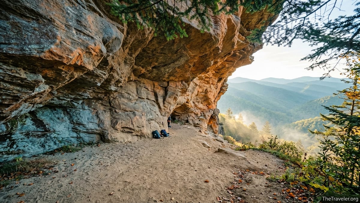
The bluffs themselves are the signature feature. Despite the name, Alum Cave is not a true enclosed cave but a massive concave sandstone overhang about 75 to 80 feet high and several hundred feet long. On rainy days you can stand under the orange and gray rock and stay mostly dry while watching clouds move across the valley. In winter, long icicles hang from the lip; in summer, the sand underfoot is often dry and powdery even after storms, a result of the overhang acting as a natural umbrella. Trails like Chimney Tops or Rainbow Falls have dramatic endpoints, but few give you this combination of shelter, elevation, and sweeping views in one spot.
Past the bluffs, if you continue, the trail becomes narrower and more rugged, crossing exposed ledges with cable handlines in a few places. This upper section traverses the flank of Mount Le Conte, eventually reaching the lodge and side paths to viewpoints such as Cliff Tops and Myrtle Point. For hikers who only know the Smokies from river-level walks like Abrams Falls, this high-country traverse feels surprisingly alpine, with fir and spruce forest and cooler temperatures that can be 10 to 15 degrees lower than in Gatlinburg.
Rich Human History Carved Into the Route
Another way Alum Cave stands apart from many Smokies hikes is the amount of human history bound up in the trail corridor. In the 1800s, the bluffs area was an active mining site for alum, saltpeter, and epsom salts. These minerals were used in everything from tanning leather to producing gunpowder. The route that modern hikers follow evolved from older tracks used by miners and pack animals climbing up from the valleys. While the forest has largely swallowed the industrial traces, interpretive signs and guidebooks sold in Gatlinburg and at visitor centers still highlight this chapter, giving context that trails like the quieter Ramsey Cascades lack.
Local stories also cling to the modern hiking era. One mid-trail landmark, a rocky outcrop nicknamed Gracie’s Pulpit, is said to honor a beloved Smokies hiker who used Alum Cave to reach Mount Le Conte into her nineties. Whether or not every detail of the tale is exact, the point for travelers is that this path has been central to the park’s hiking culture for decades. When you meet fellow hikers at the bluffs swapping stories about past trips to LeConte Lodge or describing how they first came here as children, you are stepping into a shared tradition that goes beyond simply ticking off another scenic overlook.
Compared with waterfall-oriented routes like Indian Creek and Juney Whank Falls, which mainly highlight natural features, Alum Cave gives you a layered sense of how people have moved through and made use of this mountain landscape. Even the stonework and staircases that stabilize the steepest sections are the result of a dedicated Trails Forever restoration project completed over multiple seasons. Knowing that crews carried rock and tools up the same narrow path you are on can deepen your appreciation of each switchback.
Trail Engineering and Variety Rarely Matched in the Park
From an on-the-ground perspective, what sets Alum Cave apart is how often the terrain and tread change. The first mile meanders along creeks on soft forest duff, easy underfoot and shaded by hemlock and rhododendron. After Arch Rock, the tread shifts to rockier, stair-stepped segments. Near the bluffs, you cross open, sandy sections where past mineral extraction and erosion have left the ground light in color and coarser in texture. If you go all the way to Le Conte, the path narrows on cliff edges where the park has installed steel cables as handrails.
For hikers accustomed to the straightforward gravel of Laurel Falls or the rooty but predictable climb to Rainbow Falls, these transitions feel surprisingly dynamic. You might use trekking poles in the rocky middle section, stow them to navigate the rock staircase inside Arch Rock, then take them out again above Alum Cave to steady yourself on icy patches in shoulder seasons. This variety keeps experienced hikers engaged, while the presence of built steps and railings means that fit, cautious novices can still tackle the route in good conditions.
The trail’s popularity has also driven improvements. Great Smoky Mountains National Park, working with partner organizations, has invested in drainage features and rock retaining walls here precisely because Alum Cave draws so much traffic. Unlike some lesser-known paths that can be muddy troughs after a storm, the main sections of Alum Cave usually shed water well, so your boots are less likely to sink into deep muck. That said, early spring snowmelt and summer thunderstorms can still leave slick spots, especially on the shaded rock around Arch Rock and on the bluff’s approach, making sturdy footwear more important here than on paved or heavily graveled routes.
For travelers comparing hikes, this means Alum Cave delivers a “constructed mountain trail” experience closer to what you might find on classic national park routes in the Rockies, while still retaining the lush, enclosing feel that defines the Smokies. You are rarely more than a few minutes from a built staircase, stone causeway, or cable, yet much of the time you feel enveloped by deep forest.
Access, Parking Pressure, and Practical Logistics
Another factor that makes Alum Cave different is how its popularity shapes the logistics of your day. The trailhead sits alongside Newfound Gap Road, about 6.8 miles from Sugarlands Visitor Center and roughly 12 miles from downtown Gatlinburg. The parking area is relatively small for such a popular route, with fewer than 70 official spaces. On busy spring and autumn weekends it often fills shortly after sunrise, something you experience less intensely at more dispersed trailheads like those for the Lower Mt. Cammerer route or the Deep Creek waterfall loop near Bryson City.
Because Great Smoky Mountains National Park now requires a parking tag for vehicles staying more than 15 minutes anywhere in the park, you need to factor that into your planning. Day tags are modestly priced and sold at visitor centers and kiosks, but they do not guarantee a space at Alum Cave specifically. As a result, many hikers staying in Gatlinburg or Pigeon Forge aim to arrive at the lot by 7:00 a.m. in peak season. Others use authorized shuttle services based in gateway towns to be dropped off at the trailhead, avoiding the parking hassle altogether. These local operators typically charge per person or per group, and while exact prices change year to year, they are often competitive with what you might pay for a day’s downtown parking and gas.
Compared with quieter routes like the Maddron Bald or Big Creek trails, where you might roll up at 10:00 a.m. and still find parking, Alum Cave demands more structure. That has practical advantages, though: knowing you have a shuttle pick-up time or a self-imposed schedule encourages you to keep an eye on pace, weather, and daylight. Travelers with limited mobility in their group often appreciate that the lower creekside section of the trail allows for an easy out-and-back even if they give up the steeper upper miles. Meanwhile, stronger hikers can push farther without everyone committing to the full climb.
Cell service is spotty or nonexistent at the trailhead and along most of the route, a common Smokies reality but one that matters especially on a crowded, in-demand trail where you cannot rely on rideshare apps for a pickup. It is wise to screenshot maps from a popular hiking app or download the area offline before leaving Gatlinburg. In practice, navigation is straightforward, with clear signage and a single main path, but having your route saved and knowing the mileage to landmarks like Arch Rock (around 1.3 miles) and Alum Cave Bluffs (roughly 2.3 miles) helps you make on-the-fly decisions.
Seasonal Drama: How Alum Cave Changes Through the Year
While every Smokies trail shifts with the seasons, Alum Cave’s variety makes those changes especially dramatic. In April and May, the lower forest erupts with spring wildflowers, and water levels in Alum Cave Creek can be higher, making the early footbridges livelier and the air cooler and damper. By June, the mountain laurel and rhododendron near Inspiration Point begin to bloom, adding splashes of pink and white around the overlooks.
Summer brings heat and humidity to Gatlinburg and Pigeon Forge, but the higher elevation along the trail makes it noticeably cooler, sometimes enough that hikers slip on light fleece at Alum Cave while people are in T-shirts down in town. Afternoon thunderstorms are common; the bluffs can offer some shelter, though park guidance generally advises against lingering under rock overhangs in active lightning storms. Practically, this means starting early to be headed downhill before the biggest cells build, a schedule that pairs well with an afternoon visit to an air-conditioned museum or restaurant after your hike.
Autumn is often considered peak season on Alum Cave. The mix of hardwoods and evergreens along the route means you get classic Smokies color in October, with red and gold leaves framing views of blue ridgelines from Inspiration Point and beyond. This is also when parking competition is fiercest, and hiking midweek can make a big difference. Compared with lower, heavily forested routes like the Oconaluftee River Trail, Alum Cave delivers more panoramic foliage scenes, which is why it frequently appears on “best fall hikes” lists compiled by regional travel publications.
Winter is where Alum Cave diverges most sharply from many other popular Smokies trails. Ice can form on the stairs in Arch Rock and on the bluff approach, and huge icicles develop on the overhang itself. The park occasionally warns visitors to watch for falling ice. On clear winter days, however, the low sun angles and crisp air can make the mountain views exceptionally sharp. While families might opt for safer, lower-elevation loops when snow is in the forecast, experienced hikers with traction devices on their boots often cite Alum Cave as one of their favorite cold-season routes precisely because of the icy spectacle.
How Alum Cave Compares to Other Classic Smokies Hikes
When travelers stand at the Sugarlands Visitor Center information desk asking which hike to choose, rangers often mention several classics: Alum Cave, Chimney Tops, Rainbow Falls, and Laurel Falls. Each offers a distinct flavor of the Smokies. Chimney Tops is steep and rocky, with a shorter distance but intense grades; Rainbow Falls focuses on its namesake waterfall; Laurel Falls is relatively easy and paved for much of its length, making it accessible for strollers and casual walkers. Alum Cave, by contrast, does not have a single waterfall or summit as its only goal. Instead, it strings together multiple “mini destinations” that feel like checkpoints in a longer mountain journey.
For example, a family with mixed energy levels might decide that Grandma and the younger kids will hike just to the arch, enjoy the cool shade and creek crossings, then return to the car. The more enthusiastic adults could continue to Inspiration Point and perhaps to the bluffs before turning around. This tiered structure, with clear intermediate highlights, is not as prominent on routes like Ramsey Cascades where the main attraction is strictly at the far end of the trail. On Alum Cave, you never feel like you have to reach only one specific endpoint to make the outing worthwhile.
Compared with Trillium Gap or Brushy Mountain, which also lead toward Mount Le Conte but wander through quieter backcountry, Alum Cave feels more social. On a Saturday in September, you might pass dozens of other hikers, hear a range of accents from around the United States and abroad, and trade trail conditions with people coming down from LeConte Lodge. For some travelers, that shared energy is part of the appeal; they want a hike that feels like a communal event rather than a solitary expedition. Others who crave solitude may prefer starting Alum Cave at dawn on a weekday or choosing less-trafficked trails for their main backcountry experience.
Ultimately, what makes Alum Cave different is not one single statistic or feature but the combination: creekside walking, rock tunnels, huge overhangs, and big views, all within reach of a half-day schedule and a short drive from a major tourist town. In a park with hundreds of miles of trails, that blend is relatively rare.
The Takeaway
Alum Cave Trail is often recommended as a “must-do” Smokies hike for good reason. It compresses a diverse slice of Great Smoky Mountains scenery and history into a route that most reasonably fit travelers can tackle in a single morning or afternoon. From the engineered rock staircase inside Arch Rock to the sweeping views under the towering Alum Cave Bluffs, it delivers more shifts in terrain and perspective than many longer regional hikes.
At the same time, it demands a bit more planning than a casual stroll to a roadside waterfall. Parking fills early, weather shifts quickly with elevation, and the rock features that make the trail exciting also call for sturdy shoes and attention underfoot. If you are willing to set an alarm, pick up a parking tag or arrange a shuttle, and carry layers along with water and snacks, Alum Cave can offer one of the most memorable outings of your Smokies trip.
For travelers deciding how to spend limited days in Great Smoky Mountains National Park, the trail’s uniqueness lies in that balance. It feels adventurous without being extreme, iconic without being inaccessible. In a park known for its misty forests and hidden hollows, Alum Cave hands you the full high-country drama, then returns you to town in time for supper.
FAQ
Q1. How long is the Alum Cave Trail, and how difficult is it?
The hike to Alum Cave Bluffs is about 4.6 to 5 miles round trip and is usually rated moderately strenuous because of steady elevation gain and some rocky, uneven sections. If you continue to Mount Le Conte, the total distance is roughly 10 to 11 miles round trip with a much more demanding climb.
Q2. Do I need a parking tag or permit to hike Alum Cave?
Yes, Great Smoky Mountains National Park requires a parking tag for vehicles that will be parked more than 15 minutes, including at the Alum Cave trailhead. You do not need a separate hiking permit for a standard day hike, but overnight trips to backcountry campsites near Mount Le Conte require reservations through the park’s backcountry system.
Q3. When is the best time of year to hike Alum Cave Trail?
Late spring through fall is the most popular time, with wildflowers in April and May and colorful foliage in October. Winter can be beautiful with snow and ice, but conditions are more hazardous and may require traction devices and extra warm layers.
Q4. How early should I arrive to find parking at the trailhead?
On busy spring, summer, and fall weekends, it is wise to arrive by around 7:00 a.m. to improve your chances of getting a space in the main lot. On quieter weekdays or in winter, you may find spots later in the morning, but parking can still fill quickly during peak holidays and leaf season.
Q5. Are there shuttle services to Alum Cave Trail?
Yes, several authorized shuttle companies based in Smokies gateway communities offer drop-offs and pickups at Alum Cave trailhead, especially from March through October. Travelers often use these services to avoid the stress of finding a parking space or to link hikes that start and end at different trailheads.
Q6. Is Alum Cave suitable for children or beginner hikers?
Many families hike at least the lower portion to Arch Rock or Inspiration Point with school-age children who are comfortable walking several miles. However, the trail has steep, rocky sections and drop-offs near the upper reaches, so close supervision and realistic expectations are important. Very young children or those unused to hiking may do better on shorter, gentler trails.
Q7. Can I bring my dog on Alum Cave Trail?
No, dogs are not allowed on most trails in Great Smoky Mountains National Park, including Alum Cave. Pets are generally limited to campgrounds, picnic areas, roads, and a few designated short walking paths.
Q8. What gear should I bring for a day hike to Alum Cave Bluffs?
At minimum, pack sturdy hiking shoes or boots with good traction, one to two liters of water per person depending on temperature, snacks or a light lunch, a small first-aid kit, and an extra layer such as a light fleece or rain jacket. Trekking poles are optional but can be helpful on the steeper, rockier sections and during the descent.
Q9. How does Alum Cave compare with other well-known Smokies hikes?
Compared with Laurel Falls or Grotto Falls, Alum Cave is longer, steeper, and more rugged, but it offers bigger mountain views and a wider variety of terrain. It is less steep but longer than Chimney Tops, and more structured with multiple intermediate landmarks than waterfall-focused hikes like Rainbow Falls.
Q10. Is it safe to hike Alum Cave in bad weather?
Conditions can change quickly, and the trail includes exposed rock, narrow ledges, and an overhang where ice and rockfall are possible. In heavy rain, thunderstorms, ice, or snow, the risks increase. Checking the weather forecast, starting early, turning around if conditions deteriorate, and avoiding lingering under the bluff during active storms all improve safety.