


Guayama sits on Puerto Rico’s south coast close to mangroves, beaches and mountain forests, but getting around takes more planning than in compact, walkable Old San Juan. Attractions are spread across the historic center, the coastal barrios of Pozuelo and Aguirre, the Jobos Bay wetlands, and the hills leading into Carite State Forest. This guide explains how to reach Guayama from San Juan, Ponce and other common bases, what to expect from local roads and parking, and how to combine rental cars, taxis and limited public transport into a workable plan.
Get the latest updates straight to your inbox!
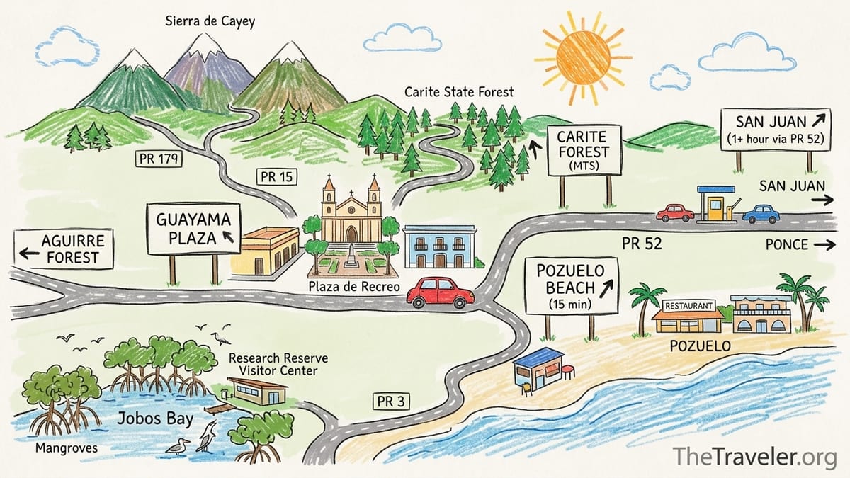
Understanding Guayama’s Layout and Distances
On a map Guayama looks like a single municipality, but for visitors it behaves more like a small hub with outlying pockets of interest. Historic Guayama centers on the plaza around Iglesia San Antonio de Padua and Casa Cautiño, where you can comfortably explore on foot once you park. From there, the coastline and mountain areas radiate out in different directions, each requiring a separate drive.
The coastal barrio of Pozuelo, known for simple seaside restaurants and access to Jobos Bay, sits roughly a 15 to 20 minute drive southeast of the town square in normal traffic, largely along PR 3 and local spur roads. Aguirre and the edges of the Aguirre State Forest are another coastal target, reached via PR 7710 from the PR 3 corridor. To the north, the road network climbs quickly into the foothills of the Sierra de Cayey toward Carite State Forest, connecting Guayama to Cayey via PR 179 and to scenic sections of the Ruta Panorámica on roads such as PR 15 and PR 7741.
These distances are short in miles but significant in time once you factor in two lane rural roads, occasional construction and strong weekend traffic. There is no single walking route that sensibly links the plaza, Pozuelo, the mangroves at Jobos Bay and the mountain forest in Carite. Treat each cluster as its own mini destination and plan how you will get to and from your parking point rather than expecting to walk between them.
The practical result is that Guayama rewards travelers who think like drivers, not urban flâneurs. You will likely park near the plaza for a half day in the center, then drive to Pozuelo or Aguirre for a meal or coastal walk, and on a separate outing tackle the inland roads toward Carite. Understanding that rhythm in advance keeps expectations realistic and avoids long, uncomfortable roadside walks in heat and humidity.
Driving to Guayama from San Juan
For most visitors staying in the San Juan area, the fastest route to Guayama is by rental car along Autopista Luis A. Ferré, designated PR 52. This toll highway runs south from the San Juan metro through Caguas and Cayey before turning southwest toward Ponce, with signed exits for Guayama and nearby municipalities. Under light traffic, various routing tools and transport planners estimate a drive time of about 1 hour 10 minutes to 1 hour 20 minutes from central San Juan to Guayama, with a distance around 70 to 75 kilometers. One popular multimodal planner lists the drive at 71 kilometers and roughly 1 hour 11 minutes in typical conditions, which lines up with local estimates.
However, that time is not guaranteed. PR 52 experiences heavy commuter congestion southbound in the early morning leaving San Juan and northbound in the late afternoon and early evening returning toward the capital. Dynamic toll or express lanes operate between San Juan and Caguas specifically to manage peak hour traffic, reflecting how variable conditions can be. South of Caguas, the road climbs into the mountains, often with fog, rain and reduced visibility, especially in the Cayey area. Ongoing stabilization and reconstruction work has been reported at points along PR 52 in recent months, with the Department of Transportation and Public Works highlighting lane shifts and reduced speeds near Cayey and between Ponce and Juana Díaz. Drivers should expect construction zones and occasional delays rather than assuming full speed highway conditions end to end.
When approaching Guayama from San Juan via PR 52, most travelers either exit toward Salinas then connect east along PR 3, or continue to a signed interchange that funnels traffic toward Guayama’s urban area and coastal zones. For example, official instructions to the Jobos Bay National Estuarine Research Reserve visitor center direct southbound drivers to leave PR 52 at exit 60 for Guayama, then follow PR 706 and PR 3 westbound. That same combination of toll highway plus PR 3 and local roads works well for entering Guayama’s coastal sectors from the north and northeast.
In practical terms, if you pick up a compact rental car at San Juan’s Luis Muñoz Marín International Airport in the morning and drive straight via PR 52, you can usually reach the plaza area near Casa Cautiño in around 1 hour and 15 minutes in normal traffic. Discover Puerto Rico’s visitor information materials generalize Casa Cautiño as being about one hour from San Juan by car, which is reasonable as a ballpark figure, but you should always build in a buffer for traffic, toll booth queues, mountain weather and potential construction slowdowns. Treat 90 minutes door to door as a safer planning number for day trips.
Reaching Guayama from Ponce and the South Coast
From Ponce and the wider south coast, Guayama is one of the easier destinations to reach by car thanks to the same PR 52 corridor. Driving distance tables maintained by Puerto Rico tourism resources commonly list Ponce to Guayama at roughly 61 kilometers with an estimated drive time of about 45 to 50 minutes without significant traffic. That estimate assumes you join PR 52 eastbound from Ponce and exit near Guayama or Salinas depending on your exact target.
If you are already exploring the south coast between Santa Isabel and Salinas on PR 1 or PR 3, you can continue east along PR 3 toward Guayama without returning to the toll highway. PR 3 serves as the primary coastal road in the southeastern part of Puerto Rico once PR 53 runs out, linking municipalities like Salinas, Guayama and beyond. This is a slower, signalized road that passes through built up areas with traffic lights, local businesses and side road entries. Many drivers appreciate the more scenic feel and easier access to seaside barrios like Pozuelo, but you should plan extra time compared with staying on PR 52.
For travelers coming from east coast bases such as Palmas del Mar near Humacao or the Yabucoa and Maunabo area, Guayama is usually approached along PR 3 westbound. While the raw distance might look short, stretches of PR 3 and related mountain tunnels further east can slow to local speeds and are sensitive to weather. The key planning point is that Guayama sits on a junction of PR 3, PR 52 and mountain roads like PR 179. Once you are on any of these main routes, road signage consistently points toward Guayama, but GPS and navigation apps remain highly recommended due to complex interchanges and local detours.
If you are building a broader south coast road trip, Ponce, Guánica, La Parguera and Cabo Rojo all connect efficiently via PR 2 and PR 52. Many visitors will, for example, leave Ponce in the late morning, stop in Santa Isabel or Salinas for lunch along PR 1 or PR 3, then continue to check in at a guesthouse near Guayama by mid afternoon. That pattern keeps individual driving segments under an hour and allows some flexibility to slow down when traffic or construction intensifies along the corridor.
Highways, Mountain Roads and PR 7710
Guayama’s access roads are a mix of modern toll highways and older, narrower mountain and rural routes. PR 52 between San Juan, Cayey, Salinas and Ponce is built to near interstate standards with divided lanes, guardrails and toll plazas, though steep grades and sharp curves appear in the mountain segments. PR 3, the coastal road, is mostly two lanes each way or one lane in each direction with frequent intersections and driveways. It acts as the main artery for southeastern Puerto Rico when the parallel PR 53 is not present, so you share the road with local delivery trucks, school buses and farm vehicles.
Once you leave PR 52 or PR 3 for nature areas, the road character changes quickly. PR 7710, which provides access to Aguirre State Forest trailheads and birdwatching zones, is an example. Tourism and forestry resources describe parking and trailheads near kilometer marker 2.6 along PR 7710, and maps show this route branching off the PR 3 corridor south of Guayama. It is a regular paved local road but narrower than the highways, with limited shoulders and occasional potholes or encroaching vegetation. Lighting is sparse at night, so daytime visits are strongly preferred, especially for first time drivers.
Heading inland toward Carite State Forest involves other mountain roads such as PR 179 and segments of the Ruta Panorámica like PR 15 and PR 7741. Planning documents for the panoramic route note that PR 7741 between Cayey and Guayama offers impressive views of the southern coast and forest, but that tall roadside vegetation can sometimes invade the roadway, partially blocking sightlines. Independent hiking and off road guides describe certain tracks within or near Carite as moderately technical, with dirt surfaces that can become muddy or rutted in the rainy months between roughly May and November. They emphasize that actual conditions change quickly with weather and that official environment and natural resources authorities should be consulted for updated access information.
Given these variables, drivers should think in terms of conservative speed, low gears on descents and a readiness to turn back if visibility, fog or washouts make a segment feel unsafe. Navigation apps may try to route you on very narrow or little used connectors between PR 179, PR 7741 and other mountain roads to save a few minutes. It is often wiser to stick to better known pavement, even if it looks slightly longer on the map, especially in the late afternoon when mountain clouds and rain tend to build.
Parking and Walkability in Historic Guayama
Within Guayama’s historic core, the experience shifts from driving strategy to parking strategy. The central square around Plaza de Recreo Cristóbal Colón, Iglesia San Antonio de Padua and Casa Cautiño is compact and walkable once you arrive. Streets in the heritage zone are generally narrow one way or two way lanes with curbside parking, interspersed with small municipal lots and private pay lots attached to businesses. Signage may be in Spanish only, but “Estacionamiento” marks formal parking areas.
In practice, visitors arriving from San Juan or Ponce will commonly follow GPS directions that bring them to streets like Calle Baldorioty or Calle Calimano near the plaza, then circle once or twice to find an available curbside space. On weekdays, you may encounter informal parking monitors or attendants in safety vests near busier corners who help direct vehicles into open spots. On market days, festivals or evenings when there are events at the plaza, spaces closest to the square fill up; in those cases, plan to park a few blocks away and walk five to ten minutes.
Legally enforced paid street parking zones, where they exist, are more common in San Juan than in smaller towns like Guayama, but the municipality can implement local rules and posted time limits. Because specific enforcement policies can change and are not always documented comprehensively online, the safest approach is to read each curbside sign before you leave the car and to avoid partially blocking driveways or marked loading zones. In absence of clear signage, it is sensible to assume that overnight parking in tight historic streets may inconvenience residents even when technically legal, so many visitors with a hotel or guesthouse nearby opt to park in a dedicated lot overnight.
Once your car is parked near the plaza, the main sights in the center, including Casa Cautiño and the church, are comfortably explored on foot within one to two hours. Side streets offer cafes, bakeries and small shops in easy walking distance. What you should not expect is to leave the vehicle in the plaza area and walk to Pozuelo, Aguirre, the Jobos Bay wetlands or any mountain viewpoint. The distances are too long, the tropical sun too intense and the roads too narrow for safe or pleasant roadside walking.
Local Transport, Taxis and Rideshares
Rental cars are the dominant way leisure travelers move between Guayama’s dispersed attractions, but there are some local transport options to be aware of. Within the municipality, a free collective service branded as “Guayama en Ruta” has been promoted in recent months. Local news coverage describes it as a municipal transport initiative using buses or vans on fixed circuits to connect neighborhoods and key points in the urban area at no cost to riders. It is intended primarily as everyday mobility for residents rather than a tourist hop on hop off system, but an English or Spanish speaking visitor who can confirm routes and stops with municipal staff may find it helpful for short in town hops, for example between a lodging in a residential barrio and the central plaza.
Beyond that, formal regional bus services linking Guayama to San Juan or Ponce are limited. Some long distance buses operate from San Juan to major southern cities, and colectivo style shared vans occasionally serve the broader south coast, but schedules are irregular and often not published in a way that short term visitors can easily verify. Online journey planners that cover Puerto Rico will sometimes list “shuttle” or transfer options from San Juan to Guayama with approximate fares and times, but these usually refer to pre arranged private transfers or chartered vehicles rather than walk up public buses in the European sense.
Taxi services exist in Guayama, but they are not as plentiful or easy to hail as in San Juan’s tourist corridors. Many operate by phone dispatch and prioritize local medical trips, airport transfers and school runs. You might find a taxi waiting near the plaza during weekday business hours, but hoping to rely on taxis spontaneously for evening beach returns or mountain pick ups is risky. It is far better to have the number of a recommended local driver from your hotel or restaurant and arrange your return time in advance.
Rideshare availability is similarly uneven. Uber has an established presence in the greater San Juan area and is increasingly common in Ponce and some resort zones. In smaller municipalities like Guayama, however, coverage can fluctuate by time of day. Travelers sometimes report getting a ride into the area with Uber or a similar app but then being unable to secure a car for the trip back, particularly at night or early in the morning. For that reason, using a rideshare for a one way trip from San Juan to Guayama with the assumption that you will easily order another car home on demand is not advisable. At a minimum, you should have a backup plan, whether that is a pre booked transfer, a rental car, or the flexibility to stay overnight rather than attempt a late night return.
Rental Cars: Advantages and Realistic Expectations
Given Guayama’s spread out attractions and the patchy nature of public transport, most visitors will find that renting a car unlocks the most flexibility. Major international agencies along with local companies operate counters at Luis Muñoz Marín International Airport in San Juan, at Mercedita International Airport in Ponce, and in several resort areas. A compact or mid size sedan is usually sufficient for reaching Guayama, Pozuelo, Aguirre and the signed viewpoints along the main sections of PR 179 and PR 15 in dry conditions. A full size SUV or four wheel drive is only necessary if you plan to tackle rougher forest tracks or remote trailheads in consultation with local authorities.
Rental rates change with demand and season, particularly around winter holidays and summer weekends. As an indicative example, in the current season it is common to see daily base rates for a compact car from major brands in San Juan ranging from the equivalent of around 35 to 60 US dollars per day before taxes, fees, toll tags and insurance. Some agencies bundle electronic toll passes that automatically bill you for autovía tolls such as those on PR 52. Others charge separate activation or per day toll program fees. Because specific costs vary between companies and are subject to change, travelers should verify current pricing directly with the rental provider they choose rather than relying on any single quoted number.
Driving norms around Guayama mirror the rest of Puerto Rico. Locals are used to the curves and grades of PR 52 and the mountain roads, and may travel faster than a visiting driver is comfortable with. It is perfectly acceptable to keep to the right, use turnouts where available to let faster cars pass, and maintain a speed that feels safe for you, especially in wet conditions. Seatbelt use is compulsory, and headlights are recommended in rain and low visibility. If you are unfamiliar with toll roads, ask the rental agent to explain whether your car’s plate is linked to a toll account, what roads are tolled, and how the charges will appear on your bill.
One important reality is that a rental car is not a magic shield against delays. Construction around PR 52, sudden tropical downpours and accidents can all slow traffic significantly at short notice. This is particularly relevant if you are using Guayama as a base for activities but must catch a flight in San Juan or Ponce. Always allow more time than your navigation app suggests, especially during weekday rush hours and on Sunday afternoons, when traffic returning toward San Juan from the south and central mountains often backs up.
Sample Transport Strategies for Common Trips
To make these considerations more concrete, it helps to look at sample strategies for three popular itineraries: a day trip from San Juan, a south coast road trip, and a two night stay based in Guayama. These are not rigid templates, but they illustrate how to align driving segments, parking choices and local transport realities with a realistic schedule.
For a San Juan to Guayama day trip focused on the historic center and the coast, a workable plan might start with picking up a rental car near the airport or in Isla Verde around 8:00 in the morning. You would drive PR 52 south, allowing at least 90 minutes to account for traffic and possible construction near Caguas or Cayey, and aim to park near the Guayama plaza by 10:00. After two to three hours exploring Casa Cautiño, the church and nearby streets on foot, you would return to the car for a short drive, perhaps 20 minutes, toward Pozuelo or another coastal spot for a late lunch. You could then visit a signed viewpoint or boardwalk section near Jobos Bay, before leaving around 16:00 to 16:30 for the return to San Juan. With another 90 minute driving window in the late afternoon, you would arrive back in the capital around early evening without having to rush.
On a multi day south coast road trip connecting San Juan, Ponce and the west, Guayama can be woven into a more leisurely loop. One example is to leave San Juan via PR 52, stop in Guavate near Cayey for a pork lunch, and then descend to Guayama in the afternoon, using the town as a brief base to explore Aguirre State Forest or Pozuelo. The next morning, you might continue west along PR 3 and then PR 1 or PR 52 toward Ponce, reaching the city in under an hour of driving. After one or two nights in Ponce, you could continue along PR 2 to beaches around Guánica or Cabo Rojo. In this pattern, individual drives stay short, and Guayama serves as a south coast flavor stop with specific nature outings, rather than an isolated day trip from San Juan.
For a two night Guayama stay, you gain enough time to tackle both the coast and the mountains without stacking long drives in a single day. On arrival day, drive in from San Juan or Ponce and focus on the historic core, leaving the car parked in or near your lodging once you are checked in. Day two might start early with a drive along PR 7710 to the Aguirre State Forest parking near kilometer 2.6, allowing several hours for birdwatching walks and quiet time in the mangroves, then an afternoon and sunset in Pozuelo. On day three, if conditions and official advice allow, you could head inland in the morning via PR 179 toward Carite State Forest, exploring accessible viewpoints or short trails before returning to Guayama and then onward to your next base. Throughout, you rely on your own car rather than trying to piece together intermittent taxis or rideshares, but you keep each segment modest so you are back in town well before dark.
The Takeaway
Guayama rewards travelers who pair curiosity about its mangroves, coast and mountain forests with honest planning about transport. The municipality is not a single walkable neighborhood but a cluster of distinct areas connected by toll highways, coastal roads and narrow mountain routes. Historic Guayama can be comfortably explored on foot once you park near the plaza, yet Pozuelo, Aguirre, the Jobos Bay wetlands and Carite State Forest all require separate drives and clear decisions about when and how you will return.
Driving from San Juan or Ponce is straightforward in principle but subject to traffic, weather and construction on key corridors like PR 52 and PR 3. Official information and local reporting both underline that travel times, including the often quoted “about one hour” from San Juan to Casa Cautiño, are approximations, not guarantees. Rental cars offer the most flexible way to manage these variables, with taxis, rideshares and municipal services such as “Guayama en Ruta” playing supporting roles rather than forming a complete standalone system for visitors.
If you treat Guayama as a place for shaped excursions, with the car as your connector and each cluster of sights as its own mini destination, you can build day trips and multi day stays that feel relaxed instead of rushed. Understanding the road network, respecting the limits of rural public transport, and leaving margin for the unexpected will help you enjoy the best of Guayama’s history, coast and highland forests.
FAQ
Q1. How long does it really take to drive from San Juan to Guayama?
Under light traffic, many drivers make the trip in about 1 hour 10 to 1 hour 20 minutes via PR 52, but construction, mountain weather and rush hour can extend that to 90 minutes or more, so it is wise to plan for extra time.
Q2. Is Guayama’s historic center walkable once I park?
Yes. The blocks around the main plaza, Casa Cautiño and the church are compact and easily explored on foot, with cafes and shops in short walking distance, but coastal and mountain attractions are too far to walk from the plaza.
Q3. Can I visit Pozuelo, Jobos Bay and Carite without a rental car?
It is possible but inconvenient. You would need to rely on a mix of pre arranged taxis, occasional rideshares and perhaps help from local guides or friends. For most visitors, a rental car is a more reliable solution.
Q4. Are there tolls on the main route to Guayama?
Yes. The usual route from San Juan uses PR 52, which is a toll highway. Many rental cars come with electronic toll billing, but you should confirm how charges are handled with your rental company.
Q5. What is driving on PR 7710 like?
PR 7710 is a paved local road used to access parts of Aguirre State Forest. It is narrower than the main highways, with limited shoulders, and can have potholes or vegetation near the edges, so slower, cautious driving in daylight is recommended.
Q6. Is there public transport within Guayama for visitors?
The municipality operates a free local service called “Guayama en Ruta” that helps residents move around town. It can be useful for short hops, but routes and schedules are not designed primarily for tourists and should be confirmed locally.
Q7. Will I be able to get an Uber or similar rideshare in Guayama?
Coverage is inconsistent. You may find rides during the day, but availability drops at night and in rural areas. You should not rely on rideshares as your only way back from beaches or mountain areas.
Q8. Is the drive to Carite State Forest from Guayama difficult?
The roads climb into the mountains with curves, changing weather and some narrow sections. In dry daylight, careful drivers in regular cars can manage the main paved routes, but conditions can worsen quickly in rain, and some side tracks require higher clearance or local guidance.
Q9. Where is the best place to park in Guayama’s center?
Most visitors look for curbside spaces or small lots within a few blocks of the main plaza. There is no single large garage, so you may need to circle once or twice and then walk five to ten minutes to reach the square.
Q10. Is Guayama a good base for a south coast road trip?
Yes. Its position near PR 52 and PR 3 makes it a convenient stop between San Juan and Ponce. With a car, you can combine the historic center, Aguirre’s mangroves, Pozuelo’s coast and nearby mountain viewpoints as part of a wider loop along Puerto Rico’s south coast.