
At first glance, Great Smoky Mountains National Park feels welcoming. Families push strollers toward Laurel Falls, retirees amble the paved path to Kuwohi’s observation tower, and casual hikers pose beside log bridges on the Deep Creek waterfalls loop. Then someone points toward the serrated ridge rising above Gatlinburg and says, "Let’s do Mount Le Conte." That is often where an easy-going Smokies vacation suddenly turns into a true mountain test.
Get the latest updates straight to your inbox!
From Friendly Valley Walks To A Serious Mountain
The Smokies are famous for being approachable. With more than 800 miles of trails and a huge variety of short, gentle walks, it is easy to understand why so many visitors think of this park as a place for casual hiking rather than serious climbs. Laurel Falls, a roughly 2.6 mile out and back hike on a mostly paved path, attracts first-time visitors who want an 80 foot waterfall without much effort. The Sugarlands Valley Nature Trail and Cataract Falls, both near the main visitor center, let families with small children experience the forest in less than an hour on mostly flat ground.
Even some of the “view” hikes feel friendly. The short but steep paved path up to the observation tower on Kuwohi, still widely known as Clingmans Dome, is less than a mile one way. Many people tackle it in sneakers, stopping at benches whenever the grade bites. Down in Cades Cove, the Abrams Falls trail winds about 5 miles round trip along a river, with only moderate climbs. For most visitors, these outings confirm the idea that Smoky Mountains hikes are short, scenic and fundamentally manageable.
Then there is Mount Le Conte. Rising to 6,593 feet, it is not the highest peak in the East, but the combination of sustained elevation gain, weather exposure and distance from the trailhead is a shock for hikers who have only sampled the park’s easy offerings. The most popular route, the Alum Cave Trail, is often described by guidebooks as “moderate to strenuous.” On paper that sounds reasonable. In real life it can feel like a different world from the paved path to Laurel Falls.
This contrast is part of what defines the Smokies. It is entirely possible to spend three days doing short, gentle walks and then, on day four, find yourself clinging to a cable rail on an icy, wind scoured ridge on the way to Le Conte’s summit. Understanding that leap in difficulty is the key to deciding whether Mount Le Conte belongs on your Smokies itinerary.
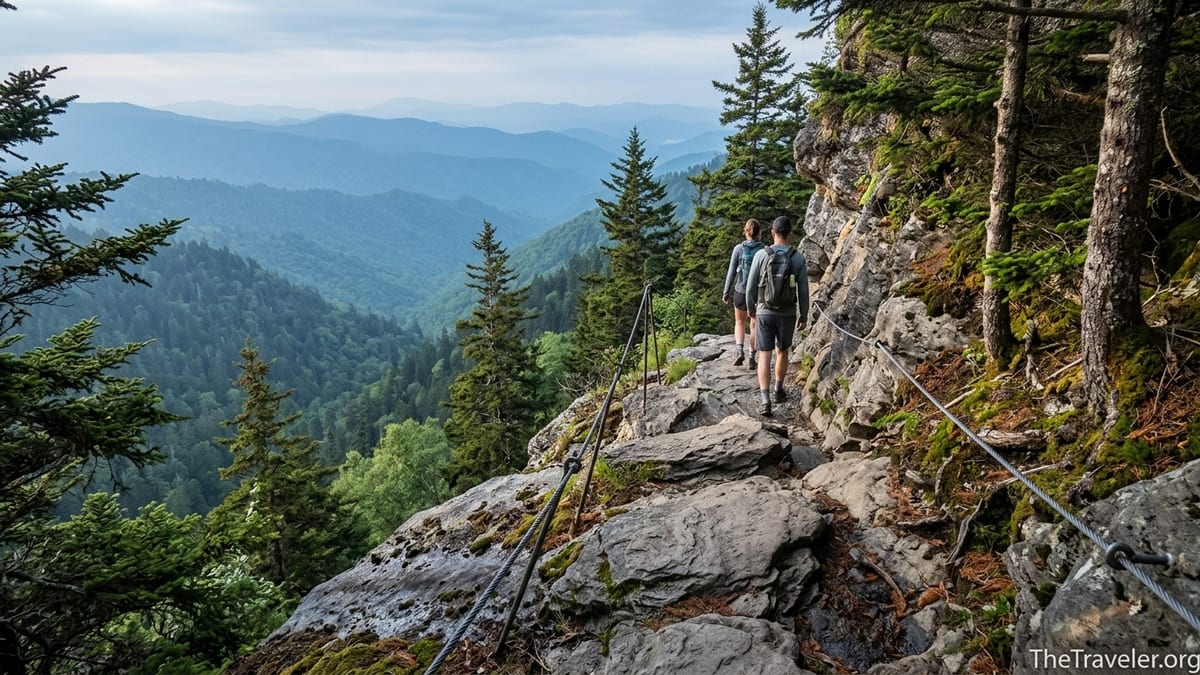
Why Mount Le Conte Feels So Much Harder
Several routes lead to Mount Le Conte, but nearly all share the same basic features: significant elevation gain, uneven footing and exposure to rapidly changing weather. Alum Cave, the classic route from Newfound Gap Road, climbs roughly 2,700 vertical feet over about 5.5 miles one way to the lodge area near the top, then continues another short distance to the true high point. The trail begins gently along Alum Cave Creek, lulling many day hikers into thinking they are on another friendly Smokies walk.
Past Arch Rock, where you climb stairs through a narrow slot in the rock, the grade steepens. By the time you reach the overhanging bluff of Alum Cave itself, about 2.3 miles in, your legs already feel the climb. Many people turn around here, calling it “the Alum Cave hike” and rating it as manageable. Those who push on toward Le Conte quickly discover why experienced locals advise treating it as an all day effort rather than a casual morning outing.
Beyond Alum Cave the trail becomes rockier and more exposed. In several stretches, particularly as you approach the ridge, the path narrows to ledges crossing steep slopes, with fixed cable handrails drilled into the rock for security. In dry late summer conditions these sections feel adventurous but safe. In April, when overnight temperatures still drop below freezing at higher elevations, those same ledges can glaze with ice. Rangers routinely remind visitors that lightweight traction like microspikes is a smart idea for anyone attempting Le Conte in shoulder seasons.
Other routes, such as the Boulevard Trail from Newfound Gap or the Trillium Gap Trail from the Roaring Fork Motor Nature Trail, trade some of Alum Cave’s exposure for extra distance. The Boulevard route adds several miles of rolling ridge walking, while Trillium Gap stretches the trip to roughly 13 miles round trip. Hikers used to two or three mile waterfall strolls around Gatlinburg often underestimate how different a full day, double digit mileage outing with thousands of feet of climbing will feel, especially at Southern Appalachian humidity levels in July or August.
The Trail Experience: Alum Cave To Le Conte In Real Life
Picture a July morning in a Gatlinburg hotel. At 7 a.m., the parking lot at Alum Cave trailhead is already filling. A family that hiked Laurel Falls the previous day arrives with the same small daypack, two bottles of water and a single bag of trail mix for four people. The first mile feels familiar: wooden bridges, cool air along the stream and well groomed tread. Spirits are high and phones come out for photos at Arch Rock.
By the time this group reaches Alum Cave Bluffs around mid-morning, the sun is higher, humidity has climbed and the grade has become relentless. Children start to drag their feet. One adult realizes they have only a third of their water left. A conversation begins about whether to stop here, enjoy the view and head back. Nearby, a pair of trail runners with 20 liter hydration vests and trekking poles refuel quickly and press on toward the summit, aiming to reach Le Conte Lodge by noon.
Beyond the bluff, the family notices the trail surface change. Long stretches of angled, sometimes wet rock replace packed dirt. They begin to use the cable rails not out of novelty but for balance. The forest, once dominated by hemlocks and hardwoods, shift toward the spruce fir zone. When they finally reach the Le Conte Lodge complex, more than five miles from their car, they are shocked to find basic but bustling cabins, a rustic dining hall and a small office where day hikers can buy a cup of hot chocolate for a few dollars and sign the guest register. The temptation to linger is strong. The realization that the entire descent still lies ahead is stronger.
That same afternoon, as afternoon thunderstorms roll in, the difference in preparation becomes obvious. Well equipped hikers pull on lightweight rain shells, stow cameras in dry bags and continue carefully. Others, shivering in cotton T shirts, cluster under the eaves of the lodge until the rain slackens. The actual walking on Le Conte is never technical in a mountaineering sense, but the combination of distance, grade, footing and fast moving weather systems is enough to turn a good story into a rescue call if visitors go up with only the gear they used on shorter valley hikes.
Easy Smokies Hikes That Mislead First Timers
Part of Mount Le Conte’s sting lies in the contrast with the park’s most popular “easy” trails. Laurel Falls, as one example, allows visitors to experience an iconic two tiered waterfall in under two hours round trip. The path is paved for most of its length, and while it has some steep, uneven sections, many walkers tackle it in sandals or slip on shoes. The payoff feels large for the effort, and this resets expectations. Deep Creek, on the North Carolina side of the park, offers a mellow loop past three waterfalls, often completed in little more than an hour and a half with frequent stops for photos.
In Cades Cove, the loop road itself is a slow scenic drive with pullouts for short, mostly flat walks to historic cabins and churches. Even the popular Abrams Falls trail, which is around 5 miles round trip, mostly follows a creek and feels more like a forest ramble than a climb. Visitors can spend a long weekend linking these kinds of outings together and walk away thinking they have a good sense of what a “Smoky Mountains hike” is like.
Mount Le Conte breaks that pattern. Instead of a short paved approach, you face an all day mountain ascent. Instead of frequent access to facilities, there are no services between the trailhead and the top aside from the limited provisions at Le Conte Lodge, which is run under a concession contract and primarily serves overnight guests. Whereas Laurel Falls might see hikers in flip flops and cotton dresses, Le Conte is filled with people in trail shoes, carrying three to four liters of water, rain layers and calorie dense snacks.
Even the atmosphere is different. Crowds on easy trails tend to be noisy, filled with laughter and conversations about dinner plans in Gatlinburg or Pigeon Forge. On Le Conte, conversations often turn to pacing, weather windows and whether knees will hold up on the descent. That mental shift from casual sightseeing to backcountry travel is a hurdle that not every Smokies visitor expects to encounter.
Planning A Le Conte Attempt: Timing, Gear And Expectations
For those who understand the challenge and still feel drawn to stand on Le Conte’s summit, planning is everything. On a typical summer day, experienced hikers start up Alum Cave before sunrise to secure parking and avoid heat on the upper switchbacks. From Gatlinburg, that means leaving town around 5 a.m., often without the big resort breakfast that seemed so inviting the night before. If you are used to starting short hikes at 10 or 11 a.m., this pre dawn routine alone can feel like a commitment.
Gear expectations also change. On easy valley hikes, many visitors carry a single small bottle of water and a phone. For Le Conte, a 20 to 30 liter daypack with at least two to three liters of water per person, high energy food, a light insulating layer and a waterproof shell is far more appropriate. Trekking poles help take strain off knees on the descent, especially on the rougher sections below Alum Cave. In early spring and late fall, simple traction devices that slip over trail shoes can make the difference between a secure crossing of an icy patch and an uncontrolled slide.
Weather windows should guide your schedule more than dinner reservations. The Smokies are known for afternoon thunderstorms in late spring and summer.Building your day around reaching the summit before early afternoon, then descending before the most unstable weather, is a safer bet than gambling on clear skies. Likewise, winter or early spring hikers need to remember that it can be sunny and mild in Gatlinburg while the upper mountain remains locked in rime ice and strong winds. The National Park Service routinely encourages visitors to check conditions at higher elevations before committing to big climbs.
Setting realistic time estimates reduces stress. A fit, experienced hiker might cover the round trip via Alum Cave in six to eight hours with breaks. For casual visitors who are used to slow walks to waterfalls, budgeting ten hours from car to car allows room for rest, photos and weather delays. Tell someone where you are going, leave your expected return time and be willing to turn around if conditions deteriorate. In a park that feels so friendly, treating one trail with genuine mountain respect can feel unusual, yet that attitude is exactly what makes Le Conte rewarding rather than punishing.
Alternatives When Le Conte Is Too Much
For many travelers, the smart choice is recognizing that Mount Le Conte might simply be too much for this particular trip. The good news is that the Smokies offer several hikes that bridge the gap between short, flat walks and full day summit pushes. These trails allow you to experience steeper terrain and bigger elevation gain without committing to the full Le Conte effort.
Chimney Tops, for instance, offers a steep climb of about 1,400 feet over a couple of miles, with rewarding views near the new observation area below the former rock scrambling section. It is demanding enough to teach you how your legs and lungs respond to sustained grade, yet short enough that you can retreat to your car in a couple of hours. The hike to Charlie’s Bunion along the Appalachian Trail from Newfound Gap provides a taste of ridge walking, with sweeping views and some drop offs, but the overall exposure is more forgiving than the narrow ledges on Alum Cave above the bluff.
If you are drawn to waterfalls but want more challenge than Deep Creek or Laurel Falls, consider longer routes such as the trek to Ramsey Cascades or the loop combinations around Big Creek and Mouse Creek Falls. These outings introduce rougher footing, creek crossings and longer days without pushing you so far from the trailhead that a sudden storm becomes a major logistical problem. You can use them to refine your clothing choices, dial in how much food and water you really consume over several hours, and gain confidence moving on uneven terrain.
For visitors traveling with a mix of fitness levels, pairing a Le Conte attempt by the strongest hikers with easier valley plans for the rest of the group can keep everyone happy. While one or two people spend a long day on the mountain, others can explore Cades Cove, visit historic homesteads near Oconaluftee or take the children on the half mile Sugarlands Valley Nature Trail. Everyone meets up for dinner in town, swapping stories of black bear sightings in the cove and wind whipped views from the summit.
The Takeaway
Mount Le Conte has earned a special place in Smokies lore precisely because it so clearly separates casual hiking from genuine mountain travel. In a park where you can push a stroller to an 80 foot waterfall or drive to within a short walk of the highest observation tower, Le Conte demands an earlier alarm, heavier pack and more serious respect for the weather. The peak does not require ropes or technical skills, but it does require a willingness to move beyond the mindset that every Smokies trail is a gentle family outing.
For many travelers, that challenge becomes the heart of their trip. Standing near Cliff Top or Myrtle Point, looking out over ridges fading into blue distance, it is easy to understand why generations of hikers return to Le Conte year after year. For others, the wiser choice is to acknowledge that this may not be the season to tackle such a demanding route and instead savor the park’s easier trails. Either way, recognizing the difference between the friendly valley walks and the serious mountain above them is the key to a safe, satisfying Smokies experience.
FAQ
Q1. Is Mount Le Conte suitable for beginners who have only done easy Smoky Mountains hikes?
Mount Le Conte is usually too demanding for true beginners who have only done short, mostly flat trails like Laurel Falls or the Sugarlands Valley Nature Trail. If your experience is limited to one or two hour walks on paved or gently graded paths, you will likely find the distance, elevation gain and rough footing on Le Conte overwhelming. A better progression is to try several moderate hikes with at least 1,000 feet of climbing before committing to a full day on Le Conte.
Q2. How long does it typically take to hike Mount Le Conte via Alum Cave?
For fit, experienced hikers moving at a steady but not rushed pace, the round trip via Alum Cave often takes between six and eight hours including breaks. Visitors who are less conditioned, hiking with children, or stopping frequently for photos should plan for closer to nine or ten hours car to car. Starting early in the morning increases your margin of safety and gives you more flexibility if the day runs long.
Q3. What kind of gear do I need for a safe Mount Le Conte hike?
At minimum, plan to carry a real daypack with two to three liters of water per person, high energy snacks or lunch, a light insulating layer, a waterproof shell and a small first aid kit. Sturdy trail shoes or hiking boots with good traction are much safer than casual sneakers, especially on wet rock. Trekking poles help protect your knees on the descent. In early spring, late fall or winter, simple traction devices that slip over your shoes can improve security on icy sections near the ridge.
Q4. When is the best time of year to attempt Mount Le Conte?
Late spring through early fall offers the most reliable conditions for most hikers. In May and June, temperatures are cooler at higher elevations, but lingering ice is still possible on shaded sections. July and August bring warmer weather and afternoon thunderstorms, so early starts are important. Autumn offers cooler air and colorful foliage, but days are shorter. Winter attempts are best left to experienced hikers with proper cold weather gear and traction.
Q5. How does Mount Le Conte compare to other challenging Smokies hikes?
Mount Le Conte is often mentioned alongside hikes like Chimney Tops, Charlie’s Bunion, Ramsey Cascades and Rocky Top as one of the more demanding day outings in the park. Compared with these, Le Conte typically involves more overall elevation gain and a longer time commitment. Chimney Tops is shorter but quite steep, while Ramsey Cascades is a tough waterfall hike with rough footing. Le Conte stands out because it combines length, sustained climbing and the psychological impact of being hours away from the trailhead at high elevation.
Q6. Can I get water or food at the top of Mount Le Conte?
Le Conte Lodge offers limited services primarily aimed at overnight guests, including simple meals and hot drinks at set times. Day hikers can sometimes purchase basic items like a cup of hot chocolate or a branded drink mix packet, but you should not rely on the lodge as your main water or food source. Always carry enough water and calories for the entire round trip, treating anything available at the top as a bonus rather than a necessity.
Q7. What are good warm up hikes before trying Mount Le Conte?
Useful stepping stone hikes include Chimney Tops, the route to Charlie’s Bunion from Newfound Gap, longer waterfall hikes such as Ramsey Cascades, and ridge or loop options near Big Creek or Deep Creek. Aim for outings that cover at least 6 to 8 miles with 1,500 feet or more of elevation gain. Use these trips to test your footwear, refine your layering system and learn how your body responds to several hours of continuous hiking in Smokies humidity.
Q8. Is the trail to Mount Le Conte dangerous?
The main routes to Mount Le Conte are generally safe for prepared hikers in good conditions, but there are objective risks. Narrow ledges with cable handrails, steep drop offs, slippery rock when wet, sudden thunderstorms and winter ice all add seriousness. Most accidents happen when people underestimate the trail, start too late, carry too little water or attempt it in poor footwear. Respecting the mountain, checking conditions and turning around when something feels wrong are the best ways to manage risk.
Q9. Do I need a permit or special reservation to hike Mount Le Conte?
No permit is required for day hiking Mount Le Conte, but you do need a valid parking tag to leave your vehicle at trailheads inside Great Smoky Mountains National Park. Overnight stays at Le Conte Lodge, which operates under a limited season and fills quickly, require advance reservations made directly with the lodge’s concessionaire. Backcountry camping on routes connected to Le Conte requires permits from the park’s backcountry office and is subject to specific campsite quotas.
Q10. What should I do if I reach Alum Cave Bluffs and feel too tired to continue?
Turning around at Alum Cave Bluffs is a smart decision if you are already tired, low on water or concerned about the time. The bluff itself is a rewarding destination with wide views, and many hikers treat it as their goal for the day. Forcing yourself to continue when you are already struggling at this point almost always makes the descent more unpleasant and can increase the risk of slips or exhaustion. Enjoy the accomplishment, head back down at a comfortable pace and consider building more training hikes into your schedule before attempting the full Le Conte route.